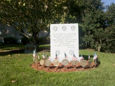
To honor all disabled veterans of Chester County who served their country and were wounded or injured in the line of duty
DAV 90 — — Map (db m49144) WM
Chartered by The State of Pennsylvania on April 22, 1890 this is the only Mutual savings bank in the County and is one of seven in the state. It is owned and operated for the benefit of the depositors. Previous locations of the bank were nearby on . . . — — Map (db m49388) HM
Chester County Remembers World War II Veterans
Community Commemorative Committee of Chester County
(1991 – 1995)
November 11, 1995 — — Map (db m49253) HM
The Petition of Joseph Martin of the Township of West Bradford in the County of Chester Humbly Showeth
“That there is a Necessity for a Publick house for the Entertainment of Travellers in said Township, there being many Large roads Much . . . — — Map (db m194170)
Farmer, Patriot, Public Servant. Cheyney was born and lived at this homestead his entire life. During the Battle of the Brandywine, he warned Gen. Washington of a British flanking movement. As a delegate to Pennsylvania’s 1787 convention, he voted . . . — — Map (db m188674) HM
(East Side): Erected by the Surviving Members of the Ninety Seventh Regiment Pennsylvania Volunteers to the Memory of Its Dead. Dedicated October 29, 1887
(North Side): Field and Staff Officers at the organization of the . . . — — Map (db m41062) HM
In Honor of
Residents of South Coventry
who served in World War II
1941 1945
*Michael Kopcho *Carrol E. Moses
John C. Asay • R. Carey Atkinson • Stanley Bealer • Thomas L. Bishop • George D. Bodor • Joseph J. Bodor • J. Penrose Boens . . . — — Map (db m41687) WM
Colonel Chester Co., Battalion of Minute Men July 21, 1775 Colonel 4th Penna. Infantry Battalion January 3, 1776 Brig. General Continental Army February 21, 1777 to November 3, 1783 Brevetted Major General September 30, 1783 “Resolved . . . — — Map (db m5673) HM
Indian Hannah The last of the Indians in Chester County was born in the vale about 300 yards to the East on the land of the protector of her people the Quaker assemblyman William Webb Her mother was Indian Sarah and her grandmother . . . — — Map (db m240065) HM
The Manor of Steyning
of 15,500 acres patented by
William Penn
for "Fatherly Love"
and one beaver skin yearly to his daughter
Laetitia Penn
at Philadelphia, October 23, 1701
is here marked on its western line adjoining . . . — — Map (db m52068) HM
Minguannan Indian Town
Was Located Here
The Chief
Machaloha or Owhala
and his people
of the Unami Group
* Their Totem * The Tortoise *
of the Lenni-Lenape or Delawares
Sold To
William Penn
The Lands between Delaware . . . — — Map (db m168374) HM
Simon Barnard Row
104-116 East Washington Street
227 North Walnut Street
These Row Houses were constructed about 1856 by Simon Barnard, local businessman, builder, realtor and Political Activist who was an advocate of the Anti-Slavery . . . — — Map (db m90315) HM
Side One:
Major Isaac Barnard
Born March 22, 1791
Died February 18, 1834
Side Two:
Senator of Pennsylvania, 1820:
Sec’y of The Commonwealth, 1826:
Senator of The U. States, 1827.
Side Three:
This Memorial in . . . — — Map (db m49594) HM WM
The Great Trail of the Minquas or Susquehanna Indians from the Susquehanna to the Schuylkill crossed the present road about this point. It was the path prior to 1670 for their conquest of the Lenni-Lenape or Delaware Indians and for trade with the . . . — — Map (db m8249) HM
Okehocking Indian Town
The Chiefs
Pokhais, Sepopawny, and Muttagooppa
With their people of the Unami Group
* Their Totem * The Tortoise *
Of the Lenni – Lenape or Delawares
were moved from lower Ridley and Crum Creeks
by . . . — — Map (db m159371) HM
In 1892, inventor Pusey received a U.S. patent for the paper matchbook. Three years later he sold his patent to the Diamond Match Company, and soon millions of matchbooks were being produced each year. A Civil War veteran and longtime Philadelphia . . . — — Map (db m71906) HM
The Battle of Paoli, also called “The Paoli Massacre”, occurred at midnight on September 20-21, 1777. After their defeat at Brandywine on September 11, Washington’s forces retreated toward Philadelphia, regrouped, and returned to Chester . . . — — Map (db m62398) HM
Built by Ferdinand Wood
Designed that the portals be
“Hi and wide as a load of hay”
Cost shared by Delaware and Chester Counties
Named for Mordecai Bartram
— — Map (db m92214) HM
Born 1798 in Mifflin County, Pennsylvania. Colonel John Purdy came to Tennessee in 1819. During the 1820s he served as Surveyor-General of the Ninth Surveyor’s District, with his office-home in Mifflin, which he named in honor of his Pennsylvania . . . — — Map (db m218360) HM
Pioneer home of Joseph Henry Taylor, soldier, trapper, hunter, author and printer by trade. Born in 1843 of Quaker parents in Chester County, PA., he drifted west, locating in the Painted Woods area, twelve miles south of here in 1869, where he led . . . — — Map (db m235199) HM
Built 1737 by Anna Nutt and Co. Made first Franklin stoves, 1742. Supplied shot and cannon for American revolutionists. Furnace a mile and a half away on side road; iron mines a mile west on the highway. — — Map (db m158387) HM
This location marks the approximate eastern boundary of the Worth / Jefferis Rural Historic District. The landscape that extends westward beyond the bridge before you exemplifies the formative character of Chester County's early 18th century era of . . . — — Map (db m242779) HM
Front The state of Pennsylvania authorized the “Thirteen Original Colonies Bicentennial Covered Wagon Train” as an official Bicentennial project. It was one of five such trains that traveled across the country to reach Valley . . . — — Map (db m55707) HM
Deer Creek Quaker Cemetery was established on land donated by Isaac Coates, who brought his family from Chester County, Pennsylvania to settle in Lexington Township in 1820. The name Deer Creek comes from the nearby stream and it signifies the . . . — — Map (db m78946) HM
Formed September 26, 1789 out of Chester County. Named for the Delaware River and site of William Penn's first entry into Pennsylvania, 1682. Old Chester Courthouse (1724) is one of America's early public buildings. County seat, Media, incorporated . . . — — Map (db m83368) HM
Minquas or Susquehanna Indians Susquehanna to the Schuylkill crossed Ridley Creek at Long Point 484 yards to the south. Thousands of beaver skins yearly were carried down to the first Dutch and Swedish Settlers on the Delaware. — — Map (db m72383) HM
Large iron ore and limestone deposits and dense forests that became charcoal, provided all the necessary elements to make Pennsylvania the leading iron producer in the American colonies. Durham Furnace, built in 1727 near the Delaware River in . . . — — Map (db m253021) HM
Built by Reverend John McCullough in 1849. Patterned after private Presbyterian schools in historic Chester County, Pennsylvania. The institution was a landmark in pioneer Texas education. Eminently suited for the purpose, the school compound . . . — — Map (db m143657) HM
Delaware boundaries are made up of three distinct lines.
* The 12-mile radius, surveyed 1701.
** The Transpeninsular Line, surveyed 1751.
*** The Mason-Dixon Line, surveyed 1763.
All the lines were completed even before Delaware became a . . . — — Map (db m153857) HM
"Chester's Mother"
During the 1780s squabble over removing the county seat
to West Chester, both sides ranted in the newspapers. This
excerpt from the ditty, "Chester's Mother," satirises Chester
citizens who feared losing their public . . . — — Map (db m188213) HM
Delaware boundaries are made up of three distinct lines.
* The 12-mile radius, surveyed 1701.
** The Transpeninsular Line, surveyed 1751.
*** The Mason-Dixon Line, surveyed 1763.
All the lines were completed even before Delaware became a . . . — — Map (db m156796) HM
“I have been East, Lincoln as far as Boston, and up into New Hampshire, travelling in all the New England States, save Maine; in New York, New Jersey, Pennsylvania, Ohio, Michigan, and Indiana; and everywhere I . . . — — Map (db m253451) HM
Listed on the
National Register of Historic Places, January 11, 2010
In 1910, this built-up steel plate through girder bridge was built for
Chester County on a farm-to-market road connecting area farms and mills
to market centers such as . . . — — Map (db m259456) HM
Historic Port Providence
More than 150 years ago, Port Providence was a bustling canal village. Although the canal boats have long since stopped, the village today stretches out along the canal with many familiar buildings. The Schuylkill . . . — — Map (db m160465) HM
Built c.1747 by Samuel Lightfoot, this mill provided feed and grain to the local community and exemplifies a turning point in American industrial technology. A rare surviving example of a colonial-era custom water-powered grist mill, its horizontal . . . — — Map (db m51310) HM
Patriot and Revolutionary War Hero * Commanded the Chester County “Flying Camp” Militia Regiment in American efforts to repel the British occupation of New York city * Captured upon surrender of Fort Washington and sent to infamous . . . — — Map (db m78172) HM
John H. Ware 3rd
August 29, 1908 – July 29, 1997
B.S. University of Pennsylvania; Chairman Penn Fuel Gas, Inc.; Former Burgess; Elected three terms to Pennsylvania Senate; Chairman, Republican Finance Committee of PA; Trustee, . . . — — Map (db m51111) HM
1827 -- Land is surveyed between
Philadelphia and Columbia,
Lancaster County for a new
transportation system to open
the state's interior to settlement
and commerce. The goal is to link
Philadelphia to Pittsburgh and
compete with New York's . . . — — Map (db m177595) HM
During the 1800's farmer’s took everything from a from a simple hoe to a thresher “snorting black smoke” into the fields in pursuit of better harvest.
Machines were run by hand, by oxen or horses, and finally by steam . . . — — Map (db m100662) HM
On September 3, 1777 over 800 Americans forming the Light Infantry Corps of Brigadier General William Maxwell engaged about 2,000 British Light Infantry and Hessian and Anspach "Jägers" (light infantry) in a series of skirmishes ending at . . . — — Map (db m157141) HM
A Chester Creek Meadow, Cheyney, Pa., c. 1906.
(From the Keith Lockhart Collection)
Farming in Thornbury Township
When Pennsylvania settlers ventured into Thornbury Township in the 1680s, the
land was not heavily forested. . . . — — Map (db m188432) HM
The Old Civic Square
Chester's old court house (pictured above) was built ca. 1724, making it the oldest building currently standing in downtown Chester, and one of the oldest remaining public buildings in the nation. The structure served . . . — — Map (db m310987) HM
Daniel acquired 450 acre tract From Thomas Rudyard in 1692, Main House built in three sections, 1692, 1794, 1801. East end oldest. Huge walk in fireplace — — Map (db m96011) HM
African people, first enslaved by the Dutch and Swedes, survived the brutal voyage from Africa to the Caribbean islands and the Americas, debarking on the Delaware River waterfront as early as 1639. William Penn, other Quakers, and Philadelphia . . . — — Map (db m298396) HM
(Front): 130 Pennsylvania
Volunteer Infantry 2 Brigade 3 Division 2 Corps (Rear): This memorial marks the regiment's right of line in battle. Its left extended to Roulette's Lane below. It went into battle by way of the Roulette Farm . . . — — Map (db m285866) HM
In 1778 Joseph and Hannah Hoskins moved to Guilford County from Chester County, Pennsylvania, and purchased 150 acres of land here from James Ross. During the Battle of Guilford Courthouse on March 15, 1781, the British army formed its first battle . . . — — Map (db m34841) HM
Since 1896, the 22-acre tract that is the final resting place for the victims of the Paoli Massacre has been under the watchcare and protection of the Paoli Memorial Association. In 1896, a small group of citizens petitioned the Court of Chester . . . — — Map (db m13664) HM
In the 1700's, Chester Creek drove Thornbury Township's economy. Water-powered mills ground flour, cut lumber, and made other goods to supply local farmers. Only remnants of those mills still exist.
At John Taylor's ironworks, Sarum Forge, . . . — — Map (db m232104) HM
The Homestead was built between 1823 and 1826 for Dr. John Simpson Bratton and his wife Harriet Rainey Bratton, the second generation of the Bratton family to live at Brattonsville. Bricks for the chimneys were made on the plantation. The two . . . — — Map (db m272030) HM
Caldwell’s Origins. Robert Caldwell and his family, from Chester County, Pennsylvania, moved to the Northwest Territory in 1795. In 1809 they bought and cleared land along Duck Creek in what became Olive Township, Morgan County (in 1819). In . . . — — Map (db m121653) HM
On the morning after the battle, Colonel Adam Hubley of the 10th Pennsylvania wrote, “I sent my Major [Caleb North] with 4 of our Horsemen on the field who counted our Dead bodys, the enemy’s were taken off…” The two or three . . . — — Map (db m13662) HM
Erected in 1812 for many years a flourishing classical and mathematical school stood on a site in the rear of this house the first president of the Board of Trustees was John Forsythe the first secretary was Dr. William Darlington. In 1869 this . . . — — Map (db m95982) HM
One of the premier music venues outside of Nashville, the park featured many of the biggest stars of country and bluegrass. Operated by the Waltman family from 1940 to 1995, it supported the transition from pre-WWII “hillbilly music” to . . . — — Map (db m135755) HM
In 1846 the Safe Harbor blast furnace, foundry and rolling mill, using anthracite for fuel, were built by Reeves, Abbott & Co. Great quantities of iron and rails were produced for the Pennsylvania R.R., incorporated in the same year. During the . . . — — Map (db m122690) HM
Fishing & Farming on the Potomac
This house witnessed the construction of the C&O Canal. Abner Cloud, born in Chester County, Pennsylvania, built this house in 1801 – 24 years before the creation of the Chesapeake & Ohio Canal Company. He . . . — — Map (db m238285) HM
In 1817, nearly 40 years after the Revolutionary War, the first parade commemorating the anniversary of the Paoli Massacre was held. More than 400 volunteer troops participated “in a slow solemn march.” Three years after the Civil War . . . — — Map (db m13680) HM
When construction began in 1903, no other section of the Pennsylvania Railroad's (PRR) A&S Branch likely seemed as improbable as that along the western boundary of Manor Township. There was no existing path sufficient to the purpose of two-track, . . . — — Map (db m160247) HM
In the 18th century, thousands of French and German protestants migrated to Pennsylvania seeking religious freedom and rich farmland. George Beaver, a Huguenot from Alsace, arrived in 1741 and settled in Chester County.
A grandson, Peter . . . — — Map (db m311008) HM
The Cochran-Anspach House was built in 1821 by Isaiah Clark for Thomas Cochran, one of the first settlers of Millerstown. Cochran and his three brothers, Protestants, were forced to leave their native Ireland. After disposing of their land . . . — — Map (db m241846) HM
The Town of Whitehall properties were originally
purchased by the Welfare Foundation in 1984.
The Foundation was formed in 1930 by Pierre S.
du Pont and is headquartered in Wilmington,
Delaware. The mission of the organization is to
promote the . . . — — Map (db m294765) HM
THE HALLOWED GROUND OF THE MEDAL OF HONOR GROVE
IS THE OLDEST LIVING MEMORIAL DEDICATED TO THE SERVICE
AND SACRIFICE OF THE RECIPIENTS OF THE MEDAL OF HONOR.
Within today's 42-acre Grove is a dedicated area of land for each of the . . . — — Map (db m232443) HM WM
The metal truss bridge that stands before you marks the location of Jefferis' Ford. The ford is named after the Quaker family of Emmor Jefferis, the Revolutionary War-era owner of Blue Rock Farm located at the intersection of Lucky Hill and Allerton . . . — — Map (db m242783) HM
Danville is a distinctive, historic community noted for iron heritage and connections to health care. Named after the son of founder William Montgomery, Danville was first settled in 1776. Local iron ore deposits fed the growth of a bustling . . . — — Map (db m192579) HM
The Narrows of the Harpeth is rich in natural and cultural features. The most beautiful and unusual natural feature is the long narrow wall of limestone surrounded by a five mile loop of the river that returns to within 200 feet of itself . . . — — Map (db m248944) HM
(side 1)
Hugh Williamson
Born Dec. 5, 1735
Chester County
Pennsylvania
Died May 22, 1819
New York City
Buried in
Trinity Churchyard
Framer and Signer
of the
U.S. Constitution
Citizen of
Edenton, . . . — — Map (db m225264) HM
In 1907, after 25 years of effort, the residents of Chester and Lancaster Counties successfully petitioned their
respective Courts of Quarter Sessions for a new bridge crossing the East Branch Octoraro Creek at this location,
replacing a ca. 1840, . . . — — Map (db m175366) HM
The Rock Hill City Directory listing of businesses that were operating on West Black Street in the late 60s and early 70s.
1. Blue Bird Taxi Company (1972)*
2. Brown's Billiards (1971)
3. People's Undertaking Company (1972)
4. Mutt's . . . — — Map (db m175680) HM
Thin black lines indicate changes in relevance. Between each pair of lines entries are ordered geographically but all have the same relevance.
* Inflectional forms of words are their plurals, singulars, and possessives as well as gramatical tenses and similar variations.