Near University Drive north of Stadium Road, on the right when traveling north.
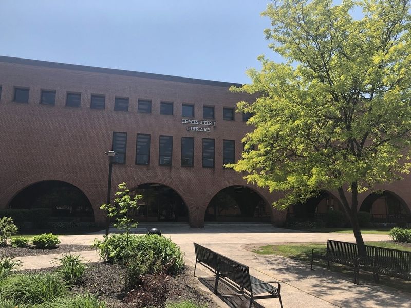
In 1976, the library opened as the fourth location for institutional book holdings. In 1990, this building was named as the Lewis J. Ort Library to honor local business man and philanthropist. — — Map (db m134529) HM
Near East College Avenue east of Maple Street, on the right when traveling east.
In 1954 Lowndes Hall was completed. This building was named for two members of the Lowndes family - Lloyd, former governor of Maryland, and his son Taster, former President of the Maryland Board of Education. — — Map (db m134530) HM
On National Highway (U.S. 40) at Maryland Route 36, on the right when traveling east on National Highway.
General Braddock's 2nd camp on the march to Fort Duquesne June 14th, 15th, 1755. The old Braddock Road passed to the southeast of the National Road from Clarysville to the "Shades of Death" near "Two Mile Run." The National Road was begun by the . . . — — Map (db m177600) HM
Near Center Street east of East College Avenue, on the left when traveling north.
The Nelson P. Guild Human Resources Center opened in 1986, incorporating several existing buildings: Alleghany Hall, the second Laboratory School, and Garrett Hall. The Center is named for Dr. Nelson P. Guild, sixth president of the University . . . — — Map (db m134526) HM
Near East College Avenue at Wood Street, on the right when traveling east.
Ground was broken for Old Main on June 27, 1899. It was completed in 1900. This building was originally known as the Normal School. The colloquial use of the phrase "Old Main" was confirmed with the building's dedication in 1957. — — Map (db m134383) HM
On East College Avenue at Wood Street, on the right when traveling east on East College Avenue.
Frostburg State College was founded as a "Normal" school (two-year institution) by an act of the Maryland General Assembly in 1893. The cornerstone for Old Main, first building erected for the college, was laid in 1899. The school opened in 1902 and . . . — — Map (db m134382) HM
On University Drive south of Planetarium Drive, on the right when traveling south.
In 1983, the Public Safety Building opened. This building was formerly the Lincoln School, a public school for African-American students. — — Map (db m134385) HM
On Braddock Street (Maryland Route 736) west of Park Avenue, on the right when traveling west.
Pullen Hall, opened in 1959, is named for Dr. Thomas G. Pullen, Jr., State Superintendent of Schools. The building originally served as the third location of the laboratory elementary school and now houses various student service departments. — — Map (db m134388) HM
Near Environmental Drive north of Planetarium Drive, on the right when traveling north.
In 1957, I. Jewell Simpson Residence Hall for women was completed. This building was named for the State Supervisor of Elementary Schools who served as the Assistant State Superintendent of Schools for Elementary Instruction. — — Map (db m134379) HM
Near Center Street south of Oak Street, on the left when traveling north.
In 1965, Lowell Martin Sowers, Sr., Residence Hall for men was completed. This building was named for the college science professor who taught from 1950 - 1961. — — Map (db m134525) HM
On 1st Street close to Uhl Street, on the right when traveling west.
Erected in 1912, the St. Michaels' Parish Hall served the members of St. Michaels' Church and the Frostburg Community for the past 100 years. As the St. Michael parish continued to grow at the end of the 19th century, a school was added in 1891. . . . — — Map (db m199917) HM
The Railroad had reached Frostburg in 1852 and by 1863, the Cumberland and Pennsylvania (C&P) line ran from Cumberland through Mt. Savage to Frostburg and down George's Creek across the Potomac River to Piedmont, West Virginia. This connected the . . . — — Map (db m96386) HM
On West Main Street (Alternate U.S. 40) north of South Water Street, on the right when traveling south.
1917 • 1918
The Memorial Window above the doorway and this tablet are here placed in honor of the boys of this church who served their country in the Great World War for liberty and justice
Roll of Honor
Victor W. Bennett • Stanley . . . — — Map (db m176073) WM
Contrary to popular belief that it was named for its frigid winter weather, Frostburg can trace its history back to 1800 when the community was known as Mt. Pleasant. By the time the National Road (authorized by Congress in 1806) opened through in . . . — — Map (db m167992) HM
A trolley car and horse and buggy descend the old National Road at Eckhart Hill, just east of Frostburg. In 1806 construction of the Cumberland (National) Road was authorized by Congress. Its purpose was to connect the populated east and "navigable . . . — — Map (db m96383) HM
On Eckhart School Drive south of National Highway (Alternate U.S. 40), on the right when traveling south.
In memory of the heroic boys of Eckhart
who gave their lives in
World War I and II.
World War I. 1917-1918
Edward T. Barry • Thomas W. Barry • Samuel T. Campbell • George McLaughlin • Paul Rairick
World War II. 1941-1945
William J. . . . — — Map (db m176280) WM
On East Main Street (Alternate U.S. 40) at Jenkins Street, on the left when traveling west on East Main Street.
God bless America our home sweet home
This memorial is dedicated to the men who gave their last full measure of devotion to their country. May God
continue to bless America. — — Map (db m177599) WM
On East Main Street (Alternate U.S. 40) at Jenkins Street, on the left when traveling west on East Main Street.
Farrady Post 24 Honor Their Deceased Heroes
Died In The Service Of Their Country
1941-1945
William J. Andres •
Arthur M. Arnone •
Kinney E. Baxter •
David Beck •
Noah J. Beeman •
Evan B. Boyer •
Darby J. Brady •
William P. . . . — — Map (db m178782) WM
On East Main Street (Alternate U.S. 40) at Jenkins Street, on the right when traveling west on East Main Street.
For those same principles of freedom, equality, justice, and humanity for which American Patriots sacrifice their lives and fortunes this tablet was erected by the citizens of Frostburg, Maryland.
May thirtieth, nineteen twenty.
1917 - Died . . . — — Map (db m177926) WM
On Clarysville Road SW at Vale Summit Road (Maryland Route 55), on the right when traveling south on Clarysville Road SW.
The Clarysville Inn once stood in front of you to the right. In this tavern, and in a complex of buildings constructed around it, the United States established a general hospital during the Civil War. On March 6, 1862, U.S. soldiers commandeered . . . — — Map (db m37540) HM
Near Old Town Road (State Highway 51), on the right when traveling east.
The Paw Paw Tunnel stands as a monument to the ability and daring of 19th century canal builders. By building the mile-long cut through the mountain, including the 3,118-foot tunnel, the canal avoided six miles of river bends and steep, rocky . . . — — Map (db m25098) HM
The Potomac River meanders through six miles of bends here with steep cliffs dropping to the river, making the digging of a ditch canal nearly impossible. The canal company could have followed a natural fold (1) in the rock stratification to . . . — — Map (db m140022) HM
Walk in the footsteps of the Irish and German laborers who built the Paw Paw Tunnel. Follow a portion of the access road they travelled to get to labor housing and work camps near the vertical shafts on the top of the mountain. Enjoy Potomac . . . — — Map (db m140024) HM
On National Highway (Alternate U.S. 40) 0.4 miles west of Winchester Road (Maryland Route 53), on the left when traveling west.
Dedicated to
the pioneers who
with heroic sacrifice
and undaunted courage
blazed this old trail
now known as
the National Highway
and thus opened
"The Gateway to the West" — — Map (db m199894) HM
On Vocke Road (Maryland Route 53(658)) south of Exit 40 (Interstate 68).
General Braddock’s 1st camp on the march from Fort Cumberland to Fort Duquesne, June 11th to 13th, 1755. After building a road over Wills Mountain, Spendelow, an engineer, discovered a route by “The Narrows” and Braddock’s Run and a . . . — — Map (db m2083) HM
Near Cash Valley Road south of Stoney Creek Drive, on the right when traveling south.
In 1912 a Western Maryland Railway cut near Cumberland exposed a small cave. The cave, which became known as the Cumberland Bone Cave was found to contain a remarkable variety of bones from species now extinct. Paleontologists were called in from . . . — — Map (db m203720) HM
On National Highway SW (U.S. 40), on the left when traveling west.
First toll gate house on the old National (Cumberland) Road. Erected about 1833 after this portion of the road was turned over to the State of Maryland by the United States government. There was one other toll gate in Maryland on this Road. — — Map (db m442) HM
Near National Highway SW (U.S. 40), on the left when traveling west. Reported permanently removed.
Toll houses were built along the National Road as a result of a 25 year national debate as to whether or not the federal government should be responsible for funding road improvements. While there was agreement on the idea that those who used the . . . — — Map (db m443) HM
On National Highway (Alternate U.S. 40) 0.4 miles west of Winchester Road (Maryland Route 53), on the left when traveling west.
Toll houses were built along the National Road as a result of a 25 year national debate as to whether or not the federal government should be responsible for funding road improvements. While there was agreement on the idea that those who used the . . . — — Map (db m199902) HM
On National Highway (Alternate U.S. 40) west of Mary Court, on the left when traveling west.
Was the first of the internal improvements undertaken by the U.S. Government. Surveys were authorized in 1806 over the route of “Braddock’s Road,” which followed “Nemacolin’s Path,” an Indian trail, over which George . . . — — Map (db m167131) HM
On National Highway (Alternate U.S. 40) at Klosterman Avenue, on the right when traveling west on National Highway.
With solemn pride and gratitude
we pay tribute to those who
served their country, especially
those who made the supreme
sacrifice in order that freedom
shall not perish from the earth. — — Map (db m174218) WM
Near Braddock Road (Maryland Route 49) at Gemma Drive, on the left when traveling east.
This monument is dedicated to all who have served
honorably in the Armed Services of the United States,
especially to those who gave the ultimate sacrifice...
so that we, through Almighty God, remain a nation of free people
An Eagle Scout . . . — — Map (db m178915) WM
Near Braddock Road (Maryland Route 49) at Gemma Drive, on the left when traveling east.
These Lions Memorial Field Park and Armed Services monument improvements are dedicated to LaVale Lions who have passed away while keeping our motto "We Serve"
and to all who have served honorably in the Armed Services of the United States, . . . — — Map (db m179099) WM
On National Pike (U.S. 40), on the left when traveling west. Reported permanently removed.
The long, winding ascent of Town Hill reaches a height just beyond that of Sideling Hill, but was much more easily crossed. However, early automobiles were still no match for the steep grades and tight turns along this section of the National . . . — — Map (db m20986) HM
On National Pike Northeast (Scenic U.S. 40) at Tower Road, on the right when traveling east on National Pike Northeast.
The long, winding ascent of Town Hill reaches a height just beyond that of Sideling Hill, but was much more easily crossed. However, early automobiles were still no match for the steep grades and tight turns along this section of the National . . . — — Map (db m199930) HM
On Main Street (Maryland Route 36) at Union Street, on the right when traveling north on Main Street.
In the middle of the 1920 season, John "Jack" Dunn I signed Grove with the Baltimore Orioles of the International League, a minor league team. Grove led the league in strikeouts during his four seasons with the Orioles, and the team won the league . . . — — Map (db m139849) HM
On Main Street (Maryland Route 36) at Union Street, on the right when traveling north on Main Street.
In 1929, Grove opened "Lefty's Place"—a duckpin and ten-pin bowling alley and pool hall located diagonally from Lefty Grove Memorial Park, on Union Street. He operated the establishment, with help during the baseball season, until 1961. . . . — — Map (db m139842) HM
On Recreation Area Road Southwest, 0.6 miles south of Water Station Run Road, on the right when traveling south.
Daniel Cresap, pioneer settler, gave his name to Dan's Mountain and Dan's Rock. Born in 1728 near Havre de Grace, MD., son of Colonel Thomas Cresap. Fought in French and Indian War. By first wife, unknown, had one son; by second wife, Ruth . . . — — Map (db m98538) HM
On East Main Street (Maryland Route 36) just north of Dutch Row, on the left when traveling north.
Mary led the effort in forming the Lonaconing Furnace Park Association for preserving the Lonaconing Iron Furnace, now a historic landmark, and in establishing the community park at this location. Revered and beloved as a public school teacher for . . . — — Map (db m139086) HM
On East Main Street (Maryland Route 36) at Bridge Street, on the right when traveling south on East Main Street.
Named to the National Register of
Historic Places — June 19, 1973
Presented by the Preservation Society
of Allegany County, Inc.
May 1974
— — Map (db m139084) HM
On East Main Street (Maryland Route 36) at Bridge Street, on the right when traveling south on East Main Street.
Midway between the towns of Frostburg and Westernport stands the Lonaconing Iron Furnace - a mute reminder of a once important industry in the George's Creek valley.
The George's Creek Coal & Iron Company was founded in 1835. In 1836, an act of . . . — — Map (db m139083) HM
On Main Street (Maryland Route 36) just south of Pershing Street, on the right when traveling south.
In Honor and Remembrance
of the Heroes and Victims in the
Fight Against Terrorism
and to Celebrate the
Enduring Spirit of All Americans — — Map (db m139065) WM
On East Main Street (Maryland Route 36) at Pershing Street, on the left when traveling north on East Main Street.
Sacred to the memory of
the boys of our community
who made the Supreme Sacrifice
in World War II
1941 - 1945
Pvt. James G. Allan
S.Sgt. Harry Atkinson
T.Sgt. Porter Broadwater
Pvt. Thomas D. Gallagher
P.F.C. Alvin Neat . . . — — Map (db m139067) WM
On West Main Street (Maryland Route 36) just south of Pershing Street, on the right when traveling south.
Founded in 1837 by the Georges Creek Coal and Iron Company, Lonaconing has endured its share of disasters. On September 7, 1881, a devastating fire wiped out the entire business district. Although the town rebuilt, the community suffered through . . . — — Map (db m139064) HM
Central High School
1890 - 1975
With Love and Loyalty
The Alumni dedicates this memorial plaque to the Alma Mater
Semper Fidelis — — Map (db m215877) HM
On East Main Street (Maryland Route 36) just north of Pershing Street, on the left when traveling north.
In loving memory of
those who heard the call and answered it.
★ ★ ★
Died over seas
Brigadier General James F. McIndoe
Capt. Gustave A. Schaidt
Pvt. William S. Brown
Killed in . . . — — Map (db m139074) WM
On Main Street (Maryland Route 36) at Union Street, on the right when traveling north on Main Street.
In 1925, following a stellar four-and-a-half-year stint in the minor leagues with the Baltimore Orioles, Grove began his major league career with Connie Mack's Philadelphia Athletics. Struggling with pitching control during his rookie year, Grove . . . — — Map (db m139848) HM
On Main Street (Route 36) at Union Street, on the right when traveling north on Main Street.
At the end of the 1933 season, Grove signed with Tom Yawkey's Boston Red Sox, where he would spend the last eight years of his career. He won four more ERA titles with the Red Sox and became a member of major league baseball's elite 300-win club . . . — — Map (db m139846) HM
On East Main Street (Maryland Route 36) at Bridge Street, on the right when traveling south on East Main Street.
A native of Lonaconing, Lefty Grove was one of baseball's all-time great pitchers. In 17 seasons (1925-1941) as a Major Leaguer, he won 300 games and lost 141 for a .680 percentage.
Pitching for Philadelphia and Boston, he led the American . . . — — Map (db m139077) HM
On Main Street (Maryland Route 36) at Union Street, on the right when traveling north on Main Street.
Robert Moses "Lefty" Grove was born in the Charlestown section of Lonaconing, Md., on March 6, 1900, to John and Emma Catherine (Beeman) Grove. Raised in a coal mining community during times of desperate poverty, young Grove had to abandon his . . . — — Map (db m167364) HM
On East Main Street (Maryland Route 36) just south of Bridge Street, on the right when traveling south.
Bill Turnbull was the original owner of the coal car. The car was removed from the Turnbull mine in 1985.
Second owner of the car was Bob Phillips. The car was then used as a decorative yard item.
In 1987 the car was moved to the . . . — — Map (db m139087) HM
On Main Street (Maryland Route 36) at Union Street, on the right when traveling north on Main Street.
This collaboration project, in memory of one of baseball's greatest pitchers, began in October 2014 with the formation of "The Lefty Grove Memorial Committee." A labor of hometown love, the park honors Robert Moses "Lefty" Grove — recognizing . . . — — Map (db m139845) HM
On Pratt Street (Maryland Route 135) north of Grant Street, on the left when traveling north.
World War I
Timothy A. O'Leary • Hugh A. Sterling
☆
World War II
Francis H. Dawson • Charles R. Dayton • Armeda W. Grove • Morrison A. Holland • Edward R. Kooken • Leonard A. Saville • Charles W. Stevey
Korea
Anthony P. . . . — — Map (db m180062) WM
On Westernport Road (Maryland Route 135) east of Dayton Hill Lane, on the left when traveling east.
In Honor and Remembrance
of the Heroes and Victims in thë
Fight Against Terrorism
and to Celebrate the
Enduring Spirit of All Americans — — Map (db m179985) WM
On Broadway Street just north of New Georges Creek Road Southwest (Maryland Route 36), on the right when traveling north.
In Memory of
Those who died in the service
of their country
World War I
James I. McKenzie
John J. Seib
World War II
Joseph B. Allen
James J. Blubaugh
Charles J. Bullick
Edward J. Bullick
John F. Campbell . . . — — Map (db m139852) WM
Near Trimble Road Northwest, 0.6 miles east of Slabtown Road Northwest, on the right when traveling east.
Built circa 1780, the Federal Hill / Evergreen Barn is a well-preserved example of a stone foundation Pennsylvania or Sweitzer Style Barn. It is built into the side of the hill to allow access on both levels. Hand-hewn logs create a cantilevered . . . — — Map (db m177944) HM
On Trimble Road Northwest, 0.6 miles east of Slabtown Road Northwest, on the left when traveling east.
The historic Federal Hill / Evergreen House was built in stages, beginning circa 1780 with a log/frame house built by Edward Grimes. Circa 1822, George Winter added onto the front porch of the Grimes' house, which faced
southward toward the Barn, . . . — — Map (db m178468) HM
On Mount Savage Road, on the right when traveling east. Reported missing.
Who served their country in the World War, this bridge was built, and in loving remembrance of J. Edward Carney • Walter H. Green • Lloyd H. Hartman • Joseph B. Hammers • Lawrence B. Miller • James Shaffer • H. Earl Snyder who made the supreme . . . — — Map (db m176024) WM
On Mount Savage Road NW (Maryland Route 36) east of Iron Rail Street, on the right when traveling east.
Who served their country in the World War, this bridge was built, and in loving remembrance of J. Edward Carney • Walter H. Green • Lloyd H. Hartman • Joseph B. Hammers • Lawrence B. Miller • James Shaffer • H. Earl Snyder
who made the supreme . . . — — Map (db m177378) WM
On Mount Savage Road NW (Maryland Route 36) east of Iron Rail Street, on the right when traveling east.
Upon declaring war against Germany, the United States joined their allies, Britain, France, and Russia, in World War I on April 6, 1917. The government formed a new national army using volunteers and draftees. Many of the Mount Savage men enlisted . . . — — Map (db m176958) HM
In 1844, the first iron rails made in the United States were produced on this spot by the Mount Savage Iron Works. Erected in 1839, the iron works contributed extensviely to the development of the Mount Savage Community. — — Map (db m5846) HM
Near Mount Savage Road (Maryland Route 36) at New Row Road.
On this site in 1844 were rolled the first iron rails made in the United States. For this technological achievement, the Mount Savage Iron Works was awarded a silver medal by the Franklin Institute of Philadelphia
This plaque was dedicated in . . . — — Map (db m114318) HM
Near Mile Lane Northwest at Glen Savage Farm Road, on the left when traveling east.
Our Dead Are Not Unknown Soldiers
1969
(Additional marker is at ground level in front of main memorial and is barely legible):
To our Nation's unsung Viet Nam Prisoners of War
Vietnam Veterans to your memory and sacrifice the theme of . . . — — Map (db m177533) WM
Near St Patrick's Church Road east of New Row Road NW, on the right when traveling east.
This monument commemorates St. Patrick School that stood near this site from 1900 to 2001. The cornerstone and bricks are from the original school. — — Map (db m177376) HM
On Mile Lane Northwest at Glen Savage Farm Road, on the left when traveling east on Mile Lane Northwest.
Mass was first celebrated in Mt. Savage on this spot in 1793 by Rev. Stephen Theodore Badin, at the home of Archibald Arnold. Father Badin was the first Priest to be ordained in the United States.
About 1825 St. Ignatius Church was built on . . . — — Map (db m176406) HM
Near St. Patrick's Church Road east of New Row Road NW, on the right when traveling east.
This stone is a remaining part of the first catholic church in Mt. Savage. St. Ignatius Church, built in the late 1700's was located in what is now St. Patrick cemetery.
Stone donated by Jim and Margaret Robison — — Map (db m177377) HM
On Geary Lane north of Jealous Row, on the right when traveling north.
This property
The Castle
has been placed on the
National Register
of Historic Places
by the United States
Department of the Interior — — Map (db m134390) HM
On Lower Bank Street south of Iron Rail Street, on the right when traveling east.
This memorial is dedicated to all Veterans of the Mount
Savage community, living and dead, who served in the Armed Forces of the United States of America.
Americanism is an unfailing love of country; loyalty to
its institutions and ideals; . . . — — Map (db m177580) WM
On National Highway (U.S. 40) west of Mt. Savage Road NW (Maryland Route 36), on the right when traveling east.
The first iron rails made in the United States were manufactured in 1844 at Mount Savage. Before that time all iron rails were imported from England. — — Map (db m445) HM
Near River Road SE, 1.1 miles south of Pittsburgh Plate Glass Road SE, on the left when traveling west.
(front)
Pvt
James D Pollock
Co F
7 Va Cav
CSA
Aug 27 1841
Jan 27 1916
This grave is designated and protected by the Cumberland Historic Cemetery Organization
(rear)
This crypt was installed by the . . . — — Map (db m177267) HM WM
Near River Road SE, 1.1 miles south of Pittsburgh Plate Glass Road SE, on the left when traveling west.
She was a spy for the Confederate army during the Civil War. On April 12, 1864 she was charged with violating the laws of war when letters addressed to Gen. Robert E. Lee and President Jefferson were found on this great Confederate sympathizer. . . . — — Map (db m177266) HM WM
On Williams Road Southeast at Brice Hollow Road, on the right when traveling east on Williams Road Southeast.
Robert Twigg was the first Twigg to acquire land in what is now Allegany County, Maryland. In 1768 he purchased this land known as "Sink Hole Bottom". On this site, Austin D. Twigg (1863-1941) ran the Twiggtown General Store and Post Office as . . . — — Map (db m144697) HM
On Oldtown Cemetery Road at Opessa Street, on the right when traveling south on Oldtown Cemetery Road.
1694 - 1790
Pathfinder - Pioneer- Patriot
Founder of Oldtown about 1740
Surveyed first trail west 1751
Led in defense of settlers against hostile indians
Served in Provincial Assembly
Active in Sons of Liberty and
Committee of Safety . . . — — Map (db m177112) HM
On Green Spring Road just north of C&O Canal Towpath, on the right when traveling south.
With roots planted deep in the soil providing stability and a crown overhead providing shelter and safety, it is easy to see how a tree could be a meaningful symbol for the Sons of Liberty in America's earliest days. Each of the original 13 colonies . . . — — Map (db m99195) HM
On Old Braddock Trail south of Opessa Street, on the left when traveling west.
(preface) During the Civil War, retribution by one side for "atrocities” committed against civilians by the other quickly escalated. Confederate Gen. Jubal A. Early, during his 1864 Maryland invasion, demanded that several towns pay . . . — — Map (db m176330) HM
On Opessa Street at Green Spring Road, on the left when traveling east on Opessa Street.
He built his house, which can be seen nearby, about 1764. A trader, he cleared wilderness and fought Indians in “Cresap’s War” in Ohio, 1774. As a Captain he led riflemen, some painted Indian-style, to Boston at the start of the . . . — — Map (db m448) HM
On Oldtown Road (Maryland Route 51) at Opessa Street, on the right when traveling east on Oldtown Road.
Fording place for “Great Warriors Path” from New York to the South. Thomas Cresap built stockade fort here in 1741 used as a refuge during French and Indian War after Braddock’s defeat.
George Washington
was here on his first . . . — — Map (db m447) HM
On Green Spring Rd SE, 0.1 miles south of Opessa St.
The basin before you, above Lock 70, provided a landing for canal boats. A general store was built adjoining the original lockhouse. Across the lock a feed store was built. Boatmen could leave the hustle and bustle of Cumberland and tie up here to . . . — — Map (db m140010) HM
On Chesapeake & Ohio Canal Towpath (at milepost 172), 2.5 miles east of Kirk Hollow Road, on the right when traveling east.
On June 26, 1861, part of Confederate Lt. Col. Turner Ashby's 7th Virginia Cavalry clashed with a detachment of Co. A, 11th Indiana Infantry, on Kelley's Island 100 yards ahead of you. Both units were on patrol. The Federals had fought earlier that . . . — — Map (db m198466) HM
On Oldtown Rd SE, 0.2 miles east of Opessa Street, on the right when traveling east.
Private Eugene D. Deffinbaugh
Army KIA August 3, 1944
TEC5 Michael E. McCabe, Jr.
Army KIA December 19, 1944
Staff Sergeant Clifton C. Nixon
Army KIA April 11, 1945
PFC Edward L. Crabtree
Army KIA April 15, 1945
Staff . . . — — Map (db m139989) WM
The C&O Canal could be shut down by too much water...or too little. This steam pump maintained the water level during periods of drought. Foundation rubble is all that is left of the pump house that was built on this site in the 1870s. The original . . . — — Map (db m204848) HM
On Philos Avenue at Clay Street, on the left when traveling east on Philos Avenue.
This building is dedicated in remembrance of all those who took part
in all wars to preserve the freedom and liberty for our country who now sleep in peace in Philos and St. Peter's Cemeteries.
Erected in 1937 by W.P.A. Labor and funds . . . — — Map (db m179441) WM
On Main Street (Maryland Route 937) north of Ross Street, on the left when traveling north.
Dedicated to Those Who Lost Their Homes on This Site in the Flood of September 1996
Mr. & Mrs. John Armentrout • Mr. & Mrs. George Buckholtz • Mrs. Aleda Collins • Mr. Tom Elliott • Mr. & Mrs. Ellis Friend • Mr. Brent Jackson • Mr. & Mrs. . . . — — Map (db m179430) HM
On New Georges Creek Road Southwest (Route 36) just north of Creek Side Drive Southwest, on the left when traveling north.
A tribute to the men, women,
and their families who
endured for freedom.
For God and Country
In Honor
Afghanistan and
Iraqi Freedom
Veterans
American Legion Posts 13 & 41
WWII Veterans
Honor . . . — — Map (db m139063) WM
On Washington Street east of Victory Post Road (Maryland Route 36), on the left when traveling east.
Dedicated to the glory of God and to the memory of those who paid the supreme sacrifice in all the great wars.
LEST WE FORGET
Dedicated to the glory of God and in memory of T. J. "Gannie" Martin. Soldier, service officer, humanitarian and . . . — — Map (db m180233) WM
On Main Street (Maryland Route 937) near Ross Street, on the right when traveling south.
Flooding. In 1996, two devastating floods caused catastrophic damage throughout a four county area of Western Maryland. The town of Westernport, located at the confluence of Georges Creek and the Potomac River, was one of the hardest hit by . . . — — Map (db m33699) HM
On New Georges Creek Road (Maryland Route 36) north of Creek Side Drive SW (Maryland Route 937), on the left when traveling north.
Originally Dedicated Aug. 27, 1944
Rededicated Aug. 27, 2006
Mary O'Haver •
James O'Haver •
Freda Arthur •
Carl Arthur •
Dorothy Brennan •
Willliam Barnard •
Allen Conrad •
Charles Winkler •
James Winkler •
Theodore Trenum • . . . — — Map (db m180501) WM
Near Halfway Boulevard at Oak Valley Drive, on the left when traveling north.
Civil War • MOH 1863
Corporal John W. Wagner
8th MO Infantry - Vicksburg, MS
Philippine War • MOH 1908
Corporal Seth L. Weld
8th US Infantry - La Paz, Leyte
Indian Wars • MOH 1891
Cpl. William O. Wilson
9th . . . — — Map (db m247747) HM WM
Near Halfway Boulevard at Oak Valley Drive, on the left when traveling north.
In memory of
Seaman Craig Wibberley
and
Fireman Patrick Roy
Who gave the ultimate sacrifice while serving aboard the U.S.S. Cole -DDG-67 on October 12, 2000 — — Map (db m247769) WM
Near Halfway Boulevard at Oak Valley Drive, on the left when traveling north.
In Memory of
1940 Class Members
Hagerstown High School
Killed in World War II or Korean Conflict
Pvt. William Bruce, USA •
Pfc. Warren Roth, USA •
Pvt. John W. Ernst, USA •
Sgt. George Shantz, Jr., USA •
2nd. Lt. C. Donald . . . — — Map (db m247750) WM
On Maryland Avenue north of State Circle, on the right when traveling north.
This is an example of "Ogham" writing. It is a style of Irish alphabet and writing dating from the 1st Century. It is read from the bottom to the top.
This sign says,
"Welcome to Galway Bay".
— — Map (db m114858) HM
On Maryland Avenue north of State Circle, on the right when traveling north.
This is an example of "Ogham" writing. It is a style of Irish alphabet and writing dating from the 1st Century. It is read from the bottom to the top.
This sign says,
"Go Navy, Beat Army" — — Map (db m232497) HM
7476 entries matched your criteria. Entries 201 through 300 are listed above. ⊲ Previous 100 — Next 100 ⊳