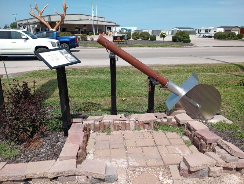
On Illinois Route 49 north of East Keach Avenue, on the right when traveling north.
Made by Trent Groothuis with help from Landon Hoehn & Brandi Millikan Year made: Spring/Summer 2020 Application submitted to Guinness World Records in June of 2020. Waiting to hear back in late Summer of 2020 to see if it meets the criteria for: . . . — — Map (db m229789) HM
On East Main Street west of 2nd Street, on the right when traveling east.
It's a story often told on the National Road. Two towns, both poised to prosper, grow up within walking distance of one another. One thrives. The other fades into the footnotes of history.
In the 1830s, Ewing Chancellor settled land along an . . . — — Map (db m152559) HM
On North Central Avenue (Illinois Route 49) at East Alabama Avenue, on the right when traveling north on North Central Avenue.
With gratitude to all the workers, for the children of tomorrow, we raise this bell to the glory of God: in the love of holiness, and to the cause and just pursuit of freedom.
This 48-inch, 2000-pound bell was part of the original United . . . — — Map (db m184622) HM
On Illinois 49 0.1 miles south of E 1700th RD, on the right when traveling north.
Discovery of oil in Pennsylvania in 1859 created nationwide interest. Signs of petroleum
seepage had been observed in Illinois long before 1865 when one of the first wells was drilled
about ½ mile north and ¼ mile east of here on the farm of T R . . . — — Map (db m248173) HM
On West Main Street west of South Central Avenue ( Route 49), on the right when traveling west.
With the opening of the National Road through this area, small communities began to the established along the route, one of which was Casey. The first settler was John Lang, a native of Scotland. Lang and family arrived from Ohio in 1838 and bought . . . — — Map (db m152488) HM
Near North 10th Street north of East Alabama Avenue, on the right when traveling north.
With the completion of the National Road (Cumberland Road) through Clark County in 1834, a settlement known as Cumberland was established in this vicinity. The settlement consisted mainly of workmen who moved here for the purpose of securing . . . — — Map (db m188290) HM
On West Main Street just east of Southwest 1st Street, on the right when traveling east.
On June 11, 2024, the people of Casey, Illinois gathered together inside the World's Largest Mailbox for a historic moment. The community sang, cheered and clapped along to the song "Casey Christmas." That magical holiday spirit was forever . . . — — Map (db m272783) HM
On East Main Street at Northeast 2nd Street, on the right when traveling west on East Main Street.
Since World War I, more than 91,000 American soldiers are unaccounted for. This unoccupied seat is dedicated to the memory of those brave men and women and to the sacrifices each made in serving this country.
God Bless You, God Bless . . . — — Map (db m184578) WM
On Darwin Ferry Road at North Union Street, on the left when traveling east on Darwin Ferry Road.
Darwin was the Clark County seat from 1823 to 1838. The County Courthouse was one block south from 1819 to 1823. The county seat was Aurora, once located two miles north. Two blocks east was the Darwin Steamboat Landing on the Wabash River. The . . . — — Map (db m152464) HM
On Interstate 70, on the right when traveling west.
Hiram B. Trout and his brother, Everett Trout, were born on a farm about five miles north of this location. They operated a machine shop in Shelbyville, Illinois in the late 1800’s at which in time they invented and patented the unique design for . . . — — Map (db m59336) HM
On Locust Street at South 6th Street, on the right when traveling east on Locust Street.
Has been placed on the
National Register
Of Historic Places
November 4, 2001
By the United States
Department of the Interior
Built 1872
— — Map (db m152565) HM
On Locust Street just east of South 6th Street, on the right when traveling east.
1904 Johnson Hall
1920 Hercules Paint Store & Sane Crystals
1954 Loyal Order Of Moose Lodge No. 1708
2008 Historic National Road Welcome Center — — Map (db m229786) HM
On Illinois Route 1 just south of Plum Street, on the left when traveling north.
From Here to Eternity author James Jones co-founded The Handy Writers’ Colony (1949-1964) at the West edge of Marshall with his mentor Lowney Turner Handy and her husband, Harry. Jones wrote Some Came Running here before moving to New . . . — — Map (db m23336) HM
On North 8th Street west of Michigan Avenue ( Route 1), on the right when traveling south.
Built at the intersection of Illinois' first state road and America's first federal highway, Marshall was a gateway community for immigrants traveling west. It was founded in 1835 by Illinois Gov. Joseph Duncan and Col. William B. Archer. . . . — — Map (db m152562) HM
To Commemorate
The Hundredth Anniversary of
Marshall, Illinois
Founded by
William B. Archer
and to Honor
George Rogers Clark
for whom the county was named — — Map (db m104797) HM
On National Road (Avery Avenue) (U.S. 40) east of Oak Crest Road, on the right when traveling west.
This Bridge was completed by Army Engineers sometime between 1834 and 1837 as part of the Old National Road, between Cumberland, Maryland and Vandalia, Illinois, was authorized by the enabling act of 1803 and was the Nation's first federally . . . — — Map (db m71127) HM
On Archer Avenue west of Michigan Avenue ( Route 1), on the right when traveling east.
This structure was erected in 1841 by Col. Wm. B. Archer, founder of Marshall, and John Bartlett and has been in continuous use as a hotel. It was an important stage coach stop on the early Cumberland Road where many prominent people, including . . . — — Map (db m152564) HM
On Archer Avenue at South 5th Street on Archer Avenue.
The Battlefield Cross originated during the Civil War as a means for soldiers to honor their fallen comrades on the battlefield. The helmet and dogtags represent the fallen soldier, the inverted rifle with bayonet symbolizes a time for prayer. The . . . — — Map (db m229781) HM WM
On Archer Avenue at South 5th Street, on the right when traveling east on Archer Avenue.
Since World War I, more than 82,000 American soldiers are unaccounted for. This unoccupied seat is dedicated to the memory of those brave men and women and to the sacrifices each made in serving this country. God Bless You, God Bless . . . — — Map (db m229780) WM
On East Clarksville Road (County Route 2150 N) 0.6 miles east of North 580th Street, on the right when traveling east.
On this site stood Margaretta Post Office, which served many northwestern communities of Clark County from 1840 to 1861. It was named for Margaret, wife of the postmaster, William B. Marrs. Mail was carried to the post office first in saddlebags by . . . — — Map (db m184585) HM
On East Main Street west of Mill Street, on the right when traveling east.
Imagine you're traveling the National Road in the late 1800s. Your wagon is one of many trundling toward town. The dirt road is rough and the ride uncomfortable, but you welcome the trip. It's a day to visit with friends, catch up on news, and trade . . . — — Map (db m152560) HM
On East Main Street at Mill Street, on the left when traveling east on East Main Street.
The Linn Family
The ancestors of the Linn Family immigrated from Ireland in 1809. They eventually settled in Parker Township in Clark County Illinois, near Westfield in 1864. Walter Linn and his family moved to Martinsville in the late . . . — — Map (db m242006) HM
On 1900th Street south of Hull Street, on the left when traveling south.
Fort Handy, built in 1816, was located 1200 feet southeast of this park on a knoll. The fort, the only structure of its kind in Clark County, was built by the family of Thomas Handy and contained three cabins and a well surrounded by a bulletproof . . . — — Map (db m152478) HM
On Liberty Church Road, on the right when traveling east.
Site of Liberty Church 1840 - 2005
In 1840, the United Brethren denomination
built the original church which was a log structure
About 1850, it was razed and a commodious frame building was erected.
The last building was erected in . . . — — Map (db m270563) HM
On West Lincoln Street (County Route 31) at South Fulton Street, on the right when traveling west on West Lincoln Street.
For more than fifty years Westfield College was located on this site. It was founded as a seminary in 1861 by the United Brethren in Christ and incorporated as a college in 1865. The school was coeducational from the beginning and in some years . . . — — Map (db m184588) HM
On West Lincoln Street at South Madison Street, on the right when traveling west on West Lincoln Street.
This marks the site of Westfield College 1865 - 1917 Presented by the
High School Class of 1932
2nd Plaque
Westfield Township High School 1921-1994 Class of 1932 — — Map (db m184589) HM
On North 1550th Street north of 1600th Avenue, on the right when traveling north.
Hutsonville was named after the Isaac Hutson family massacred by Indians in 1813 at a spot sixty four rods due east of this marker. Hutson was killed later in a skirmish with the Indians near Fort Harrison, Indiana. — — Map (db m152463) HM
Near Illinois Route 1 north of East 1900th Avenue, on the left when traveling south.
The original church was formed a few hundred yards north of this spot in 1871.
In 1924, the church moved to a new building in Hutsonville.
In 2008, the church building was razed. This cornerstone was removed and mounted here as a . . . — — Map (db m270569) HM
On South Range Street at West Missouri Street on South Range Street.
Since World War I, more than 91,000 American soldiers are unaccounted for. This unoccupied seat is dedicated to the memory of those brave men and women and to the sacrifices each made in serving this country. God Bless You, God Bless . . . — — Map (db m229795) WM
On South Main Street at East Grand Prairie Street, on the right when traveling north on South Main Street.
On this block Mary Ann (Elwell) Gogin operated a General Merchandise Store in the late nineteenth century.
One of the first women in Illinois to own and manage her own store. Mrs. Gogin was affectionately known as "Auntie" to the residents of . . . — — Map (db m23315) HM
On South Jackson Street north of East Harrison Street, on the right when traveling north.
Here stood the home of Edward N. Cullom who with Joseph Kitchell platted the Village of Palestine in 1818. They donated to the county the land including the Public Square for the County Seat. Early court sessions were held in the Cullom home. — — Map (db m23311) HM
On South Lincoln Street north of East Lamotte Street, on the left when traveling north.
Here stood the Dubois Tavern. Jesse K. Dubois, a close friend of Abraham Lincoln, was an official in the United States Land Office in Palestine from 1849-1853 and later became the Auditor of Public Accounts for Illinois. His son, Fred T. Dubois, . . . — — Map (db m23309) HM
On Illinois Route 33 at North Highway Street, on the right when traveling west on Illinois Route 33.
About 1813 the William Eaton family and other restless pioneers considered Fort LaMotte too crowded and therefore constructed a new stockade on a site several hundred yards North of here. A family trait of the Eatons, large feet, led to the name . . . — — Map (db m23319) HM
On East Lamotte Street at South Leaverton Street, on the right when traveling east on East Lamotte Street.
About 1812 the settlers in this area built Fort LaMotte for protection from hostile indians.
The pioneers farmed the adjoining land but stayed within easy reach of the protective walls.
After the War of 1812 the Indian threat diminished and . . . — — Map (db m23308) HM
On South Pike Street north of West Grand Prairie Street, on the left when traveling north.
On this site stood the home of Augustus C. French (1808-1864) when he was elected the ninth Governor of Illinois.
The early settlers in Illinois came mostly from Southern States so that French, a native of New Hampshire, was the first "Yankee" . . . — — Map (db m23318) HM
On East Grand Prairie Street at South Lincoln Street, on the left when traveling east on East Grand Prairie Street.
Two early residents of Palestine, John Houston and Francis Dickson, purchased this lot as the site for a combination dwelling and store about 1818.
By 1820 their stock of merchandise provided nearby settlers with goods which they previously had . . . — — Map (db m23313) HM
On Illinois Route 33 north of Vincennes Ave., on the left when traveling north.
In this area Joseph Kitchell who settled here in 1817 erected a Grist Mill and Distillery which eliminated the trip to Shakertown, Indiana where the farmers had previously taken their grain.
Horses were used for power, grain was taken in pay, . . . — — Map (db m23307) HM
On East Grand Prairie Street east of South Lincoln Street, on the right when traveling east.
Built in 1874 by the members of the First Christian Church of Palestine, the steeple bell came from a steamboat which had sunk in the Wabash River. The building was used as a church until Oct. 1916. It was also used as the first indoor gym for . . . — — Map (db m285460) HM
On East Main Street (Illinois Route 33) at North 1725th Street, on the right when traveling west on East Main Street. Reported missing.
This area reminded Frenchman John LaMotte of the land of milk and honey, Palestine. While a member of the LaSalle exploring party, he became separated from the group, traveled down the Wabash River, and first gazed upon the region in 1678. Other . . . — — Map (db m23328) HM
On Illinois Route 33 west of North 1650th Street, on the right when traveling west.
Usher - October 13, 1891 -- April 4, 1941. Built his first airplane in 1909. From 1913-1927 he learned to fly, barnstormed, and did stunt flying. Pilot and instructor for Interstate Airline and American Airways 1928-1930 and American Airlines . . . — — Map (db m23331) HM
On South Main Street at East Grand Prairie Street, on the left when traveling north on South Main Street.
The Fife Opera House, located on the second floor of the Fife Hardware Store, was built by David Fife. It operated from 1901-1912.
It seated 700 people on red leather seats, had electric fans and was heated with a coal furnace. There were five . . . — — Map (db m23314) HM
On North Main Street at East Market Street, on the right when traveling north on North Main Street.
A United States Land Office was located at this site in 1820 and operated until 1855. Settlers from as far as Chicago came here to file on homesteads.
Young Abraham Lincoln passing through Palestine in 1830 with his family in emigrant wagons . . . — — Map (db m23316) HM
On South Main Street north of East Harrison Street, on the left when traveling south.
Since World War I, more than 91,000 American soldiers are unaccounted for. This unoccupied seat is dedicated to the memory of those brave men and women and to the sacrifices each made in serving this country. God Bless You, God Bless . . . — — Map (db m285461) WM
On South Lincoln Street just south of East Walnut Street, on the right when traveling north.
Former Nuns of St. Elizabeth Church, Robinson, Illinois
Sr. Naomi Libiak, Dc 1978-1981 • Sr. Gaynelle Barrett, Dc 1978-1985 • Sr. Mary Dupont, Dc 1981-1987 • Sr. Catherine Mary Norris, Dc 1981 • Sr. Annina Bullock, Dc 1987-1994 • Sr. Rita . . . — — Map (db m229851) HM
On Douglas Street, on the right when traveling east.
This memorial is dedicated to all veterans and civilians who served and supported our nation in times of military conflict. The perpetuation of our constitutional freedoms is owed to these patriotic men, women and children. World War I . . . — — Map (db m281405) WM
On East 800th Avenue west of North 600th Street, on the right when traveling east.
During the early part of the Winter of 1906, DeWitte T. Finley made a location on the Shire farm, about six miles southwest of Robinson, and successfully drilled in the Shire No. 1. It was drilled to a depth of about one thousand feet, and . . . — — Map (db m229776) HM
On Illinois Route 49 at Palmero Rd (County Road 1425), on the left when traveling south on Illinois Route 49.
Following the French and Indian War (1754-1763), France ceded all claims to their North American Territory, called New France, to England in the Treaty of Paris (February, 1763). English troops quickly occupied many former French forts and . . . — — Map (db m298874) HM
On Illinois Route 49 at Palermo Road (County Road 1425) on Illinois Route 49. Reported permanently removed.
On the site of Palermo, three miles east of here, according to tradition George Croghan, Deputy Supt. of Indian Affairs, met the Ottowa Chief Pontiac in July, 1765, and made preliminary arragements for the peace which ended the Indian uprising known . . . — — Map (db m299246) HM
On Illinois Route 1 at County Route 1625 N, on the left when traveling south on Illinois Route 1.
One of the original Milestones which marked the trail from Vincennes to Chicago.
This stone was No. 93 which designated the number of miles from Vincennes. — — Map (db m11651) HM
On Illinois Route 1 south of Grapevine Road, on the left when traveling south.
One of the original Milestones which marked the Trail from Vincennes to Chicago.
This stone was No. 97 which designated the number of miles from Vincennes. — — Map (db m11658) HM
On U.S. 150 0.3 miles north of County Route 2500N, on the right when traveling south.
A few miles west of here on July 18, 1765, Pontiac, an Ottawa Chief, and George Croghan, British Representative, met in a formal peace council which ended the most threatening Indian uprising against the British in North America. Following the . . . — — Map (db m10997) HM
On Clarksville Street (aka: 625 E) north of County Route 500 N, on the left when traveling south.
Center Panel
To Honor
The Men and Women
who Have Served
Our Country
Left Panel
W W I Apr. 6, 1916 — Nov. 11, 1918
Atwill Augustus • Basil Bennett • Emil Bennett • James R. Bolin, Sr. • Rholand Fitzpatrick . . . — — Map (db m30946) WM
On North Main Street north of East Court Street, on the left when traveling north.
First Plaque - Front of Boulder
1775 - D. A. R. (Crest) - 1783
To the Honor and Glory
of the Soldiers of the
- American Revolution -
who are buried in Edgar Co.
Row One
Elijah Austin • Hugh Barr • James . . . — — Map (db m23460) WM
Lest We Forget World War I
Applegate, Henry A. • Baldwin, Otto • Boling, Carl • Burns, Jesse Ogden • Crawford, Alva • Crowder, Lester • Dalton, Claude H. • Dawson, William • Dengler, Lundy B. • Dibble, William H. • Dinsmore, Frank A. • Duck, . . . — — Map (db m189020) WM
On Circle Drive south of North Shore Drive, on the left when traveling south.
(left column:)
This memorial is dedicated to honor
the spirit and sacrifice of the brave men
and women of Edgar County who lost
their lives while serving in the United States
Armed Forces during the war in Korea 1950-1953 . . . — — Map (db m188352) WM
On East Court Street east of Central Avenue, on the left when traveling east.
Plaque One
These Millstones long in the Service
of our Pioneers dedicated to their memory
by the Edgar County Historical Society
1817 - 1927
Plaque Two
From the Lewis Jones Farm near Nevins
presented to
Edgar . . . — — Map (db m23457) HM
On Circle Drive south of North Shore Drive, on the left when traveling south.
(left column:)
To all who fought and lost their lives
To all who served in conflicts
around the world
in peace and wartime past and present
(right column:)
The Ultimate Sacrifice
1544th Illinois National . . . — — Map (db m188348) WM
On Circle Drive south of North Shore Drive, on the right when traveling south.
Paris lies in the heart of a rich farming area. Most of the land embraced in Edgar County, including Paris, remained Kickapoo hunting grounds until 1819, but the eastern quarter of the county was part of a tract ceded by the Indians in 1809 and . . . — — Map (db m188363) HM
On East Court Street east of South Main Street, on the right when traveling east.
This property has been
placed on the
National Register
of Historic Places
by the United States
Department of the Interior
Circa 1924 — — Map (db m226117) HM
Near West Steidl Road west of North Main Street ( Route 1).
Tom Sunkel was born on a farm just a few miles west of Paris. With the help of his uncle Paul McFall and his wife to be Ivadean he embarked on a 20 year journey in professional baseball. He distinguished himself as a pitcher with an amazing . . . — — Map (db m188362) HM
On Circle Drive south of North Shore Drive, on the left when traveling south.
(left column:)
This memorial is dedicated to honor
the spirit and sacrifice of the brave men
and women of Edgar County who lost
their lives while serving in the United States
Armed Forces during the war in Vietnam. . . . — — Map (db m188349) WM
On North Central Avenue south of East Wood Street, on the left when traveling south.
In 1834, Joseph Smith, prophet of the Church of Jesus Christ of Latter-Day Saints (LDS), together with about 200 LDS Volunteers from Kirtland, Ohio, marched to assist threatened church members in Jackson County, Missouri. Called “Zion’s . . . — — Map (db m23351) HM
On U.S. 36 west of 2250 E, on the right when traveling west.
The fertile prairies in Illinois attracted the attention of French fur trader Louis Jolliet and Father Jacques Marquette as they explored the Mississippi and Illinois Rivers in 1673. France claimed this region until 1763 when she surrendered it to . . . — — Map (db m131294) HM
On West Main Street (Illinois Route 15) east of School Road, on the right when traveling east.
Spoke in the oak grove of General William Pickering north of here in the presidential campaign of 1840. He was stumping southern Illinois as a Whig elector for General William Henry Harrison in the Tippecanoe and Tyler Too Campaign. In 1861 . . . — — Map (db m154578) HM
On 50 West Main Street (Illinois Route 15) at North 4th Street ( Route 130), on the right when traveling east on 50 West Main Street.
To Morris Birkbeck
Who in 1817 with George Flower founded the English settlement in Edwards County This memorial is erected by the Department of Illinois Woman's Relief Corps Auxiliary to the Grand Army of the Republic "In respect and gratitude . . . — — Map (db m154631) HM
On 850N east of County Road 315 E, on the right when traveling west.
The former village of Wanborough, Illinois, was established in August 1818 by English settler and entrepreneur Morris Birkbeck. A center of commerce for his fellow countrymen emigrating to the English settlement in Edwards County, Wanborough once . . . — — Map (db m177846) HM
On County Route 1570E at County Route 1200N, on the right when traveling east on County Route 1570E.
America at war in 1942 needed new bases to complete the training of its Army Air Corps cadets before they joined combat groups overseas. "Allison Prairie" in Lawrence County, Illinois, provided ideal conditions for a field due to its size and varied . . . — — Map (db m178179) HM
On 10th Street south of State Street (Business U.S. 50), on the right when traveling south.
"Do unto others as you would have them do unto you." - The Golden Rule
Founded by Michael Andrew Rooney, November 16, 1940. Golden Rule Insurance was originally headquartered in the Rooney home at 600 State St., Lawrenceville. History records . . . — — Map (db m178171) HM
On State Street (Business U.S. 50) east of 12th Street, on the right when traveling east.
The Lawrence County Courthouse, completed in 1889, is the third courthouse on this site. The first was built in 1824, the second in 1842.
On May 21, 1886, the Lawrence County Board of Supervisors met and determined that their existing . . . — — Map (db m178170) HM
Lawrenceville's Courthouse Square was a center of community activity for more than 150 years. For decades the square hosted special events, celebrations, and commemorations, and was a hubbub of enterprise as people from the surrounding area came to . . . — — Map (db m178173) HM
On State Street (Business U.S. 50) west of 11th Street, on the right when traveling east.
In 1840 Abraham Lincoln, as a Whig elector, campaigned in southern Illinois for William Henry Harrison, Whig presidential candidate. Here in Lawrenceville, on October 28, he had a dispute with a local physician William G. Anderson, who the previous . . . — — Map (db m178177) HM
Near Vigo Street (Illinois Route 441) 0.3 miles south of Route 33, on the right when traveling north.
In the late winter of 1830 a few weeks after his 21st birthday Abraham Lincoln passed this way with his father's family entering the State of Illinois for the first time. — — Map (db m176265) HM
On Jefferson Street west of 11th Street, on the right when traveling west.
These millstones were used in the gristmills of John Small in the early 1800s. The mills at Smallsburg were important in the pioneer times of Lawrence County, not only as a place for grinding grain, but as the social center of the area. Small's Mill . . . — — Map (db m178169) HM
On State Street (Business U.S. 50) east of 12th Street, on the right when traveling east.
Erected to the Memory of Revolutionary Soldiers buried in Lawrence County
Toussaint Du Bois • James Beard • Isham Childress • William Dennison • John Glenn • Samuel Kincaid • Thomas Luke • William Melton • Charles Reed • John Rodgers • . . . — — Map (db m178174) WM
On Johnson Street at 13th Street, on the right when traveling east on Johnson Street.
Wooden Bridge Built in 1909 Over the Cairo, Vincennes & Chicago Railway
The Main Line was moved from downtown to this location about 1906 to provide a level roadbed. This original bridge was approximately 180 feet long. The main span was . . . — — Map (db m178128) HM
On Main Street at 4th Street, on the right when traveling west on Main Street.
Feb. 20, 1779. "Camp very quiet but hungry some almost in despair. Many of the Creole volunteers talking of returning. Fell to making more canoes when about 12 o'clock our centry on the river brought to a boat with five Frenchmen from the post who . . . — — Map (db m178123) HM
In memory of the early French missionaries and settlers who came to this area in the late 18th century and the Catholic faith that they rooted in the lives of the people on the banks of the Wabash River
1818-1819 The establishment and . . . — — Map (db m178126) HM
On 13th Street at Main Street, on the left when traveling north on 13th Street.
This cabin was originally constructed by Jules Grandclair (a Frenchman), 1855-1932 presumably in 1876 on 11th Street.
Mr. Grandclair was the father of Barbara (Grandclair) Cunningham & Lucy (Grandclair) Garvey of this village.
It was . . . — — Map (db m178127) HM
On 13th Street at Main Street, on the right when traveling south on 13th Street.
On February 5, 1779, Colonel George Rogers Clark and his army began the difficult march from Kaskaskia to Fort Sackville at Vincennes. At daybreak on February 21 they began to cross the swollen Wabash near here. They went on to capture Fort . . . — — Map (db m178130) HM
This monument is dedicated
to all men and women of this
community
who served in the Armed Forces
when America needed them.
POW MIA
(back:)
All gave some
Some gave all — — Map (db m178124) WM
On Cahokia Trace Lane (County Road 1120 N) at Red Hill Cross Road (County Road 390 E), on the right when traveling west on Cahokia Trace Lane.
The western boundary of the Vincennes Tract passed through this point. The line extended south-southwest thirty-nine miles from present-day Crawford through Lawrence, Wabash, and Edwards counties in Illinois. The Vincennes Tract was seventy-two . . . — — Map (db m98964) HM
On North State Street (Illinois Route 1) south of Lancaster Road, on the right when traveling south.
Dedicated to the memory of the young men of this community who gave their lives for this nation and to honor those who have served in the armed forces of the United States of America
Edward Martin - 1918 •
Lyman H. Martin - 1918 •
William . . . — — Map (db m180781) WM
In Honor of Capt. Bellenden S. Hutcheson, M.D.
Canadian Medical Corps.
Recipient of
British Victoria Cross
For conspicuous gallantry of the highest order in the presence of the enemy during action on September 2, 1918 along the . . . — — Map (db m155102) HM WM
On West 4th Street at Market Street, on the right when traveling west on West 4th Street.
Fourscore and seven years ago our fathers brought forth on this continent a new nation, conceived in liberty, and dedicated to the proposition that all men are created equal.
Now we are engaged in a great Civil War, testing whether that nation, . . . — — Map (db m155101) HM
491 entries matched your criteria. The first 100 are listed above. Next 100 ⊳