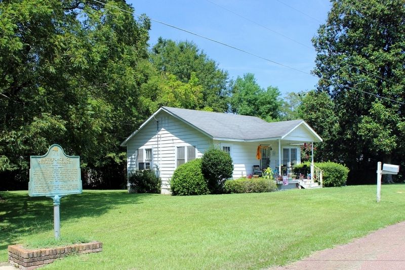
On Gerald McRaney Street at South Elm Avenue, on the right when traveling north on Gerald McRaney Street.
This native son, through his celebrity status as a television and motion picture actor, has brought recognition to this community. Because his life was shaped by his heritage, he returns to his grassroots each year to visit family and friends. This . . . — — Map (db m170481) HM
On North Fir Avenue 0.2 miles north of 4th Street North, on the left when traveling north.
Named for George Washington Carver, Carver
Central High School was built in 1956-1957 and
was Covington County's only high school for
African Americans. After completing the ninth
grade, students from Hopewell, Mt. Olive,
Seminary and . . . — — Map (db m312144) HM
On Lake Mike Connor Road at Yates Road, on the left when traveling south on Lake Mike Connor Road.
Covington County was established in 1819, and the county seat was located here in 1829. This courthouse square has been the site of three courthouses, built in 1829, 1854, and 1894. The last courthouse was burned by arson in 1904. After the county . . . — — Map (db m110966) HM
On Main Street (State Highway 184) at South Elm Avenue, on the left when traveling south on Main Street.
Constructed in 1907 after the county seat moved from Williamsburg, this building was added to the National Register of Historic Places in 1991.
Covington County was formed by an act of the State Legislature on January 5, 1819, and signed into . . . — — Map (db m149333) HM
On South Elm Avenue at Main Street (State Route 184), on the left when traveling south on South Elm Avenue.
Front
In honor of Covington County Veterans of the Vietnam War
Rear
In Memory of
James Russell Pope
Private First Class
2nd Bn. 16th Infantry, 1st Inf. Div. USARV
Collins, MS
Jan. 28, 1947 - July 27, . . . — — Map (db m111173) WM
On South Dogwood Avenue at Main Street (State Route 184), on the right when traveling south on South Dogwood Avenue.
Dedicated to the
men and women of the Armed Forces
who served their country in all wars
and to those who gave their lives
in defense of freedom — — Map (db m111175) WM
On South Main Street west of 7th Street, on the right when traveling west.
Guitarist, singer, and songwriter Billy Ray Reynolds
of Mount Olive arrived in Nashville in the 1970s, just
as the "outlaw" movement in country music was
beginning. He made his mark as bandleader for
Waylon Jennings and later by playing with . . . — — Map (db m312324) HM
On Willow Avenue just north of East Main Street, on the right when traveling north.
World War II 1941-45McGrew Aultman • Trinjton Ruffin Aultman • Earnest Arthur Clark • Kenneth Graham Davis • J. P. Dunn • Ulmer Fairchild • Van Barkley Hemeter • A. J. Kelly • Lawrence Alllen Lott • Charles Ross Pickering • Ira Bruce Redmon . . . — — Map (db m276599) WM
On U.S. 49 at State Route 590, in the median on U.S. 49.
East ¼ mile. Founded in 1846 as a coeducational boarding school by A.R. Graves, NY Presbyterian clergyman. Gave pre-law, pre-medical and fine arts training. Destroyed in the Civil War. — — Map (db m170485) HM
Created in 1911 by an act of the Mississippi Legislature, as an agricultural boarding school. Set on 320 acres of donated land. Students from across the United States, Mississippi and several foreign countries have been educated here. In 1996 FCAHS . . . — — Map (db m50077) HM
On Forrest Avenue West at Museum Street, on the left when traveling north on Forrest Avenue West.
442nd Regimental Combat Team
100th Infantry Battalion (separate)
S Co. Military Intelligence Service
171st Infantry Battalion (separate)
1943-1945
All of the units listed above were composed of Americans of Japanese ancestry. At the . . . — — Map (db m291684) WM
On Lee Avenue at 38th Street, on the left when traveling east on Lee Avenue.
From this site (Camp Shelby Field House), on April 18, 1942, WLW (700 AM) in Cincinnati began broadcasting the Camp Shelby Victory Salute radio program across the globe. The weekly programs were produced by Camp Shelby's public relations . . . — — Map (db m292573) HM
On Forrest Ave W at Museum Street on Forrest Ave W.
Camp Shelby became an early part of movie history when it was used as a filming location for the 1918 film The Spirit of the Red Cross. Starring silent film stars Raymond McKee and Claire Adams, the film was written and directed by the . . . — — Map (db m291427) HM
On Forrest Avenue West at Museum Street on Forrest Avenue West.
Dedicated to the soldiers of the 155th Brigade Combat Team that served honorably and proudly during operation Iraqi Freedom, Jan. 2005 - Jan. 2006
Reverse Side
155th Brigade Combat Team in Memoriam
MSG Sean M. Cooley, Co. B, . . . — — Map (db m292694) WM
On Forrest Ave W at Museum Street on Forrest Ave W.
Alabama • Florida • Louisiana • Mississippi Army National Guard
Dedicated to all who served their country so honorably and proudly in World War I • World War II • Korean Conflict — — Map (db m292355) WM
On Forrest Avenue West at Museum Street on Forrest Avenue West.
38th Division Organized Camp Shelby
25 August 1917
Served in Europe World War I
Mobilized 17 January 1941
Served in S.W. Pacific World War II
Dedicated to Those Who Served
Campaigns - Decorations
WWI Campaign Streamer
WWII . . . — — Map (db m292347) WM
On Forrest Ave W at Museum Street on Forrest Ave W.
Activated Aug. 16, 1943 at Camp Shelby
Trained Here to Jan. 3, 1945
Major Gen. Stanley E. Reinhart Commanding
Served in France, Germany and Austria
Jan. 22 - Aug. 31, 1945
Under XII and XX Corps.
Gen. Geo. S. Patton's 3rd Army . . . — — Map (db m292361) WM
On Forrest Avenue West at Museum Street on Forrest Avenue West.
Activated May 15, 1943 and trained for combat at Camp Shelby, Mississippi under the command of Major General Charles L. Bolte.
Embarked for combat duty under the command of Major General Emil F. Reinhardt.
Engaged the German forces at the . . . — — Map (db m292351) WM
On Forrest Avenue West at Museum Street, on the left when traveling north on Forrest Avenue West.
In memory of those Americans who served their nation as "Custermen" in World War II
Fifth Army, 1944-1945, Rome - Arno - North Apennines - Po Valley - activated at Camp Shelby on May 15, 1942
Custer Division
1942-1945 . . . — — Map (db m291678) WM
On Forrest Ave W at Museum Street, on the left when traveling north on Forrest Ave W.
The AH-1 was created from the need for a dedicated attack helicopter. Prior to its introduction, the Army used UH-1's that had been modified to fill the role of Arial Rocket Artillery (ARA). The AH-1 changed Close Air Support (CAS) for the . . . — — Map (db m291292) HM
On Forrest Ave W at Museum Street, on the left when traveling north on Forrest Ave W.
Boyevaya Mashina Pekhoty (BMP) is translated to "Combat Vehicle, Infantry." Ahead of its time, the BMP1 was the world's first truly mechanized infantry combat vehicle. For the first time, dedicated infantry units could fight from inside their . . . — — Map (db m291264) HM
Near West Forrest Avenue at Forrest Avenue, on the right when traveling west.
Following activation for service in both WWI and WWII, Ky. Guard units, as part of the 38th Inf. Div. were sent to Camp Shelby for training in preparation for war. Ky. National Guard units trained at Camp Shelby during WWI and WWII: 75th Brig.; . . . — — Map (db m71589) HM
On Forrest Ave W at Museum Street, on the left when traveling north on Forrest Ave W.
The CH-54 was at one time the US Army's largest helicopter. It had a ceiling of 6,900 feet and an operational range of 230 miles. During the Vietnam War, Tarhe cranes recovered more than 380 downed American aircraft which yielded a savings of . . . — — Map (db m291290) HM
On Forrest Ave W at Museum Street on Forrest Ave W.
Dedicated to all men and women wounded in all our wars
My stone is red for the blood they shed. The medal I bear is my country's way to show they care. If I could be seen by all mankind maybe peace will come in my lifetime. — — Map (db m291531) WM
On Jackson Ave W at Forrest Ave W, on the left when traveling north on Jackson Ave W.
In 1935, when Camp Shelby was chosen to be the permanent home of the Mississippi National Guard's training activities, construction began on the first structures that would make up the cantonment. The first one to be completed was the Dispensary . . . — — Map (db m292376) HM
On Forrest Ave W at Museum Street, on the left when traveling north on Forrest Ave W.
The photograph to the left shows State Representative Mac Huddleston of Pontotoc, MS, piloting a UH1 helicopter over the Saigon River in 1967 during his service as an Army Aviator in the Vietnam War. In the photograph Huddleston is landing to refuel . . . — — Map (db m291370) HM
On Forrest Ave W at Museum Street, on the left when traveling north on Forrest Ave W.
This arsenal building, or "ammo magazine," is the last surviving structure of over 1,200 built at Camp Shelby during World War I. Originally located ¼ mile southeast of its current site, just west of the World War I remount depot (stables), it was . . . — — Map (db m291260) HM
On Lee Avenue at 37th Street, on the left when traveling east on Lee Avenue.
These concrete buttresses and foundation are what remains of the World War II Field House at Camp Shelby. Constructed in late 1941, this indoor "sports arena" was built as part of the mobilization effort by the U.S. to expand facilities at Army . . . — — Map (db m292574) HM
On Forrest Ave W at Museum Street, on the left when traveling north on Forrest Ave W.
The First Marine Division is the oldest and most decorated Division size unit in the US Marine Corps activated February 1, 1942 aboard the Battleship USS Texas
Regiments -
1st - 5th - 7th - 11th
Major Campaigns and Interventions . . . — — Map (db m291501) WM
On Forrest Ave W at Museum Street, on the left when traveling north on Forrest Ave W.
Honoring all Mississippians who served in the Airborne Forces of the United States of America
Dedicated to the memory of those who will "stand in the door" no more
Reverse Side
Serving Then -
Serving Now — — Map (db m291513) WM
On Forrest Ave W at Museum Street on Forrest Ave W.
After the selection of Camp Shelby as the permanent home of the Mississippi National Guard's training activities, construction began in 1935 on the cantonment's first structures. This brick structure was the first of four identical latrines along . . . — — Map (db m291416) HM
On Forrest Ave W at Museum Street, on the left when traveling north on Forrest Ave W.
Equipped with a series of radical design changes, the M1 tank represented a marked departure from previous American tanks. The fire control system for its cannon was mounted with a laser rangefinder and thermal day/night sights for both the . . . — — Map (db m291372) HM
On Forrest Ave W at Museum Street, on the left when traveling north on Forrest Ave W.
Since the introduction of the tank in the First World War, infantry units have been vulnerable to tank attack. As more and more armor was added to tanks, traditional infantry weapons were rendered useless. To cope with this situation, anti-tank guns . . . — — Map (db m291251) HM
On Forrest Ave W at Museum Street on Forrest Ave W.
The M102 105mm howitzer is used in air mobile (helicopter) and light infantry operations. The weapon carriage is lightweight welded aluminum, mounted on a variable recoil mechanism. The M102 functions as a lightweight towed weapon that provides . . . — — Map (db m291423) HM
On Forrest Ave W at Museum Street, on the left when traveling north on Forrest Ave W.
The M103 heavy tank was produced during the Cold War as a direct response to Soviet heavy tank production. This massive vehicle was armed with a M58 rifled 120 millimeter cannon. The tank's large four-man turret facilitated two loaders, one gunner, . . . — — Map (db m291375) HM
On Forrest Ave W at Museum Street, on the left when traveling north on Forrest Ave W.
The first prototype of this howitzer was built in 1940 as a replacement for the French-designed field pieces still in use from the First World War. Built with a high-pressure monobloc (single piece construction) barrel, the design proved so . . . — — Map (db m291263) HM
On Forrest Ave W at Museum Street, on the left when traveling north on Forrest Ave W.
In the years immediately following the Second World War, army planners believed that mechanized forces should have a vehicle specialized to each of their branch missions. For the cavalry, a small, maneuverable, amphibious scout vehicle would empower . . . — — Map (db m291289) HM
On Forrest Ave W at Museum Street, on the left when traveling north on Forrest Ave W.
Designed by Colonel Francisco Elorza (director of the Royal Trubia Arsenal from 1844 to 1862), the first Spanish rifled cannon of this caliber was produced in August 1860: Referred to as a "Muzzle Loading Rifled" gun (MLR), the M1860 was made of . . . — — Map (db m291288) HM
On Forrest Ave W at Museum Street on Forrest Ave W.
The M19 is a derivative of the M24 Chaffee light tank. American designers made every attempt to employ a common automotive design that could be used for several different types of combat vehicles. In order for the M19 mount to work properly . . . — — Map (db m291418) HM
On Forrest Ave W at Museum Street, on the left when traveling north on Forrest Ave W.
The Grande Puissance Filloux is translated "gun of great power, designed by Filloux”. It saw use from both French and American armed forces during the First World War. Manufactured by the Saint-Chamond Company, the GPF was boasted as the only . . . — — Map (db m291258) HM
On Forrest Ave W at Museum Street, on the left when traveling north on Forrest Ave W.
After the First World War, the French Schneider howitzer was adopted by the U.S. Army as the M1918. Issued as the M1918A3, it had rubber tires (a marked improvement over wooden wheels). Additionally, air brakes were added for greater deceleration . . . — — Map (db m291255) HM
On Forrest Ave W at Museum Street, on the left when traveling north on Forrest Ave W.
This cannon was the most widely used and produced howitzer in the western hemisphere. More than 60 other nations use or have used the M2A1 (M101). Upon entering service just in time for the Second World War, it became the primary field piece for all . . . — — Map (db m291253) HM
On Forrest Ave W at Museum Street on Forrest Ave W.
After a long development period, the M26 finally went into production at the Fisher Tank Arsenal in Grand Blanc, Michigan in November 1944 at the cost of approximately $81,324 per tank. Ten T26E3 tanks were produced that month, thirty in December, . . . — — Map (db m291412) HM
On Forrest Ave W at Museum Street on Forrest Ave W.
After the Second World War, US army structure required a more effective light tank for the new Armored Cavalry Regiments (which would patrol the borders of the free world). The prototype of the M41 was completed in 1949 and was intended to be a more . . . — — Map (db m291411) HM
On Forrest Ave W at Museum Street on Forrest Ave W.
Because the M42 was used extensively in Vietnam, soldiers dubbed it the Duster because of the amount of dust that it kicked both in the firebases and in the target area. Having no radar, the M42 was a clear weather, anti-aircraft artillery piece . . . — — Map (db m291425) HM
On Forrest Ave W at Museum Street on Forrest Ave W.
Intended to replace the M46 tank, the M47 was itself replaced by the M48 tank shortly after entering service. As a result, many of the M47 tanks produced were sold to aid many other countries friendly to the United States during the Cold War. Early . . . — — Map (db m291410) HM
On Forrest Ave W at Museum Street on Forrest Ave W.
After the Second World War, the USSR turned its attention to spreading Communism around the world. One of their chief enforcement tools was the famous T-34/85 medium tank equipped with an 85 millimeter gun. During the Korean War hundreds of T-34's, . . . — — Map (db m291409) HM
On Forrest Ave W at Museum Street on Forrest Ave W.
At the time of its construction, the M4A1 featured the largest armor tank hull-casting in the world. This characteristic radically sped up tank construction time in comparison to riveting methods used previously. American Industry turned its might . . . — — Map (db m291413) HM
On Forrest Ave W at Museum Street on Forrest Ave W.
Derived from the M2A2 of 1936, the MS was the product of a string of modifications and improvements. After the M2A4 came the M3, M3 "Horseshoe" turret, M3E2, M3A1, M3A2, M3A3, and M3A1E1. After these, the army felt that the next model of light tank . . . — — Map (db m291414) HM
On Forrest Ave W at Museum Street on Forrest Ave W.
The M56 actually fills the role of a tank destroyer even though the Tank Destroyer Corps was abolished after the Second World War. Dubbed by troops a self-propelled anti-tank gun (SPAT), the M56 was sent into production partially in response to a . . . — — Map (db m291424) HM
On Forrest Ave W at Museum Street on Forrest Ave W.
The M578 was introduced to support the self-propelled howitzers available to the army in the 1960s. The M107, M109, and M110 (and all armored personnel carriers) were lighter than main battle tanks (MBT) by 20 or more tons. This weight difference . . . — — Map (db m291422) HM
On Forrest Ave W at Museum Street on Forrest Ave W.
The introduction of the M59 to the US Army provided the infantry with its first fully amphibious armored personnel carrier (APC). The interior of an APC was large enough to transport a jeep and it featured an M19 infrared driver's night vision . . . — — Map (db m291421) HM
On Forrest Ave W at Museum Street, on the left when traveling north on Forrest Ave W.
Eight years after the M48 tank entered production, improvements in available technology coupled with the Soviet Union's deployment of the 100 mm gun-equipped T55 main battle tank mandated the need to design a new American up-gunned tank. In addition . . . — — Map (db m291373) HM
On Forrest Ave W at Museum Street on Forrest Ave W.
An excellent example of American design potential, the M7 served to drastically change artillery soldiers' contributions to mobile warfare. The M7 could drive up to a firing position, establish reference points, and be ready for indirect fire . . . — — Map (db m291415) HM
On Forrest Ave W at Museum Street, on the left when traveling north on Forrest Ave W.
On a battlefield where cannon projectiles could be launched at speeds of more than a mile per second, troops asked to perform combat engineering tasks such as the removal and installation of obstacles under fire were issued the M728 Combat Engineer . . . — — Map (db m291374) HM
On Forrest Ave W at Museum Street on Forrest Ave W.
The US Army needed a modern armored personnel carrier (APC) to replace the M3 Halftrack which dated back to the 1930s. Development of the M75 began in September of 1946 as the T18. Adopted in 1952 as the M75, It was the first armored troop carrier . . . — — Map (db m291419) HM
On Forrest Ave W at Museum Street on Forrest Ave W.
Dedicated to the memory of the soldiers and service personnel supporting and training for service in the Global War against Terrorism.
Organized at Camp Shelby
07 June 2004
Praemitto Pro Patria
Reverse Side
US Conflicts . . . — — Map (db m291518) WM
On Forrest Ave W at Museum Street, on the left when traveling north on Forrest Ave W.
Mashina Transportnaya Legkaya Boyevaya is translated "Vehicle, Transport, Light, Combat." The MTLB was developed to fill the modern utility needs for a mechanized army. Built in Russia, the MTLB became the Soviet's armored prime mover for a . . . — — Map (db m291262) HM
On Lee Avenue at 37th Street, on the right when traveling east on Lee Avenue.
When Camp Shelby's pre-World War II mobilization construction began in late 1940, the Non-Divisional Service Club Area was intended to be its main service hub. It contained Service Club No. 2, Theater No. 3, Field House, Main Post Office, Signal . . . — — Map (db m292576) HM
On Forrest Ave W at Museum Street, on the left when traveling north on Forrest Ave W.
Even today, the OH-6 is seen as one of the most compact manned military aircraft in history. Weighing less than one ton, the Cayuse could carry four men, two of which could be offloaded into combat. It could also carry a wide range of weapons. Early . . . — — Map (db m291371) HM
On Forrest Avenue West at Museum Street, on the left when traveling north on Forrest Avenue West.
Mobilized 15 October 1940 trained at Camp Shelby through Feb 1942 reorganized and members served in all theaters of operation.
Major General Robert S. Beightler Commander
Div Staff •
147th Inf. •
135th Field Art. •
Spc. Troops • . . . — — Map (db m291685) WM
On Forrest Ave W at Museum Street, on the left when traveling north on Forrest Ave W.
The OV-1 was built as a multi-sensor tactical observation reconnaissance aircraft. As part of the OV-1's standard configuration, it was outfitted with high quality cameras and upward-firing illumination flare launchers for day and night photography . . . — — Map (db m291267) HM
On Lee Avenue at 37th Street, on the right when traveling east on Lee Avenue.
Before you are the concrete foundational remains of Camp Shelby's Service Club No. 2, better known during World War II as the "Non-Divisional Service Club." One of several facilities built at Camp Shelby as part of the 1940 pre-World War II . . . — — Map (db m292577) HM
On Forrest Avenue West at Museum Street on Forrest Avenue West.
Dedicated to the members and families of the 2nd Battalion 20th Special Forces Group (Airborne)
Mississippi Army National Guard
Our Fallen Brothers
SFC Christopher L. Robinson, 25 Mar 2006 •
SFC Severin W. Summers, . . . — — Map (db m292704) WM
On Forrest Ave W at Jackson Ave W, on the left when traveling west on Forrest Ave W.
In 1935, when Camp Shelby was selected to be the permanent home of training activities for the Mississippi National Guard, construction soon began on several permanent buildings on the site of the camp's former World War I base hospital. One of the . . . — — Map (db m292374) HM
On Lee Avenue at 37th Street, on the right when traveling east on Lee Avenue.
These are the foundational remains of Theater No. 3, one of six permanent type theaters constructed at Camp Shelby during World War II. Also known as the "Non-Divisional Theater," it replaced an earlier tent theater that stood on the same footprint. . . . — — Map (db m292575) HM
On Forrest Ave W at Museum Street, on the left when traveling north on Forrest Ave W.
Sovereign God. May your eternal grace,
bless all who have come this way,
to honor fallen comrades in this place,
may your love and spirit hold sway.
O my lord, we consecrate this token,
in honor of chivalrous men who gave . . . — — Map (db m291521) WM
On Forrest Ave W at Museum Street, on the left when traveling north on Forrest Ave W.
The UH-1, nicknamed "Huey," introduced the concept of air mobility warfare. Using the UH-1 as a flying truck, the US Army discovered that it could move massive amounts of material and large numbers of troops over foreboding terrain and enemy lines. . . . — — Map (db m291291) HM
On Jackson Avenue at 21st Street, on the left when traveling east on Jackson Avenue.
At this site stood the Camp Shelby Vaudeville Theatre during World War I. Operated privately as a concession theater by the Shelby Amusement Company, Inc., it was constructed entirely of lumber in 1917. Vaudeville acts, plays, musical shows, and . . . — — Map (db m292572) HM
On Forrest Ave W at Museum Street, on the left when traveling north on Forrest Ave W.
Zenitnaya Samokhodnaya Ustanovka is translated "anti-aircraft self-propelled (gun) mount”. During the 1960s, air mobility concepts were beginning to take hold in first world nations. Once again, Soviet armament designers were ahead of the . . . — — Map (db m291265) HM
On Elks Lake Road at Dixie Barn Road on Elks Lake Road.
Citizens of the Dixie community built this structure 1/4 mile southeast of this site in the 1930s to serve as a cafeteria during the Depression era. The log cabin has also served as a meeting place, music hall and classroom. In 2003 the cabin was . . . — — Map (db m56534) HM
On Spencer Street at Milton Barnes Avenue, on the right when traveling north on Spencer Street.
On this site stood the old Mount
Zion Baptist Church, demolished in
1993. Known locally as "The Cvil
Rights Church", the church hosted
a "Freedom School” in 1964 and
many mass meetings during the
Civil Rights Movement. Dr. . . . — — Map (db m118478) HM
On Mobile Street near Fifth Street, on the right when traveling north.
There is no place you or I can go, to think about or not think
about, to summon the presences of, or recollect the absences of
slaves; nothing that reminds us of the ones who made the journey
and of those who did not make it. There is no . . . — — Map (db m175887) HM
On Bonhomie Road 0.2 miles south of W.S.F. Tatum Boulevard, on the left when traveling south.
These buildings are the remnants of
Bonhomie, a company-owned sawmill town
that thrived from 1915 to 1938. The Tatum
Lumber Company established a mill here
in 1915, drawing laborers and their
families to the area. During its height,
Bonhomie . . . — — Map (db m175897) HM
Near East Memorial drive south of Smalling Drive, on the right when traveling north.
Forrest County native Clyde Kennard was a pioneer in the quest to desegregate higher education in Mississippi. His efforts to enroll at Mississippi Southern College (now USM) in 1955-1959 were obstructed by college president William D. McCain and . . . — — Map (db m118838) HM
On Crestmont Avenue south of West Arlington Loop, on the right when traveling south.
Born and raised in Hattiesburg. Craig Wiseman
began his extraordinary music career here before
moving to Nashville, Tennessee, where he became
one of country music's most prolific and celebrated
songwriters and a successful music . . . — — Map (db m284575) HM
On Southern Mississippi Drive east of North 31st Street, on the left when traveling east.
The Mississippi Normal College,
now the University of Southern
Mississippi, was established in 1910.
The Demonstration School opened in
1926 during the time when the college
was called the State Teachers College
(1924-1940). The school taught . . . — — Map (db m118399) HM
Sisters Dorie and Joyce Ladner were community
leaders during the civil rights movement. As
teenagers, they joined the NAACP Youth Council
and the Student Nonviolent Coordinating Committee
and were mentored by civil rights leaders . . . — — Map (db m273662) HM
On East Sixth Street west of New Orleans Street, on the left when traveling west.
The East 6th Street USO Club was built
in early 1942 under the umbrella of the
United Services Organization (USO).
This T-shaped, wood-frame building
included an auditorium, stage, lobby,
restrooms, dressing rooms, and meeting
rooms. Built for . . . — — Map (db m118393) HM
On East Sixth Street west of Mobile Street, on the right when traveling west.
This building, opened in 1921, under the leadership of W.H. Jones, was one of the first modern brick schools in Miss. for blacks. Its alumni have served the state and nation with distinction. — — Map (db m118458) HM
On Monroe Road 0.1 miles north of Travis Road, on the left when traveling north.
The home of Evelyn Gandy (1920-2007) was built
ca. 1905. Born in Hattiesburg, she attended
the University of Southern Mississippi and
graduated from the University of Mississippi
School of Law in 1943. In 1947, Gandy was
elected to the House . . . — — Map (db m312140) HM
On North Main Street at Eaton Street, on the right when traveling south on North Main Street.
[Northeast Inscription]:
C.S.A.
To the Men and Women of
the Confederacy
1861-1865
[Southwest Inscription]:
When their county called
they held back nothing.
They cheerfully gave their
property and their lives.
. . . — — Map (db m39867) WM
On Hardy Street at East Pine Street (U.S. 11), in the median on Hardy Street.
[West Side]
Formerly Choctaw Territory and later claimed by France, Britain, Spain and United States, this area entered by settlers in early 1800s and known as Ewin Forks, later Gordonville. Chosen as rail center by Captain William H. . . . — — Map (db m58885) HM
On Old Airport Road at North Hattiesburg Avenue, on the left when traveling east on Old Airport Road.
The Hi-Hat Club, which was built at this site in the 1950s, was once an important stop on the “chitlin circuit” for African American blues and soul performers. B. B. King, James Brown, Otis Redding, Ike & Tina Turner, and many others played to . . . — — Map (db m118467) HM
On Mobile Street north of Fifth Street, on the right when traveling north.
Named for grocer, hotel owner-operator, community leader. Republican 6th Cong. District. Chairman 1924-1940. National Convention Delegate 1936. Leader of Black MS Republicans 1920-1940. ------------------------------------------------------- Wood . . . — — Map (db m175992) HM
On Broadway Drive (U.S. 11) at Richburg Road, on the right when traveling south on Broadway Drive.
Defeated Jake Kilrain for
heavyweight championship
in a 75 round fight on
July 8, 1889, at Richburg,
3 miles southwest of this
spot. This was the last
official bare-knuckle bout. — — Map (db m175891) HM
Kenneth Fairley, born December 30, 1953, emerged as a powerful voice and community activist following the Civil Rights
Movement of the 1960s, advocating fiercely for the rights of African Americans in Hattiesburg and surrounding . . . — — Map (db m273628) HM
On Southern Miss Drive at Forrest Avenue, on the left when traveling west on Southern Miss Drive.
Born in Leaf, Mississippi, in 1937, Lloyd Lamar Green established the steel guitar as a signature melodic voice in country music while performing on thousands of songs. Green played on 116 No. 1 country music hits, including Tammy Wynette’s . . . — — Map (db m274999) HM
On North Main Street (U.S. 11) at McLeod Street, on the right when traveling south on North Main Street.
This Property
has been placed on the
National Register
of Historic Places
by the United States
Department of the Interior
McLeod House
1897 — — Map (db m39904) HM
On William Carey Parkway 0.5 miles east of U.S. 49, on the left when traveling east.
The Mount Olive Cemetery was
established in 1906 as a burial ground
for employees of the Tatum Lumber
Company and for the Bonhomie community.
W.S.F. Tatum, founder of the mill and
a future mayor of Hattiesburg, donated
$100 to purchase a . . . — — Map (db m206616) HM
On West Pine Street (U.S. 11) at Forrest Street on West Pine Street.
[Right Plaque]:
This Building, the
Old Federal Building
has been listed on the
National Register of Historic Places
by the
U.S. Department of Interior
September 1973
• • •
Supervised by architect James Knox Taylor, this . . . — — Map (db m44961) HM
On North Main Street at College Street, on the left when traveling north on North Main Street.
Under the direction of Principal J.T. Wallace, this building was Hattiesburg's High School from 1922 to 1959. Built in 1911, the structure acquired its present form when enlarged and remodeled in 1921 to the designs of Robert E. Lee, the city's . . . — — Map (db m39906) HM
On South 28th Avenue at Pinehills Drive, on the right when traveling south on South 28th Avenue.
Established in 1935 during the
Great Depression and known as
Hattiesburg Homestead. Originally
had 25 small farms, each having a
standardized house, fruit trees,
and outbuildings. Some original
buildings still stand. Large lots,
abundant . . . — — Map (db m243148) HM
On East Pine Street north of Mobile Street, on the left when traveling north.
The land for Pittman Park was purchased by former Mayor Bobby L. Chain
and given to the City of Hattiesburg for the use of its citizens. This gift is in honor and memory of the only father-son mayor combination in the history of Hattiesburg, . . . — — Map (db m119150) HM
On Eatonville Road 0.5 miles west of J.C.Bryant Road, on the left when traveling west.
Organized October 3, 1818.
First pastor,
Norvell Robertson, was a
Revolutionary soldier.
Eight charter members were
of the Granberry, Robertson
and Lee families. — — Map (db m175734) HM
On Mobile Street near East 5th Street, on the right when traveling north.
Rev. W.D. Ridgeway was one of the most courageous, steadfast and respected
Civil Rights Leaders to emerge in Mississippi during the 1950s. He was
constantly under the radar of the Mississippi State Sovereignty Commission
and the local White . . . — — Map (db m191866) HM
237 entries matched your criteria. The first 100 are listed above. Next 100 ⊳