51 entries match your criteria.
Entries Containing All of the Phrases «st johns county» AND «florida»
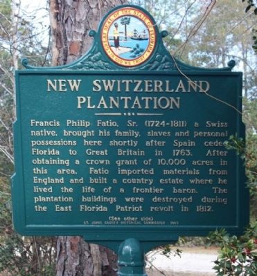
By Mike Stroud, December 2, 2012
New Switzerland Plantation Marker
RANKED BY RELEVANCE
1 ► Florida, St. Johns County, Switzerland — St. Johns County / New Switzerland Plantation —  |
| On State Road 13 near Swiss Lane, on the right when traveling north. | |||
| 2 ► Florida, St. Johns County, St. Augustine — The Powder House Lot / St. Johns County — |
| On Marine Street 0.1 miles south of Hedrick Street, on the right when traveling south. | |||
| 3 ► Florida, St. Johns County, St. Augustine — F-555 — Vilano Beach Casino — (1926-1939) — |
| On Vilano Road at Ferrol Road, on the left when traveling south on Vilano Road. | |||
| 4 ► Florida, St. Johns County, St. Augustine — F-478 — Zora Neale Hurston — |
| On West King Street near North McLaughlin Street, on the right when traveling east. | |||
| 5 ► Florida, St. Johns County, Ponte Vedra Beach — F-513 — Governor Grant's Plantations — |
| Near Guana River Road 0.2 miles west of South Ponte Vedra Boulevard (State Road A1A), on the right when traveling west. | |||
| 6 ► Florida, St. Johns County, St. Augustine — Treaty of Moultrie Creek — |
| Near Wildwood Drive north of Wild Oak Drive. | |||
| 7 ► Florida, St. Johns County, St. Augustine, Historic District — F-729 — Orange Street School — |
| On Orange Street east of Sevilla Street, on the right when traveling west. | |||
| 8 ► Florida, St. Johns County, St. Augustine — F-594 — Sanksville Cemetery — |
| On Joe Ashton Road 0.1 miles south of County Road 208, on the left when traveling south. | |||
| 9 ► Florida, St. Johns County, Vilano Beach — Allen D. Nease — |
| Near Coastal Highway (Florida Route A1A) 0.1 miles north of Gardner Street. | |||
| 10 ► Florida, St. Johns County, Butler Beach — Butler's Beach — |
| Near Florida Route A1A just south of Rudolph Street. | |||
| 11 ► Florida, St. Johns County, Elkton — F-512 — St. Ambrose Parish — |
| On Church Road 0.3 miles east of Winfred Masters Road, on the right when traveling east. | |||
| 12 ► Florida, St. Johns County, Fruit Cove — F-553 — Beluthahatchee — (Miccosukee, "Dark Water") — |
| On Cricket Hollow Lane (State Road 13) near Wedgewood Road, on the right when traveling north. | |||
| 13 ► Florida, St. Johns County, Picolata — F-86 — Picolata — "Pass Of The Salamatoto River" — |
| On County Road 13 at Picolata Road (County Road 208), on the left when traveling east on County Road 13. | |||
| 14 ► Florida, St. Johns County, Ponte Vedra Beach — F-554 — Palm Valley — |
| On Canal Boulevard 0.1 miles east of Roscoe Boulevard South, on the left when traveling east. | |||
| 15 ► Florida, St. Johns County, St. Augustine — F-595 — Evergreen Cemetery — |
| On North Rodriguez Street south of Pearl Street, on the left when traveling north. | |||
| 16 ► Florida, St. Johns County, St. Augustine — F-110 — Sentinels of the Coast — |
| On Red Cox Drive, on the right when traveling north. | |||
| 17 ► Florida, St. Johns County, St. Augustine — F-351 — The Segui-Kirby Smith House — |
| On Aviles Street at Artillery Lane, on the right when traveling south on Aviles Street. | |||
| 18 ► Florida, St. Johns County, St. Augustine — F-337 — Treaty Park — |
| Near Wildwood Drive north of Wild Oak Drive, on the left when traveling north. | |||
| 19 ► Florida, St. Johns County, St. Augustine, Historic District — F-111 — Mission Nombre de Dios — |
| On North Ocean Boulevard (State Road A1A) at Old Mission Avenue, on the right when traveling north on North Ocean Boulevard. | |||
| 20 ► Florida, St. Johns County, Summer Haven — F-85 — Massacre of the French — Matanzas Inlet — |
| On North Ocean Boulevard (State Road 1A), on the right when traveling south. | |||
| 21 ► Florida, St. Johns County, Vilano Beach — F-556 — Surfside Dance Hall and Bathhouse — |
| On North Ocean Boulevard (State Road A1A) at Surfside Avenue, on the right when traveling north on North Ocean Boulevard. | |||
| 22 ► Florida, St. Johns County, Green Cove Springs — F-514 — William Bartram's Plantation — |
| On State Road 16 0.8 miles west of State Road 13 (State Road 13), on the right when traveling east. | |||
| 23 ► Florida, St. Johns County, St. Augustine — Clerk of Court’s Office — Secretario De La Corte — |
| On King Street (Business U.S. 1) at St. George Street, on the left when traveling east on King Street. | |||
| 24 ► Florida, St. Johns County, Jacksonville — Welcome to Beluthahatchee Park — "A place where all unpleasantness is forgiven and forgotten." — |
| On State Road 13 North. | |||
| 25 ► Florida, St. Johns County, St. Augustine Beach — St. Johns County Black Heritage Trail — |
| Near A1A Beach Boulevard 0.1 miles north of 16 Street, on the right when traveling north. | |||
| 26 ► Florida, St. Johns County, St. Augustine, Anastasia — Meldrim Cottage — |
| On Coquina Avenue just north of Arricola Avenue, on the right when traveling south. | |||
| 27 ► Florida, St. Johns County, St. Augustine, Anastasia — F-229 — Old Spanish Quarries — (Anastasia Island) — |
| Near Park Road 0.1 miles east of Anastasia Boulevard (Road A1A). | |||
| 28 ► Florida, St. Johns County, Ponte Vedra Beach — F-326 — World War II Operation Pastorius / St. Johns County — Nazi Saboteurs Landed Here — |
| On Ponte Vedra Blvd. (State Road 203), on the right when traveling north. | |||
| 29 ► Florida, St. Johns County, St. Augustine Beach — 21st Century — St. Johns County Black Heritage Trail — |
| Near A1A Beach Boulevard 0.1 miles north of 16th Street, on the right when traveling north. | |||
| 30 ► Florida, Monroe County, Key West — John Watson Simonton — 1789 - 1854 — Key West Historic Memorial Sculpture Garden — |
| Near Wall Street at Tift’s Aly. | |||
| 31 ► Florida, St. Johns County, Hastings — F-1262 — The Wetumpka Fruit Company — |
| On Hastings Boulevard at Leonard Road, on the left when traveling south on Hastings Boulevard. | |||
| 32 ► Florida, St. Johns County, Jacksonville, Saint Johns — The Golf Capital of the World — Florida Department of Transportation — |
| On Interstate 95 0.3 miles south of Race Track Road, on the right when traveling north. | |||
| 33 ► Florida, St. Johns County, St. Augustine — F-521 — The Old St. Johns County Jail — |
| Near San Marco Avenue (Business U.S. 1) 0.1 miles south of May Street (State Road A1A), on the left when traveling south. | |||
| 34 ► Florida, St. Johns County, St. Augustine — William Bartram Trail — Traced 1773-1777 — Deep South Region — |
| Near Anastasia Boulevard (State Highway A1A) 0.1 miles south of Madeira Drive, on the left when traveling south. | |||
| 35 ► Florida, St. Johns County, St. Augustine — Welcome to Hiram Faver Trail — Faver-Dykes State Park — |
| Near Favor-Dykes Road 3 miles east of Dixie Highway (U.S. 1). | |||
| 36 ► Florida, St. Johns County, St. Augustine, Saint Johns — Castillo De San Marcos — |
| On Interstate 95 (at milepost 302) west of County Route 206, on the left when traveling north. | |||
| 37 ► Florida, Brevard County, Titusville — F-261 — Douglas Dummett - Dummett Grove — |
| On Courtenay Parkway North (State Road 3) 0.3 miles north of Biolab Road, on the left when traveling north. | |||
| 38 ► Florida, Escambia County, Pensacola — Transfer of Spanish Florida to the United States — Florida's Territorial Bicentennial — |
| Near Zaragoza Street east of South Jefferson Street, on the left when traveling east. | |||
| 39 ► Florida, St. Johns County, St. Augustine — The Lynching of Isaac Barrett / Racial Violence in America — Community Remembrance Project — |
| On Cordova Street north of Orange Street, on the right when traveling north. | |||
| 40 ► Florida, St. Johns County, Ponte Vedra — Cattle Ranching — |
| On Davis Park Road 1 mile south of County Route 210, on the left when traveling south. | |||
| 41 ► Florida, St. Johns County, St. Augustine — Cordova Hotel/County Courthouse |
| On Cordova Street at King Street (Business U.S. 1), on the right when traveling north on Cordova Street. Reported missing. | |||
| 42 ► Florida, St. Johns County, Switzerland — History of Alpine Groves Park — |
| Near Florida Route 13 just south of Swiss Lane. | |||
| 43 ► Florida, St. Johns County, St. Augustine — San Lorenzo Cemetery Civil War Memorial — |
| Near Old Moultrie Road (County Route 5A) at Cemetery Road, on the right when traveling north. | |||
| 44 ► Florida, Flagler County, Bunnell — Moody Homestead Park — |
| Near Briarwood Drive 0.1 miles west of Old Brick Road, on the right when traveling west. | |||
| 45 ► Florida, St. Johns County, St. Augustine — F-323 — Tovar House — |
| On St Francis Street at Charlotte Street, on the right when traveling west on St Francis Street. | |||
| 46 ► Florida, St. Johns County, St. Augustine, Historic District — Down on the Farm — Old Town St. Augustine — |
| Near San Marco Avenue at Dufferin Street, on the left when traveling south. | |||
| 47 ► Florida, St. Johns County, St. Augustine, Historic District — Potter’s Field — Old Town St. Augustine — |
| On San Marco Avenue at Dufferin Street, on the left when traveling south on San Marco Avenue. | |||
| 48 ► Florida, Duval County, Jacksonville Beach, The Beaches — Coastal Weather — |
| Near 1st Street South (Ocean Front Street) just south of 5th Avenue South, on the right when traveling north. | |||
| 49 ► Florida, St. Johns County, St. Augustine — World War II Memorial — St. Johns Country. Florida — |
| On Cathedral Plaza at Charlotte Street, on the left when traveling west on Cathedral Plaza. | |||
| 50 ► Florida, St. Johns County, St. Augustine Beach — Recreation and Fun — St. Johns County Black Heritage Trail — |
| On A1A Beach Boulevard 0.1 miles north of 16th Street, on the left when traveling east. | |||
| 51 ► Florida, St. Johns County, St. Augustine Beach — Time of Transition — St. Johns County Black Heritage Trail — |
| On A1A Beach Boulevard 0.1 miles north of 16th Street, on the left when traveling east. | |||
Thin black lines indicate changes in relevance. Between each pair of lines entries are ordered geographically but all have the same relevance.
* Inflectional forms of words are their plurals, singulars, and possessives as well as gramatical tenses and similar variations.
Nov. 13, 2026