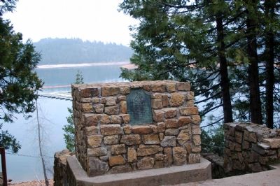
Honoring Walter E. Jenkinson, our fellow citizen who dedicated his life to this project which brought water to our city and fertile lands. — — Map (db m851) HM
"Traveled to the South Fork, here is a trading post and bridge, they charged 50¢ for a man and a horse,...we would not pay toll but forded, verry [sic] bad ford, went up a long mountain through the brush" - William Perry Hampton, Sep 13, 1852 — — Map (db m212509) HM
"We came to what is called Peavine Hill, and found a long steep descent, but we got down without difficulty, and nooned near an excellent spring (Granite Springs)"
J. Robert Brown, Sep 30, 1856 — — Map (db m212527) HM
"We came on over a ridge or backbone; the road is now much traveled, and is very dusty; the earth is very red and dry; the road is well worked here, for they haul much ice along here to Hangtown." - J. Robert Brown, Oct 2, 1856 — — Map (db m212524) HM
"The scenery is magnificent but it would be some task to come over these mountains with wagons. We saw any amount of grizzly bear tracks today." - George Washington King, June 6, 1853 — — Map (db m212523) HM
"To the fork of the road leading to Wever Town & Hangtown here we took the Hangtown Road it being the best thence to water on the left of road. Good grass one mile to right of road." Seth Lewelling, Aug 3, 1850 — — Map (db m212440) HM
"Started over the mountains again. Drove...over the [most] dusty roads we have ever saw since we left home. Camped about 6 in the evening at the Sportsmans Hall." - Abbey E. Fulkerth, Aug 3, 1863 — — Map (db m212443) HM
By the end of the war with Mexico in 1847, California’s non-native population was a mere 15,000. The 49ers pushed the population of El Dorado County beyond 20,000 by 1850. As winter approached, the minors replaced their tents and shanties with . . . — — Map (db m94634) HM
This was the site of Sportsman’s Hall, also known as Twelve-Mile House. The hotel operated in the late 1850’s and 1860’s by John and James Blair, a stopping place for stages and teams of the comstock. It became a relay station of the Central . . . — — Map (db m609) HM
The California gold rush followed Captain John Sutter’s logging effort in the Coloma valley. On January 24, 1848, James W. Marshall found gold in the tail-race at Sutter’s Mill. This discovery incited the greatest migration of mankind in history to . . . — — Map (db m94635) HM
Before the Gold Rush these lands were home to the Miwok (Mewuk) and Maidu (My-due) tribes. Summer camps and villages were scattered throughout the area. The Miwok village of CHU'NI, also known as TGON'O by local Maidu, is today inundated by the . . . — — Map (db m261813) HM
Shortly after James W Marshall discovered gold at Sutter's Mill, his Mormon laborers were re-called to the Great Salt Lake Valley, Utah. On April, 9, 1848, a plan was devised to cut a wagon trail through the uncharted Sierra Nevada frontier. The . . . — — Map (db m94636) HM
The Pony Express originated in 1860, when our nation was divided and civil war threatened. Communication between California and Washington DC took months. Although the Pony Express existed little more than 18 months, it played a major role in the . . . — — Map (db m94642) HM
With the discovery of gold on January 24, 1848, Coloma Road became one of the primary routes to the gold fields of El Dorado County. The road started at Sutter’s Fort (New Helvitia), then proceeded to Willow Springs (near Folsom), Mormon Island, . . . — — Map (db m11282) HM
Past this point on the Old Coloma Road, running between Sutter’s Fort and his sawmill on the American River, James W. Marshall rode with the first gold discovered at Coloma on Jan. 24, 1848. Traveled by thousands to and from the diggings, this road . . . — — Map (db m11268) HM
On this site the Boston-Newton Joint Stock Association encamped on September 26, 1849. The company left Boston April 16 and arrived at Sutter’s Fort September 27. After a remarkable journey across the continent a rich store of written records . . . — — Map (db m11568) HM
Dedicated July 1, 2000
Du Roc House
Added Station
July 1, 1861 – Nov. 20, 1861
by
PW Pipe
James Stretesky
Norman & Ann Root
County of El Dorado
American Suzuki Motor Corporation
Pony Express Trail . . . — — Map (db m50321) HM
This was the site of a popular roadhouse, where the ponies of the Central Overland Pony Express were changed during July 1, 1860 to June 30, 1861. From here the route of the pony riders continued westward to Folsom and eastward through Rescue, Dry . . . — — Map (db m10442) HM
The Josephine Mine was an integral part of the 1849 California Gold Rush and remained in operation until 1937. This cemetery is the final resting place of some of the pioneers that forged the western frontier and veterans of early American wars. The . . . — — Map (db m67644) HM
"Traveled six miles down Eubah then took to the left over the mountain passed a lake on our left on top of the mountain [Crystal Lake] drove ... to a valley on our left [Six Mile Valley] and encamp" - William P. Thompson, Aug 28, 1850 — — Map (db m149761) HM
History
Today people travel swiftly along I-80 to their destinations in the Sierra, many times not even staying overnight. When they do stay overnight it is most likely in hotels or rental houses.
It was not always that way. Before I-80 . . . — — Map (db m81970) HM
History
Love - Excitement - Pathos - Humor. It’s all in “The Gold Rush” which was filmed at Sugar Bowl (and Truckee).
“The Gold Rush,” written, produced, directed, and starring Charlie Chaplin was one of . . . — — Map (db m81934) HM
History
Clair Tappaan Lodge was hand-built by a hearty group of Sierra Club volunteers in 1934 as a retreat for hikers, skiers and mountain climbers. This rustic building, consisting of post and beam construction, was designed by Walter . . . — — Map (db m129660) HM
Dedicated to the pioneers who blazed the
Overland Trail through these mountains.
Built by the U.S. Bureau of Public Roads and the California Highway Commission
1925-1926.
This tablet placed by the Historic Landmarks Committee of the . . . — — Map (db m94763) HM
History
“I don’t believe I have adequate words to describe the real beauty of Donner Pass. As we stood looking down I had a floating sensation… I lost all fear as I looked at one of the most beautiful blue lakes (Donner Lake) I have . . . — — Map (db m81894) HM
Beneath this plaque the first transcontinental railroad traversed the mighty Sierra Nevada range. The 1659 foot long summit tunnel took over 15 months of Chinese muscle and sweat to build. The Chinese painstakingly hand drilled, then blasted the . . . — — Map (db m95506) HM
Dedicated August 10, 1986 in honor of
Charles Fayette McGlashan
1847-1931
Truckee’s patriarch, historian, author, editor, attorney, legislator, inventor, entomologist and astronomer.
His last public address was given in 1926 at . . . — — Map (db m81893) HM
"If only the Sierra might be pierced." Atlantic Monthly December, 1867
History
"Crazy Judah." Theodore Judah had some strange ideas. He wanted to build a railroad across the continent. People knew it could not be done. The . . . — — Map (db m105198) HM
History
“new addition… modern design… large new ski hut… semi-rustic design… oiled pine walls … ideally suited to skiers’ requirements… central heating… Norden awaits the opening of the winter sports season.” So advertised . . . — — Map (db m81875) HM
History
The Washoe Tribe lived on the eastern face of the Sierra Nevada mountains for more than 6,000 years. They didn’t actually call themselves the Washoe Tribe, though. They called themselves the Waashiw (Wa-she-shu) tribe, meaning . . . — — Map (db m81899) HM
History
The bridge “eliminated for all time the terrors of the Donner grade from the state highway system of California.”
Automobile travel could be a harrying affair in the old days and Donner Summit was a difficult route. . . . — — Map (db m81898) HM
The rocks here are carved with ancient symbols called petroglyphs.
They were created by pecking the surface of the rock with a tool called a hammerstone. These petroglyphs are thought to be several thousand years old. — — Map (db m81931) HM
History
When Bill Klien, who would transform skiing himself, invited Hannes Schroll to Donner Summit from Yosemite in 1937, the ski industry was about to change. Hannes was a dare-devil champion skier whose yodels as he tore down mountains . . . — — Map (db m81933) HM
History
The current building at the head of Donner Pass on Old 40 was built for the Division of Highways in 1931 to serve as a dormitory for highway workers. That was the first winter the road was plowed and on-call workers needed . . . — — Map (db m81881) HM
History
The coming of the railroad made it easy for well-heeled tourists to visit Donner Summit and with the building of a large hotel, they came. Whole families came to enjoy the summit and stay for weeks at a time.
The first Summit . . . — — Map (db m81880) HM
History
Summit Valley has been the scene of human activity for thousands of years because it is a natural crossing of the Sierra. Native Americans traveled the valley moving from winter to summer residences. They left grinding rocks and . . . — — Map (db m81971) HM
History
William Wilson Wurster was the most “influential unknown architect in California.” He designed many houses and buildings such as Ghirardelli Square, Cowell College at UC Santa Cruz, as well as other U.C. and Stanford . . . — — Map (db m81939) HM
History
The ritual of arriving in early morning by train and taking the 15 minute ride in tractor drawn sleighs was in place for more than ten years after Sugar Bowl opened in 1939. It was the only way to get to Sugar Bowl. It was a cold . . . — — Map (db m81936) HM
History
Theodore Judah, who plotted the Central Pacific’s route over the Sierra and for whom Mt. Judah was named, thought it was only the mountains that needed conquering as the Central Pacific headed east to meet up with the Union Pacific. He . . . — — Map (db m81977) HM
History
It was a race. The Union and Central Pacific Railroads were crossing the continent with steel rails each trying to build the most miles and so get the most money from the government. The rugged Sierra and its winter climate were . . . — — Map (db m81883) HM
History
Because there were three lodges built on Forest Service land in the early 1930’s, they have always been referred to as the Tri-Lodges. The first of the three lodges built was der Naturfreund in 1931 (right). This is a private lodge . . . — — Map (db m81969) HM
History 1866 - Right here
Bam, bam, quarter turn; Bam, bam, quarter turn; Bam, bam, quarter turn; all day long, three shifts a day, day after day, week after week. Chinese workers pounded away at the solid granite. One worker held a star . . . — — Map (db m81878) HM
Home of the Festival of Arts and Pageant of the Masters. The originator was Laguman John Hinchman. The first living pictures were presented in 1933 as The Spirit of the Masters Pageant. The Festival of Arts Association was formed in September, 1934 . . . — — Map (db m121908) HM
This building served the people of Auburn and Placer County for more than 90 years as both a passenger and freight station.
The railroad track adjacent to this historic building is the original route location for the transcontinental railroad. . . . — — Map (db m81594) HM
The Auburn depot is the fourth depot constructed (1902) on this hill. The original depot was constructed in 1865 when the Transcontinental Railroad came through Auburn. It burned down and was replaced in 1870. The second depot was sold and . . . — — Map (db m81586) HM
An old fashioned drugstore down to the vintage marble soda fountain, Auburn Drug Company was established in 1896 by James T. Gibson. It was first located on the upper left side of Railroad Street (now Lincoln Way), just below Freeman Hotel. It was . . . — — Map (db m67555) HM
The Central Pacific Railroad reached Auburn in 1865. This site has been a blacksmithing shop since shortly thereafter. In 1890 it became known as Auburn Iron Works. Blacksmithing, one of the most valuable trades in the foothills, provided services . . . — — Map (db m67556) HM
Rebuilt in 1860 after a fire, George Willment resumed his mercantile business on the lower floor of this new fireproof building. The second floor was added at this time which was owned and operated by the Eureka Lodge #16 F&AM. In 1871, Willment . . . — — Map (db m67551) HM
Constructed in 1908-09 with a grant from the Andrew Carnegie Corporation. Building designed in the Greek Revival style of architecture by A.D. Fellows. Formally dedicated May 26, 1909, it housed the City Library for 59 years. Auburn City offices . . . — — Map (db m31835) HM
So named because of its location on the Bloomer Ranch, it remains virtually unchanged since its original construction in 1864. The overwhelming task of construction was undertaken by the diligent, hard working efforts of a small band of Chinese . . . — — Map (db m93971) HM
Built in 1855 by Gordon. Early tenants included Gellespy & Co. Clothing and J. Harwood & Co. Tin and Hardware. Hop Sing operated a Chinese laundry here circa 1894 until his death in 1944. Purchased in 1897 by Henry Bosse, left to his daughters . . . — — Map (db m43699) HM
This Colonial Revival home was originally constructed by Charles L. Simons. Simons came to Auburn in 1850 to try his hand at gold mining, but eventually became the owner of a saloon in town. The home was sold in 1901 to Fred Brye, a well-known local . . . — — Map (db m81602) HM
At the onset of World War II the U.S. Army's Western Defense Command and Fourth Army sought to secure the strategically important railroad through the Sierra Nevada Mountains. On December 9th 1941, soldiers of the 32nd Infantry Division arrived here . . . — — Map (db m101363) HM
Central Square:
After the Central Pacific Railroad built a Train Depot, over a mile away and up the hill from Old Auburn, civic leaders looked for a way to connect the two areas. The city planners took a map and located a halfway point . . . — — Map (db m52312) HM
Gold discovered near here by Claude Chana May 16, 1848. Area first known as "North Fork" or "Wood's Dry Diggings". Settlement given name of Auburn in Fall of 1849. Soon became important mining town, trading post and stage terminal. County seat of . . . — — Map (db m685) HM
Adventurer and first fruit rancher in Placer County. In 1848 he found gold in the Auburn Ravine, which led to the settlement of a mining camp that later became Auburn.
Lord Sholto Douglas Ch. 3
E Clampus Vitus
1975. — — Map (db m686) HM
This building first constructed in 1852, opened on September 22, 1855 as the first Placer County Hospital. In 1890 the building was badly damaged by fire. At the time, the upstairs was the residence and gallery of photographer J.M. Jacobs and the . . . — — Map (db m93966) HM
After an eleven-month delay due to political opposition and lack of money, Central Pacific tracks reached Auburn May 13, 1865, and regular service began. Government loans became available when the railroad completed its first 40 miles, four miles . . . — — Map (db m54837) HM
George Allen & Joseph Sandhorfer operated East Auburn’s first carriage, wagon, & harness shop in this building in 1896.
Other building occupants over the years
include:
Burt & Locher General Merchandising
A.F. Ford & Co., Grocers
Ford . . . — — Map (db m81603) HM
Historical Landmark
Site G. Willment General Store
Second floor was Mason Lodge
Built 1852 – Burned 1855
Rebuilt & Dedicated Dec.,27, 1860
— — Map (db m44075) HM
In 1892, Robert Wise opened a small cigar shop and factory on this site. Shortly there after, Mr. Wise took a business partner, Ernest Burns.
During peak times, the small factory was capable of producing as many as one thousand cigars a day. At . . . — — Map (db m114515) HM
In honor of Henry Gietzen,
Member of the Auburn Volunteer Fire Department since September 12, 1922;
Fire Chief from 1946 to present.
Dedicated in July 1974.
William Chaix, Trustee; Egar E. Ganow, Trustee; Henry Gietzen, Fire Chief; J. A. . . . — — Map (db m687) HM
The Gold Bug stamp mill was built in the 1880s in the Tahoe National Forest. The Gold Bug Mine, one of many smaller hardrock mines located throughout the Mother Lode, was established to protect the ownership of the main quartz vein of the Eagle Bird . . . — — Map (db m94180) HM
[Kiosk Side A:]
Gold Discovered Just Downstream in Auburn Ravine!
On May 16, 1848, just downstream in Old Town Auburn where North Rich Ravine meets Auburn Ravine, gold was discovered by a Frenchman named Claude Chana. After leaving . . . — — Map (db m52355) HM
Erected in 1891 by the volunteer firemen of Auburn Hook and Ladder Company No.2 with funds raised by public subscription. Dedicated May 21, 1892. In continuous use until 1954 — — Map (db m11920) HM
As an infant in 1805, he accompanied his parents Toussaint Charbonneau and Sacagawea, as they guided the Lewis & Clark Expedition. He lived along the American River Canyon, at Murderer’s, Buckner’s, Rattlesnake & Manhattan Bars between 1848 and . . . — — Map (db m44067) HM
Historical Landmark
Lawyer’s Row – built 1855 by Anderson & Mills – Many lawyers here through the years
Stars & Stripes paper pub. here 1867 to 1880’s by Hart Fellows
Community Project — — Map (db m44065) HM
When the mines closed in Gold Run, a local entrepreneur named Paul Webber moved his business to Auburn. He began with the purchase of this Lincoln Avenue building. Two saloons and three dry goods stores were the first to open.
Years later, . . . — — Map (db m124537) HM
This monument was erected in recognition of the historical significance of this transportation corridor by the Placer County Water Agency and dedicated to the California Chapter of the Lincoln Highway Association. Ophir Road was formerly U.S. 40 . . . — — Map (db m129960) HM
The location of Camp Flint was on the hill just above this site now know as the "Auburn Dam Overlook". The site housed barracks for officers, enlisted men, and P.O.Ws. These Personnel were supported by a kitchen, mess hall, parade grounds, and a . . . — — Map (db m101364) HM
The quartz rock on site here at the Auburn depot came from “The Marquerite (sic) Mine” of Auburn Donated by Don Robinson Don Robinson Sand & Gravel — — Map (db m81625) HM
The Mountain Quarries Railroad Bridge, also known a "No Hands Bridge", was completed on March 23, 1912. At the time of its construction the span bore the distinction of being one of the largest reinforced concrete railroad bridges in the United . . . — — Map (db m67664) HM
In 1910, the Mountain Quarries Company contracted for the construction of a railroad bridge over the North Fork of the American River to haul limestone from their upstream quarry. The bridge and 17 wooden trestles were part of Mountain Quarries . . . — — Map (db m67659) HM
Instituted in 1852, the first Odd Fellows Lodge organized in Placer County, seventh in California. Meetings were held in several different locations until this building was erected in 1894. Bricks used in construction were made and fired on this . . . — — Map (db m31842) HM
Occupied by Eureka Lodge No. 16 F.A.M.
Much of the material and furnishings came to Auburn via Cape Horn S.A.
This plaque is dedicated to the Pioneers of Auburn by Auburn Parlor No. 232 Native Daughters of the Golden West
June 11, 1933 — — Map (db m44071) HM
In 1889 Walter Gaffett set up a powder factory which was part of the Giant Powder Company from the Bay Area. It's reported that 22 people died from explosions by 1917 when the factory was dismantled. This building originally was the company store. . . . — — Map (db m67550) HM
Built originally as mining exhibit hall on the 20th Agricultural District Fairgrounds, this building was constructed in the 1940s by the W.P.A. Crew from nearby Camp Flint. Placer County Historical Society secured use of a portion of the building . . . — — Map (db m101366) HM
Historical Landmark
Nearby in this area 1850’s Placer Press paper 1855 to 1858
Above the pioneer livery stable
Temple Saloon & Post-Office 1853 — — Map (db m44088) HM
This caboose built by Southern Pacific in 1978 was purchased from Jim Dobbas, Inc. of Newcastle and moved to the Auburn depot site Nov. 12, 1990
Purchase of the caboose was made possible by a grant from Bank of America Foundation
Grant was . . . — — Map (db m81600) HM
Auburn’s original joss house (dedicated February 1909) was located directly across Sacramento Street. After the August 25, 1921 fire that destroyed most of Chinatown, a building was erected here that later became home to the Ling Ying Association. . . . — — Map (db m43696) HM
The Auburn Masonic Hall was completed in 1917. Since completion it has been home to Eureka Lodge No.16, F. & A. M. The building is clad in beautiful terra cotta manufactured by the Placer County firm of Gladdin McBean. It is the last remaining . . . — — Map (db m31811) HM
Dr. Kenneth H. Fox crafted this statue from 1 mile of reinforced steel rebar and 35 cubic yards of concrete. The “Chinese Coolie” stands 22 feet high, is 33 feet long and weighs 70 tons.
This giant statue relocated to this historic . . . — — Map (db m81597) HM
She was known around town as "Queen."
Emily Edwards Casement was a beautiful creole woman who once ran a saloon, dance hall and place of doubtful repute in San Francisco in the 1850s and 1860s. She gained her nickname from responding to a massive . . . — — Map (db m266236) HM
Kiosk Side A:
Creating Jobs and Building Community
It started as an ”unsightly maze and tangle of briars, brush and junk”… It became ”one of the finest open air amphitheaters in northern . . . — — Map (db m52855) HM
An early hotel and stage station located on this site marked the junction of roads from Auburn to Foresthill and Illinoistown. In 1854, the home of “The Auburn Poetess,” Mary Eulalie Shannon, reputed to be California’s first woman poet. . . . — — Map (db m81604) HM
In the 1960's, when the state faced tough
financial times, it was proposed that some of the less financially secure fairgrounds be closed. The Auburn District Fair was one of the facilities targeted in that action. The community rallied around . . . — — Map (db m265951) HM
Katsuichi and Tomo Tsuda of Hiroshima, Japan established the K. Tsuda General Merchandise in 1918. That original store was located at 135 Sacramento Street, about one block east of this location. The business continued to operate at that site until . . . — — Map (db m55649) HM
Historical Landmark
One of Auburn's oldest buildings
Part destroyed fire of 1855
Civil war days named Union Bar
Community project — — Map (db m265899) HM
This property served as the Old Auburn Cemetery, established in the 1850's. About 1893, legislation permitted grave relocation to the Odd Fellows Cemetery, subsequently making possible creation of Sierra Park on these grounds. Agreement was reached . . . — — Map (db m81799) WM
Following the example of Gordy Ainsleigh in 1974, each year runners from around the world meet the challenge of completing on foot the rugged 100-mile distance of the historic Western States Trail from Squaw Valley to this stadium. Placer Union High . . . — — Map (db m95777) HM
History
At one time canals laced the Sierra foothills and the mountains above. Many still exist as do the reservoirs the canals linked. Originally the canals were used to funnel water to hydraulic and pacer mining. The system was well in . . . — — Map (db m129768) HM
922 entries matched your criteria. Entries 101 through 200 are listed above. ⊲ Previous 100 — Next 100 ⊳