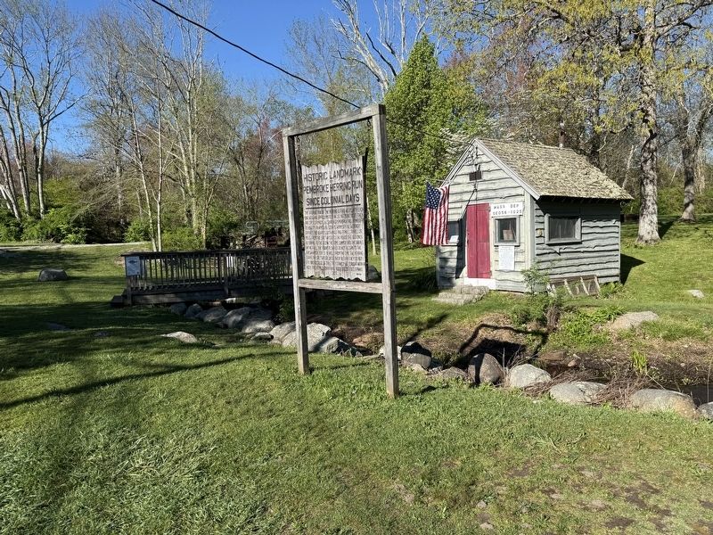
The average run of the herring is five weeks with each one weighing approximately 3/4 pounds. In Connecticut they are called Kyacks, in Canada Gaspereaux, and in Massachusetts Alewives. As soon as warm spring weather arrives, the alewives, both male . . . — — Map (db m299846) HM
In Memoriam
First Pound erected by the Town of Pembroke. 1712 of wood; area 20 x 20; cost 40 s. Second Pound erected on or near former site, 1824 of stone; area 20 x 20; cost $55.00 Repaired by the Town, 1909 — — Map (db m218836) HM
To Honor and Perpetuate the Memory of
John Eddy and Samuel Eddy
Arrived at Plymouth on the “Handmaid” Oct. 29, 1630
Sons of Rev. William Eddye, B.A., M, A. Cambridge, England
Vicar of St. Dunstan church, Cranbrook, Kent 1591-1616
John . . . — — Map (db m75829) HM
Alexander Scammell
1747 -- 1781
Teacher Soldier Patriot
He taught the public school on this site
Colonel and Adjutant General in the
Continental Army
mortally wounded at Yorktown
This memorial dedicated by the
General . . . — — Map (db m73209) HM WM
America’s first street and site of the home of William Brewster, the Pilgrims’ spiritual leader. Formerly First Street, its name was changed to Leyden Street in honour of the city in the Netherlands that offered refuge to the Pilgrims. — — Map (db m107444) HM
Plymouth, “America’s Hometown” is the site of the first permanent settlement of English Colonists in New England. Climb aboard Mayflower II, a recreation of the ship that sailed the Pilgrims to the new world . . . and learn . . . — — Map (db m107545) HM
The Pilgrams landed in Plymouth, America's Hometown, in December 1620. Covering 102 square miles, it is the largest town in the Commonwealth of Massachusetts. Plymouth's shoreline stretches 37 miles along Cape Cod Bay and with its boundaries lay 365 . . . — — Map (db m108370) HM
Brewster Gardens Brewster Gardens was created in 1921-1923 through the imagination, dedication and persistence of several Plymount women as part of the Plymouth's Tercentenary celebration of the landing of the pilgrims. It encompasses the . . . — — Map (db m151301) HM
Built in 1832 by Capt. James Bartlett Master of the Barque HANNAH in the West Indies Trade. This is the third house on this site which was originally the land of Samuel Fuller of the Mayflower. Captain Bartlett’s daughter married Isaac Brewster and . . . — — Map (db m107438) HM
You are standing at the corner of Leyden Street and Water Street. Leyden Street is the first street laid out in Plymouth and the location of the first Pilgrim homes. From this location one can see Cole's Hill, the Waterfront and Leyden Street . . . — — Map (db m75826) HM
Has been designated a Registered National Historic Landmark Under the provisions of the Historic Sites Act of August 21, 1935 this site possesses exceptional value in commemorating and illustrating the history of the United States. U.S. . . . — — Map (db m107424) HM
Dedicated to All Who Served
Honorably During the Conflicts of
Korea 1950 - 1955
Vietnam 1961 - 1975
Especially to Those Who Made
The Supreme Sacrifice
Frederick T. Garside · Robert B. Hedge · Wayne P. Moore · Paul A. Rezendes . . . — — Map (db m295386) WM
This lot bounded by Middle or King St. and LeBaron Alley was once owned by Dr. Samuel Fuller of the Mayflower and was given by his wife and son to the First Church for the use of the minister. — — Map (db m107437) HM
They believed in religious freedom in honor of Edward Doty Passenger on the Mayflower Erected by Descendants of Eliza Doty Gravath A pioneer to Utah in 1850 — — Map (db m107526) HM
In memoriam Elder William Brewster Patriarch of the Pilgrims and their ruling elder 1609-1644 Outstanding leader of Pilgrim movement, the founding of Plimouth Plantation and the establishment of civil and religious liberty in the New World. B. at . . . — — Map (db m107522) HM
This monument marks the first burying ground in Plymouth of the passengers of the MayflowerHere, under cover of darkness, the fast dwindling company laid their dead, leveling the earth above them lest the Indians should learn how many were the . . . — — Map (db m107416) HM
Site of the First Fort Built in 1621 Lower part used for church Also site of the fort built in 1675 which was 100 ft sq. Sides 10½ ft high — — Map (db m107456) HM
This tablet is erected by the Commonwealth of Massachusetts to mark the site of the First House Built by the Pilgrims. In that house on the 27th of February 1621 new style the Right of Popular Suffrage was exercised and Miles Standish was chosen . . . — — Map (db m107431) HM
This tablet is erected by the Pilgrim Society of Plymouth to mark the site of the site of the first meeting house built in 1637 — — Map (db m295394) HM
In 1776 an earthwork fort was erected at the gurnet for the protection of Plymouth Harbor. It mounted six cannons and was manned by militiamen from Plymouth, Kingston, Duxbury and nearby towns. The first lighthouse, built in 1768, stood alongside . . . — — Map (db m107428) HM
This Original House was built in 1745 by Isaac Doten who was the Constable for the town of Plymouth, which at that time was a British Colony under the reign of George II of England. — — Map (db m107434) HM
This table is erected by the Pilgrim Society of Plymouth to mark the site of the house of William Bradford Governor of the Plymouth Colony — — Map (db m295393) HM
Jackson - Russell - Whitfield
House Built 1782
Has Been Placed on the
National Register
of Historic Places
by the United States
Department of the Interior
Listed June 2, 1982 — — Map (db m295305) HM
Leyden Street, originally known to the first settlers as First Street, Great Street or Broad Street, is where the Pilgrims began building their houses in the winter of 1620-21, and it has been the heart of the town ever since. Extending from the . . . — — Map (db m75830) HM
H I William Bradford of Austerfield Yorkshire England. Was the son of William and Alice Bradford. He was Governor of Plymouth Colony from 1621 to 1633 1635 1637 1639 to 1643 1645 to 1657 < Rear of obelisk : > Under this stone rest . . . — — Map (db m107510) HM
After the Pilgrims’ arrival, Native Americans in New England grew increasingly frustrated with the English settlers’ abuse and treachery. Metacomet (King Philip), a son of the Wampanoag sachem known as the Massasoit (Ousamequin), called upon all . . . — — Map (db m299590) HM
Here lies buried ye body of Mr. Thomas Clarke Aged 98. Departed this life March 24, 1697. Thomas Clarke was Mate of the Mayflower according to tradition in the Plymouth and connecting Colonies. History gives his arrival in Plymouth from England in . . . — — Map (db m107462) HM
Since 1970, Native Americans have gathered at noon on Cole's Hill in Plymouth to commemorate a National Day of Mourning on the U.S. Thanksgiving holiday.
Many Native Americans do not celebrate the arrival of the Pilgrims and other European . . . — — Map (db m108369) HM
This building, on the north easterly corner of Main and Leyden Streets, occupies the lot once owned by Stephen Hopkins of the Mayflower — — Map (db m295803) HM
To those intrepid English women whose courage fortitude and devotion brought a new nation into being, this statue of the Pilgrim Maiden is dedicated. Presented to the Town of Plymouth by the National Society New England Women September IV . . . — — Map (db m107423) HM
Pilgrim Memorial State Park-Plymouth Rock is a symbol for the potential the Pilgrims saw in America upon their arrival here in December of 1620. Seen as solid, steadfast and everlasting, the large Dedham granite boulder is a suitable icon for the . . . — — Map (db m62450) HM
You are standing at the corner of Leyden Street and Water Street. Leyden Street is the first street laid out in Plymouth and the location of the first Pilgrim homes. From this location one can see Cole’s Hill, the Waterfront and Leyden Street . . . — — Map (db m75819) HM
The Massachusetts Society of the Sons of the American Revolution came to Plymouth on October 12, 1920 to dedicate this replica of the old Powder House. The original structure had been erected in Plymouth in 1779 and removed about 1880. The Society . . . — — Map (db m107466) HM
In 1941 ten thousand Jews from Bobruysk (Belarus) were taken from the overcrowded ghetto in which they had been forced to live and were murdered by the Nazis in the woods of Kaminka. The bodies were burned in long trenches, dug by 1,000 military . . . — — Map (db m256849) HM WM
Fellow-exile with the Pilgrims in Holland, afterwards their chief agent in England. Arrived here IX November, MDCXXI, with Thomas Cushman his son; Preached IX December, his memorable sermon on “The danger of self-love and the sweetness of true . . . — — Map (db m107459) HM
Site of one of the houses built in 1621. Seven dwelling houses were built the first year in addition to the one occupied by the Governor. This lot was assigned to Peter Brown. — — Map (db m107440) HM
Brass cannon like these were named by Bradford and Winslow in the annals of Plymouth as mounted on the
First Fort, 1621, and were still in use in 1645 when the Ancient And Honorable Artillery Company Of Massachusetts under its commander Major . . . — — Map (db m73187) HM
The Church of Scrooby Leyden and the Mayflower gathered on this hillside in 1620 has ever since preserved unbroken records and maintained a continuous ministry. Its first covenant being still the basis of its fellowship. In reverent memory of its . . . — — Map (db m107446) HM
Built by Captain William Barnes in 1795 for his new bride, Sally Tribble. This house sits on the original site of “The Common House” established by the Pilgrims in 1623. Here the Pilgrims stored food and housed their families until . . . — — Map (db m107436) HM
On this site until 1749 stood
The Government House
Of the old Colony
In that year this building was erected
By the county for a court house
It was used jointly by the county
And the town until 1820
And then became the property of . . . — — Map (db m187343) HM
This tablet is inscribedin grateful memory of the Pilgrims and of their successors who at the time of the Unitarian Controversy in 1801 adhered to the belief of the Fathers and on the basis of the original creed and covenant perpetuated . . . — — Map (db m107454) HM
Pilgrim Memorial State Park is designed around Plymouth Rock, a large glacial boulder deposited in the harbor and smoothed by centuries of tidal wash. The rock is not only a landmark, but also a symbol of the courage and faith of the men and women . . . — — Map (db m107542) HM
William Bradford Governor and Historian of the Plymouth Colony Born in Austerfield, England – 1590 Died in Plymouth, New England – 1657 < Side of Monument : > “So they lefte ye goodly & pleasante citie, which had been . . . — — Map (db m75823) HM
September 11, 2001 God Bless America
8:47 A.M. Tower I North World Trade Center
9:02 A.M. Tower II South World Trade Center
9:41 Pentagon Arlington, VA.
10:00 A. M. Shanksville, PA. — — Map (db m229178) WM
September 11, 2001 "Now each of us has a responsibility to live with the same courage embraced by those who died in the attacks on the world trade center, the Pentagon, and the hijacked plane that crashed in Pennsylvania. We have an . . . — — Map (db m234068) WM
Granite remnant of the first canopy over
Plymouth Rock from 1867-1920
Designed by Hammett Billings
Donated by the Balboni Brothers and Family — — Map (db m220695) HM
Built 1955 1957
has been placed on the
National Register
of Historic Places
by the United States
Department of the Interior
Designed by naval architect William A. Baker, this
historic ship is a reproduction of the 17th-century . . . — — Map (db m220671) HM
"In April and May come up another kind of fish which they call herring or old wives in infinite schools, into a small river running under town, and so into a great pond or lake of a mile broad, where they cast their spawn, the water of the said . . . — — Map (db m220694) HM
Mayflower II is a full-scale reproduction of the original Mayflower that the Pilgrims sailed on from England to America in 1620. Built by hand in England, and listed on the U.S. National Register of Historic Places, Mayflower II is an iconic . . . — — Map (db m220692) HM
In Memory of the Men Who Made
the Ultimate Sacrifice
Spanish American War, World War I, World War II
Spanish-American War
Peter A. Bowler • John A. Cullinan • Patrick H. Mahoney
Joseph B. Murphy • Joseph E. . . . — — Map (db m118204) WM
If you had
looked out to sea
from this point on
June 1, 1813
you would have seen the
ship-to-ship battle between
USS Chesapeake and HMS Shannon
where Captain James Lawrence
spoke his famous last words
“Don’t Give Up The . . . — — Map (db m95609) HM WM
Home of the Scituate Historical Society on land granted to Richard Garrett prior to 1646. Zephanian Cudworth built the present house in 1797 around the original chimney. — — Map (db m47900) HM
Boundary line between Norfolk and Plymouth Counties, originally established in 1640 as the boundary between the colonies of Massachusetts Bay and New Plymouth. — — Map (db m298864) HM
Front:
“Erected on this Lott
Aug. Ye 2d & 3d dayes, 1636.
Exercised in Novemb. 10 & 11, 1636.”
Top:
To the Memory of
The First
Ministers of Scituate
Giles Saxton — Nathaniel Pitcher
John . . . — — Map (db m30616) HM
This historic tower – a gift to the town in 1902 from Thomas W. Lawson, “The Copper King” has an over all height of 153 feet and encloses a water tank, a clock room and a bell room complete with tuned bells upon which melodies are played on . . . — — Map (db m218926) HM
A unique historical site in that its construction spans nearly three centuries. Five generations of the Mann family lived in this house. They were direct descendants of Richard Mann who settled in Scituate in 1636. — — Map (db m43638) HM
Burial place of many of the town’s original settlers who came from Kent County, England, in 1628. This is also the site of the first church in Scituate, built in 1634. — — Map (db m30615) HM
During the year 1810 the U. S. Congress voted [$]4000 to build a lighthouse at Scituate harbor. During the War of 1812 Abigail and Rebecca Bates, young daughters of the lighthouse keeper, prevented a British naval force from sacking the town . . . — — Map (db m23484) HM
In 1640 Isaac Stedman dammed up First Herring Brook and beside the pond thus formed, constructed the first water driven grist mill in the old colony. The mill owned and operated by the Stockbridge and Clapp families until 1922 was made famous in . . . — — Map (db m24546) HM
From which the town derived its name. The Indian word first written Satuit or Seteat, meaning cold brook, was changed in 1640 to Scituate. — — Map (db m42628) HM
The Stockbridge mansion, built before 1660, stood on this site. It was a garrison house in King Philip’s War for protection of the mills, and was successfully defended. The pond and mill were made famous by Woodworth’s poem "The Old Oaken Bucket." — — Map (db m48800) HM
This monumental 700-pound bell was cast in 1864 by Henry N. Hooper and Company – a firm begun by Paul Revere. This bell once rested on the Graves Ledge Bell Boat and served to warn unsuspecting mariners of certain danger. The Graves Ledge Bell Boat . . . — — Map (db m207215) HM
The Italian freighter Etrusco, a 7000 ton liberty ship, grounded here March 16, 1956, in a northeast blizzard. All hands safe. Refloated November 22, 1956.
Placed by the Cedar Point Association on the 30th anniversary of grounding and the . . . — — Map (db m23486) HM
Homestead and well made famous by Samuel Woodworth in his poem “The Old Oaken Bucket.” Homestead erected by John Northey in 1675; poet born in Scituate January 13, 1785. — — Map (db m48801) HM
The Wharf Area
Industrial Epicenter for the Harbor and Town
The period of time between the mid 1600's through the mid 1800's defined Scituate as one of the most prosperous harbors between Boston and New Bedford. As maritime based industries grew . . . — — Map (db m304874) HM
The first plantations at "Satuit" were laid out by the Men of Kent before 1628 on this cliff, which was then much more extensive. — — Map (db m48038) HM
A portion of the house built by John Williams in 1634 is incorporated in the present house. It was a "garrison" or place of refuge and defense during King Philip's War. — — Map (db m48804) HM
Mordecai Lincoln Homestead
A walk through nature and a journey through time
Over three hundred years ago, Mordecai Lincoln,
the great-great-great-grandfather of U.S. President
Abraham Lincoln. purchased property
on Bound Brook, overlooking . . . — — Map (db m307750) HM
The rank and financial status of Ft. Warren residents determined the quality of meal they ate. Rations for Union soldiers consisted of fresh beef with potatoes three times a week, salt beef, pork or ham three times a week, and baked beans on Sunday. . . . — — Map (db m108118) HM
Harbor mines and cables fill the pier during the Second World War. Built in 1906, the mine-storage building (background) now houses the visitor’s center. (Inscription below the title) Countering the threat of the submarine, the U.S. military mined . . . — — Map (db m62557) HM
During the War Between the States, 1861-1865 more than a thousand Confederates were imprisoned here of whom thirteen died.
D.B. Cartwright CO H 32 N.C.
James J. Cooper CO. F 17 N.C.
Col. T.J. Davidson 25 Miss
A. Diggs citizen, VA
Aquila . . . — — Map (db m59205) HM
From this vantage point it is possible to see the principal elements of Ft. Warren’s defense system. These are based on the 17th century, military theories developed by Louis XIV’s chief engineer, Sebastien de Vauban, and were modified to meet 19th . . . — — Map (db m62581) HM
Both Union Soldiers training at Ft. Warren and Confederate prisoners of war were quartered along this side of the fort, often in adjoining rooms. his area also contained a schoolroom, 1900-volume library, and a chapel which was used almost daily by . . . — — Map (db m59282) HM
Despite the prison's island location, a few Civil War prisoners tried to escape-in the end, always unsuccessfully. Among them was Pvt. Charles Sawyer, a Union deserter who widened this narrow musketry "loophole" (opening to the right), supposedly by . . . — — Map (db m59283) HM
Has been designated a registered National Historic Landmark Under the provisions of the historic sites act of August 21, 1935 this site possesses exceptional value in commemorating or illustrating the history of the United States — — Map (db m108117) HM
From the beginning, Fort Warren’s heart was the six-acre parade ground. When the Civil War broke out soon after the fort was completed, the area was still covered in construction debris. Newly enlisted Massachusetts regiments cleaned it up as they . . . — — Map (db m108116) HM
Among the notable political prisoners confined in these rooms were James Murray Mason and John Slidell, two Confederate envoys to Great Britain. Their arrest on board the British steamer Trent provoked an international incident and nearly brought . . . — — Map (db m108115) HM
There were nine magazines within the fort's bastions and fronts during the Civil War, all of the located at the parade ground level. They were lined with wood to prevent a soldier's gun or belt buckle from striking against the granite walls and . . . — — Map (db m168261) HM
“An army marches on its stomach,” Napoleon famously said---a statement that held true at Fort Warren. Soon after its construction, two unfinished casemates (bunkers) in Bastion C were equipped with tables and benches and pressed into . . . — — Map (db m108113) HM
199 entries matched your criteria. Entries 101 through 199 are listed above. ⊲ Previous 100