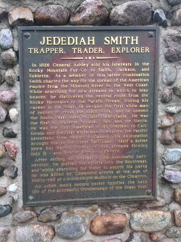
When Jedediah was 23 years of age he went to St. Louis and enlisted with General William H. Ashley as an employee of the Rocky Mountain Fur co. In 1823 he was with Ashley and a party of 90 trappers, traders, and boatmen when they were attacked by . . . — — Map (db m179958) HM
In the summer of 1823, two of the first battles between Indians and Whites in South Dakota took place as a result of the desire for revenge. The conflicts began when the Arikara (Sahnish), living along the Missouri River at the time, blamed . . . — — Map (db m113317) HM
Welcome to the Standing Rock National Native American Scenic Byway, an 86 mile route which follows a stretch of highway that climbs up and down the stunning Missouri River breaks and runs past buffalo herds and eagle's nests. History comes . . . — — Map (db m113315) HM
Sakakawea won her place in history as the indomitable guide of Lewis and Clark on their trip to the Pacific in 1805. She was a member of the Shoshoni tribe dwelling near the Big Horn mountains in Montana. In one of the frequent tribal conflicts . . . — — Map (db m190173) HM
Sitting Bull was born on the Grand River a few miles west of Mobridge. His tragic end came at the very place he was born. He was shot when being arrested because of his alleged involvement with the Ghost Dance craze.
Sitting Bull was . . . — — Map (db m127088) HM
"This village is built upon an open prairie, and the gracefully undulating hills the rise in the distance behind it are everywhere covered with a verdant green turf, without a tree or a bush anywhere to be seen. This view was taken from the . . . — — Map (db m113316) HM
Although extensive trade networks were always part of the economies of the indigenous Tribes in North America, the trade in furs between Native peoples and European traders emerged as the major tribal industry on the Missouri River from the . . . — — Map (db m113318) HM
This memorial is erected by authority of the Congress of the United States of America Act of April 29, 1930.
In honor of deceased chiefs of the Cheyenne River Sioux Tribe of Indians and the valiant men of that tribe who made the supreme . . . — — Map (db m246484) WM
The railroad came to the Cheyenne River Sioux Reservation in 1910. This small depot station is one of the last remaining of many such buildings on this old line that witnessed the flow of goods and people to and from many such whistle stop . . . — — Map (db m246483) HM
Leader of the Fool Soldiers, Martin Charger established a permanent camp here midway between the Cheyenne and Moreau rivers on the west bank of the Missouri River. In October 1804 the Lewis and Clark Expedition encamped just to the west of this . . . — — Map (db m235419) HM
The Naca' Monument is a memorial to the families of the Cheyenne River Sioux Tribe that once lived along the river. It is placed along the Missouri River above the site of the town of Old Agency, which was located on the west shore of the river just . . . — — Map (db m246493) HM
This monument is erected by the Cheyenne River Sioux Tribe to recognize and honor our (Naca) Leaders who have made an impact on the lives of our people, assured the safety of our traditions and helped to preserve our native language. It is through . . . — — Map (db m246497) HM WM
St. Basil's Church was built in 1917 by the children and friends of Mountainman Basil Claymore. Constructed in the French tradition of a family chapel it served as a Catholic church. Father John Vogel was the first priest to officiate at this . . . — — Map (db m304925) HM
This area and culture was built upon the characteristics of determination and grit, honesty, integrity, and a high level of
respect for family, neighbors, and friends. This description couldn't be any better exemplified than through the life of Bud . . . — — Map (db m279951) HM
Where Highways US 212 and SD 73 meet, at the end of the Cheyenne Branch of the Milwaukee Road, we live, a half mile above sea level of the Fox Ridge Divide, our souls nourished by the picture sunsets.
Our Grass is unsurpassed anywhere, . . . — — Map (db m185219) HM
Small Town
By Badger Clark
The circling cones of bison hide
that made the village of the Sioux
Rose near as high, spread near as wide,
O little Western town, as you.
But small-town skylines all are great
And . . . — — Map (db m185220) HM
This scrap iron sculpture was created to commemorate Sue, the largest, most complete and best preserved T-Rex found to date! Ninety percent of her original bones were found. Only a foot, an arm and a few ribs and vertebrae are missing. Sue was . . . — — Map (db m153969) HM
Castle
This magnificent structure has been constructed out of prehistoric logs, some of which weigh more than 10,000 pounds apiece. The entire castle is composed of more than 300 tons of petrified rock (think 8 full semi-trucks, or 200 . . . — — Map (db m231224) HM
Ole S. Quammen, the mastermind behind the Petrified Wood Park, was born in 1871, his family immigrated to America in 1872 and homesteaded in MN. When Quammen was 23 he became a Watkins Medical Co. distributor which eventually led him to Voltaire, ND . . . — — Map (db m231140) HM
father of Mrs. Harry C. Olson,
the creator and donor of this,
the world's largest
Petrified Wood Park of its kind.
Mr. Quammen's picture is displayed in the museum. — — Map (db m113240) HM
Petrified wood is actually a fossil. and these are estimated to be 20-30
million years old.
The petrification process can take very little time under the right circumstances but the longer the process is given, the harder the rocks will . . . — — Map (db m231496) HM
Several large red/pink stones can be located throughout the park that have an interesting history. In 1889 North Dakota and South Dakota simultaneously were admitted to the Union and became the 39th and 40th state.
In 1890 US Congress passed a . . . — — Map (db m231228) HM
Constructed in 1933, the Petrified Wood Park Museum is a truly impressive structure. The walls of the building are constructed from petrified logs and the flooring of the original building is made of petrified grass and reeds. The base of the walls . . . — — Map (db m231226) HM
At this point the Bismarck-Deadwood Stage Trail passed in a line extending about 240 miles from northeast to southwest. In 1877, the Dakota Territorial Legislature commissioned the survey of the trail, which transported passengers and freight . . . — — Map (db m190172) HM
At 10:00 PM, October 20, at 1944, a four-engined B-24 bomber crashed with a crew of 10 men on the Hubler farm, 6 miles north east of Meadow, SD. Four crewman were killed and one injured. Those who died were Lt. Milan J. Mikulec, 23 bombardier, . . . — — Map (db m205041) HM WM
This altar to courage was erected August 1, 1923 by the Neihart Club in honor of Hugh Glass who, wounded and deserted, here began to crawl to Fort Kiowa in the fall of 1823. — — Map (db m152993) HM
Today, approximately 325,000 bison roam North America. Bison, also called buffalo, is the
largest native land mammal in North
America. They once roamed the Great
Plains in large numbers with estimates
ranging from 70 to 150 million. . . . — — Map (db m171940) HM
Be prepared for change
Thunderstorms, blizzards, and inclement weather can strike quickly and with little warning on the Great Plains. Thunderstorms & Wind uring the summer, the sun
heats the ground and causes
powerful convection . . . — — Map (db m174698) HM
Across the reservoir, situated on an overlooking bluff, stands a monument to Hugh Glass, fabled pirate turned fur trader and frontiersman. In August of 1823, while on a fur trapping endeavor with the Ashley Fur Company, Glass was attacked by a . . . — — Map (db m152992) HM
Hugh Glass, a member of the Ashley Fur Party under Major Henry, going up the Grand River in August 1823, a habitual "loner", while hunting, was attacked by a grizzly bear near the Forks of Grand River. Horribly mauled he could not be moved, a . . . — — Map (db m178664) HM
The Development of a Land Survey System
Early methods for allocating unsettled land often led to overlapping claims and border disputes. On May 20, 1875, Congress passed the Land Ordinance of 1785, implementing a standardized system of land . . . — — Map (db m152943)
The little town of Seim slipped below the water and into memory when the Shadehill Dam was built. The town was founded in 1894, named after one of the first pioneer settlers in the area. During its prime in the early 1900s, the town had banks, . . . — — Map (db m152990) HM
Beginning in 1949, the Bureau of Reclamation began construction on a dam on the forks of the Grand River. Built for the purpose of crop irrigation and flood control, Shadehill Reservoir is a part of the larger Pick– Sloan Missouri Basin . . . — — Map (db m152991) HM
The Grand River National Grassland in encompasses 155,000 acres in northwestern South Dakota. The Grand River Ranger District, in Lemmon, South Dakota administers the Grand River and Cedar River National Grassland. The Cedar River National Grassland . . . — — Map (db m154053) HM
In 1882, a dramatic rescue of white captives held by a band of hostile Santee
Sioux, took place near this spot. A group of eleven young Teton Sioux boys left
Ft. Pierre on a cold November day determined to overtake and meet with the Santees to . . . — — Map (db m180985) HM
In 1906, one hundred years after the Lewis and Clark Expedition passed through this area, Milwaukee Railroad crews labored to build a bridge across the Missouri River. They carefully worked, balancing themselves on high metal beams as the sound . . . — — Map (db m112089) HM
One of the most notable women in American History may well be Sakakawea. A Shoshoni Indian girl named Sakakawea, acted as an interpreter while traveling with the Corps of Discovery on their way to and from the Pacific Ocean. As the Corps headed . . . — — Map (db m112141) HM
Near present-day Mobridge, South Dakota, Captain William Clark wrote in his journal that he saw "White bear" tracks. These tracks, which are "…3 times as large as a mans track…" were actually from a grizzly bear.
During the entire . . . — — Map (db m112150) HM
During the Indian uprisings in Minnesota in 1862, a band of Santee Sioux Indians took several white women and children captive. They brought them to an area near here, opposite the mouth of the Grand River in present-day Walworth County, South . . . — — Map (db m112137) HM
In 1806, not long after Lewis and Clark passed through this area, a young man was born in a Village near the Grand River (near present-day Mobridge, South Dakota). This young man, known as Sitting Bull, was a famous Sioux medicine man and . . . — — Map (db m112116) HM
Captain William Clark enlisted his slave, York, as one of the members of the Corps of Discovery. York grew up in Virginia with Clark and traveled with the party during the entire journey to the Pacific Ocean and back to St. Louis, Missouri.
. . . — — Map (db m112155) HM
Here on Sept. 9, 1807 Ensign Nathaniel Pryor attempting of return Big White, Mandan Chief, to his people was stopped and had 19 Casualties in the First battle with Indians in South Dakota. — — Map (db m112092) HM
A bit of history lies under the water behind Oahe Dam. Before the dam was built many islands and sandbars were commonly found along the Missouri River. When the Corps of Discovery traveled along this river on the way to the Pacific Ocean they . . . — — Map (db m112088) HM
Leadership in the American Indian culture is much different than the Euro-American views. Unlike the Euro-American concept of a formal majority vote to select a leader, American Indians were made leaders by those who simply chose to follow them. . . . — — Map (db m112118) HM
Here on October 9-12, 1804 Lewis & Clark counseled and sojourned with the Aricara Indians and were again here on their return from the Pacific on August 21-22, 1806. — — Map (db m112106) HM
By the 1500s, the descendants of the Skiri Pawnee People, the Arikara (or Ree) Indians, inhabited this area. Twelve village bands lived along the Missouri River in present-day South Dakota. Three of the villages were near the mouth of the . . . — — Map (db m112108) HM
In 1804-06, Captains Meriwether Lewis and William Clark led about 40 soldiers and boatmen on an epic journey. President Thomas Jefferson commissioned this "Corps of Discovery' to find a route to the Pacific Ocean through the newly acquired . . . — — Map (db m112122) HM
Lewis and Clark
The Lewis a nd Clark Expedition, officially the Corps of Discovery, was in what is now South Dakota from August 21 to October 14, 1804 and from August 21 to September 4, 1806.
While here they would make numerous . . . — — Map (db m112145) HM
1924
Mobridge Bridge
Dedicated to
The People of South Dakota
November 12, 1924
Built under the Direction of
The State Highway Commission
Governor W.H. McMaster - Chairman
Made possible by loans to the State of South Dakota . . . — — Map (db m112105) HM
Here on Sept. 12, 1809 Pierre Choteau Managed to Pass the Aricara with Big White.
Here in June - July 1811 Manuel Lisa & Astorians joined forced, Pacified and traded with the Aricara — — Map (db m112107) HM
Dedicated to the early settlers of the Mobridge area, Revheim Park is named for Mons J. Revheim who established a homestead on this site in 1881. During the Great Dakota Boom of 1878-1887, thousands of landseekers headed for western Dakota Territory . . . — — Map (db m154041) HM
This wide, low moving, Missouri River of today is quite different from when the Corps of Discovery navigated in then torrent waters in 1804. Lewis and Clark fought against the strong current, using ropes to pull the boat upstream. By the time . . . — — Map (db m112114) HM