By J. J. Prats, September 29, 2006
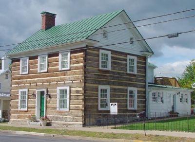
The Rupp House
SHOWN IN SOURCE-SPECIFIED ORDER
| On Congress Street (U.S. 11) at Breckinridge Lane, on the right when traveling south on Congress Street. |
| On Main Street (U.S. 11) at Nelson Street (Local Route 1314), on the right when traveling north on Main Street. |
| On Main Street (U.S. 11) south of Nelson Street (Local Route 1314), on the left when traveling north. |
| On East King Street (Virginia Route 55) 0.1 miles east of Acton Place, on the right when traveling east. |
| On Main Street (U.S. 11) south of Nelson Street (Local Route 1314). |
| On East King Street (Virginia Route 44), on the left when traveling west. |
| On Valley Pike (U.S. 11) 0.4 miles north of Quarry Road, in the median. |
| Near Main Street (U.S. 11) near Daniel Grey Street. |
| On N. Massanutten Street (Route 11) 0.1 miles south of Thompson Street, on the right when traveling south. |
| On Old Valley Pike (U.S. 11) south of Caverns Road at Exit 269 (Interstate 81), on the right when traveling south. |
| On Old Valley Pike (U.S. 11) south of Caverns Road at Exit 269 (Interstate 81), on the right when traveling south. |
| On West Washington Street at North Fort Street, on the right when traveling west on West Washington Street. |
| On East Washington Street at North Holiday Street, on the right when traveling east on East Washington Street. |
| On Lee Highway (U.S. 211) 0.1 miles west of Crisman Hollow Road, on the right when traveling east. |
| On Old Valley Pike (U.S. 11) near Caverns Road at Exit 269 (Interstate 81), on the right when traveling south. |
| On George Collin Parkway (Virginia Route 305) 0.5 miles north of West Old Cross Road (U.S. 211), on the left when traveling north. |
| On Old Valley Turnpike (U.S. 11) north of New Market. |
| On George Collin Parkway aka Miller Lane (Virginia Route 305) near Interstate 81, exit 264 west (U.S. 211), in the median. |
| On Old Valley Turnpike (U.S. 11) north of New Market, on the right when traveling south. |
| On Old Valley Pike (U.S. 11) north of New Market, on the right when traveling south. |
| On Congress Street (U.S. 11) at Breckinridge Lane, on the right when traveling south on Congress Street. |
| On Old Valley Pike (U.S. 11) south of Caverns Road at Exit 269 (Interstate 81), on the right when traveling south. |
| On Old Valley Pike (U.S. 11) south of Smith Creek Road (Local Route 620), on the right when traveling south. |
| Near George Collin Parkway (Virginia Route 305) at West Old Cross Road (U.S. 211). |
| Near George Collin Parkway (County Route 305), on the right when traveling south. |
| Near George Collin Parkway (County Route 305), on the right when traveling south. |
| Near George Collin Parkway (County Route 305), on the right when traveling south. |
| Near George Collin Parkway (County Route 305), on the right when traveling south. |
| On Old Valley Pike (U.S. 11), on the right when traveling south. |
| On Old Valley Pike (U.S. 11), on the right when traveling south. |
| On Old Valley Pike (U.S. 11), on the right when traveling south. |
| On Old Valley Pike (U.S. 11) at Millner Road (County Route 644), on the right when traveling north on Old Valley Pike. |
| On Battlefield Road (County Route 601) at Tripplet Road (County Route 821), on the right when traveling west on Battlefield Road. |
| Near Battlefield Road (Virginia Route 601) 0.3 miles Tumbling Run Lane, on the right when traveling east. |
| Near Battlefield Road (County Route 601), on the right when traveling east. |
| On Old Valley Pike (U.S. 11) at Battlefield Road (County Route 601), on the right when traveling south on Old Valley Pike. |
| On Old Valley Turnpike (U.S. 11) north of Moreland Gap Road, on the left when traveling south. |
| On Quicksburg Road (County Route 767) 0.2 miles east of Senedo Road/Middle Road and Quicksburg Road, on the left when traveling east. |
| On West Court Street at School Street, on the right when traveling east on West Court Street. Reported missing. |
| On Valley Pike (U.S. 11), on the right when traveling south. |
| On Valley Pike (U.S. 11) 0.1 miles south of Signal Knob Drive, on the right when traveling south. Reported permanently removed. |
| On Old Valley Pike (U.S. 11) at Signal Knob Drive, on the right when traveling south on Old Valley Pike. |
| Near Old Valley Pike (U.S. 11), on the right when traveling south. |
| Near Valley Pike (U.S. 11) 0.1 miles west of Signal Knob Drive, on the right when traveling south. |
| On Valley Pike (U.S. 11) 0.4 miles north of Quarry Road, in the median. |
| On N. Massanutten Street (U.S. 11) at Cold Spring Road, on the right when traveling south on N. Massanutten Street. |
| On Valley Pike (U.S. 11), on the right when traveling north. |
| On South Holiday Street at Ram Drive (Virginia Route 9746), on the left when traveling south on South Holiday Street. Reported damaged. |
| On Old Valley Pike (U.S. 11) south of Caverns Road at Exit 269 (Interstate 81), on the right when traveling south. Reported damaged. |
| On Old Valley Pike (U.S. 11) at Monument Lane (Virginia Route 828), on the left when traveling north on Old Valley Pike. |