On Boston Post Road (U.S. 20) at Concord Road, on the right when traveling west on Boston Post Road.
To the left is the site of Hop Brook Mill, erected in 1659 by virtue of a town grant to Thomas and Peter Noyes, "to build and maintain a mill to grind the corn of the settlers." It is now the property of Henry Ford. — — Map (db m48812) HM
On Boston Post Road (U.S. 20) 0.2 miles east of Old County Road, on the left when traveling west.
Settled 1638 by a company of Puritans who arrived in the ship "Confidence" and were attracted by the meadows on the Musketaquid River. Named after Sudbury in Suffolk. — — Map (db m48028) HM
On Boston Post Road (U.S. 20) at Concord Road, on the right when traveling west on Boston Post Road.
One-quarter mile north took place the Sudbury Fight with King Philip's Indians on April 21, 1676. Captain Samuel Wadsworth fell with twenty-eight of his men; their monument stands in the burying ground. — — Map (db m48811) HM
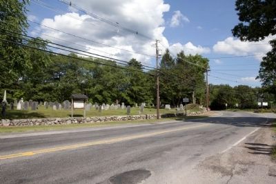
On Boston Post Road (U.S. 20) just west of Goodmans Hill Road, on the left when traveling west.
Portion of the Goodenow Garrison
House in which the settlers took
refuge from King Philip's Indians
during the battle of April 18-21,
1676. — — Map (db m48813) HM
On Middlesex Road (Massachusetts Route 3A) at Tyng Road, on the right when traveling south on Middlesex Road.
This mansion was built in 1675 by Colonel Jonathan Tyng for whom this town was named. It was the northerly outpost to the garrison house which stood a quarter-mile down stream opposite Wicassee Falls and Island where the Pawtucket Indians were . . . — — Map (db m48835) HM
On Main Street (Massachusetts Route 20), on the right when traveling east.
Settled by Puritans in 1630 under the leadership of Sir Richard Saltonstall and the Rev. George Phillips who stood firmly for religious toleration and the right of the people to a representative government. — — Map (db m48029) HM
On Galen Street (Massachusetts Route 16) at Main Street (Massachusetts Route 20), on the right when traveling south on Galen Street.
Settled by Puritans in 1630 under the leadership of Sir Richard Saltonstall and the Rev. George Phillips who stood firmly for religious toleration and the right of the people to a representative government. — — Map (db m48030) HM
On Washington Street at Forest Street, on the right when traveling north on Washington Street.
In 1638 this tract of about one hundred and twenty acres was granted by the town of Charlestown to its Teaching Elder John Harvard. He died the same year, aged thirty-one, leaving half his property to the College which was then named after him. — — Map (db m48833) HM
On Main Street at Converse Place, on the left when traveling south on Main Street.
Built in 1640 by Edward Converse, who led the party sent out by Charlestown to explore "Waterfield." Selectman twenty-four years, deacon nineteen years, arrested in 1662 for speaking disrespectfully of the King's letter. — — Map (db m48831) HM
On Main Street at Everell Road, in the median on Main Street.
Farm of about three hundred acres granted to the Reverend Zachariah Symmes, first minister of Charlestown, in 1634. This portion of the farm is still owned by his descendants. — — Map (db m48830) HM
Settled by men from Charlestown under Captain Edward Johnson. Named in 1642 after Woburn, Bedfordshire. Here was born and grew up together Colonel Loammi Baldwin, the Engineer, and Benjamin Thompson (Count Rumford), Philanthropist and Scientist. — — Map (db m48764) HM
The north line of Ponkapoag Plantation second of the Apostle Eliot's Praying Indian towns, set apart by the Dorchester Proprietors in 1657. — — Map (db m48803) HM
On Eastern Avenue at East Street, on the right when traveling east on Eastern Avenue.
Oldest house in Dedham, a part of it built about 1636. Homestead of Jonathan Fairbanks, who, with his sons John, George, and Jonathan, Junior, signed the Dedham Covenant September 10, 1636. Ancestral home of the late Vice- President Fairbanks. — — Map (db m48808) HM
On Main Street (Massachusetts Route 109) at Pound Street, on the right when traveling west on Main Street.
The original house, built in 1651, was burned when King Philip's Indians burnt the town of Medfield in 1676. Seth Clark, the owner, received indemnity from the colonial government and in 1680 rebuilt the present Peak house, so called because of its . . . — — Map (db m48797) HM
On Adams Street at Churchills Lane, on the right when traveling east on Adams Street.
Churchill's Lane. When the Indians sold their land near the mouth of the Neponset River they removed to the territory south of the Blue Hills, which they called Ponkapoag, sweet water. — — Map (db m48814) HM
On Quincy Shore Drive, 0.1 miles east of Squantum Street, on the right when traveling west.
Moswetuset Hummock was the seat of Chickatawbut, Sagamore of the Massachusetts Indians; adjoining were their planting grounds. "Massachusetts" means "at the Great (Blue) Hills." With Chickatawbut Governor Winthrop made a treaty which was never . . . — — Map (db m48818) HM
On Beale Street, 0.1 miles north of Arlington Street, on the left when traveling north.
In William Hutchinson's house near this spot his wife Anne tarried on her way to Rhode Island, exiled from Massachusetts by the General Court in April, 1638. — — Map (db m48816) HM
Erected in 1681, it is the oldest church structure in the United States to have been used continuously for public worship. Samuel Lincoln, original American ancestor of Abraham Lincoln, worshipped here regularly. — — Map (db m48810) HM
On North Street at Lincoln Street, on the right when traveling east on North Street.
Samuel Lincoln, ancestor of President Abraham Lincoln, and one of the eight early settlers of Hingham bearing that name, purchased this land in 1649. Seven generations of Lincoln descendants lived here. — — Map (db m42633) HM
On Ocean Street (Massachusetts Route 139) at Moraine Road (Massachusetts Route 3A), on the left when traveling west on Ocean Street.
The Old Marshfield Training Field and Meetinghouse of the First Parish where Daniel Webster attended church.
Home of Daniel Webster. Home of Governor Edward Winslow. Historic Winslow House is open to visitors in summer. — — Map (db m48763) HM
On East Main Street (Massachusetts Route 105) 0.1 miles Montello Street, on the right when traveling east.
Site of the ford or wading place where the Indian trail from Plymouth to "Middleberry" (Middleborough) crossed the Nemasket River. When the town was established, 1669, its southern boundary was described as extending "Six mile from the wadeing . . . — — Map (db m48788) HM
On Country Way, 0.1 miles south of Mordecal Lincoln Road, on the left when traveling north.
Boundary line between Norfolk and Plymouth Counties, originally established in 1640 as the boundary between the colonies of Massachusetts Bay and New Plymouth. — — Map (db m49623) HM
On Front Street, on the right when traveling north.
From which the town derived its name. The Indian word first written Satuit or Seteat, meaning cold brook, was changed in 1640 to Scituate. — — Map (db m42628) HM
On Country Way just north of the Greenbush Rotary, on the left when traveling north.
The Stockbridge mansion, built before 1660, stood on this site. It was a garrison house in King Philip’s War for protection of the mills, and was successfully defended. The pond and mill were made famous by Woodworth’s poem "The Old Oaken Bucket." — — Map (db m48800) HM
On Old Oaken Bucket Road, on the left when traveling west.
Homestead and well made famous by Samuel Woodworth in his poem “The Old Oaken Bucket.” Homestead erected by John Northey in 1675; poet born in Scituate January 13, 1785. — — Map (db m48801) HM
On Collier Road (a one-way street) at Cliff Avenue, on the left when traveling south on Collier Road (a one-way street).
The first plantations at "Satuit" were laid out by the Men of Kent before 1628 on this cliff, which was then much more extensive. — — Map (db m48038) HM
On Barker Road, 0.1 miles north of Brookline Road, on the right when traveling north.
A portion of the house built by John Williams in 1634 is incorporated in the present house. It was a "garrison" or place of refuge and defense during King Philip's War. — — Map (db m48804) HM
On Parker Street at Broadway, on the right when traveling west on Parker Street.
Six hundred feet from this point is the mansion built by Governor Richard Bellingham in 1659, rebuilt and enlarged by Samuel Cary in 1791. Here Washington stationed the last outpost of the left wing of the Continental Army besieging Boston. — — Map (db m48829) HM
On Shirley Street, on the right when traveling south.
In 1637 William Peirce, Captain of the ship "Lion" erected this house which was occupied from 1647 to 1703 by Deane Winthrop, younger son of Governor Winthrop. — — Map (db m48828) HM
On Shirley Street at Ingleside Avenue on Shirley Street.
Site of house erected by Governor Winthrop about 1634 and occupied for a time previous to 1647 by his son Deane who established on the nearby hill a ship signaling station by hoisting a bush to the top of a pole. — — Map (db m48825) HM
On W Main Street, on the right when traveling west.
Settled in 1660 by men from Ipswich on Indian lands called Quaboac. Attacked by Indians in 1675. One garrison house defended to the last. Reoccupied twelve years later. — — Map (db m48781) HM
John Eliot established here in 1651 a village of Christian Indians called Hassanamesit - "at a place of small stones." It was the home of James the Printer who helped Eliot to print the Indian Bible. — — Map (db m93037) HM
On Brigham Hill Road, 0.6 miles west of Providence Road (U.S. 122), on the right when traveling west.
These four and one-half acres have never belonged to the white man, having been set aside in 1728 as an Indian Reservation by the forty proprietors who purchased the Praying Indian town of Hassanamesit. — — Map (db m93038) HM
On Providence Road (U.S. 122) at Pullard Road, on the right when traveling north on Providence Road.
Crossing the highway at this point is the Indian trail followed by the Reverend Thomas Hooker in 1636 when, with his invalid wife borne on a litter, he led a company of Massachusetts settlers to found Hartford, Connecticut. — — Map (db m93035) HM
On Sterling Road (Massachusetts Route 62) just east of Clinton Road, on the right when traveling east.
The Plantation of Nasheway embracing this and several adjoining towns was granted to a group of "Undertakers" in search of iron deposits, in 1644. John Prescott the first settler made a success of frontier farming under great difficulties. — — Map (db m48798) HM
On Main Street (Massachusetts Route 70) at Sterling Road on Main Street.
On the crest of George Hill, near by, is situated Rowlandson Rock where the captives from the Rowlandson garrison house passed their first night after the burning of Lancaster by the Indians February 10, 1675–76. — — Map (db m48799) HM
On Main Street at Hastings Street (Massachusetts Route 16), on the left when traveling north on Main Street.
Here stood Mendon's first meetinghouse, built in 1668 and destroyed by Indians in 1676. Joseph Emerson, the minister, was an ancestor of Ralph Waldo Emerson. — — Map (db m48762) HM
On Barre Road (Massachusetts Route 67) at Daniel Whitney Road, on the right when traveling north on Barre Road.
One mile to the southwest, off the North Brookfield Road, Edward Hutchinson’s company seeking a parley with the Nipmucs was ambushed by Indians August 2, 1675, and more than half were slain. Captain Hutchinson died from his wounds. Captain Thomas . . . — — Map (db m48786) HM
On Main Street (Massachusetts Route 12) at Clara Barton Road, on the right when traveling south on Main Street.
One mile westward Clara Barton, "the angel of the battlefield," was born in 1821. A volunteer nurse in the Civil War, she served the International Red Cross in the Franco-Prussian War, founded the American Red Cross and served as its president for . . . — — Map (db m48042) HM
On Main Street (Massachusetts Route 20), on the right when traveling east.
Mary Goodnow who lived here with her parents was lame and unable to run to the garrison house for safety when the Indians attacked Northborough, August 18, 1707. A short path leads through the woods to her grave near the place where she fell. — — Map (db m48796) HM
On Massachusetts Route 12 at Huguenot Road, on the left when traveling south on State Route 12.
Up this road on Mayo's Hill, are the remains of a bastioned fort built by Huguenots driven from France by the Revocation of the Edict of Nantes. Their prosperous settlement was interrupted by Indian attacks in 1696, and finally abandoned in 1704. — — Map (db m48787) HM
On Harwood Street close to Old Webster Road, on the right when traveling east.
From this ford branched trails to Woodstock, Brookfield and Sturbridge. This way ran the Post Route established in 1672 "to goe monthly" from New York to Boston. Here, June 5, 1676, Major Talcott's Connecticut troops passed to join the final . . . — — Map (db m48784) HM
On Massachusetts Route 12, 0.1 miles Johnson Lane, on the right when traveling south.
John Johnson and three children were killed by Indians in his house on this spot August 25, 1696. His wife was saved by her brother. — — Map (db m48785) HM
On Worcester Road (Massachusetts Route 140), on the left when traveling west.
Upon the rock fifty feet west of this spot Mary Rowlandson, wife of the first minister of Lancaster, was redeemed from captivity under King Philip. The narrative of her experience is one of the classics of colonial literature. — — Map (db m48794) HM
On Mashapaug Road (Massachusetts Route 15) at Leadmine Road, on the right when traveling south on Mashapaug Road.
The graphite or blacklead deposit near by was valued by the Indians for face paint, and by the white men for pencils and other uses. John Winthrop, Jr., was "granted the hill at Tantousq" in 1644, and began to exploit the mine in 1658. — — Map (db m48043) HM
On Grove Street at Salisbury Street (Local Route .01) on Grove Street.
A few rods east stood the house and mill of John Wing built in 1684. This was the only house left standing after the breaking of the second settlement of Worcester. — — Map (db m48044) HM
On Southbridge Street (Massachusetts Route 12) at Malvern Street, on the right when traveling south on Southbridge Street.
One-half mile up Malvern Road is the Indian spring and the site of the Indian village Pakachoag, clear spring, one of the three Indian villages on Worcester
ground. John Eliot preached here in 1674. — — Map (db m88496) HM
On Grafton Street (Massachusetts Route 122) at Plantation Street, on the right when traveling north on Grafton Street.
On the slope of the hill one-half mile west stood the house of Jonas Rice, the first permanent dwelling in Worcester, built in 1713. He served as schoolmaster and his son, Adonijah, was the first white child born in Worcester. — — Map (db m48790) HM
On Grafton Street (Massachusetts Route 122) at Hamilton Street, on the left when traveling north on Grafton Street. Reported missing.
At the end of Hamilton Street is the site of the Leonardson house from which in 1695 Samuel, aged twelve, was taken captive. Two years later he was with his Indian master at the burning of Haverhill and helped Hannah Dustin to make her escape. — — Map (db m48791) HM
On Belmont Street (Massachusetts Route 9), on the right when traveling west.
One mile north on Wigwam Hill was one of the three Indian villages on Worcester ground. The heirs of Sagamore Pennasanet sold their rights to Captains Gookin, Henchman and Prentice on December 6, 1677. — — Map (db m48045) HM
On Belmont Street (Massachusetts Route 9) at Shrewsbury Street, on the left when traveling west on Belmont Street.
The first settlement of this lonely region called Quinsigamond was attempted in 1673, but abandoned during King Philip's War. A second settlement, attempted in 1684, soon named Worcester, was also temporarily abandoned because of Indian hostility. . . . — — Map (db m48046) HM
On Main Street (Massachusetts Route 9) at Stafford Street, on the left when traveling west on Main Street.
The first settlement of this lonely region called Quinsigamond was attempted in 1673, but abandoned during King Philip's War. A second settlement, attempted in 1684, soon named Worcester, was also temporarily abandoned because of Indian hostility. . . . — — Map (db m48047) HM
On Belmont Street (Massachusetts Route 9) at Grove Street, on the left when traveling west on Belmont Street.
The first settlement of this lonely region called Quinsigamond was attempted in 1673, but abandoned during King Philip's War. A second settlement, attempted in 1684, soon named Worcester, was also temporarily abandoned because of Indian hostility. . . . — — Map (db m48048) HM
163 entries matched your criteria. Entries 101 through 163 are listed above. ⊲ Previous 100