479 entries match your criteria. The first 100 are listed. ⊳
Works Progress Administration (WPA) projects Historical Markers
Markers related to public works built through or associated with the Works Progress Administration, or WPA, the Great Depression-era U.S. Federal government agency which provided jobs for millions of Americans.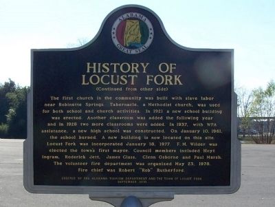
By David J Gaines, November 30, 2011
History of Locust Fork Marker, side B
| 1 ► Alabama, Blount County, Locust Fork — None — History of Locust Fork — |
| On Town Hall Road, on the left when traveling east. | |||
| 2 ► Alabama, Covington County, Andalusia — History of the Library / Andalusia Post Office becomes Public Library — |
| On South 3 Notch Street at Dunson Street, on the right when traveling south on South 3 Notch Street. | |||
| 3 ► Alabama, Etowah County, Gadsden — Gadsden Amphitheater — |
| On South 1st Street south of Walnut Street, on the right when traveling north. | |||
| 4 ► Alabama, Etowah County, Gadsden — Gadsden Municipal Amphitheatre — (Legion Park Bowl) — |
| On South 1st Street, on the right when traveling north. | |||
| 5 ► Alabama, Jefferson County, Birmingham — Building The Park — Visiting the Park — Restoring Vulcan Park — |
| Near Valley View Drive west of Richard Arrington Jr Boulevard South. | |||
| 6 ► Alabama, Jefferson County, Birmingham — Lane Park — |
| On Cahaba Road at Park Lane, on the right when traveling north on Cahaba Road. | |||
| 7 ► Alabama, Jefferson County, Birmingham — The Works Progress Administration |
| Near Valley View Drive west of Richard Arrington Jr Boulevard South. Reported unreadable. | |||
| 8 ► Alabama, Montgomery County, Montgomery — Montgomery City Hall / Funeral for Hank Williams — |
| On North Perry Street at Monroe Street, on the left when traveling south on North Perry Street. | |||
| 9 ► Alabama, Morgan County, Decatur — Beauty and Hope — Restoring the Vision...Preserving The Legacy — |
| On Prospect Drive at 7th Street, on the right when traveling west on Prospect Drive. | |||
| 10 ► Alabama, Morgan County, Decatur — Carolyn Cortner Smith — Female Architect Pioneer / Designed Delano Park Structures — |
| On Gordon Drive Southeast at 8th Avenue Southeast, on the right when traveling east on Gordon Drive Southeast. | |||
| 11 ► Alabama, Shelby County, Montevallo — Montevallo High School — |
| On Oak Street, on the right when traveling north. | |||
| 12 ► Alabama, Shelby County, Montevallo — Welcome To Historic Montevallo — |
| On Main Street (State Highway 119) at Middle Street, on the right on Main Street. | |||
| 13 ► Alabama, Tuscaloosa County, Tuscaloosa — Queen City Park — |
| Near Queen City Avenue east of Jack Warner Parkway, on the right when traveling east. | |||
| 14 ► Arizona, Apache County, Springerville — 18 — White Mountain Hospital — |
| On South Mountain Avenue, on the right when traveling north. | |||
| 15 ► Arizona, Cochise County, Bisbee — The Warren Ball Park — |
| On Arizona Street at Ruppe Avenue, on the right when traveling south on Arizona Street. | |||
| 16 ► Arizona, Cochise County, Naco — Bisbee Golf Club — |
| 17 ► Arizona, Cochise County, Willcox — The Willcox Women's Community Center — |
| On West Stewart Street south of North Austin Boulevard, on the left when traveling west. | |||
| 18 ► Arizona, Maricopa County, Phoenix, Camelback East Village — Hunt Bass Hatchery — |
| On North Mill Avenue, 0.2 miles east of North Galvin Parkway, on the right when traveling west. | |||
| 19 ► Arizona, Yavapai County, Prescott — City Park and Ballfield — |
| On Gurley Street (Arizona Route 89) at Washington Street., on the right on Gurley Street. | |||
| 20 ► Arizona, Yavapai County, Prescott — Grace M. Sparkes — 1893 – 1963 — |
| Near East Gurley Street east of North Arizona Avenue. | |||
| 21 ► Arizona, Yavapai County, Prescott — Prescott National Guard Armory — |
| Near East Gurley Street east of North Arizona Avenue. | |||
| 22 ► Arkansas, Mississippi County, Osceola — WPA Post Office — |
| On West Hale Avenue, on the right when traveling west. | |||
| 23 ► Arkansas, Newton County, Jasper — C-12 — Newton County — County Seat — |
| On Church Street just east of Stone Street (State Route 7), on the left when traveling east. | |||
| 24 ► California, Alameda County, Berkeley, Berkeley Hills — North Branch Berkeley Public Library — James W. Plachek, Architect, 1936 — |
| On The Alameda near Hopkins Street, on the right when traveling south. | |||
| 25 ► California, Alameda County, Berkeley, North Berkeley — Berkeley Municipal Rose Garden — City of Berkeley Landmark - Designated in 1995 — Vernon M. Dean, Landscape Architect - 1933-1937 — |
| Near Euclid Avenue near Eunice Street. | |||
| 26 ► California, Alameda County, Oakland, Grand Lake — Morcom Amphitheater of Roses — |
| On Jean Street west of Grand Avenue, on the right when traveling west. | |||
| 27 ► California, Alameda County, Oakland, Joaquin Miller Park — The Creation of a Park — |
| Near Sanborn Drive near Joaquin Miller Road, on the left when traveling north. | |||
| 28 ► California, Contra Costa County, Richmond — Alvarado Park — |
| Near McBryde Avenue at Park Avenue. | |||
| 29 ► California, Contra Costa County, Richmond — Alvarado Park — |
| On Park Avenue north of McBryde Avenue. | |||
| 30 ► California, Kern County, Taft — The Fort — Replica of Sutter’s Fort — Erected in 1940 A.D. — |
| On North 10th Street, on the right when traveling north. | |||
| 31 ► California, Los Angeles County, Altadena — Farnsworth Park — Works Progress Administration — |
| Near Mount Curve Avenue East at Lake Avenue, on the left when traveling west. | |||
| 32 ► California, Los Angeles County, Beverly Hills — Beverly Hills High School — Swim Gym — 1939 — |
| On Moreno Drive, 0.1 miles north of Olympic Boulevard, on the left when traveling north. | |||
| 33 ► California, Los Angeles County, La Crescenta-Montrose, Montrose — The Great Flood of 1934 — |
| On Rosemont Avenue at Fairway Avenue, on the right when traveling north on Rosemont Avenue. | |||
| 34 ► California, Los Angeles County, La Verne — La Verne Heights Elementary School — |
| On Baseline Road, 0.1 miles east of Wheeler Avenue, on the right when traveling east. | |||
| 35 ► California, Los Angeles County, Long Beach, Downtown Core — 17 — Recreation — |
| On East 3rd Street, on the right when traveling west. | |||
| 36 ► California, Los Angeles County, Long Beach, East Village — Long Beach Post Office — |
| On Long Beach Boulevard, on the right when traveling north. | |||
| 37 ► California, Los Angeles County, Los Angeles, Cahuenga Pass — Barham Blvd Bridge — |
| On Barham Boulevard at U.S. 101, on the right when traveling south on Barham Boulevard. | |||
| 38 ► California, Los Angeles County, Los Angeles, Canoga Park — Assembly Hall — Canoga Park High School — |
| On Topanga Canyon Boulevard at Vanowen Street, on the right when traveling north on Topanga Canyon Boulevard. | |||
| 39 ► California, Los Angeles County, Los Angeles, Canoga Park — Canoga Park Post Office — Challenger Station — |
| On Sherman Way at Jordan Avenue, on the right when traveling west on Sherman Way. | |||
| 40 ► California, Los Angeles County, Los Angeles, Chinatown — Vignes Street Grade Separation — |
| On Vignes Street, 0.1 miles east of Main Street, on the right when traveling east. | |||
| 41 ► California, Los Angeles County, Los Angeles, Downtown Los Angeles — Macy Street Grade Separation — Cesar Chavez Avenue — |
| On Cesar E Chavez Avenue east of Alameda Street, on the right when traveling east. | |||
| 42 ► California, Los Angeles County, Los Angeles, Downtown Los Angeles — Temple Street Grade Separation — |
| On Temple Street at Figueroa Street, on the right when traveling west on Temple Street. | |||
| 43 ► California, Los Angeles County, Los Angeles, Echo Park — 972 — Naval and Marine Corps Reserve Center — Los Angeles — |
| On Stadium Way west of California Route 110, on the right when traveling west. | |||
| 44 ► California, Los Angeles County, Los Angeles, Echo Park — Queen of the Angels — Lady of the Lake — Nuestra Reina de Los Angeles — |
| Near Park Avenue east of Glendale Boulevard, on the right when traveling east. | |||
| 45 ► California, Los Angeles County, Los Angeles, Franklin Canyon — Upper Franklin Canyon Reservoir — Exact Center of Los Angeles — |
| On Franklin Canyon Drive, 0.7 miles south of Mulholland Drive. | |||
| 46 ► California, Los Angeles County, Los Angeles, Glassell Park — Washington Irving Junior High School — Irving STEAM Magnet School — |
| On Estara Avenue at Fletcher Drive, on the right when traveling south on Estara Avenue. | |||
| 47 ► California, Los Angeles County, Los Angeles, Griffith Park — 100 Years of Golf in Griffith Park — 1914-2014 — |
| Near Griffith Park Drive, 1 mile north of Crystal Springs Drive, on the right when traveling north. | |||
| 48 ► California, Los Angeles County, Los Angeles, Griffith Park — Riverside Drive - Zoo Drive Bridge — |
| On Riverside Drive north of Zoo Drive, on the right when traveling north. | |||
| 49 ► California, Los Angeles County, Los Angeles, Griffith Park — 910 — Riverside Drive Bridge — |
| On Riverside Drive north of Zoo Drive, on the right when traveling north. | |||
| 50 ► California, Los Angeles County, Los Angeles, Griffith Park — 942 — Site of the Old Zoo — Griffith Park - Los Angeles — |
| Near Griffith Park Drive west of Crystal Springs Drive. | |||
| 51 ► California, Los Angeles County, Los Angeles, Lincoln Heights — 156 — Fire Station No. 1 — |
| On Pasadena Avenue at Avenue 23, on the right when traveling east on Pasadena Avenue. | |||
| 52 ► California, Los Angeles County, Los Angeles, Mid City — Los Angeles Center for Advanced Studies — Louis Pasteur Junior High School — |
| On 18th Street, 0.1 miles west of Fairfax Avenue, on the right when traveling west. | |||
| 53 ► California, Los Angeles County, Los Angeles, Northeast Los Angeles — Florence Nightingale Junior High School — |
| On Figueroa Street just north of Cypress Avenue, on the left when traveling north. | |||
| 54 ► California, Los Angeles County, Los Angeles, San Pedro — San Pedro Post Office — |
| On Beacon Street at 9th Street, on the right when traveling south on Beacon Street. | |||
| 55 ► California, Los Angeles County, Los Angeles, Sun Valley — Roscoe Elementary School — 1939 — |
| On Strathern Street, 0.1 miles west of San Fernando Road, on the right when traveling west. | |||
| 56 ► California, Los Angeles County, Los Angeles, Sunland — Sunland Park — |
| On Foothill Boulevard, 0.1 miles west of Sunland Boulevard, on the right when traveling west. | |||
| 57 ► California, Los Angeles County, Los Angeles, Sylmar — Dexter Park — |
| On Dexter Park Road, 0.2 miles south of Kagel Canyon Road, on the right when traveling south. | |||
| 58 ► California, Los Angeles County, Los Angeles, Tujunga — Verdugo Hills High School — |
| Near Hillrose Street at Plainview Avenue, on the right when traveling east. | |||
| 59 ► California, Los Angeles County, Los Angeles, Van Nuys — Engine Company No. 39 — Federal Emergency Administration of Public Works — |
| On Sylvan Street, 0.1 miles east of Van Nuys Boulevard, on the left when traveling east. | |||
| 60 ► California, Los Angeles County, Los Angeles, Westlake — 1st Street Viaduct — Over Glendale Boulevard — |
| On Toluca Street just north of 2nd Street, on the right when traveling north. | |||
| 61 ► California, Los Angeles County, Los Angeles, Westwood — Los Angeles National Cemetery — Veterans Administration Center — |
| Near Sepulveda Boulevard, 0.3 miles north of Wilshire Boulevard. | |||
| 62 ► California, Los Angeles County, Pasadena, North Central — Washington Park — Pasadena — |
| Near Washington Boulevard at El Molino Avenue, on the left when traveling west. | |||
| 63 ► California, Los Angeles County, Pomona — Millard Sheets Gallery — |
| Near McKinley Avenue, 0.5 miles east of Fairplex Drive. | |||
| 64 ► California, Los Angeles County, Santa Monica — City Hall — Santa Monica Landmark — |
| On Main Street at Interstate 10, on the left when traveling south on Main Street. | |||
| 65 ► California, Orange County, Fullerton — 19 — Fullerton College — |
| On Chapman Avenue west of Lemon Street, on the right when traveling west. | |||
| 66 ► California, Orange County, Fullerton — 11 — Fullerton Library — |
| On Pomona Avenue at Wilshire Avenue, on the left when traveling north on Pomona Avenue. | |||
| 67 ► California, Placer County, Auburn — The Historic Cooper Amphitheater — |
| Near High Street east of College Way, on the left when traveling east. | |||
| 68 ► California, San Bernardino County, Ontario — Central School — El Morado Court Historic District — 1934 — |
| On G Street, 0.2 miles east of Euclid Avenue, on the left when traveling east. | |||
| 69 ► California, San Bernardino County, Redlands — 42 — San Bernardino Asistencia — |
| On Barton Road east of Nevada Street, on the right when traveling west. | |||
| 70 ► California, San Diego County, San Diego — 49 — Adobe Chapel of The Immaculate Conception — |
| On Conde Street, on the left when traveling south. | |||
| 71 ► California, San Diego County, San Diego — 7 — Mormon Battalion — |
| On Jackson Street. | |||
| 72 ► California, Santa Barbara County, Santa Barbara — Los Baños del Mar Pool — Opened April 1939 — |
| On Shoreline Drive at Castillo Street, on the left when traveling west on Shoreline Drive. | |||
| 73 ► California, Santa Clara County, San Jose, Downtown San Jose — Main Post Office — |
| On North 1st Street near West St. John Street, on the right when traveling south. | |||
| 74 ► California, Shasta County, Redding — Veterans Memorial Hall — |
| On Yuba St, on the left when traveling west. | |||
| 75 ► California, Ventura County, Fillmore — Bardsdale Bridge — 1939 — |
| Near Main Street, 0.1 miles east of Central Avenue, on the right when traveling east. | |||
| 76 ► California, Ventura County, Santa Paula — 143 — Isbell School — 1939 — |
| On 4th Street north of Harvard Boulevard, on the right when traveling north. | |||
| 77 ► Colorado, Adams County, Brighton — Historic City Hall — |
| Near East 160th Avenue (East Bridge Street) (State Highway 7) just east of South 4th Avenue (State Highway 2), on the right when traveling east. | |||
| 78 ► Colorado, Arapahoe County, Littleton — Littleton, Colorado Post Office — National Register of Historic Places — |
| Near South Prince Street just north of West Alamo Avenue, on the left when traveling north. | |||
| 79 ► Colorado, Jefferson County, Golden — Transportation — |
| On Washington Avenue Bridge, on the right when traveling north. | |||
| 80 ► Colorado, Jefferson County, Morrison — West Alameda Parkway / Dinosaur Ridge — Works Progress Administration — 1937 — |
| On Hog Back Road (County Road 93) at West Alameda Parkway, on the right when traveling north on Hog Back Road. | |||
| 81 ► Colorado, Kiowa County, Eads — Unity Lodge No. 142, A.F. & A.M. — Works Progress Administration — |
| On West 13th Street east of Slater Street, on the left when traveling east. | |||
| 82 ► Colorado, Larimer County, Fort Collins — Antoine Janis Cabin — |
| On Mathews Street, on the right when traveling north. | |||
| 83 ► Colorado, Larimer County, Fort Collins — Carnegie Library — |
| On Mathews Street, on the right when traveling north. | |||
| 84 ► Colorado, Lincoln County, Hugo — Hugo Municipal Pool — Works Progress Administration — 1938 — |
| On 4th Street (U.S. 287) at 6th Avenue, on the right when traveling north on 4th Street. | |||
| 85 ► Colorado, Logan County, Sterling — Original Building — Overland Trail Museum — |
| Near Overland Trail just east of U.S. 6, on the left when traveling east. | |||
| 86 ► Colorado, Montrose County, Montrose — Montrose County Jail — |
| On Townsend Avenue (U.S. 550) at 1st Street, on the left when traveling south on Townsend Avenue. | |||
| 87 ► Colorado, Prowers County, Lamar — Explore Big Timbers Region — |
| On Scenic U.S. 50/287 at State Highway 196, on the right when traveling west on U.S. 50/287Scenic . | |||
| 88 ► Colorado, Weld County, Platteville — Fort Vasquez Trading Post — 1835 — Welcome - Bienvenido - Bonjour — |
| On U.S. 85. | |||
| 89 ► Connecticut, Hartford County, Hartford, Clay Arsenal — Black Heroes in Hartford: Gwendolyn Clarke Reed — Actress, Playwright, Community Storyteller (1912 - 1974) — #HartfordBlackHeroes — |
| On Main Street south of Mahl Avenue, on the right when traveling south. | |||
| 90 ► Connecticut, New Haven County, New Haven, West River — Corporal Timothy Francis Ahearn — |
| On Ella T. Grasso Boulevard (Connecticut Route 34) at Derby Avenue, on the right when traveling south on Ella T. Grasso Boulevard. | |||
| 91 ► Delaware, New Castle County, Delaware City — Theatre — Fort Dupont — Shaped by History and Anchored in Nature — |
| On Sussex Avenue just east of Wingate Road, on the right when traveling west. | |||
| 92 ► Delaware, New Castle County, Wilmington, Mid-town Brandywine — United States Post Office, Court House and Custom House — |
| On East 11th Street (Delaware Route 52) west of North King Street (Business U.S. 13), on the left when traveling east. | |||
| 93 ► District of Columbia, Washington, Northwest Washington, Judiciary Square — DC Recorder of Deeds Building / WPA Era Murals — 515 D Street, NW — African American Heritage Trail, Washington DC — |
| On D Street Northwest west of 5th Street Northwest. | |||
| 94 ► District of Columbia, Washington, Northwest Washington, Smithsonian National Zoo — Art in the Park — |
| Near Olmsted Walk, 0.2 miles east of North Road, on the right when traveling east. | |||
| 95 ► District of Columbia, Washington, Southwest Washington, Joint Base Anacostia-Bolling (JBAB) — Bolling Air Force Base — |
| Near Arnold Avenue Southwest, 0.1 miles north of Tinker Street Southwest, on the left when traveling north. | |||
| 96 ► Florida, Franklin County, Carrabelle — Marvin N. Justiss Building — "Some say he built half of Carrabelle" — |
| On Avenue B South (Business U.S. 98) east of Marine Street, on the right when traveling west. | |||
| 97 ► Florida, Hernando County, Spring Lake — Spring Lake Community Center — 1938 — |
| On Spring Lake Highway (County Road 541) south of Old Spring Lake Road, on the right when traveling north. | |||
| 98 ► Florida, Hillsborough County, Tampa — In the Beginning... — Uncle Sam Chooses Tampa for Base in 1939 — |
| On North Ashley Drive north of East Whiting Street, on the left when traveling north. | |||
| 99 ► Florida, Hillsborough County, Tampa — Middleton Senior High School — |
| On East Osborne Avenue east of North 22nd Street, on the left when traveling east. | |||
| 100 ► Florida, Hillsborough County, Tampa — The Bayshore Boulevard — |
| On Bayshore Boulevard at West Platt Street, on the right when traveling north on Bayshore Boulevard. | |||
479 entries matched your criteria. The first 100 are listed above. Next 100 ⊳