On Fall Hall Road at Wisconsin Highway 27, on the right when traveling west on Fall Hall Road.
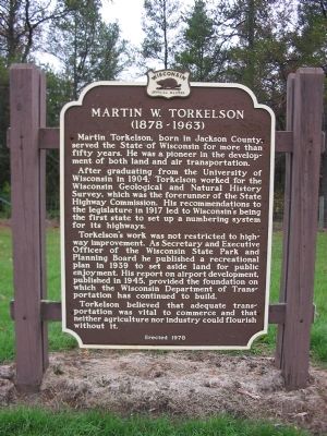
Martin Torkelson, born in Jackson County, served the State of Wisconsin for more than fifty years. He was a pioneer in the development for both land and air transportation.
After graduating from the University of Wisconsin in 1904, . . . — — Map (db m3477) HM
On State Highway 54, 4.5 miles east of Interstate 94, on the left when traveling east.
Corporal Mitchell Red Cloud was posthumously awarded the Congressional Medal of Honor for his courageous action in battle between U.S. troops and Chinese Communists near Chonghyon, Korea, Nov. 5, 1950. Red Cloud’s Company was entrenched beside Hill . . . — — Map (db m1865) HM
Near Interstate 94 at milepost 121, on the right when traveling west.
Huge flocks of passenger pigeons once roamed North America. Larger than the mourning dove which it resembled, the passenger pigeon derived its name from an Indian word meaning "wanderer" or one who moves from place to place. Flying at a normal speed . . . — — Map (db m3307) HM
On Interstate 94 at milepost 124, on the right when traveling east.
Marshy sections of Jackson, Monroe, Wood and Clark counties produce large quantities of Sphagnum moss, providing a major but little known state resource. The ability of Sphagnum to hold 20 times its weight in water makes it invaluable for keeping . . . — — Map (db m49765) HM
Near Interstate 94 at milepost 124, on the right when traveling east.
Winnebago Indians call themselves “Hochunkgra.” A Siouan people, they once occupied the southern half of Wisconsin and the northern counties of Illinois. The Black Hawk War of 1832 and a series of treaties forced the Winnebago out of . . . — — Map (db m3425) HM
Near Park Road, 0.1 miles north of U.S. 12, on the right when traveling north.
As a boy Ole Evinrude (1877-1934) lived near Cambridge. His father hoped to keep him on the farm and when Ole built a sailboat like he had seen in a picture book his father destroyed it. In a secret place in the woods the boy built another. Here on . . . — — Map (db m35297) HM
On County Route N, 2 miles south of Wisconsin Highway 106, on the left when traveling south.
A large Ho-Chunk (Winnebago) Village dating from the 1700s once stood in this vicinity. Just before the 1832 Black Hawk War, the village was burned during an intra-tribal battle. On July 6th and 8th, the United States Military camped at this site in . . . — — Map (db m31764) HM
On Milwaukee Avenue East, on the left when traveling east.
"Whilst lying here we have thrown up a stockade work flanked by four block houses for the security of our supplies and the accomodation of the sick," wrote General Henry Atkinson of this spot in his army report to General Winfield Scott on July 17, . . . — — Map (db m31765) HM
On Koshkonong Mounds Road, 1 mile west of Old Wisconsin Highway 26.
Between AD 650 and 1200, groups of Native Americans throughout the southern half of Wisconsin and portions of adjacent states built earthen mounds of various shapes and sizes, including mounds shaped like animals, today called effigy mounds. The 11 . . . — — Map (db m31766) HM
On Black Hawk Island Road, 3.2 miles west of Wisconsin Highway 106, on the left when traveling west.
Fish fowl flood Water lily mud My life in the leaves and on water My mother and I born in swale and swamp and sworn to water Lorine Niedecker (1903-70) lived on Black Hawk Island most of her life and . . . — — Map (db m32181) HM
On Riverside Drive (State Highway 106), on the left when traveling east.
Discovered in 1850 by Increase A. Lapham, this is the only known intaglio Effigy mound in the world. It was excavated for ceremonial purposes by American Indians of the Effigy Mound Culture about 1000 A.D. A part of the tail has been covered. Of ten . . . — — Map (db m82646) HM
In the old days when both automobiles and roads were few in number, it was easy for those who had cars to get far enough away from home to get lost. While there were some “trails” such as the Cannon Ball Trail and the Yellowstone Trail . . . — — Map (db m88574) HM
On Interstate 94, 3.5 miles west of Wisconsin Highway 26, on the right when traveling west.
Wisconsin contributed significantly to the military activities of the United States since it became a state in 1848. During the Civil War, for instance, Wisconsin made a major contribution to support the Union. About 50% of Wisconsin’s adult male . . . — — Map (db m37216) HM
On County Road Q, 0.3 miles south of County Road B, on the left when traveling south.
Indian people lived at Aztalan between AD 900 and 1200. The village encompassed 20 acres and was well-planned. The inhabitants planted corn, beans and squash, hunted wild game, fished and collected native plants for food. An elite group of . . . — — Map (db m37429) HM
On Interstate 94, 1 mile east of Wisconsin Highway 89, on the right when traveling east.
This is glaciated country. Here, as you approach the western edge of Wisconsin’s kettle moraine, you see many land features created by glacial ice some 15,000 years ago. Among the most interesting of these are long, oval hills known as drumlins. . . . — — Map (db m37215) HM
Near County Highway Q at County Highway B, on the left when traveling south.
Ancient people built this mound to mark a young woman's grave. The mound was the last in a line that once bordered the western side of the ancient community of Aztalan and the only one that contained a burial. Her community placed the young woman on . . . — — Map (db m35479) HM
On County Route H, 0.2 miles north of Young Road. Reported missing.
During the Black Hawk War of 1832, General Atkinson camped near this location on two occasions. On July 7th, Atkinson led his entire militia, including future President's Abraham Lincoln and Zachary Taylor here. On July 19th, Atkinson returned . . . — — Map (db m31762) HM
The first kindergarten in the United States was founded by Margarethe Meyer Schurz in this building in 1856. Moved to the present site and restored in 1956 by the Watertown Historical Society. — — Map (db m35450) HM
Near Milwaukee Street, 0.1 miles north of Rock River.
One of the nation’s most innovative bridge designers of the 20th century, Daniel B. Luten, designed the Milwaukee Street Bridge. Constructed in 1930 by Eau Claire Engineering, the bridge was a rare example of a steel-reinforced, three span, . . . — — Map (db m35452) HM
On Charles Street at Sunset Drive, on the right when traveling north on Charles Street.
This 8 sided five story house of solid brick construction was built in the early 1850s by pioneer John Richards. It is the best example in Wisconsin of an unusual architectural design which was in vogue briefly before the Civil War. It was claimed . . . — — Map (db m35454) HM
This barn was built by an early settler in 1853 was used by regional farmers driving cattle to the Milwaukee market over the Milwaukee-Watertown Plank Road. It was moved from the Plank road area east of the Rock River to this site in 1963 and . . . — — Map (db m223762) HM
On East Main Street at Rock River, on the right when traveling east on East Main Street.
On July 18th, during the Black Hawk War of 1832, Little Thunder – a Ho-Chunk (Winnebago) Indian guide to the U.S. Militia – discovered Black Hawk’s Band crossed the Rock River in this vicinity. After receiving the news, Gen. James D. . . . — — Map (db m35453) HM
On County Highway C north of Interstate 90/94, on the right when traveling east.
You are standing on what was once the bottom of a glacial lake in which Castle Rock, the formation rising before you, was an island. Thousands of years of erosion by water, ice and wind created the surface features you see in this area.
The . . . — — Map (db m4230) HM
Following the Civil War, state officials reorganized the Wisconsin Militia and in 1879 renamed it the Wisconsin National Guard. Adjutant General Chandler P. Chapman of Madison, a veteran of the famed Iron Brigade, purchased 440 acres near the . . . — — Map (db m31744) HM
On Main Street (State Highway 71) 0.5 miles west of Academy Street (State Highway 80/82), on the right when traveling west.
This 32 mile state trail was formerly the mainline of the Chicago and North Western Railway. The conversion from “rail to trail” represented a new concept in recreational development. Utilizing the abandoned railbed, it was the first . . . — — Map (db m18708) HM
On North Wisconsin Street (County Highway HH) north of West Julius Street (County Highway N), on the right when traveling south.
“Keep hopping, hoeing and hoping” said an editorial in 1867 when hops were selling for 50¢ a pound, pickers by the thousands worked in the fields, merchants were selling silks, laces, paisley shawls and grand pianos, and farmers were . . . — — Map (db m52853) HM
Near Interstate 90/94 at milepost 74, on the right when traveling east.
The Iron Brigade became one of the most celebrated units of the Civil War (1861-1865). Of its five regiments, three came from Wisconsin: the Second, Sixth, and Seventh Wisconsin Volunteer Infantry. (The other two regiments were the Nineteenth . . . — — Map (db m4119) HM
Near Interstate 90/94 at milepost 74, on the right when traveling east.
From its source at Lac Vieux Desert to the Mississippi River at Prairie du Chien, the Wisconsin River descends 1,071 feet in 430 miles. Twenty-six power dams utilize 640 feet of the fall of the river to produce an annual average of one billion . . . — — Map (db m4132) HM
Near Interstate 90/94 at milepost 75, on the right when traveling west.
“There are some who can live without wild things, and some who cannot.” For those who cannot, Aldo Leopold’s A Sand County Almanac helps reveal the unsuspected natural riches hidden in these sand counties of Wisconsin.
At . . . — — Map (db m4227) HM
On 56th Street at 24th Avenue, on the left when traveling west on 56th Street.
Thomas B. Jeffery purchased the 1895 Sterling Bicycle Factory and pioneered Kenosha’s auto industry in 1900. His company was an industry leader, creating the second mass produced auto in 1902. Jeffery was the first auto manufacturer to make all . . . — — Map (db m38570) HM
John McCaffary was hanged in Kenosha on August 21, 1851, for the murder of his wife and buried here in an unmarked grave. Public outrage over his execution resulted in legislation that abolished the death penalty in Wisconsin on July 12, 1853. — — Map (db m38121) HM
As early as 1795, the Potawatomi had a mile-long village on the Pike River near here. Fur trader Jacques Vieau Sr.’s son, Peter, wrote the village was called “Kee-neau-sha-Kau-ning,” meaning “the pickerel’s abiding place,” and it “was noted for the . . . — — Map (db m189972) HM
Kemper Hall, boarding school for girls, dates to 1855 when St. Matthew’s Episcopal Church and some dedicated Kenosha citizens signed a charter launching the Kenosha Female Seminary. In 1865, the school moved to this site, the home of U.S. Senator . . . — — Map (db m38122) HM
On Lighthouse Drive, on the left when traveling south.
Built by the federal government in 1866, the Kenosha Lighthouse replaces two other lighthouses constructed at this site in 1848 and 1858. Originally designated a coast and harbor light for Southport, now Kenosha, WI provided the first navigational . . . — — Map (db m147376) HM
On 7th Avenue at 61st Steet, on the left when traveling north on 7th Avenue.
Deming was born in Vermont in 1789 and came to the Village of Southport, later renamed Kenosha, in 1836. Deming was a Methodist preacher and a staunch supporter of the anti-slavery movement. For Methodists, slavery was considered the worst of social . . . — — Map (db m38119) HM
(Side A)
Born April 1757 in Stratford, CT, Abner Barlow moved to NH in 1772. At 20, Barlow enlisted as private in the NH Rangers, serving in Maj. Whitcomb’s Independent Corps at the Battle of Bennington and the surrender of Burgoyne, . . . — — Map (db m38240) HM
On 12th Street, 1 mile west of 136th Avenue, on the right when traveling west.
Over 12,000 years ago, Native Americans slaughtered a Northern Woolly Mammoth in a small lake near this site. Between 1992-93, the Kenosha Public Museum excavated the site and concluded that the woolly mammoth stood at 11 feet and weighed 14,000 . . . — — Map (db m38569) HM
Wisconsin women rallied to support the Union during the Civil War. They became nurses, hospital matrons, sanitary agents, and ministers. Cordelia A. Perrine Harvey attained national prominence for her role in promoting convalescent aid for sick and . . . — — Map (db m36392) HM
On Green Bay Road (State Highway 31) at 95th Street, on the right when traveling north on Green Bay Road.
Green Bay Road was the main route of settlement and communication in 19th century eastern Wisconsin. The road followed an ancient Indian trail network and was surveyed for use as a military road between Fort Dearborn (Chicago) and Fort Howard (Green . . . — — Map (db m66625) HM
On Interstate 94 at Wisconsin Highway 165 on Interstate 94.
In 1673, thirty-nine years after Jean Nicolet visited the Green Bay area, Father Jacques Marquette and Louis Jolliet set out from New France to explore the Mississippi River. They traveled from the Straits of Mackinac between lakes Huron and . . . — — Map (db m36671) HM
On State Highway 32, 0.5 miles north of State Highway 165, on the right when traveling north.
The 32nd Division was organized in 1917. Originally it was made up of National Guardsmen from Wisconsin and Michigan.
World War I: Fought in Alsace, Aisne-Marne, Olse-Aisne and Meuse-Argonne Offensives. Vanquished 23 German Divisions. Served in . . . — — Map (db m36339) HM
On 75th Street (State Highway 50) at 256th Avenue (State Highway 83), on the left when traveling west on 75th Street.
In the 1800’s, before assigning names to roads was a common practice, intersections were often given names to identify communities and places of interest.
The trail through Brass Ball Corners started at Lake Michigan and went west through Lake . . . — — Map (db m114066) HM
Near Hathaway Drive, on the right when traveling south.
Kewaunee, Green Bay & Western Railroad ferry slip No. 1, to your right, is the point where car-ferry service across Lake Michigan began. On Sunday, November 27, 1892, Ann Arbor Railroad car-ferry No. 1 loaded 22 cars of flour which originated at . . . — — Map (db m11760) HM
On County Highway D, 0.1 miles west of Knudson Road, on the left when traveling east.
The first college founded by Norwegian Lutheran pioneer immigrants in the United States opened in the parsonage of Halfway Creek Lutheran congregation, Sept. 1, 1861. Teachers were Laur. Larsen and F.A. Schmidt, who also served as pastors for area . . . — — Map (db m178493) HM
Near Interstate 90 at milepost 1 west of Lakeshore Drive, on the right when traveling east.
Cadwallader Colden Washburn was born in Maine in 1818. He settled in Mineral Point, Wisconsin, in 1839 and served in Congress before moving to La Crosse.
When the Civil War broke out, Washburn organized the Second Wisconsin Volunteer Cavalry . . . — — Map (db m15505) HM
On Powell Street south of Saint Andrew Street, on the left when traveling south.
This park, on the site of a Winnebago village, commemorates an heroic descendant of those people, Corporal Mitchell Red Cloud, Jr. Fighting in Korea in 1950 as a member of the 24th Army Division, Corporal Red Cloud bravely held off an enemy attack . . . — — Map (db m8534) HM
On State Street at Front Street North, on the right when traveling west on State Street.
Because of the fertile soil and lush woodlands on the river shores, the Winnebago Indians settled in this area in 1772. Sixty years later they ceded these lands to the U.S. Government. In 1842, Nathan Myrick, the first white settler in La Crosse, . . . — — Map (db m8538) HM
On State Highway 33 at Lost Ridge Road/Strittmater Road on State Highway 33.
Coulee is a term derived from the French verb "couler," meaning to flow. The area before you and in the entire coulee region of west central Wisconsin has been dissected by water erosion into a series of narrow ridges separated by steep-sided . . . — — Map (db m33420) HM
Near Interstate 90 at milepost 1 west of Lakeshore Drive, on the right when traveling east.
From Lake Itasca, Minnesota, to Cairo, Illinois, the upper Mississippi River flows through America's heartland for over 1100 miles. Its currents have borne the Indian's canoe, the explorer's dugout, and the trader's packet. Jacques Marquette, Louis . . . — — Map (db m15594) HM
Near State Highway 16, 0.3 miles north of State Highway 157, on the right when traveling east.
This is the location of a village occupied between 1000 and 1200 by the Oneota, ancestors of the Winnebago and Ioway. The village site was chosen by the Oneota to make the best use of the area for farming, fishing, hunting, transportation, and . . . — — Map (db m15402) HM
On Amsterdam Prairie Road, 1.5 miles north of Great River Road (State Highway 35), on the left when traveling north.
In the early 1850s Scottish immigrant Alexander McGilvray established a small settlement and ferry service, both known as "McGilvray's Ferry," along the Black River. For the next forty years the ferry made seasonal river crossings despite frequent . . . — — Map (db m54581) HM
On State Highway 16 east of State Highway 108, on the right when traveling east.
Gifted author of this region, Hamlin Garland was born at West Salem September 14, 1860, and died March 4, 1940. His ashes rest in the Garland family plot in Neshonoc cemetery, heart of the Coulee Country immortalized in his books, “Trailmakers . . . — — Map (db m8918) HM
On State Highway 16 east of State Highway 108, on the left when traveling east.
The nearby limestone grist mill and dam are the remnants of what once was a mid-19th century village located at this site. Vermont millwright and speculator Monroe Palmer purchased fifteen acres of land on the La Crosse River and constructed the dam . . . — — Map (db m23417) HM
On N. State Street (Wisconsin Route 78) 0.1 miles north of Grant St., on the right when traveling south.
This is the surviving portion of Argyle’s oldest existing house, built by John Z. Saxton and J.S. Waddington in 1850. Robert M. LaFollette lived here for ten years after his mother married Saxton in 1862. “Fighting Bob” LaFollette rose to become . . . — — Map (db m229772) HM
On County Route G at County Route B, on the right when traveling west on County Route G.
On January 14, 1998, the Wisconsin Assembly met at the First Capitol in Belmont in honor of the Sesquicentennial of Statehood. The Territorial Legislature held its first session here in 1836, and convened for three more sessions in what is now . . . — — Map (db m55046) HM
On County Route G at County Route B, on the right on County Route G.
When Governor Henry Dodge addressed the joint session of the legislature here on October 25, 1836, the Territory of Wisconsin included all of present day Wisconsin, Iowa, Minnesota, and parts of the two Dakotas. The population was about equally . . . — — Map (db m33129) HM
On County Route G at County Route B, on the right on County Route G.
On January 14, 1998, Governor Tommy G. Thompson addressed the Wisconsin Assembly at Wisconsin's First Territorial Capitol in Belmont in honor of the Sesquicentennial of Statehood. Serving more terms than any other governor in the history of . . . — — Map (db m33130) HM
On State Highway 11, 0.3 miles west of Ridge Avenue, on the right when traveling west.
In 1835 Father Samuel Mazzuchelli, Dominican missionary, came to the lead region from the Green Bay-Mackinac frontier. One year later he addressed the opening session of the territorial legislature. Soon he was establishing schools and preparing . . . — — Map (db m55045) HM
On South Main Street (State Highway 78) at Mill Street, on the right when traveling south on South Main Street.
In 1843, the Cline and Newkirk families arrived in the area followed by the Wildermuths in 1846. All were related by marriage and drawn here by fertile land and the Pecatonica River. Disillusion with their current religion and family tragedies led . . . — — Map (db m32041) HM
On Oak Street (State Highway 78) at East Baker Street (County Road F), on the left when traveling north on Oak Street.
In 1850, Zenas Gurley, settled with his family in this area. His charisma and leadership drew other devout families to this area after he broke with Brigham Young because of his polygamy practices. This settlement was called “Zarahemla” . . . — — Map (db m33077) HM
On State Highway 11, 0.2 miles west of Big Cut Road, on the right when traveling east.
Grant, Iowa and Lafayette counties were once the center of a lead-mining boom. Indians had sold lead to early traders, but there were few white miners here in 1820. Mining brought in a large part of the 37,000 population credited to the three . . . — — Map (db m55044) HM
On County Route Y, 3 miles County Route M, on the left when traveling north.
Blackhawk Memorial Park is on the site of the Battle of Pecatonica, the first of three military engagements fought in present-day Wisconsin during the American-Indian conflict of 1832, known as the Black Hawk War. On June 16, 1832, following attacks . . . — — Map (db m68810) HM
On North Langlade Road, 0.3 miles south of Wisconsin Highway 52 / 64, on the left when traveling south.
This plain was made thousands of years ago by rivers of water flowing from hills of melting glacial ice that lay a short distance north and east of here. The summer flood waters first laid down gravel, which was then covered by four feet of fertile . . . — — Map (db m36822) HM
By the 1920s, the once vast forests of Wisconsin had been reduced from more than 30 million acres to about 2 million through farm clearing and lumbering practices that left large cut-over areas. In 1927 the Wisconsin legislature passed the County . . . — — Map (db m33725) HM
On State Highway 55 north of State Highway 64, on the left when traveling north.
The Village of Langlade and Langlade County were named for Charles Michel de Langlade, who has been called the "Father of Wisconsin." Born at the trading post of Mackinac in 1729, de Langlade's character, military ability, and influence left a . . . — — Map (db m36825) HM
On State Highway 55, 3.7 miles north of State Highway 52 W, on the left when traveling north.
In March 1863 Abraham Lincoln signed an Act of Congress which enabled the states of Michigan and Wisconsin to begin construction of a road between Fort Howard at Green Bay and Fort Wilkins near Copper Harbor. It took one year to build the . . . — — Map (db m36896) HM
On East 2nd Street (State Highway 64) at East 1st Street (State Highway 64), on the left when traveling west on East 2nd Street.
Incorporated in 1883, Merrill built this City Hall in 1888–1889 for $16,275. The building was designed by architect T. D. Allen of Oshkosh, Wisconsin in the Richardsonian Romanesque style and was constructed of local brick, sandstone, and virgin . . . — — Map (db m224079) HM
On West 1st Street (State Highway 64) east of Grand Avenue (State Highway 107), on the right when traveling west.
This bridge was constructed in 1904 to replace a wooden - truss bridge and is a rare surviving example of a stone - arch bridge in Wisconsin. Plans for the new bridge were drawn up by city engineer Charles V. Sheldon. The current bridge features . . . — — Map (db m8591) HM
Near County Highway R, 0.5 miles north of Schley Road.
In 1847 New York millwright and speculator Pliney Pierce built this mill adjacent to the rapidly falling waters of Devils River. First constructed as a sawmill, Rock Mill was quickly converted to a gristmill after the area's available timber was . . . — — Map (db m223213) HM
Near Interstate 43 at milepost 168,, 4.1 miles north of County Highway Z, on the right when traveling north.
Since about 1840, the lakeshore area from Manitowoc to Sturgeon Bay has been a center for shipping, fishing, and shipbuilding on the upper Great Lakes. Early shipping was characterized by sail and steam vessels docking at small private piers . . . — — Map (db m22452) HM
On Memorial Drive, on the right when traveling north.
On January 8, 1928, Robert E. Burns of American Legion Post 165 held a special meeting to finalize plans for a public memorial honoring fallen service members of World War I. The plan was to plant a lane of trees on each side of the new . . . — — Map (db m179328) HM
Near Pinecrest Lane, 0.4 miles south of County Road JJ. Reported permanently removed.
This bridge was originally one of five spans that carried Collins Road over the Manitowoc River in the Town of Rockland. Built in 1911, it was replaced in 2001 and moved to Pinecrest Historical Village. This span is preserved to illustrate the . . . — — Map (db m48409) HM
Near Lakeview Drive (U.S. 10), on the left when traveling east.
(Side A)
Manitowoc and the Car Ferries. In the first five decades of the 20th century, Lake Michigan railroad car ferry service aided national defense and the regional economy by providing a key transportation alternative to the railroad . . . — — Map (db m11835) HM
Near Maritime Drive at North 7th Street, on the right when traveling east.
At the outbreak of World War II in 1939, President Franklin D. Roosevelt called upon America to rearm. Increasing the number of submarines became a goal. Because existing shipbuilders could not meet production schedules, the U.S. Navy approached . . . — — Map (db m12075) HM
On South 8th Street (U.S. 10) north of Quay Street, on the right when traveling north.
In 1847 Captain Joseph Edwards built the schooner Citizen here, beginning an era of maritime tradition in Manitowoc which has still not ended. The Challenge, believed one of the first clipper ships produced on the Great Lakes, was . . . — — Map (db m12073) HM
On U.S. 151, 0.9 miles west of Interstate 43, on the left when traveling west.
Many modern highways follow routes marked out long ago by Indian people. The Winnebago Trail across central Wisconsin became the general course of Highways 151 from Manitowoc to Fond du Lac, 45 from Fond du Lac to Oshkosh, 21 from Oshkosh . . . — — Map (db m32499) HM
Near Interstate 43 at milepost 168,, 2.5 miles south of Shirley Road (State Highway 96), on the right when traveling south.
The growth of the dairy industry in Wisconsin is a story of remarkable transfer of scientific knowledge to practical use. As dairy farming developed, Wisconsin's agriculture underwent transformation in less than 50 years.
Proposed as an . . . — — Map (db m10709) HM
Near Pioneer Road, 0.1 miles south of County Road XX. Reported permanently removed.
The Meeme Poll House, the official voting place in the Town of Meeme for 83 years, was erected by Joseph Schwartz and Edmund Kolb in 1900. German immigrants and their descendants exercised their democratic right to vote in this simple wooden . . . — — Map (db m36204) HM
On East Main Street (State Highway 147) 0.1 miles east of North State Street (County Road B), on the left when traveling east.
In 1847, Daniel Smith, a lumberman from New York, plotted a small village around his dam and sawmill on the river here, naming it for his friend Old Chief Mishicott. Old Chief Mishicott, a Potawatomi leader, is also the namesake of the Town of . . . — — Map (db m226255) HM
On West Main Street (County Road C) at South 1st Avenue, on the right when traveling west on West Main Street.
The George Washington School was built in 1893 at a cost of $1,800. It is believed to have once housed the largest collection of library books of any Manitowoc County rural school. The Village of St. Nazianz purchased the school in 1983 and . . . — — Map (db m46185) HM
On West Birch Street at South 3rd Avenue on West Birch Street.
In 1854, Fr. Ambrose Oschwald and a group of settlers emigrated from Baden, Germany to found a Catholic religious colony in the spirit of early Christians. This communal settlement was named St. Nazianz, after St. Gregory of Nazianzus from . . . — — Map (db m32327) HM
On Washington Street (State Highway 42) at 17th Street, on the right when traveling north on Washington Street.
In 1881, George Hallauer asked Edward C. Berner, the owner of a soda fountain at 1404 – 15th Street, to top a dish of ice cream with chocolate sauce, hitherto used only for ice cream sodas. The concoction cost a nickel and soon became very . . . — — Map (db m11772) HM
On Park Road near County Road O, on the left when traveling south.
On this prominent point of land, a major threat to navigation on Lake Michigan's western shore, Rawley Point Lighthouse was erected in 1894 and is the only one of its kind on the Great Lakes. The tower is a reconstruction and enlargement of an old . . . — — Map (db m57927) HM
On North Liberty Street (County Highway J) 0.1 miles north of North Calumet Street (U.S. 151), on the left when traveling north.
One of Wisconsin's most controversial figures, Thorstein Bunde Veblen, was born near here July 30, 1857. In 1865 the Veblen family moved to Minnesota where Thorstein graduated from college in 1880. He was a deep thinker, usually lonely and always in . . . — — Map (db m11633) HM
On Berlin Lane at Naugart Drive, on the right when traveling south on Berlin Lane.
In the 1850s, in the midst of Wisconsin's lumber boom, a large migration of Germans helped settle Marathon County. This group hailed from Pomerania, a former Prussian province in present-day northern Germany and Poland. Immigration continued for the . . . — — Map (db m86951) HM
On Kort Street west of West Grand Avenue, on the left when traveling west.
On June 23, 1911, near this location, Wausau native John Schwister became a pioneer of Wisconsin aviation. Research indicates that on this date Schwister flew the state's first home-built airplane capable of sustained, powered flight. Constructed . . . — — Map (db m6056) HM
On West Stewart Avenue (State Highway 52) at South 8th Avenue, on the right when traveling east on West Stewart Avenue.
Rural Teacher Training needs became apparent in Marathon County before the turn of the century. John F. Lamont, Marathon County School Superintendent, investigated the problem and urged Senator A. L. Kruetzer to introduce legislation in the 1887 . . . — — Map (db m87007) HM
Near Mcindoe Street, on the right when traveling north.
The Wisconsin Workmen's Compensation Act of 1911 assured victims of work-related accidents or illnesses just compensation regardless of fault. With this law, enacted on May 3, 1911, Wisconsin became the first state to have a constitutional system . . . — — Map (db m17859) HM
Constructed in 1911, Lena Road School is one of the few remaining intact one-room schoolhouses in Marinette County. The school grounds feature the original privies and an early hand water pump. For over fifty years, local farming families . . . — — Map (db m39248) HM
On Riverside Avenue north of U.S. 41, on the right when traveling west.
Marinette native John Hubley was born on May 21, 1914, and was inspired to become an artist by his mother and grandfather, both of whom were painters. Joining Disney to paint layouts in 1936, he found he disliked the studio’s ultra-realistic style . . . — — Map (db m224102) HM
On Oconto Avenue (County Highway B) west of Ellis Avenue, on the right when traveling west.
On the night of 0ctober 8, 1871, Peshtigo, a booming town of 1700 people, was wiped out of existence in the greatest forest fire disaster in American history.
Loss of life and even property in the great fire occurring the same night in Chicago . . . — — Map (db m120657) HM
On County Highway JJ, 0.3 miles east of Peterson Road, on the right when traveling east.
The term “graded school” was used to refer to any school that had more than one room and therefore contained more than one grade level of pupils. The McAllister State Graded School was built in 1914 and added to in 1919, 1924 and 1936. . . . — — Map (db m58569) HM
On State Highway 22, 0.6 miles north of Berry Road (County Highway CM), on the right when traveling north.
It was over this road that John Muir traveled to such early settlements as Kingston and Pardeeville. Muir was eleven when he came here from Scotland with his father, brother and sister in 1849. His mother arrived with her other children after a . . . — — Map (db m4029) HM
On U. S. Highway 51 (Interstate 39 at milepost 117), on the right when traveling north.
On June 25, 1950, Communist North Korea invaded the Republic of Korea. Backed by Soviet Russia, the North Koreans quickly overran most of the peninsula. South Korea appealed to the United States for assistance, and President Harry Truman immediately . . . — — Map (db m2788) HM
On Ember Avenue at 4th Avenue, on the left when traveling west on Ember Avenue.
Built in 1867, this one room rural school has served as the center of community life in Russell Flats for over 130 years. Constructed by Scotch - Irish settlers who arrived here in the early 1850s, the school has also functioned as the local . . . — — Map (db m20121) HM
On State Highway 47/55, 0.6 miles north of Strauss Road, on the right when traveling north.
When Nicolet in 1634 stepped ashore not far from the present site of Green Bay, the Menominees were living in peace with their neighbors on both sides of the Menominee River, on the present sites of Menominee, Michigan, and Marinette, Wisconsin. . . . — — Map (db m13622) HM
On State Highway 55 north of Spirit Rock Road, on the left when traveling north.
One night long ago a Menominee Indian dreamed that Manabush, grandson of Ko-Ko-Mas-Say-Sa-Now (the Earth) and part founder of the Mitawin or Medicine Society, invited him to visit the god. With seven of his friends the Indian called on Manabush who . . . — — Map (db m13602) HM
On West Grange Avenue, 0.5 miles west of South 76th Street, on the right when traveling east.
Born in Detroit to Irish immigrant parents, Curtin came to Milwaukee in 1837 to join his mother’s family the Furlongs and settle on a farm in Greenfield. In the 1840’s the Curtins moved into this typically Irish stone house described in Curtin’s . . . — — Map (db m34760) HM
On W. Grange Ave., 0.2 miles east of S. 92nd Street, on the right when traveling east.
Lime production was an important nineteenth century industry in southeastern Wisconsin, primarily because the region’s geology provided abundant Silurian dolomite rock that was easily quarried. High quality lime, used mainly in mortar and plaster, . . . — — Map (db m37508) HM
600 entries matched your criteria. Entries 201 through 300 are listed above. ⊲ Previous 100 — Next 100 ⊳