296 entries match your criteria. The first 100 are listed. ⊳
Sons of Confederate Veterans/United Confederate Veterans Historical Markers
Markers erected by or related to the Sons of Confederate Veterans (SCV), or their predecessor organization, the United Confederate Veterans (UCV).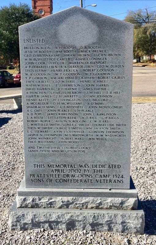
By Mark Hilton, December 17, 2013
Prattville Dragoons Monument (reverse)
| 1 ► Alabama, Autauga County, Prattville — Prattville Dragoons — |
| On South Washington Street at East 4th Street, on the right when traveling north on South Washington Street. | |||
| 2 ► Alabama, Barbour County, Midway — Fort Browder / 15th Alabama Infantry — |
| On U.S. 82 close to County Road 79, on the left when traveling west. | |||
| 3 ► Alabama, Cullman County, Cullman — Cullman County Confederate Memorial — |
| Near Sportsman Lake Road NW, 0.4 miles west of 2nd Avenue NW (Route 31). | |||
| 4 ► Alabama, Elmore County, Millbrook — Robinson Springs Camp Confederate Monument — |
| On Main Street (Alabama Route 143) at Monument Drive, on the right when traveling south on Main Street. | |||
| 5 ► Alabama, Elmore County, Wetumpka — The Wetumpka Light Guard — 1861 - 1865 — |
| On West Tuskeena Street at North Bridge Street (Alabama Route 111), on the left when traveling west on West Tuskeena Street. | |||
| 6 ► Alabama, Escambia County, Atmore — Canoe Station — |
| On U.S. 31 at Baker Street, on the right when traveling east on U.S. 31. | |||
| 7 ► Alabama, Etowah County, Gadsden — Turkey Town Monument — Chief Turkey-Turkey Town Valley Expedition-May We Never Forget — |
| On U.S. 411, on the right when traveling west. | |||
| 8 ► Alabama, Jefferson County, Birmingham — Forrest Camp No. 1435 — |
| On 60th Street North, in the median. | |||
| 9 ► Alabama, Jefferson County, Birmingham — United Confederate Veterans — |
| On 60th Street North, in the median. | |||
| 10 ► Alabama, Jefferson County, Birmingham — United Confederate Veterans — Camp Hardee No. 39 — |
| On Martin Luther King Drive, on the right when traveling south. | |||
| 11 ► Alabama, Lamar County, Vernon — Lamar County Confederate Memorial — |
| On Pond Street (Alabama Route 17) at 1st Avenue NE, on the right when traveling north on Pond Street. | |||
| 12 ► Alabama, Lawrence County, Moulton — Confederate Veterans Memorial — |
| On Court Street (County Route 460) east of Market Street (Alabama Route 33), on the right when traveling east. | |||
| 13 ► Alabama, Lee County, Auburn — The Auburn Guards Reviewed by Jefferson Davis — |
| On Mitcham Avenue at North Gay Street, on the right when traveling west on Mitcham Avenue. | |||
| 14 ► Alabama, Mobile County, Mobile — 10" Rifled Sea Coast Columbiad — |
| On Government Street, 0.1 miles east of South Royal Street, in the median. | |||
| 15 ► Alabama, Mobile County, Mobile — Admiral Raphael Semmes, CSA — 1861–1865 |
| On Government Street, in the median. Reported permanently removed. | |||
| 16 ► Alabama, Morgan County, Decatur — Lest We Forget — |
| Near Washington Street at Memorial Drive when traveling south. | |||
| 17 ► Alabama, Pike County, Troy — Confederate Memorial — |
| On South Three Notch Street (U.S. 29) south of Elm Street, on the left when traveling south. | |||
| 18 ► Alabama, St. Clair County, Ashville — Assassination Site of Sgt. E. Frank Harrison — |
| On 5th Street (U.S. 231) south of 9th Avenue, on the right when traveling south. | |||
| 19 ► Alabama, St. Clair County, Ashville — The Dean / Inzer House — Home of Lt. Col. / Judge John Washington Inzer — |
| On 5th Street (U.S. 411) at 7th Avenue, on the right when traveling south on 5th Street. | |||
| 20 ► Alabama, St. Clair County, Ohatchee — Battle of “Ten Islands” — ¼ mile above Neely Henry Dam — |
| Near State Highway 144. | |||
| 21 ► Alabama, Talladega County, Lincoln — Refuge Cemetery — |
| On Holly Hill Road (County Route 7), on the right when traveling south. | |||
| 22 ► Alabama, Tuscaloosa County, Tuscaloosa — Alabama Corps Of Cadets Defends Tuscaloosa — |
| On University Boulevard, on the right when traveling west. | |||
| 23 ► Arizona, Cochise County, Dragoon — Confederate Graves at Dragoon Springs — |
| 24 ► Arizona, Cochise County, Sierra Vista — Arizona Confederate Veterans Memorial — |
| On East Golf Links Road, 0.4 miles west of South Buffalo Soldier Trail, in the median. | |||
| 25 ► Arizona, Maricopa County, Phoenix, Central City — Arizona Confederate Veterans — 1861 1865 — |
| Near West Van Buren Street east of North 27th Avenue. | |||
| 26 ► Arkansas, Benton County, Bentonville — Confederate Memorial |
| On West Central Avenue at North Main Street, on the left when traveling east on West Central Avenue. Reported permanently removed. | |||
| 27 ► Arkansas, Boone County, Harrison — Boone County Confederate Memorial — |
| On North Main Street north of West Stephenson Avenue, on the left when traveling north. | |||
| 28 ► Arkansas, Craighead County, Jonesboro — Civil War Action in Western Craighead County — |
| On East Kings Highway (Arkansas Route 18/91) at Jacksonport Road (County Road 118), on the left when traveling east on East Kings Highway. | |||
| 29 ► Arkansas, Independence County, Batesville — Batesville Confederate Monument — |
| On East Main Street at Broad Street, on the left when traveling west on East Main Street. | |||
| 30 ► Arkansas, Lincoln County, Tyro — 81 — The Orphan Company — |
| Near Madison Road, 0.2 miles south of State Route 54. | |||
| 31 ► Arkansas, Newton County, Jasper — 111 — Civil War in Newton County / Newton County Civil War Troops — |
| On Court Street (State Highway 7) at Stone Street (State Highway 7), on the right when traveling east on Court Street. | |||
| 32 ► Arkansas, Pulaski County, Little Rock, Downtown — A Tribute to Gen. Thos. J. Churchill — C.S.A. — |
| Near West Markham Street at Ashley Street, on the right when traveling west. | |||
| 33 ► Arkansas, Pulaski County, Little Rock, Downtown — A Tribute to Gen. Wm. Read Scurry — C.S.A. — |
| Near West Markham Street at Ashley Street, on the right when traveling west. | |||
| 34 ► Arkansas, Pulaski County, Little Rock, Downtown — David Owen Dodd Memorial |
| Near West Markham Street at Ashley Street, on the right when traveling west. Reported permanently removed. | |||
| 35 ► Arkansas, Pulaski County, Little Rock, Downtown — To The Confederate Women of Arkansas — 1861-1865 — |
| On Woodlane Street north of West 6th Street, on the left when traveling north. | |||
| 36 ► Florida, Bay County, Panama City — F-425 — St. Andrew Skirmish |
| On West Beach Drive (Business U.S. 98) at Friendship Avenue, on the right when traveling east on West Beach Drive. Reported missing. | |||
| 37 ► Florida, Bay County, Panama City — F-477 — The St. Andrew Bay Saltworks — |
| On West Beach Drive (Business U.S. 98) at East Caroline Boulevard, on the right when traveling south on West Beach Drive. | |||
| 38 ► Florida, Clay County, Orange Park — Torpedo Warfare on the St. Johns River — |
| On Kingsley Avenue at River Road, in the median on Kingsley Avenue. | |||
| 39 ► Florida, Duval County, Jacksonville, Southwest Jacksonville — Skirmish at Cedar Creek — |
| On Lenox Avenue, 0.2 miles west of Lane Avenue S (State Road 103), on the right when traveling west. | |||
| 40 ► Florida, Duval County, Jacksonville, Springfield — Old Confederate Soldiers and Sailors Home — 1893-1938 — |
| Near E Union Street near N Washington Street. | |||
| 41 ► Florida, Duval County, Jacksonville, Urban Core — 1914 United Confederate Veterans Reunion — |
| On Main Street N (State Route 5) (U.S. 1), on the right when traveling north. | |||
| 42 ► Florida, Duval County, Jacksonville, Urban Core — The Monument to Women of the Southern Confederacy — |
| On Phelps Street near Hubbard Street, on the right when traveling east. | |||
| 43 ► Florida, Hillsborough County, Tampa — Confederate States Soldiers and Sailors — (Tampa) — |
| Near East Harrison Street near North Morgan Street. | |||
| 44 ► Florida, Hillsborough County, Tampa — Gen. Robert E. Lee, C.S.A. |
| On North Ashley Drive south of East Twiggs Street, on the left when traveling north. Reported missing. | |||
| 45 ► Florida, Hillsborough County, Tampa — John T. Lesley Home — |
| On East Street, on the right when traveling north. | |||
| 46 ► Florida, Hillsborough County, Tampa — Union Raiders Burn Tampa Blockade Runners — |
| Near North Boulevard south of West Clinton Street, on the left when traveling north. | |||
| 47 ► Florida, Jefferson County, Monticello — Confederate Memorial — |
| Near West Washington Street (Florida Route 10) at North Hickory Street. | |||
| 48 ► Florida, Miami-Dade County, Miami — F-788 — Miami City Cemetery — |
| Near Northeast 2nd Avenue at Northeast 18th Street, on the right when traveling south. | |||
| 49 ► Florida, Polk County, Bartow — Co E 7th Florida Inf Regt South Florida Bulldogs — CSA — 1861 – Deo Vindice – 1865 |
| On East Main Street east of Broadway Avenue, on the left when traveling east. Reported missing. | |||
| 50 ► Florida, Polk County, Fort Meade — Lt. Gen. Thomas J. "Stonewall" Jackson Memorial — 1861 – Deo Vindice – 1865 — |
| On 3rd Street Northeast east of North Cleaveland Avenue, on the left when traveling east. | |||
| 51 ► Florida, Sumter County, Wildwood — Oak Grove Cemetery Confederate Veterans Memorial — |
| Near County Road 232 west of County Road 221. | |||
| 52 ► Florida, Volusia County, Daytona Beach — Confederate Veterans |
| On North Beach Street north of International Speedway Boulevard (U.S. 92). Reported permanently removed. | |||
| 53 ► Florida, Volusia County, Ormond Beach — Confederate States of America Veterans at Rest Here — Pilgrims Rest Cemetery — |
| On West Granada Boulevard (Florida Route 40) 0.1 miles east of South Nova Road (Florida Route 5A), on the right when traveling west. | |||
| 54 ► Georgia, Bartow County, Cartersville — Pierce Manning Butler Young, (1836-1896) — |
| Near North Erwin Street, 0.1 miles east of Cassville Road (Georgia Route 293). | |||
| 55 ► Georgia, Ben Hill County, Fitzgerald — 009-1 — Gen. Bush's Home — ←——« — |
| On West Suwanee Street, 0 miles west of North Gordon Street, on the left when traveling west. | |||
| 56 ► Georgia, Berrien County, Nashville — The War Between the States — 1861-1865 — |
| On Jefferson Street just south of East Marion Avenue (State Route 76), on the right when traveling south. | |||
| 57 ► Georgia, Carroll County, Carrollton — Dixie Street — From 1865 — |
| On Dixie Street, 2 miles south of West Avenue, on the left when traveling south. | |||
| 58 ► Georgia, Chatham County, Tybee Island — Immortal Six Hundred — |
| Near Fort Pulaski Road, on the right when traveling north. | |||
| 59 ► Georgia, Colquitt County, Moultrie — Olde Greenfield Church and Historic Cemetery — In Memory of Rev. T.C. Gregory — |
| On Greenfield Church Road at Kilgore Road, on the left when traveling east on Greenfield Church Road. | |||
| 60 ► Georgia, Fulton County, Atlanta, Inman Park — Brig. Gen. A. M. Manigault’s Brigade — |
| On Waverly Way at Edgewood Avenue, on the right when traveling north on Waverly Way. | |||
| 61 ► Georgia, Jeff Davis County, Hazlehurst — Jefferson Davis Memorial — |
| On South Tallahassee Street (U.S. 23/221) at Jeff Davis Street, on the left when traveling south on South Tallahassee Street. | |||
| 62 ► Georgia, Johnson County, Wrightsville — Confederate Memorial — Johnson County , Georgia — |
| On East Elm Street (U.S. 319) near North Marcus Street (State Highway 57), on the right when traveling west. | |||
| 63 ► Georgia, Montgomery County, Mt. Vernon — Montgomery County Confederate Monument — |
| On McEachin Street (U.S. 221). | |||
| 64 ► Georgia, Muscogee County, Columbus — Confederate Siege Gun — National Civil War Naval Museum — |
| 65 ► Georgia, Muscogee County, Columbus — Moses Dallas: Confederate Naval Pilot/American Slave — |
| Near Victory Drive (U.S. 280) at Lumpkin Boulevard. | |||
| 66 ► Georgia, Putnam County, Eatonton — Putnam County Confederate Monument — |
| On Marion Street at Madison Avenue, in the median on Marion Street. | |||
| 67 ► Georgia, Richmond County, Augusta — This Memorial — |
| On 2nd Street, on the right when traveling north. | |||
| 68 ► Georgia, Terrell County, Dawson — 135-2 — Gen. Patrick Cleburne Camp, S.C.V. — |
| On North Main Street, 0 miles 7th Avenue NE, on the right when traveling north. | |||
| 69 ► Georgia, Toombs County, Vidalia — McMillan Burial Ground — |
| On Church Street just south of East 2nd Street, on the right when traveling south. | |||
| 70 ► Georgia, Toombs County, Vidalia — To Commemorate the 100th Anniversary of the Sons of Confederate Veterans — 1896-1996 — |
| Near Church Street just south of East 2nd Street, on the right when traveling south. | |||
| 71 ► Georgia, Toombs County, Vidalia — Unknown Confederate Graves — |
| Near Church Street just south of East 2nd Street, on the right when traveling south. | |||
| 72 ► Georgia, Twiggs County, Jeffersonville — Twiggs County Civil War Monument — |
| On North Railroad Street just south of Magnolia Street (State Route 96), on the left when traveling south. | |||
| 73 ► Georgia, Walker County, Suttles Mill — William Little House — |
| On West Armuchee Road at Manning Mill Road on West Armuchee Road. | |||
| 74 ► Georgia, White County, Cleveland — Mustering Grounds — |
| Near Courthouse Square (North Main Street) (U.S. 129) at East Jarrard Street, on the left when traveling south. | |||
| 75 ► Illinois, Cook County, Chicago, Greater Grand Crossing — Confederate Mound Monument — |
| Near East 67th Street at South Greenwood Avenue, on the right when traveling east. | |||
| 76 ► Indiana, Franklin County, Laurel — 24.2006.1 — Brigadier General CSA Francis Asbury Shoup — |
| On State Road 121 at High Street, on the left when traveling north on State Road 121. | |||
| 77 ► Iowa, Davis County, Bloomfield — The Confederate Invasion of Iowa Monument — |
| On South West Street, 0.3 miles south of Karr Avenue, on the left when traveling south. | |||
| 78 ► Iowa, Van Buren County, Bentonsport — Iowa’s Confederate General — |
| On Main Street (County Road J 40), on the right. | |||
| 79 ► Kansas, Linn County, Pleasanton — Battle of Mine Creek — October 25, 1864 — |
| Near State Highway 52. | |||
| 80 ► Kentucky, Bracken County, Augusta — Augusta Confederate Monument — |
| Near Heather Renee French Boulevard (State Highway 8) 0.2 miles west of Park View Street, on the right when traveling west. | |||
| 81 ► Kentucky, Hart County, Munfordville — 1504 — Battle of Rowletts Station — |
| On S. Dixie Highway (U.S. 31W) 0.2 miles south of Charlie Dowling Road, on the left when traveling south. | |||
| 82 ► Kentucky, McLean County, Calhoun — Camp Calhoun — |
| On West 3rd Street west of Poplar Street, on the right when traveling west. | |||
| 83 ► Kentucky, McLean County, Calhoun — Camp Calhoun Cemetery — |
| On West 3rd Street west of Poplar Street, on the right when traveling west. | |||
| 84 ► Kentucky, Pulaski County, Nancy — "Confederate Mass Grave" — |
| Near Kentucky Route 235, 0.1 miles south of Kentucky Route 761, on the left when traveling south. | |||
| 85 ► Louisiana, De Soto Parish, Keatchie — Confederate Cemetery — |
| On Louisiana Route 172, 0.1 miles east of Lucky Lane, on the right when traveling east. | |||
| 86 ► Maryland, Washington County, Boonsboro — Near Here in Wise’s Field — |
| On Reno Monument Road at the Appalachian Trail, on the left when traveling west on Reno Monument Road. | |||
| 87 ► Mississippi, Chickasaw County, Houston — Chickasaw County CSA Monument — |
| On E. Madison Street at N. Jackson Street, on the right when traveling west on E. Madison Street. | |||
| 88 ► Mississippi, Greene County, Leakesville — Confederate Veterans of Greene County — 1861 CSA 1865 — |
| On Main Street (Mississippi Route 63/57) at Lafayette Avenue, on the right when traveling west on Main Street. | |||
| 89 ► Mississippi, Hinds County, Jackson — Monument to Women of the Confederacy — |
| On Mississippi Street at North Congress Street, in the median on Mississippi Street. | |||
| 90 ► Mississippi, Lauderdale County, Meridian — Charles W. "Savez" Read — Naval Hero of the Confederacy — |
| Near 40th Avenue south of 8th Street. | |||
| 91 ► Mississippi, Leflore County, Greenwood — Confederate Memorial Plot — |
| Near 1st Street, 0.1 miles south of Strong Avenue, on the left when traveling south. | |||
| 92 ► Mississippi, Warren County, Vicksburg — Confederate Dead at Vicksburg Memorial — |
| On Lindsey Street north of Cotton Street, on the left when traveling north. | |||
| 93 ► Mississippi, Yazoo County, Yazoo City — Yazoo County Civil War Memorial — |
| On North Main Street at North Washington Street, on the left when traveling south on North Main Street. | |||
| 94 ► Missouri, Greene County, Battlefield — The Battle of Oak Hills — August 10, 1861 — |
| On State Highway ZZ, on the right when traveling north. | |||
| 95 ► Missouri, Greene County, Republic, Brookline Township — Missouri State Guard — Sons of Confederate Veterans — |
| On West Farm Road 182. | |||
| 96 ► Missouri, Howell County, West Plains — In Memory of Six Confederate Soldiers — |
| On Court Square (Washington Avenue) at West Main Street, on the left when traveling south on Court Square (Washington Avenue). | |||
| 97 ► Missouri, Iron County, Pilot Knob — The Battle of Pilot Knob — September 27, 1864 — |
| Near Main Street, on the right when traveling north. | |||
| 98 ► Missouri, Platte County, Parkville — Attack on the Paw Paw Fort — Missouri's Civil War 1861 - 1865 — The Struggle for Platte County |
| On NW River Park Drive (Missouri Route 9) 0.1 miles east of East Street, on the right when traveling east. Reported permanently removed. | |||
| 99 ► Missouri, St. Clair County, Osceola — Sacking of Osceola — |
| 100 ► Missouri, St. Louis County, Lemay — To The Confederate Dead 1861 - 1865 — |
| On South Drive, 0.1 miles west of Monument Drive, on the left when traveling west. | |||
296 entries matched your criteria. The first 100 are listed above. Next 100 ⊳