On East Commerce Street (Alabama Route 10) at Posey Street, on the right when traveling west on East Commerce Street.
The Camellia City
Mr. J. Glenn Stanley, an ardent camellia enthusiast, dreamed of Greenville becoming “The Camellia City” and loyally promoted this slogan as editor of The Greenville Advocate. The city’s first Camellia Show was held at . . . — — Map (db m154579) HM
On 20th Street South at 11th Avenue South, on the right when traveling north on 20th Street South.
This neighborhood developed in the 1880s as one of Birmingham's first streetcar suburbs. It was the Town of Highlands from 1887 to 1893, when it became part of the City of Birmingham. The heart of the neighborhood was Five Points Circle, a major . . . — — Map (db m83829) HM
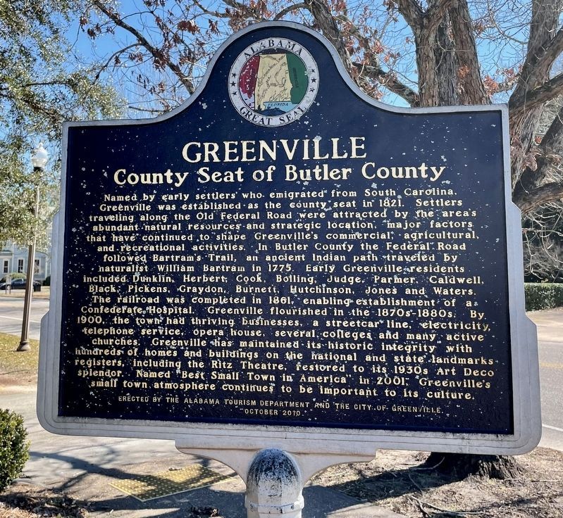
On Cushman Street at 4th Avenue on Cushman Street.
In the winter of 1904, the first Fairbanks Public School was opened. Ten students finished the spring term. In the fall of 1905, the school enrolled 50 students. The next year, 150 students attended.
Construction of a much-needed new school on the . . . — — Map (db m219204) HM
On Second Avenue, on the right when traveling east.
Construction of the Lacey Street Theater began in 1939, and this Art Deco style building opened in 1940. Austin E. “Cap” Lathrop, Fairbanks businessman and financier, was its owner. The Lacey Street Theater, with its distinguished neon . . . — — Map (db m58989) HM
On West Grand Canyon / West Route 66 at South 3rd Steet, on the left when traveling east on West Grand Canyon / West Route 66.
The wood framed 1894 Polson Bros. General Store burned down in the 1901 fire and was replaced by this brick building in 1907. The Babbitt and Polson families were pioneer merchants in the area. In 1930 the building was stuccoed to create the only . . . — — Map (db m33384) HM
On North Third Street at Pine Street, on the right when traveling south on North Third Street.
This building has been placed on
The National Register
of Historic Places
By the United States Department of the Interior.
A.T.&T. Building
Built 1930
A good example of Spanish Colonial Revival style with Federal Modern . . . — — Map (db m29395) HM
On West Congress Street, on the right when traveling west.
The Fox Tucson Theatre, the country's only southwestern art deco movie palace, was designed by California architect Eugene Durfee. Construction began in 1929 for the Tower Theatre, the crown jewel of the Diamos Brothers Southern Arizona Movie . . . — — Map (db m83033) HM
Coles Bashford arrived in Prescott in 1864 and was the first President of the Territorial Legislature. In 1874, Coles, his brother Levi, and son William formed a partnership with Robert Burmister. The Bashford-Burmister Company became one of the . . . — — Map (db m18806) HM
On Gurley Street (Arizona Route 89) at Washington Street., on the right on Gurley Street.
Since 1908, the area of Prescott now known as Ken Lindley Field has been used as a public park and ballfield. The land was deeded to the City of Prescott by Charles T. and Ada M. Joslin in 1922. As Mrs. Joslin requested, the City later . . . — — Map (db m21161) HM
On East 1st Street east of South Main Street, on the right when traveling west.
The building is an example of Moderne/Art Deco Style. It served as headquarters for Hollywood stars throughout the 1930 and 40's and was the center of Yuma's social life until 1960.
Dedicated December 1999, by the City of Yuma
for the . . . — — Map (db m29006) HM
On West Rush Avenue west of North Main Street, on the right when traveling west.
It was originally operated as a silent movie theater located on the West side of the square and owned by DE & Lulu Fitton. In 1929 JW Bass built a state of the art theater for talkies, leasing it back to the Fittons as the "New" Lyric. A mix of . . . — — Map (db m141840) HM
The present masonry Lamar Bathhouse, completed in 1923, has a symmetrical, California style of architecture. The large lobby contains nostalgic murals of historic landscapes, and country scenes.
Art Deco stairs, signs, and lights decorated the . . . — — Map (db m61777) HM
On West Hale Avenue, on the right when traveling east.
Thomas J. Florida established the Florida Brothers Company in 1926, supplying farm and home loans to families along the Cotton Highway. Mr. Florida built this Art Deco-influenced structure in 1935, featuring Indiana limestone. The building . . . — — Map (db m36612) HM
On Martin Luther King Jr Way at Allston Way on Martin Luther King Jr Way.
1939-1940
City of Berkeley Landmark
designated in 1982
These buildings are fine examples of the Art Deco style in the Bay Area. They were designed as an ensemble with the adjacent Berkeley High School Community Theater. Bas-reliefs and . . . — — Map (db m54218) HM
James W. Plachek, Architect, 1930
Addition, Ripley/BOORA Architects, 1999
Listed on the National Register of Historic Places
Berkeley’s first free public library system was established in 1895, with branches in west and south Berkeley. The . . . — — Map (db m52364) HM
On Milvia Street south of Center Street, on the right when traveling south.
City of Berkeley Landmark
designated 1985
The Farm Credit Administration built this structure to house federal agricultural banking and financial agencies, including one of the 12 Federal Land Banks that assisted Depression-era farmers. Features . . . — — Map (db m54258) HM
On Shattuck Avenue south of University Avenue, on the right when traveling south.
James W. Plachek, Architect 1917
Jim Novesel: The Bay Architects 1994
This small commercial building was built for William Heywood, son of Berkeley pioneer Zimri Brewer Heywood. The upstairs was used as the architectural offices of James W. . . . — — Map (db m52382) HM
On Durant Avenue at Fulton Street, on the right when traveling east on Durant Avenue.
City of Berkeley Landmark
designated in 1983
This Zig-Zag Moderne building, designed for the sale and servicing of Buick automobiles, captures the glamour, rising affluence, and sophistication of the post-World War I era. Charles Howard, who . . . — — Map (db m54334) HM
On Broadway at 21st Street, on the left on Broadway.
This is a superior rendering of the "Art Deco" or "Moderne" style of movie palace built during the rise of the motion picture industry. The Paramount, which opened on December 16, 1931, is the most ambitious theatre design of architect Timothy L. . . . — — Map (db m100560) HM
On Third Street at Alice Street, on the left when traveling north on Third Street. Reported permanently removed.
A tiny wholesale grocery firm was the first occupant of this warehouse built on speculation
for developers Hyman Davis and M. Parker. Founded in San Francisco in 1896 by Samuel Sussman, and
Gustav and Samuel I. Wormser, Sussman Wormser & Company . . . — — Map (db m145505) HM
On Fourth Street at Harrison Street on Fourth Street. Reported permanently removed.
The Oakland Portal's elaborate Beaux Arts façade conceals eight massive fans that draw in
fresh air and expel foul air to prevent carbon monoxide buildup in the George A. Posey Tube, an underwater automobile tunnel that runs under Harrison Street . . . — — Map (db m145508) HM
On Third Street at Harrison Street, on the left when traveling north on Third Street. Reported permanently removed.
In 1985, this warehouse was renamed "The Egghouse” after the building's first use as an
egg distribution center for Poultry Producers of Central California. Poultry Producers originated the
Nulaid® brand name, a brand employed today to market egg . . . — — Map (db m145511) HM
Near Summit Street near Court Street, on the right when traveling north.
Voters on July 17, 1854, selected Jackson as the county seat of the new County of Amador, born that June 14 after a spirited election. Fulfilling their promise, the Jackson town trustees, at no county expense, financed construction of the first . . . — — Map (db m27910) HM
On San Pablo Avenue at Central Avenue, on the right when traveling north on San Pablo Avenue.
The Cerrito Theater opened Christmas Day, 1937. Architect William B. Davis included Art Deco elements and fanciful murals in the theater. The theater closed in 1966 and was restored forty years later by the El Cerrito Redevelopment Agency. — — Map (db m94120) HM
On Ferry Street at Ward Street, on the left when traveling north on Ferry Street.
Designed Art Deco style
by the
Reid Brothers
Architects/San Francisco
Built by John McNamera
1922
Premier opening
July 2, 1926
Closed due to fire 1931
Reopened 1932
Closed 1961
Purchased by Contra Costa County 1998
Presently . . . — — Map (db m17208) HM
On Moraga Way at Bryant Way, on the left on Moraga Way.
The Orinda Theatre
opened its doors in 1941
and is the city's most
prominent visual
landmark with its
signature dorsal fin
marquee. It is a
textbook example of
Streamlined Moderne
Architecture, a late type
of Art Deco design
inspired by . . . — — Map (db m154890) HM
On Railroad Avenue near East 3rd Street, on the right when traveling north.
Since opening its doors on May 4, 1920, this theatre has been a cornerstone to the New York Landing Historic District in Old Town Pittsburg. Like many Bay Area theaters of the 1920's, the California Theatre was designed by A.W. Cornelius in a . . . — — Map (db m146532) HM
S.H. Kress & Co. was the trading name of a national chain of "five and dime" retail department stores operating from 1896 to 1981. Opening in 1931, this three-story reinforced steel and masonry building was designed by New York City-based architect . . . — — Map (db m115124) HM
On 20th Street at H Street, on the right when traveling west on 20th Street.
The Fox Theater was designed by Los Angeles-based motion picture theater architect S. Charles Lee (1899-1990), built by Beller Construction, and supervised by local architect Charles H. Biggar (1882-1946). The three-story Spanish Colonial Revival . . . — — Map (db m115126) HM
On Green Street south of E Street, on the left when traveling south.
Built in 1931 in the Art Deco style, this building originally housed the Kern County Library and was later given to the City. The Tehachapi Heritage League relocated the Museum to this site in 1982 through a long-term partnership with the City of . . . — — Map (db m52829) HM
On Air Way, 0.2 miles south of Sonora Avenue, on the right when traveling south.
Grand Central Air Terminal is an intact example of an early airport
passenger terminal and serves as a physical record of pivotal events that helped shape the development of air travel and the aviation industry in Southern California.
The air . . . — — Map (db m137664) HM
On Alamitos Avenue, on the right when traveling north.
This venue was built in 1929 as a multi purpose auditorium. In 1935 it opened as the Dunbar Skating Rink and served this function for many years. In 2001, after a period of vacancy, the Robert Gumbiner Foundation, through an adaptive reuse program, . . . — — Map (db m72710) HM
On Linden Avenue, on the right when traveling north.
In March 2008, during a routine roof replacement on the Lafayette building's 11th floor patio, workers uncovered the 8 by 8 foot tile mural of a kneeling camel in front of the Pyramids of Giza. The vintage 1920's mural lay beneath two tons of . . . — — Map (db m72686) HM
On Linden Avenue, on the right when traveling north.
A complex of three historic buildings in different architectural styles. The Campbell Apartments at 130 Linden were designed by Parker O. Wright and Francis Gentry in a Spanish Baroque style in 1928. The Lafayette Hotel was a premier art deco hotel . . . — — Map (db m72454) HM
On Flower Street south of 5th Street, on the right when traveling south.
Tall, Dark And Prosperous
City National Plaza’s sleek, gleaming, granite-sheathed, 52-story twin towers are monuments to Los Angeles’ long history and oil
capital, and to the banking money that followed the black gold.
For more . . . — — Map (db m164082) HM
On 5th Street at Grand Avenue, on the right when traveling west on 5th Street.
"Power Personified In Stone…"
In downtown Los Angeles, there's
power — the kind wielded
from boardrooms and corner
offices — and there's power
— the kind that illuminates
lightbulbs and warms houses.
Two buildings — one . . . — — Map (db m231324) HM
On South Olive Street south of 6th Street, on the right when traveling south.
Paris Exposition
Like the jewel-box that it is, the Oviatt Building husbands its treasures within its walls… yet even casual passerby can get a hint of the gorgeousness inside, from just a glimpse of the nymph-crowned gates, of the overhead . . . — — Map (db m164333) HM
On Stadium Way west of California Route 110, on the right when traveling west.
Designed as the largest enclosed structure without columns in the world by noted California architects Robert Clements & Associates, this Art Deco building, constructed between 1938 and 1941 by the WPA, is the largest and second-oldest Navy Reserve . . . — — Map (db m147662) HM
On Riverside Drive north of Zoo Drive, on the right when traveling north.
A Dangerous Bottleneck
Prior to the Riverside Drive Bridge that you see today, there was once a wooden structure crossing the Los Angeles River in its place. However, this old wooden bridge was inadequate to serve the increasing . . . — — Map (db m223397) HM
On Riverside Drive north of Zoo Drive, on the right when traveling north.
Originally known as the Victory Boulevard bridge, the Riverside Drive bridge was constructed in 1938 to improve a bottleneck caused by an earlier wooden bridge. It was partially funded by President Franklin D. Roosevelt’s Works Progress . . . — — Map (db m129133) HM
On Highland Avenue south of Hollywood Boulevard, on the left when traveling south.
Max Factor, a Russian immigrant, pioneered screen
make up for which he received a special Academy
Award in 1929. He opened the Max Factor Hollywood
Makeup Studio in 1928, where he taught Hollywood
stars such as Lana Turner, Rita Hayworth, . . . — — Map (db m167871) HM
On Valley Oak Drive north of Verde Oak Drive, on the right when traveling north.
An Art Deco masterpiece reflecting a great era of Hollywood cinema.
Declared Historic Cultural Monument No.130 by the Cultural Heritage Board, Municipal Arts Department, City of Los Angeles. — — Map (db m169769) HM
On Wilshire Boulevard at Westmoreland Avenue, on the right when traveling east on Wilshire Boulevard.
Los Angeles in the Art Deco Age
Los Angeles leapt into the modern era on September 26, 1929. At nine o'clock that morning, the doors of Bullock's Wilshire opened to gasps of amazement. Here was the first department store in the country to be . . . — — Map (db m120962) HM
On Lankershim Boulevard at Weddington Street, on the right when traveling south on Lankershim Boulevard.
Hollywood Comes North
The community of North Hollywood was still a year away from being given that official name when a jewel box of a theatre called the "El Portal" opened in October of 1926.
The world was still a year away . . . — — Map (db m167283) HM
Opened as the Warner Brothers Theatre on January 20, 1931, it was designed by architect B. Marcus Priteca and interior designer Anthony B. Heinsbergen and was the first sound-equipped theater in the South Bay. Jack Warner called it "The castle of . . . — — Map (db m81922) HM
On Main Street at Second Street, on the right when traveling north on Main Street.
Built in 1893, the Oberon was the hub of activity in downtown Napa. Patrons could buy a cigar, get a shave and a haircut for two bits, or relax with a cold beer while playing a leisurely game of pool or cards. Many a shoe was shined here. In 1932 . . . — — Map (db m69324) HM
On North Palm Canyon Drive (Business California Route 111) south of East Tahquitz Canyon Way, on the right when traveling south.
The Oasis Hotel, constructed 1923-25, contained approximately 20 units and included the Tower Building, the only three story hotel building in Palms Springs for many years.
The 40 foot tower, with its pyramidal roof, provided access to the . . . — — Map (db m52742) HM
On Arnold Avenue at McClellan Mall, on the left when traveling north on Arnold Avenue.
Headquarters has long been the heart of the installation. In the 1940s, civilian visitors and military dignitaries arrived at the Sacramento Air Depot through Gate 2, which was located at the end of the landscaped mall you see behind you. This . . . — — Map (db m57285) HM
Identifying A Need
By the early 1930’s, Americans were moving away from trains and ships and turning to automobiles as their mode of transporation. As a result, traffic on roadways increased dramatically. In Sacramento, M Street (now . . . — — Map (db m16490) HM
On G Street, 0.2 miles east of Euclid Avenue, on the left when traveling east.
Central School was founded in 1887 and was Ontario’s first public
school. This is the third school building on this site and was
designed by Harry L. Pierce. It was built in 1934 as a WPA project.
It is one of the finest examples of Art Deco . . . — — Map (db m161078) HM
Near Convention Way at Marina Park Way, on the right when traveling west.
San Diego’s Cultural Oasis
Located just minutes away from downtown San Diego, Balboa Park provides an enriching experience for more than 14 million visitors from near and far each year. Referred to as “the Smithsonian of the . . . — — Map (db m73907) HM
On Duboce Avenue near Market Street, on the right when traveling west.
In 1936 almost half of Mint Hill was removed to create a flat base for the Mint.
In 1947 Duboce Avenue east of the Sunset Tunnel was crowded with automobiles as shoppers thronged to the farmers’ market.
The area near Market and Church . . . — — Map (db m128827) HM
On Duboce Avenue near Market Street, on the right when traveling west.
During the first half of the 20th century, electric streetcars reigned.
Hills were soon surmounted by the cable car.
The Industrial Age created the need for efficient urban transportation, which came first in the form of horse-drawn . . . — — Map (db m72657) HM
On Portola Road, on the right when traveling north.
Built in 1912 this country church was the first executed design of noted architect, Timothy L. Pflueger, who had just begun work for James Miller. An awareness of the Spanish California Missions inspired the style, which contrasts with the large . . . — — Map (db m18463) HM
On West Santa Clara Street at Notre Dame Avenue on West Santa Clara Street.
Completed in 1931, as a civic improvement project during the Great Depression, the Hotel De Anza was named in honor of the Spanish explorer Juan Bautista de Anza. Business and civic leaders established the San Jose Community Hotel Association which . . . — — Map (db m52659) HM
On Pacific Avenue near Cathcart Street, on the right when traveling south.
1856 Architects Row
Farms and orchards surrounded the site’s original buildings. These were the 1856 home and office of architect Thomas Beck and 1861 home and office of architects John Morrow and John Williams north of Beck’s. Churches Morrow . . . — — Map (db m62503) HM
On Market Street, on the right when traveling west.
Date Opened: August 9, 1935
Owner Operator: T & D Jr. Enterprises
Architect: J. Lloyd Conrich / San Francisco, CA
General Contractor: Sath Brothers / San Francisco, CA
Date Reopened : August 14, 2002
Owner Operator: Southern Oregon . . . — — Map (db m70330) HM
On Main Street near Tulare Street, on the right when traveling south.
The 700 seat Art Deco Style theatre was built in 1940 by the Stephens-Hamm families. Opened August 1 featuring “The Boys from Syracuse”. Locally owned as operated as a movie theatre until 1984, when it became the cultural center of the West Side. — — Map (db m208397) HM
The fountain was erected in 1936 by the Boulder Lions Club. Its smooth terra cotta cladding and strong vertical lines complement the 1933 Art Deco Style courthouse. The courthouse and fountain were designed by local architect Glen H. Huntington. . . . — — Map (db m87600) HM
On Wazee Street at 19th Street, on the right when traveling north on Wazee Street.
Built in 1930-31 as a multi-tenant warehouse, 1863 Wazee Street is representative of the final building period in Lower Downtown until the boom of the 1980's. Architect Montana Fallis used the modernistic style to establish this building as Denver's . . . — — Map (db m97348) HM
On 17th Street near Wazee Street, on the right when traveling south.
The Oxford Hotel, built in 1891, is Denver's Oldest Hotel. Bankrolled by Brewer Adolph Zang and his partners Philip Feldhauser and William Mygatt, the hotel was designed by Denver's greatest 19th century architect, Frank E. Edbrooke. Through the . . . — — Map (db m6674) HM
On South 4th Street at Colorado Avenue, on the right when traveling south on South 4th Street.
An early stagecoach stop, The Grand Hotel, welcomed visitors with a tin-faced, two-story building, surrounded by shade trees, wooden sidewalks, and spacious lobby. In 1904 the building was purchased from William and Allie Neff and Anna Scott by . . . — — Map (db m120050) HM
On East Main Street (U.S. 160) west of North Ash Street, on the right when traveling west.
This building was originally constructed in 1900.
The most notable occupant at this site was the Belmont Bar, a rough and raucous local drinking establishment during the 1950s and '60s.
The 1930s storefront is of an "art deco” character . . . — — Map (db m153363) HM
On Governor Street at Main Street (Connecticut Route 35), on the right when traveling west on Governor Street.
Hiram K. Scott set up the town's first variety and drug store in 1853. Scott was an influential businessman, serving as postmaster, town clerk, probate judge and a druggist for 50 years. He sold his store to Harvey Bissell in the summer of . . . — — Map (db m31587) HM
On 11th Street Northeast south of C Street Northeast, on the left when traveling south.
Designed 1916
in Moorish Revival Style
Architect
William S. Plager
(1860-1946)
Photo: circa 1926
Goode Collection
Library of Congress
Redesigned 1941
in Art Deco Style
Architect
Mihran Mesrobian . . . — — Map (db m134068) HM
On Nannie Helen Burroughs Avenue Northeast at Division Avenue Northeast, on the left when traveling north on Nannie Helen Burroughs Avenue Northeast. Reported missing.
The Two-Story Art Deco Style Building on your left was once the Strand Theater. Abe Lichtman, a Jewish businessman whose movie theaters catered to black patrons, opened the Strand in 1918. Lichtman also operated the Lincoln and Howard . . . — — Map (db m130777) HM
On Georgia Avenue Northwest (U.S. 29) at Missouri Avenue Northwest, on the right when traveling south on Georgia Avenue Northwest.
The Grand, Neo-classical Revival style building that you see across Georgia Avenue north of Missouri opened in 1925 as the Bank of Brightwood, thanks to efforts of the Brightwood Citizens Association. Designed by Treasury Department architect . . . — — Map (db m72818) HM
On Georgia Avenue Northwest (U.S. 29) at Peabody Street Northwest, on the left when traveling north on Georgia Avenue Northwest.
The Large Structure across Georgia Avenue opened in 1909 as a "car barn" for the Brightwood Railway. The facility could service more than 40 streetcars at once, and often did so late at night. As a young boy in the 1950s, Thomas Reardon . . . — — Map (db m72831) HM
On Sheridan Street Northwest east of 14th Street Northwest, on the right when traveling west.
We have Harry Wardman to thank for the rich variety of Sheridan Street rowhouses. Wardman, considered Washington's most prolific developer, built hundreds of offices, apartments, hotels, and comfortable rowhouses from 1899 to 1939. When he . . . — — Map (db m72823) HM
On Louisiana Avenue Northwest west of North Capitol Street Northwest, on the right when traveling west.
On March 3, 1869, President Andrew Johnson signed the Congressional Act chartering The Masonic Mutual Relief Association that became Acacia Life Insurance Company
Built as its headquarters and occupied by Acacia until 1997, the building . . . — — Map (db m186817) HM
On Connecticut Avenue Northwest south of Porter Street Northwest, on the right when traveling south.
1920-1930:
Apartments, Shops and Cars
“Connecticut Avenue is the principal approach to what is undoubtedly Washington's greatest suburban buying power” — The Washington Post, December 7, 1930
Early development . . . — — Map (db m155387) HM
On 17th Street Northwest at S Street Northwest, on the right when traveling north on 17th Street Northwest.
At 1740 New Hampshire Ave. (above) stands the Dove House (1898). The private home has been converted into a 12-unit condominium, including a single unit with a loft in the former high-ceilinged ballroom.
The Art Deco Carlyle Suites at . . . — — Map (db m128038) HM
On Constitution Avenue Northwest (U.S. 1/50) at 10th Street Northwest, on the right when traveling west on Constitution Avenue Northwest.
The roots of America's top law enforcement agency, the Department of Justice, reach back to 1789. That year the first Congress created the Office of the Attorney General to prosecute lawsuits in the Supreme Court and advise the President and . . . — — Map (db m57214) HM
On Pennsylvania Avenue Northwest at 10th Street Northwest, on the right when traveling east on Pennsylvania Avenue Northwest.
The Federal Bureau of Investigation is headquartered across Pennsylvania Avenue from this spot. Thanks to popular media, it may be one of the better-known government agencies. Since the 1930s Hollywood has found great stories among the . . . — — Map (db m57218) HM
On Pennsylvania Avenue Northwest at 6th Street Northwest, on the right when traveling east on Pennsylvania Avenue Northwest.
This is the Federal Trade Commission Building, home of the agency that defends the public against unfair methods of competition and unfair or deceptive acts or practices. One of the older independent Federal agencies, the FTC was created in . . . — — Map (db m59219) HM
On 4th Street Northwest at Indiana Avenue Northwest, on the right when traveling south on 4th Street Northwest.
The Great Depression (1929-1941) meant economic catastrophe for millions of Americans, but in Washington it meant a building boom as the Federal Government staffed up to the end the economic crisis. In 1931 alone Congress approved new . . . — — Map (db m61823) HM
On D Street Northwest west of 5th Street Northwest.
DC’s Art Deco/Art Moderne Recorder of Deeds Building (1941) houses city land records. Many notable African Americans have served as recorders of deeds since President Garfield appointed Frederick Douglass to the post in 1881. These include Branche . . . — — Map (db m29657) HM
On Wisconsin Avenue Northwest at Warren Street Northwest, on the right when traveling west on Wisconsin Avenue Northwest.
Security and style came to Tenleytown in 1900, when Engine House No. 20 opened across from Wisconsin Avenue. No longer would fire fighters have to come all the way from Georgetown to extinguish blazes in Tenleytown's wood-frame houses. Opened . . . — — Map (db m147297) HM
On Moncrief Road near Edgewood Avenue, on the right when traveling west.
Pioneer Abraham Lincoln Lewis (1865-1947) and others founded Florida’s oldest African-American insurance company, Afro-American Life in 1901, which spread throughout the South as far as Texas. In 1926, A.L. Lewis opened Lincoln Golf and Country Club . . . — — Map (db m58382) HM
On Madison Street near North Marion Street, on the left when traveling east.
St. Andrew's Episcopal Church was established in Tampa in 1871. Its first service was held in the hospital building at Fort Brooke. A wooden church was erected in 1883 on the city block bounded by Marion, Twiggs, Morgan, and Madison Streets, which . . . — — Map (db m26906) HM
On Pan American Drive at South Bayshore Drive, in the median on Pan American Drive.
Known as the “Air Gateway between the Americas”, the Pan American Seaplane Base and Terminal Building is significant in the history of modern air transportation and is an outstanding example of air terminal design. In 1929, Pan American Airways . . . — — Map (db m150780) HM
On North Krome Avenue (State Road 997) at West Mowry Drive, on the right when traveling south on North Krome Avenue.
The Seminole Theater has been designated a City of Homestead Historic Landmark
This building, originally constructed in 1921, was subsequently restored in 1940 with an Art Deco facade following a devastating fire. The theatre was mainly used as . . . — — Map (db m73365) HM
On Northwest North River Drive at Northwest 4th Street, on the left when traveling north on Northwest North River Drive.
This land on the north side of the Miami River was developed as a residential area soon after the City Park opened in 1909. Along NW 3rd and NW 4th Streets a mixture of single-family and multi-family structures were built that were made of strong . . . — — Map (db m78195) HM
On Biscayne Boulevard (U.S. 1) at Northeast 13th Street, on the left when traveling north on Biscayne Boulevard.
This seven-story octagonal tower was built in 1929 as an entrance to the Sears Roebuck and Company department store, which was designed by the architectural firm Nimmons, Carr and Wright. It was the focal point of the first Art Deco style . . . — — Map (db m63894) HM
On Ocean Drive south of 14th Street, on the right when traveling south.
This plaque, unveiled in February 2018, commemorates the completion of the second major rehabilitation of the Cardozo Hotel. The first Art Deco jewel, in which Mrs Capitman initiated her passionate battle to finally preserve the "Old Miami Beach" . . . — — Map (db m134651) HM
On Ocean Drive north of 13th Street, on the right when traveling north.
Writer Artist Preservationist Founder of the Miami Design Preservation League 1976 She led the crusade to establish the Miami Beach Art Deco District Sculpture by her mother Myrtle Bachrach Baer c. 1940 — — Map (db m134654) HM
On Ocean Drive at 10th Street, on the right when traveling north on Ocean Drive.
This building is home to the Miami Design Preservation League, founded by Barbara Baer Capitman in 1976. On May 14, 1979 under her leadership, the Miami Beach Architectural District (Art Deco District) became the first urban 20th century historic . . . — — Map (db m134707) HM
On Collins Avenue north of 14th Street, on the left when traveling north.
The Lummus Brothers of Ocean Beach Realty Co. platted an addition to the Ocean Beach Subdivision in 1913. The area was sparsely settled with small seasonal rooming houses and 2 story homes. In 1926 the NW corner of Collins Avenue and 14th street . . . — — Map (db m134714) HM
On Ocean Drive at 10th Street, on the right when traveling north on Ocean Drive.
Affectionately known as the "Art Deco" District, the Miami Beach Architectural District embodies the design continuum of the City from its early development period in the 1910s to the construction boom following World War II. This district was . . . — — Map (db m134709) HM
On 2nd Avenue Northeast east of Bayshore Drive Northeast, on the right when traveling east.
(Front plaque)From this site The St. Petersburg-Tampa Airboat Line The World's First Scheduled Airline Began regular flights between St. Petersburg and Tampa, January 1, 1914. ⋆ This plaque and site dedicated December 4, . . . — — Map (db m50437) HM
Near Benjamin Franklin Drive at Grant Drive, on the left when traveling north.
Lido Beach Casino
For nearly thirty years the Lido Beach Casino attracted residents and tourist for pool and gulf swimming, dining, dancing, shopping, and enjoying the beach. Activities such as swim meets, beauty pageants, and school and . . . — — Map (db m146244) HM
On Bull Street near E. Hull Street, on the right when traveling north.
This theatre is the oldest in active use
in the United States.
Built by the eminent architect Jay
Opened Dec. 4, 1818 with the Comedy
"Soldier's Daughter"
and a Farce
"Raising The Wind"
Within these walls have played
the greatest . . . — — Map (db m15135) HM
On 1st Avenue Southeast (Georgia Route 37) at 1st Street Southeast (Business U.S. 319), on the left when traveling east on 1st Avenue Southeast.
1908 Original 1936 New Louis Friedlander came to the Colquitt County area about 1907, when he was only 16 years old. He began his Merchant career as a peddler, with a pack on his back. After a year of walking the area, he . . . — — Map (db m195861) HM
On Newcastle Street (U.S. 25) north of Gloucester Street, on the right when traveling north.
Machen Square originally called “Machen Place,” is the northernmost of the original colonial squares along Newcastle Street. For the century of the city’s existence, there was little development on either side of Machen Square. In the . . . — — Map (db m155733) HM
On West Washington Street at North 10th Street, on the right when traveling west on West Washington Street.
In 1903, Boise High School opened to students in an elaborate, red brick Victorian building. As the city grew, more space was needed and a new building was designed by the firm of Tourtellotte and Hummel. In order to minimize disruption to students, . . . — — Map (db m111328) HM
345 entries matched your criteria. The first 100 are listed above. Next 100 ⊳