On Ritchie Avenue east of Main Street, on the right when traveling east.
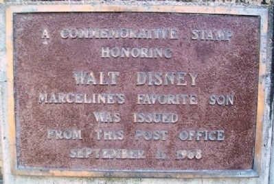
After Walt Disney's death in December of 1966, the citizens of Marceline lobbied the United States Postal Department to issue a commemorative stamp to his honor. The postal department agreed to issue the stamp. After the issuance of the stamp was . . . — — Map (db m67165) HM
On South Main Street north of Madison Street, on the left when traveling north.
"The first term of the Court of Common Pleas in and for the District of St. Charles was held on the first Tuesday in January, 1805, in the house of Dr. Antoine Reynal on the site of the present courthouse." The "present" courthouse of . . . — — Map (db m124826) HM
On South Main Street at Madison Street, on the right when traveling west on South Main Street.
An earlier two-story structure, known as the Old Benne Building built by Joseph C. Easton circa 1840, was replaced by this building in 1882. The new Second Empire /Italianate building with its parade balcony and bracketed cornices and pediments . . . — — Map (db m124825) HM
On Grand Drive, 0.1 miles east of Lagoon Drive, on the right when traveling west.
In 1920, city officials used park land to build a runway for the new St. Louis to Chicago airmail service. Although the service operated for less than one year, the area is still known as Aviation Field. — — Map (db m139726) HM
Near Barrett Station Road east of Old Dougherty Ferry Road, on the right when traveling east.
Owney, the 'unofficial' mascot of the United States Postal Service, was the first dog to travel around the world. During the late 1800's Owney traveled with mail carriers first on mail trucks, then steamships. While traveling around the world, . . . — — Map (db m132896) HM
On West Main Street (U.S. 87) near 6th Avenue South, on the left when traveling west.
In March of 1914, four hundred local business owners protested locating Lewistown’s new post office on this site, claiming that the call for bids was not properly advertised. Most favored housing the post office in the Masonic Temple building. . . . — — Map (db m143414) HM
On 1st Avenue West near 8th Street West, on the right when traveling south.
Built by William F. Eckelberry around 1903, this four-square residence features a full basement, a front gabled dormer, a full-width front porch, and a leaded-glass bay window in the dining room. Remodeling efforts in 1910 reduced the recessed . . . — — Map (db m160963) HM
On Hebgen Lake Road (U.S. 287) 3.5 miles west of U.S. 191, on the right when traveling west.
By 1898 a 10-foot wide road was built through the Gallatin Canyon to Taylors Fork and the park line. In 1911 a crude, narrow wagon road went to "Yellowstone" (West Yellowstone), 90 miles from the county seat at Bozeman. In 1926, the road was . . . — — Map (db m113833) HM
On 3rd Avenue at 3rd Street, on the right on 3rd Avenue.
Red brick, finely crafted stonework, and a colonnade reminiscent of a Greek temple brought an imposing federal symbol to Havre in the 1930s. Securing state and federal funds for this post office was an expression of optimism during economic . . . — — Map (db m142645) HM
On Main Street (Business Interstate 90) south of Milwaukee Avenue, on the right when traveling south.
The first post office in Deer Lodge was established on May 21, 1866. It was one of the earliest post offices in Montana. Mail service to the early settlers of the Deer Lodge Valley was very expensive and very slow. Letters and parcels were either . . . — — Map (db m128356) HM
On West Main Street (State Highway 531), on the right when traveling west.
When construction began on Hamilton’s post office in August 1940, the worst of the Depression was over. Nevertheless, the building is a legacy of the New Deal, when the number of federal construction projects soared to put people to work. Montana . . . — — Map (db m123552) HM
On 2nd Street (U.S. 30) at Locust Street, on the left when traveling west on 2nd Street.
Originally designed as a U.S. Post Office and Court House, the Grand Island Federal Building opened on November 26, 1910. It was designed by James Knox Taylor and cost $108,000. The 1935 west-wing addition was designed by local architect, Charles . . . — — Map (db m53250) HM
On O Street (U.S. 34) west of 10th Street, on the right when traveling west.
In 1874 construction began on Lincoln's first U.S. Post Office and Courthouse on a block originally intended as a market square. The building was completed by 1879 at a cost of about. $200,000. Alfred B. Mullet, supervising architect of the U.S. . . . — — Map (db m66884) HM
On Courthouse Avenue south of 13th Street, on the right when traveling south.
During the 1930s, President Franklin D. Roosevelt's New Deal created government programs to counter the effects of the Great Depression. Hundreds of post offices were built and the U.S. Treasury commissioned art for many of them. Twelve Nebraska . . . — — Map (db m78462) HM
The original site of Beaver Crossing was located about three miles to the northwest. Here a trail from Nebraska City to Fort Kearny crossed Beaver Creek. John Leonard and Daniel Millspaugh were the first settlers in this area in 1862. Roland Reed . . . — — Map (db m76748) HM
On North Carson Street at East Telegraph Street, on the right when traveling north on North Carson Street.
This imposing public structure, the former United States Post Office and Courthouse, represents the first federal office building constructed in the State of Nevada.
Construction began in late 1888 and was completed in 1891 at a cost of $138, . . . — — Map (db m101827) HM
On North Maine Street (U.S. 95) just south of East A Street, on the right when traveling north.
In 1929, this building was deemed a magnificent improvement to the city. Built to U.S. Postal Service standards, this brick structure features massive single doors on either end of a vestibule that protects the inside from the elements. Carved . . . — — Map (db m142625) HM
On Las Vegas Boulevard (Nevada Route 161) 0.1 miles east of Interstate 15, on the right when traveling east.
Founded in 1904 as Goodsprings Junction, a station on the San Pedro, Los Angeles, and Salt Lake Railroad, Jean received its current name in 1905 when the post office was opened. It was named in honor of Jean Fayle, the wife of George Fayle who had . . . — — Map (db m129575) HM
Near East Washington Avenue near Las Vegas Boulevard North.
John Steele, one of the original L. D. S. missionaries, secured a mail grant for the Las Vegas Mission. The documents to establish the Post Office, and, appointing William Bringhurst Postmaster, were brought from Salt Lake City by Benjamin H Hulse, . . . — — Map (db m29294) HM
On East Stewart Avenue at North Third Street on East Stewart Avenue.
This property
has been placed on the
National Register
of Historic Places
by the United States
Department of the Interior
United States Post Office
and Courthouse
c.1933 — — Map (db m47746) HM
On April 6, 1926, Varney Air Lines pilot Leon Cuddeback, carrying one bag of mail, landed his tiny Curtis Swallow bi-plane at Elko, Nevada, completing the first scheduled air mail run in the United States.
The single engine, 90-horsepower . . . — — Map (db m1371) HM
On Idaho Street, on the right when traveling west.
Constructed on Sherman Creek in Huntington Valley, 60 miles south of Elko, by rancher Valentine Walther. It took Walther, family and friends seven years to complete and was finished in 1903. The house served as a home, post office, stage stop and . . . — — Map (db m1431) HM
On Gold Street, 15 miles south of U.S. 95, on the left when traveling south.
Known originally as Lime Point, this area was first settled about 1880. The early camp was abandoned by 1882. In March 1908, a silver strike brought a new camp into existence. Called Hornsilver, it flourished for about a year, boasting about 800 . . . — — Map (db m34251) HM
On Main Street at Pike Street, on the left when traveling west on Main Street.
The original Union Hotel was located across the street. It was rebuilt here in 1870 after a fire destroyed the old hotel. The former post office site originally housed the dining room and barber shop. The freestanding rock wall is the original . . . — — Map (db m89513) HM
On National Forest Development Road 26, 0.5 miles National Forest Development Road 28, on the left.
Formerly known as Six Mile Station, this stage stop and way station provided service between some of the smaller mining camps and Aurora and Bodie, CA during the late 1860's. The area became of greater importance with the arrival of the Carson . . . — — Map (db m37630) HM
On Main Street (U.S. 302) east of Maple Street, on the right when traveling west.
This marble-fronted edifice has been the town’s Post Office since February 14, 1935.
The mansion of Dr. William J. Beattie (1865-1913), a founder of Littleton Hospital, had occupied the site before the construction of this Georgian Revival . . . — — Map (db m116229) HM
On Industrial Avenue, on the right when traveling north.
The home of Gates Flying Circus. Teterboro built Fokker tri-motors flown by Richard E. Byrd over the North Pole (1926); South Pole (1929); Atlantic (1927); and by Amelia Earhart over Atlantic (1928). Clarence Chamberlin, Ruth Nichols, Floyd . . . — — Map (db m6863) HM
On Pascack Road at Woodcliff Avenue, on the right when traveling north on Pascack Road.
Frederick Wortendyke IV built this house between 1812 – 1825 to replace an older home near-by. It stands on land purchased in 1775 by his grandfather Frederick Jr. of Park Ridge. The family operated a general store on the opposite side of . . . — — Map (db m22252) HM
On E Main Street, on the right when traveling east.
Oldest portion built by Joshua Borton Circa 1800 Owners: Gilbert Page, General Store & PO. 3rd Postmaster 1813 – 1839 Ebenezer Roberts Late 1800. — — Map (db m35963) HM
Near Evesham Avenue West at East Atlantic Avenue, on the right when traveling west. Reported unreadable.
These were the last years of the Atlantic City Railroad. What began as an amazing accomplishment ended heroically some 124 years later and spanned a century and a quarter 1877 to 1001. Hundreds of passengers a week had been carried "express" at . . . — — Map (db m146747) HM
On River Street at Hudson Place, on the right when traveling north on River Street.
This site was once close to the geological edge of the Hudson River. This building, CIRCA 1889, close to major transportation was once Hoboken's largest commercial structure. Built as the Second National Bank, it housed a variety of uses, most . . . — — Map (db m6881) HM
On Little York - Mt. Pleasant Road (County Route 519) at Rick Road, on the right when traveling north on Little York - Mt. Pleasant Road.
This property, comprising the Mount Pleasant General Store and a smokehouse at the rear, is on the National and State Registers. The smokehouse was constructed in the early 1830's, and the store was erected around 1840. Both were built by the Warne . . . — — Map (db m37110) HM
On Water Street at Rockaway Road, on the right when traveling west on Water Street.
Established in 1880 by the Farley family, the Post stayed in the family for 100 years. It has served as Post Office, General Store and focal point for the Village of Mountainville. — — Map (db m16670) HM
The South Amboy Post Office was located here in 1912. From this post office the First Air Mail Delivery Flight in New Jersey was undertaken. This event was the brainchild of Assistant Postmaster Edwin Roddy, also a member of the South Amboy’s . . . — — Map (db m93915) HM
On S James Street, on the right when traveling west.
The original post office of Woodbridge, established July 31, 1792, was located at the Cross Keys Tavern on the northwest corner of Amboy Avenue and Main Street. The first postmaster appointed by Postmaster General Timothy Pickering was the . . . — — Map (db m19888) HM
United States Post Office
Woodbridge, New Jersey 07095
On November 15, 1969, after probably many more than seven documented relocations, the Post Office was relocated at the present site at 60 Main Street, with 9,650 sq. ft. enlarged space. . . . — — Map (db m125438) HM
On Stafford Avenue at Division Street, on the right when traveling east on Stafford Avenue.
A small pharmacy was built on this site in 1890 for Dr. John Lewis Lane, who had grown up in Tuckerton, graduated from Jefferson Medical college in Philadelphia, and then returned to the area to practice.
While still a pharmacy, the less . . . — — Map (db m209210) HM
Built 1937 by Sherman Construction, Passaic N.J. Designed by Louis A. Simons supervising architect for the Dept. of the Treasury 1933-1939. A cast stone portrait of Benjamin Franklin by artist Sterling Calder is in the lobby. An excellent of example . . . — — Map (db m94673) HM
Near Greenwood Lake Turnpike, on the right when traveling west.
The company store was a center of village life for over 160 years, containing not only a wide assortment of merchandise, but also the post office and company bookkeeper’s office. Purchases at the store were deducted from workers’ . . . — — Map (db m65910) HM
On Main Street at Blair Place, on the right when traveling west on Main Street.
Early history describes this building as a single structure, which when researched proves to not be entirely accurate. The structure is comprised of two separate entities joined together circa 1889. The first of these, the small rear two-story . . . — — Map (db m97737) HM
On Main Street near E. 4th Street, on the left when traveling north.
Roswell’s first general store and post office stood near this spot. The building was constructed by Van C. Smith in 1870 and hosted a somewhat famous postmaster, Ash Upton, who was a political player in the Lincoln County War and the ghost writer . . . — — Map (db m102896) HM
On State Road 152 at milepost 48.8, on the left when traveling west.
Built in 1879, this building has been a mercantile, pharmacy, grocery, post office and telephone exchange. Site No. 1304
A Registered Cultural Property State of New Mexico — — Map (db m38296) HM
On Salamanca-Sugartown Road (New York State Route 98) at Humphrey Road, on the right when traveling north on Salamanca-Sugartown Road.
Built ca 1856 at junction of Ellicottville-Great Valley Plank Road & road to Franklinville. Served as hotel, livery & post office — — Map (db m95789) HM
On Chestnut Ridge Road (New York State Route 277) at Powers Road, on the left when traveling south on Chestnut Ridge Road.
Established at John Green's Tavern, April 8, 1814 and discontinued April 13, 1820. Mail arrived at this post office 3 times weekly. Settlers traveled miles to receive their mail here. — — Map (db m80795) HM
Near Broadway near Park Row, on the left when traveling south. Reported permanently removed.
On this site stood the western wall of the Federal Post Office. Designed by Alfred B. Mullet – architect of the Old Executive Office Building in Washington, D.C. – the ornate building’s broad north façade faced City Hall, while its sides . . . — — Map (db m130086) HM
On Eighth Avenue north of West 31st Street, on the right when traveling north.
Front:
Hello…
I worked as a letter carrier here after serving in WWII. When I first started, the entire city had one postal zone. Mail volume grew over the next 20 years. To make sorting and delivering easier, the USPS created the Zone . . . — — Map (db m156623) HM
On Forest Parkway north of Jamaica Avenue, on the left when traveling north.
Art Moderne bldg of enameled panels & classical windows & doors. The WPA mural by Ben Shahn represents the Bill of Rights and is landmarked. — — Map (db m133643) HM
On Eatons Corners Road (County Route 147) at Bramans Corners Road (County Route 102), on the right when traveling north on Eatons Corners Road.
Site of post office & store established about 1820 by Lemuel Eaton and run for years. He brought the mail each Saturday on horseback from Amsterdam. — — Map (db m29760) HM
On State Street (New York State Route 68) north of Knox Street, on the left when traveling north.
In 1856, the City of Ogdensburg petitioned the U.S. Treasury Department to construct an imposing Federal building that would suitably reflect Ogdensburg's importance as northern New York's leading social and commercial center.
This structure . . . — — Map (db m75638) HM
On Vernon Valley Road, on the left when traveling south.
Site of first Larkfield Post Office – 1896 in Chester Smith’s Store. Moved across street in 1909. In 1910, it was re-named East Northport. In memory of Frank G. Becher — — Map (db m148823) HM
On Lake George Road (U.S. 9), on the right when traveling south.
A 19th century community with
the Halfway House, Brown's store
plank road tollgate, School #14,
sawmill, tannery, race track,
Post Office and 14 residences. — — Map (db m18468) HM
Near R Dean Coleman Road, 1 mile north of Friendship Patterson Mill Road.
During the 1870's and 80's, this building served as a community post office. The building has been restored and displays "pigeon holes" which are compartments used to sort the mail.
The building on the right is a smoke house. It dates back to . . . — — Map (db m222794) HM
On South Main Street, on the left when traveling south.
The road from New England to Charleston, over which mail was first carried regularly in North Carolina, 1738-39, passed near this spot. — — Map (db m65358) HM
On U.S. 17 near the South Carolina line, on the right when traveling north.
The road from New England to Charleston, over which mail was first carried regularly in North Carolina, 1738–39, passed near this spot. — — Map (db m6317) HM
On Broad Street (State Highway 57) at Liberty Street, on the right when traveling west on Broad Street.
First built as Watkins Dry Goods Store where clothing could be purchased. There was also a school room and you could buy books. Bought by Walter Lea Thomas in 1910 and operated by him and his sons as a general merchandise store and a post office . . . — — Map (db m220873) HM
On Broad Street (Highway 57) east of Liberty Street, on the right when traveling west.
Built by Dabney Cosby, construction protégé of Thomas Jefferson. Served as a banking house and staff residence for 49 years, later Milton Post Office for 51 years, and thereafter a private resident. Listed in the National Register of Historic Places . . . — — Map (db m171775) HM
On Virginia Road (State Highway 32) at Badham Road, on the left when traveling south on Virginia Road.
The road from New England to Charleston, over which mail was first carried regularly in North Carolina, 1738-39, passed near this spot. — — Map (db m79793) HM
On South Main Street (State Highway 150) at Quinn Circle, on the right when traveling north on South Main Street.
Originally constructed as a General Store, this building served as a U. S. Post Office beginning in the 1930's and has been used for a variety of purposes since then. According to local residents, W. J. Cash wrote a portion of The Mind of the . . . — — Map (db m237795) HM
On Highway 32 N (State Highway 32) at Corapeake Road, in the median on Highway 32 N.
The road from New England to Charleston, over which mail was first carried regularly in North Carolina, 1738-39, passed near this spot. — — Map (db m2783) HM
In 1879 Frank Reynolds and his family from Ayr, Scotland settled on waters of Cove Creek branch of Buffalo Creek. Here a small town grew up around a tannery operated by Reynolds and his sons, notably Thomas. On June 1, 1880 a post office named Ayr . . . — — Map (db m39739) HM
On North Main Street (U.S. 401) just south of Fairview Street, on the left when traveling north.
"My mural for the Warrenton, North Carolina, Post Office is simply a decorative landscape composed of animals in a pasture typical of the locale, and arranged in a design suitable to the architecture." — Alice Dinneen
On Main Street just east of Cook Avenue, on the right when traveling east.
The Hazelton Post Office was established July 6, 1903. It was located at this site in the home of Elise Longpre Perras. In December of 1903 the nearby Williamsport Post Office (Williamsport, N.D. about 3 ½ miles N.E. of Hazelton) closed and its . . . — — Map (db m231462) HM
On Ohio River Scenic Byway (U.S. 52) 0.3 miles west of Blue Creek Road (County Highway 18), on the right when traveling west.
A thriving riverport in the 19th Century founded in 1835 by William Stout. Elisha Stout, son of William, born and raised here, was one of the founding fathers of Omaha, Nebraska and Denver, Colorado. Former site of Adamsville which served as the . . . — — Map (db m73138) HM
On North Main Street north of Vine Street, on the left when traveling north.
First National Bank - 1892-1918
Day Barber Shop - 100+ years
Bluffton Post Office - 1904
Hamp Swank Restaurant - circa 1919
Carter Notion Store 5¢ to 10¢ - circa 1922
Moser-Bixel Ford Floor Mats - circa 1925
Kroger Store - circa 1925 . . . — — Map (db m196221) HM
On East 4th Street west of North Lincoln Street, on the right when traveling west.
In 1839 Minster's first postmaster was appointed and the home of the postmaster served as the post office. Since then, it has moved several times, occupying the East part of the former Luckman Shoe Store and the former Kuhlman building. The new Post . . . — — Map (db m238583) HM
On Reily Millville Rd (County Route 29), on the left when traveling west.
Bunker Hill The Millville, Reilly and Milton Turnpike brought prosperity to the
village now renamed Bunker Hill. School House No. 10 stood nearby
from 1849-1857. By 1860 clothing manufacturing was the major
business here. A Post Office was . . . — — Map (db m107801) HM
On North Whitewoman Street north of High Street, on the left when traveling north.
In 1838 Arnold Medbery was a postmaster of Roscoe Village. He built a large house up Hill Street where he lived with his wife, Phebe. Today it is operated as a B&B, Medbery Manor. — — Map (db m206160) HM
On West Washington Street (U.S. 6) at Jackson Street, on the right when traveling east on West Washington Street.
This U.S. Post Office building, Sandusky’s third, opened in 1927, replacing a smaller building at Columbus Avenue and Market Street. It is notable for its fine Neoclassical-style architecture and its unusual curved portico. It was added to the . . . — — Map (db m141801) HM
On 3rd Street (U.S. 23/33) at State Street, on the left when traveling south on 3rd Street.
When it was completed in 1887, this building was the first federal district courthouse and post office specifically built for those purposes in the city. A magnificent example of the Romanesque Revival style, the building was more than doubled in . . . — — Map (db m35457) HM
Listed on the National Register of Historic Places in 1974, this building was the post office from 1940 through 1986. It is an example of the Colonial Revival style common in the 1930s and 1940s. The exterior brick work, large Palladian window, . . . — — Map (db m122787) HM
On Water Street just south of East Brown Street, on the right when traveling north.
An important part of Salt Lick Village is its Post Office. In 1804 the first U.S. Post Office, in what is now Jackson, was opened here. Its name was "Salt Lick". It remained so until the settlement was renamed Jackson in 1817. The trailer, now the . . . — — Map (db m209787) HM
On North 4th Street just north of Washington Street (Ohio Route 43/822), on the right when traveling north.
Circa 1924
This property has been
placed on the
National Register
of Historic Places
by the United States
Department of the Interior
Restored 1995
— — Map (db m156013) HM
On West Chillicothe Avenue at South Detroit Street (U.S. 68), on the left when traveling west on West Chillicothe Avenue.
Dedicated in 1914, it was a "state of the art" Federal building of Neo-Classical Style. The walls of the building were constructed of gray Ohio sandstone and the interior finished in marble and yellow pine. In 1963 the building was no longer able to . . . — — Map (db m207668) HM
On South Main Street (County Route 152) 0.2 miles south of Found Road (Ohio Route 292), on the left when traveling south.
[South Side of Marker]: Home of John Garwood
In 1805 the John Garwood family of thirteen children located their home near this spot. Their activities here were responsible for the town of East Liberty. The village laid out 1834. Post . . . — — Map (db m35071) HM
On Forest Avenue, on the left when traveling north.
This building was the first to serve the southern Indian Lake Postal Region. With the will and determination of Mrs. Isabelle Wicker Pusey and the Indian Lake Historical Society, it was refurbished and moved to this location, a 1 acre site leased . . . — — Map (db m104297) HM
On Broad Street at East Avenue, on the right when traveling west on Broad Street.
This propert is listed in the
National Register
of Historic Places
by the United States
Department of the Interior
United States
Post Office
1915 — — Map (db m202689) HM
645 entries matched your criteria. Entries 301 through 400 are listed above. ⊲ Previous 100 — Next 100 ⊳