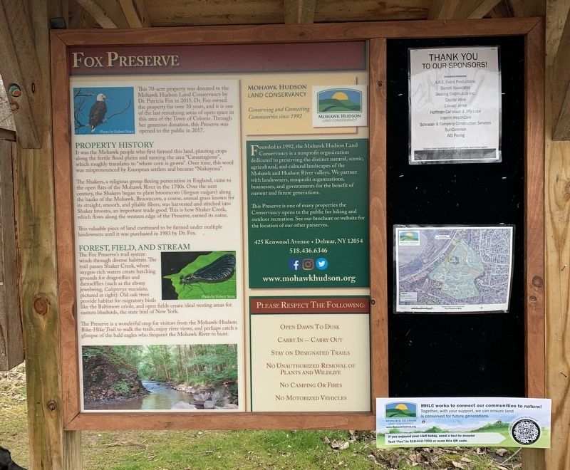
This 70-acre property was donated to the Mohawk Hudson Land Conservancy by
Dr. Patricia Fox in 2015. Dr. Fox owned the property for over 30 years, and it is one of the last remaining areas of open space in this area of the Town of Colonie. Through . . . — — Map (db m147937) HM
Through this Place Passed
Gen. Henry Knox
In the Winter of 1775 - 1776
To Deliver To
Gen. George Washington
At Cambridge
The Train of Artillery
From Fort Ticonderoga
Used to Force the British
Army to Evacuate Boston . . . — — Map (db m23749) HM
1755 Constructed as Military Road from
Albany to Lake George by Provincial
Troops from New York, New England
and New Jersey under command of
Major General William Johnson
———
Named in honor of Major General . . . — — Map (db m24514) HM
Farm of Arendt Van Curler
1643-1667. Pieter Schuyler
& Margarita Schuyler after
1672. Fortified 1747, and
Military Encampment 1750's
— — Map (db m184813) HM
The Boght
Settled On and After
1704 By The
Vischer Weaver Witbeck
Lansing Powell Runkle
Dunsbach Lieverse Staats
Roff Godfrey Van O Linde
Groesbeck Van Vranken Fero
Van De Mark Van Denburgh
Johnson Pollock Storms
Fonda and . . . — — Map (db m24731) HM
For nearly a century, canal boats were pulled by mules and horse over this portion of New York State's famed Erie Canal.
One of the slowest and most crowded parts of the waterway started to the north of the Flatts at Maplewood. Here Began the . . . — — Map (db m14742) HM
This Greek-revival building was one of several weigh stations along the Canal used to levy the tolls for barges carrying merchandise and farm goods.
Until 1850 freight cargoes were measured by the displacement theory, but this hydraulic type . . . — — Map (db m40999) HM
Erected In Honor Of
The Men And Women
Of The Town Of
Bethlehem
Who Served In The
Armed Forces
And In Memory Of
Those Who Made The
Supreme Sacrifice — — Map (db m142348) WM
Founded and Erected 1825. "For The Glory of God" quoted from 1824 land deed. Horse sheds built 1840. Fellowship hall added 1906. — — Map (db m97276) HM
Near here Andrew Hannay raised a company of volunteers October 1777
to oppose invasion of Burgoyne who surrendered before their arrival — — Map (db m135130) HM
The Elsmere Train Station
The hamlet of Elsmere represents the influence
which railroads had on the growth of suburban
communities. In 1863, when the first A&S Railroad train left Adams Station for Albany, the area now known as Elsmere . . . — — Map (db m185915) HM
This trail is a 9-mile pathway which follows the old Albany and Susquehanna Railroad between Albany and Voorheesville. This pathway connects visitors with landscapes and communities, including the dramatic Normanskill Gorge in the City of . . . — — Map (db m185901) HM
Slingerland-
Lagrange Farm
Family Owned 12 Generations.
Stone House Built c.1750's.
Home of Revolutionary War
Soldier Albert Slingerland. — — Map (db m140968) HM
Col. Schenectady militia during American Revolution owned farm here 1765 to death in 1799. Buried on high knoll above reservoir. — — Map (db m144957) HM
The Capital District has long been important as a trading post, military objective and governmental center. Located near the juncture of the Hudson and Mohawk rivers, Albany has been the “crossroads” of the northeast since . . . — — Map (db m56854) HM
Former estate of Judge Elisha Powell Hurlbut. Wrote "Rights of Woman" essay in 1841. Served on state suffrage committee 1880-1882. — — Map (db m223915) HM
Begun 1785 by Leonard De
Neuville. Known as Albany
Glass House, later Hamilton
Glass Wks. Made bottles &
window glass. Closed 1815
— — Map (db m50620) HM
Town Hall
Town of Guilderland
Est. April 4, 1803
First Officers; Supervisor
Nicholas V. Mynderse,
Clerk Peter G. Veeder
Town of Guilderland 1985
— — Map (db m103165) HM
Jacob Van Aernam
1723 - 1813
Capt. 3rd Albany Regiment
Leader of Patriot forces
in the Helderberg region
during American Revolution
Lived on farm here — — Map (db m44020) HM
Locust Vale School
New Scotland School
District No. 11. Built about
1827 and closed 1939. Moved
to Meadowdale from Tygert
Road During the 1940's.
— — Map (db m48608) HM
Built Circa 1840
By John L. Schoolcraft
U.S. Congressman 1848-1852
Albany Banker and Whig Leader
Delegate to the 1860
National Convention
— — Map (db m65410) HM
Knox School District #5 was
formed in 1822. This school
was built in 1898, restored
by Kiwanis, & placed on the
National Register in 2005.
— — Map (db m52395) HM
Through this place passed
Gen. Henry Knox
in the Winter of 1775 - 1776
to deliver to
Gen. George Washington
at Cambridge
the train of artillery
from Fort Ticonderoga
used to force the British
Army to evacuate Boston . . . — — Map (db m23447) HM
Once called Ireland's Corners. Named in 1871 for Gen. John Campbell, 4th Earl of Loudoun.
Commander of His Majesty's forces - French & Indian Wars — — Map (db m142982) HM
Al-Tro Park In the 19th and early 20th centuries the Hudson River Islands offered places of escape and amusement to residents of Albany and Troy. In the early 20th century, this was the location of Al-Tro Park, an amusement park on what was . . . — — Map (db m227339) HM
Hudson River Island and I-787 Overlay This section of Interstate Route 787and the Mohawk-Hudson Bike-Hike Trail are located on several islands that used to exist along the west bank of the Hudson River. Some of the channels of the Little River . . . — — Map (db m226690) HM
Saint Agnes Cemetery has been placed on the National Register of Historic Places by the United States Department of the Interior 2008 — — Map (db m62357) HM
This was once the site of Troy Steel and Iron Company's blast furnace on Beeaker or Hillhouse Island. This island no longer exists; the tidal waters forming several islands on the west shore of the Hudson River were mostly filled in the 1960's with . . . — — Map (db m226374) HM
Original part built c. 1816. revolutionary War Captain. Served 3 area churches from 1794-1825. His descendants lived in home until 1922. — — Map (db m136073) HM
Land leased From Patroon
c.1779. Original House Is
Stone. Wood Sections Added
Later. Occupied by The
Allen Family over 100 Years.
— — Map (db m97288) HM
Built by Capt. Thomas Rogers
c.1820. Home of Aaron Hotaling.
owned for over 50 years by the
family of Arthur Pound, state
historian, poet & author. — — Map (db m142764) HM
Presented to the Town of New
Scotland, by the citizens of the
Town of New Scotland, with
stones gathered by the youth
of the town. Dedicated to
those who served and consecrated
by those who gave their lives
defending this flag and . . . — — Map (db m142767) WM
Baptist Church formed as "First Church of Rensselaerville." Proposed first Am. Baptist Missionary Society and Natl. Baptist Assembly, 1801. Church built, 1846. — — Map (db m241630) HM