On North Carson Street (Lincoln Highway) (Business U.S. 395) north of West Robinson Street, on the left when traveling north.
”Pony” Bob Haslam, considered to be the greatest of all Pony Express riders, rode for the Express from the beginning to the end. His route was through Carson City, one of the relay stations.
Erected by the Nevada Pony Express Centennial . . . — — Map (db m128553) HM
On South Carson Street (Business U.S. 395), on the right when traveling south.
[Front of Marker:]
Dedicated April 12, 1996
Carson City
Original Station
Apr. 3, 1860 - Nov. 20, 1861
by
Byron L. & Peggy Clark & Family
Bob & Tina McFadden
Mae & Jim Thorpe
The Bike Smith
Betty Young & Erica . . . — — Map (db m23038) HM
On West Appion Way at Snyder Avenue, on the right when traveling west on West Appion Way.
Centrally located between the first Nevada settlement at Genoa and the precious metal deposits of the Comstock Lode, Eagle Valley, site of present Carson City, was a vital link in land communications.
One of the key California emigrant routes, . . . — — Map (db m20802) HM
On North Carson Street at East Telegraph Street, on the right when traveling north on North Carson Street.
This imposing public structure, the former United States Post Office and Courthouse, represents the first federal office building constructed in the State of Nevada.
Construction began in late 1888 and was completed in 1891 at a cost of $138, . . . — — Map (db m101827) HM
On North Carson Street (Lincoln Highway) (Business U.S. 395) north of West Robinson Street, on the left when traveling north.
Honour to the Nevada men who were riders in the July 19 to 28, 1960 Centennial Reenactment of the Pony Express
Monument Erected by the
Pony Express Club of Nevada
National Pony Express Centennial Association
Dwight D. . . . — — Map (db m128554) HM
On North Carson Street at East Telegraph Street, on the right when traveling north on North Carson Street.
Carson City, Nevada, was one of the stations along the historic but hazardous 1966 mile Pony Express route between Sacramento Cal. and St. Joseph, Mo.
This monument is dedicated July 20, 1960 in memory of the Pony Express, during the epic . . . — — Map (db m101828) HM
On North Curry Street near West King Street, on the right when traveling south.
Completed in 1876, this palatial residence represents one of the finest and best preserved examples of High Victorian Italianate architecture remaining in the American West.
Charles H. Jones, a French-schooled designer, constructed the residence . . . — — Map (db m21246) HM
On North Maine Street (U.S. 95) just south of East A Street, on the right when traveling north.
In 1929, this building was deemed a magnificent improvement to the city. Built to U.S. Postal Service standards, this brick structure features massive single doors on either end of a vestibule that protects the inside from the elements. Carved . . . — — Map (db m142625) HM
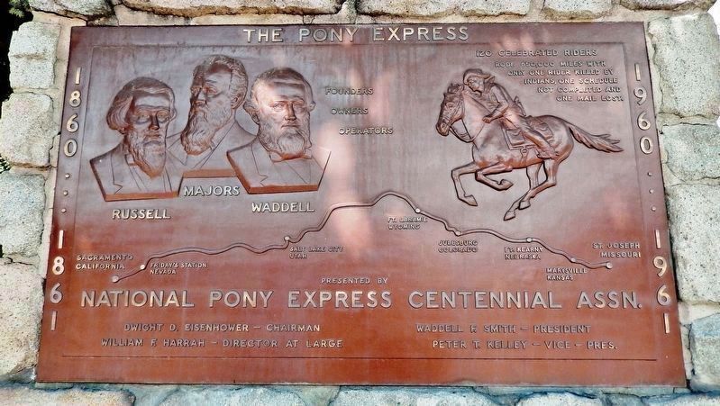
One hundred and fifty years ago, the Pony Express was founded by W. H. Russell, Alexander Majors and William B. Waddell, operators of the Overland Stage Line of Leavenworth, Kansas. During a visit to Washington, Mr. Russell was urged by California . . . — — Map (db m69681) HM
On U.S. 50, 11 miles north of Nevada Route 722, on the left when traveling north.
Replacement Marker
Rock Creek was an important stagecoach stop on the Overland Mail Stage Company's historic line along the Simpson route between Salt Lake City and Genoa, Nevada, which was operated by John Butterfield (1861-1866) and . . . — — Map (db m67144) HM
Two small rooms at the southwest end of the station were originally one large room and shared a common wood floor. The wall which now separates the two rooms was built on top of the floor some time later. The center room was probably used for . . . — — Map (db m127117) HM
Near Lincoln Avenue (U.S. 50) 25 miles east of Maine Street (U.S. 95), on the left when traveling east.
"The Mail Must Go Through"
From April 3, 1860 to November 21, 1861, mail was delivered by the Pony Express between St. Joseph, Missouri and Sacramento, California. It was a relay system between 190 stations along the route. A fresh horse was . . . — — Map (db m142572) HM
Near U.S. 50, 11 miles north of Nevada Route 722, on the right when traveling north.
Competing with time, distance, harsh climate, and hostile Indians, the Pony Express carried important communications from the East and the West across 2,000 miles in only 10 days.
The "Pony," as it was called, is an outstanding . . . — — Map (db m67142) HM
Near Lincoln Avenue (U.S. 50) 25 miles east of Maine Street (U.S. 95), on the left when traveling east.
Sand Springs Deserved its Name The rocks you see in front of you were once Sand Springs Pony Express Station. The Pony Express ended in November 1861, but this Station was used as a stopover for freight wagons until the late 1800s. It laid . . . — — Map (db m142573) HM
Near Nevada Route 361 south of Lincoln Highway (U.S. 50), on the right when traveling south.
Middlegate was named in 1850 by James Simson as he mapped the route for the Overland Stage Company. In his journal he writes that he thought the cuts in the mountains looked like 'gates' so he named each cut Westgate, Middlegate, and Eastgate to . . . — — Map (db m89452) HM
On 400 S. 7th Street at Stanley W Cooper Pl, on the right when traveling south on 400 S. 7th Street.
Charles "Pop" Squires, often referred to as "the Father of Las Vegas" lived at this location, with his wife, Delphine, from 1931 until his death 1958.
Squires first arrived in the Las Vegas Valley in February 1905. He and his partners . . . — — Map (db m131061) HM
On East Stewart Avenue at North Third Street on East Stewart Avenue.
This property
has been placed on the
National Register
of Historic Places
by the United States
Department of the Interior
United States Post Office
and Courthouse
c.1933 — — Map (db m47746) HM
On West Mesquite Boulevard, on the right when traveling west.
The Egg Association formed circa 1929 as a local cooperative, selling and distributing local eggs to tourist oriented businesses, or to market in Las Vegas. High school boys studying agriculture were part of the enterprise. The Association built a . . . — — Map (db m46746) HM
On Eddy Street, 0.1 miles U.S. 395, on the left when traveling west.
Built in the early 1900’s and known at
that time as the “Nevada Consolidated
Telephone and Telegraph Company,” only
five telephone lines were originally
installed in Gardnerville. “Long
Distance Connections . . . — — Map (db m15835) HM
On Eddy Street west of Main Street, on the right when traveling west.
The Record Courier has been published in Douglas County since 1904 when Dr. Southworth merged the Gardnerville Record and the Genoa Weekly Courier into one newspaper. In 2004 the Record Courier marks a solid century of printing.
This building . . . — — Map (db m28071) HM
On Genoa Lane at Jackson Valley Road/Main Street (Nevada Route 206), on the right when traveling west on Genoa Lane.
Born: April 30, 1827, Tinn, Telemark, Norway
Emigrated to America from Norway: May 30, 1837
Carried the mail: January 1856 – May 1876 (Twice a month -
during the winter for 20 years.)
Distance: 90 miles between Placerville, Ca and . . . — — Map (db m20679) HM
On Jacks Valley Road/Main Street (Nevada Route 206), on the right when traveling south.
Born April 30, 1827 at Upper Tinns, Telemark District of Norway, John A. “Snowshoe” Thompson’s parents Tosten Olsen and Gro Johnsdotter baptized him as John Tostensen. At an early age he learned to “snow skate” (snow ski). In . . . — — Map (db m20712) HM
[Upper Marker:]
As a Tribute
To a great compatriot from Telemark
This plaque was presented
by the Norwegian Olympic Ski Team
Competing at Sqaw Valley
In February 1960
[Lower Marker:]
Dedicated to
John A. . . . — — Map (db m20748) HM
Genoa's first two-story brick mansion
built for his bride in 1855-56 by Mormon
Station locator Stephen Kinsey, editor of
the first newspaper (handwritten). It was
the third land claim in Nevada. It was the
site of elegant socials and the Genoa . . . — — Map (db m135908) HM
On Main Street at Genoa Lane (Nevada Route 206), on the right when traveling north on Main Street.
Panel One:
Utah Territory
The area now making up the state of Nevada was acquired by the United States after the Mexican-American War. This newly acquired land was generally labeled as unorganized territory until 1850. The State of . . . — — Map (db m227650) HM
On Main Street at Mill Street, on the left when traveling north on Main Street.
In 1851, George Chorpenning and fellow Pennsylvania entrepreneur Absalom Woodward received a contract for $14,000 from the U.S. Post Office to establish the first U.S. Mail service between Sacramento, CA and Salt Lake City, UT. The monthly trip was . . . — — Map (db m223623) HM
On Mill Street west of Main Street, on the right when traveling west.
The Territorial Enterprise, a newspaper founded in Genoa in 1858 was at this location and one other in the town. The press was later moved to Carson City and then Virginia City. The first telegraph office in Nevada was also located on this block. . . . — — Map (db m169650) HM
We Salute John “Snowshoe” Thompson
On his homemade snowshoes John carried the mail and supplies over the snowy Sierras for 20 winters. As he traveled, he saved the lives of seven people who were snowbound in mountain cabins. In . . . — — Map (db m20729) HM
On US Highway 50 (U.S. 50) near Lake Parkway, on the left when traveling east.
(back) The Pony Express Started on April 3, 1860. The original route from Johnson Pass (Echo Summit) to Genoa went through Hope Valley to Woodfords Station.
On May 14, 1860 the new toll road over Daggett Pass opened to foot and horse . . . — — Map (db m432) HM
On U.S. 395 north of Church Street, on the left when traveling north.
The members of the Minden Town Board selected this site, on the Minden-Gardnerville boundary and adjacent to the telephone company offices, as a particularly appropriate location for what they have named "Sunset Park".
In the early 1900's, . . . — — Map (db m55510) HM
On Lake Tahoe Boulevard (U.S. 50), on the right when traveling east.
In commemoration of The Pony Express, a fleeting but exciting epoch in the winning of the West.
Erected April 4, 1963 by Harrah’s, William F. Harrah, President.
The first Pony Express rider passed here April 4, 1860 on his way to Friday’s . . . — — Map (db m46433) HM
On April 6, 1926, Varney Air Lines pilot Leon Cuddeback, carrying one bag of mail, landed his tiny Curtis Swallow bi-plane at Elko, Nevada, completing the first scheduled air mail run in the United States.
The single engine, 90-horsepower . . . — — Map (db m1371) HM
Approximately 200 feet east of this site is the early location of Elko's first newspaper. Founded June 19, 1869 by former miner Edward Davison Kelly, when Elko was just six months old. The Independent has been in continuous publication ever since. — — Map (db m89505) HM
On Idaho Street, 0.2 miles north of 14th Street, on the left when traveling north.
The Pony Express was the first attempt to have fast mail service to California. This was done through the personal drive and bravery of very young men who were responsible for bringing the mail and other “Deliverables” to the western . . . — — Map (db m146800) HM
On Idaho Street, on the right when traveling west.
Constructed on Sherman Creek in Huntington Valley, 60 miles south of Elko, by rancher Valentine Walther. It took Walther, family and friends seven years to complete and was finished in 1903. The house served as a home, post office, stage stop and . . . — — Map (db m1431) HM
On Main Street, on the right when traveling north.
The building was moved from Cornicopia Nevada to its present site in 1877. In 1881 it was purchased by Elizabeth Zweifel.
Through the years it has served as a rooming house, post office, telephone office, justice court, law office and school . . . — — Map (db m89477) HM
Near Wendover Boulevard (Business Interstate 80) west of Aria Boulevard, on the right when traveling west.
On June 17, 1914 the First Transcontinental Telephone Line was completed at this point on the border of Nevada and Utah. Construction forces of the Bell Telephone Company of Nevada and the Mountain States Telephone and Telegraph Company met here, . . . — — Map (db m131438) HM
Near Wendover Boulevard west of North Gene L. Jones Way, on the right when traveling west.
On June 17, 1914, AT&T erected the last of some 130,000 poles at Wendover, and the wires were spliced, joining more than 3,400 miles of telephone line. This splice connected the first telephone line from the East Coast to the West Coast across the . . . — — Map (db m226390) HM
On Ramsey Street at Columbia Street, on the left when traveling east on Ramsey Street.
This building was the communications center of Goldfield from 1908 until 1963. The Consolidated Telephone – Telegraph Company Building was one of the few spared by a fire that destroyed 53 blocks of the downtown area in 1923. Today, this building . . . — — Map (db m234151) HM
On Ramsey Street east of Columbia Avenus, on the right when traveling east. Reported permanently removed.
This was the communications center of Goldfield from 1906 until 1963. From 1904 to 1920, Goldfield boomed as a gold producing center. It was the largest (20,000+) city in Nevada during that period, having four railroads and other modern . . . — — Map (db m114228) HM
On Nevada Route 278 at milepost 14.7, on the right when traveling north.
The first known explorer of Diamond Valley was Colonel John C. Fremont, who mapped the area to aid western migration in 1845. Before Fremont, tribes of Shoshone and Paiute Indians long had gathered nature's bounty here.
Colonel J.H. Simpson . . . — — Map (db m69606) HM
On Monroe Street at Ruby Hill Avenue, on the left when traveling north on Monroe Street.
Constructed in 1879 at a cost of $10,000, the Sentinel Building was designed by architect C.M. Bennett. The Eureka Sentinel was published in this building from 1879 to 1960. Three generations of the Skillman family, Archibald, Edward and Willis, . . . — — Map (db m14686) HM
On Monroe Street at Ruby Hill Avenue, on the left when traveling north on Monroe Street.
When A. Skillman closed the Shermantown Reporter at Hamilton he moved is printing press to Eureka. Together with Dr. L.C. McKenny they started the Sentinel as a weekly paper in July 1870. It became a daily in June 1871 reporting local and . . . — — Map (db m14687) HM
On Museum Avenue near Maple Avenue, on the left when traveling west.
In 1868 the Central Pacific Railroad (CPR) was completed from Sacramento to Winnemucca and the first locomotive, the Champion, traveled to Winnemucca. On May 10, 1869 the CPR and the Union Pacific Railroad (UPR) were joined at Promontory, Utah. On . . . — — Map (db m141451) HM
The Pony Express Trail passed four miles north of Austin through Jacobsville, Simpson's Park and Dry Creek Station. During the Paiute Indian War the stations were burned and two station tenders at Dry Creek were killed and buried there.
. . . — — Map (db m14607) HM
On U.S. 93 at First South, on the left when traveling north on U.S. 93.
“The Rolling Stones of Pahranagat,” a hoax article on magnetic currents written in 1862 by Dan deQuille of the Territorial Enterprise, made this valley world famous. Its lakes are filled and its fields are irrigated by three springs, Hiko, Crystal . . . — — Map (db m1290) HM
On West Main Street at Pike Street, on the right when traveling west on West Main Street.
{Obverse:}
Dedicated September 15, 2001
NEVADA
Added Station
Jul. 1, 1861 - Nov. 20, 1861
By
Bennetts Family
James Stretesky
Dayton Historic Society
Don, Nancy, Jody & Jeff Dallas
Robert & Rae Marie Foster Family . . . — — Map (db m29750) HM
On Main Street at Dayton Valley Road, on the right when traveling north on Main Street.
Dayton was an important point on the Pony Express route. The site of the old station is approximately 200 yards northwest near the old firehouse. — — Map (db m69689) HM
On Main Street at Pike Street, on the left when traveling west on Main Street.
The original Union Hotel was located across the street. It was rebuilt here in 1870 after a fire destroyed the old hotel. The former post office site originally housed the dining room and barber shop. The freestanding rock wall is the original . . . — — Map (db m89513) HM
On Moonlight Road east of Red Rock Road, on the left when traveling north.
Along this ridge was the trail of the P/X from St. Joseph, Missouri to Sacramento/San Francisco, California and return. This segment was from Hall's Station (Dayton) to Carson City P/X Office on the west side of Carson St. just north of 5th Street. . . . — — Map (db m184147) HM
On Cheyenne Drrive at Lincoln Highway (U.S. 50), on the right when traveling south on Cheyenne Drrive.
Located approximately one mile south are the remains of a typical stage station of the period 1843 to 1869. An era of transition between the arrival of the first emigrant wagon trains and the completion of the Trans-Continental Railroad.
Desert . . . — — Map (db m89512) HM
Near U.S. 95 south of Fort Churcholl Road, on the left when traveling south.
In the spring of 1860, in the midst of the Pyramid Lake War, Robert "Pony Bob"
Haslam left Friday's Station (Lake Tahoe) with the eastbound mail and made his
way toward Buckland Station. When Pony Bob reached the Carson River, 60 miles
into . . . — — Map (db m171428) HM
On Main Street south of Virginia Street, on the right when traveling south.
Formed in the early 1890s and enduring a succession of owners. The "telephone" was introduced at Yerington in 1898. Dr. Granville Leavitt, Ed Lamb and JI Wilson were the principles in constructing the first line into town from Wabuska. Twelve miles . . . — — Map (db m171936) HM
Near Berlin Ichthyosaur State Park Road, 2 miles south of Nevada Route 844, on the left when traveling south.
The stage driver and his horses were housed under one roof in this building. A partition made of lumber separated the dwelling section from the barn. A small corral was attached to the south section and the door leading into the barn could be closed . . . — — Map (db m89582) HM
On Fremont Route (Highway 376), on the right when traveling north.
Long after the railroads came to Nevada and branch lines were extended towards the heartland of the state, horse-drawn stages transported people and mail from railhead to the hinterlands. The principal routes were covered by such well-known lines . . . — — Map (db m89421) HM
On C Street (Nevada Route 341), on the left when traveling south.
Young love to the sea. Intense and critical love for place
and people . . . Editor of the Territorial Enterprise where
he reigned intense and critical . . . "High" Commodore of the
Virginia City Yacht Club . . . To those who loved him,
"A . . . — — Map (db m174098) HM
On C Street (Nevada Route 341), on the right when traveling south.
Early pioneer of both the telegraph and telephone. He was builder of the first telegraph lines across the Sierra’s from Placerville to Genoa then on to Virginia City. He also had the distinction of telegraphing Nevada’s Constitution to President . . . — — Map (db m22342) HM
On C Street (Nevada Route 341), on the left when traveling north.
Dedicated to two of Nevada’s brawniest pioneers: James T. Fennimore, who, on a wild night in 1859, christened this town Virginia – and to John “Snowshoe” Thompson who carried the mails on homemade skis during the crescent years of the Comstock . . . — — Map (db m21825) HM
On South D Street, on the right when traveling north.
The Gould & Curry Mining Co. office escaped the 1875 fire to also become the home of John Mackay, “Boss” of the Big Bonanza, which made him the richest man in the Comstock (over $100,000,000). Mackay also founded the Postal Telegraph Co. — — Map (db m21595) HM
On South C Street (Nevada Route 341), on the right when traveling north.
100 years ago, in 1864, Samuel Clemens left the Territorial Enterprise, moving on to California and world-wide fame. He was a reporter here in 1863 when he first used the name, Mark Twain. He later described his colorful adventures in Nevada in . . . — — Map (db m22682) HM
On C Street (Nevada Route 341) near Union Street, on the right when traveling south.
In the early 1860’s the office of the Territorial Enterprise newspaper was located in this building. MARK TWAIN worked for the newspaper here from 1862 till 1864. — — Map (db m209198) HM
On South C Street (Nevada Route 341), on the right when traveling north.
Near this site Nov. 3, 1860 was published the first Territorial Enterprise under a Virginia City dateline. Born 1858 at Genoa the Enterprise was to become a celebrated property of the Old West whose Editors, Joe Goodman, Rollin Daggett, Mark Twain, . . . — — Map (db m21693) HM
On C Street (Nevada Route 341), on the left when traveling north.
Worked as a reporter for the Territorial Enterprise from 1861 until 1885, re-joined the paper in 1887 and continued working until the paper ceased operation.
While as a reporter he was the author of several books. His most famous was the . . . — — Map (db m21718) HM
On South Virginia Street (Nevada Route 430), on the right when traveling north.
Frederick Joseph DeLongechamps was Nevada’s foremost architect of his time. Statewide he was prolific in the number of buildings he designed. From this point one can see a group of structures that stand, collectively, as a monument to . . . — — Map (db m44217) HM
On U.S. 93 at milepost 93, on the right when traveling north.
Schellbourne, in the foothills of the Schell Creek Range, was a Shoshone village site long before it began its recent historic career in 1859. Captain James Simpson passed through the site and this point, looking for a short route across the Great . . . — — Map (db m1304) HM
Near U.S. 93 at White Pine County Road 18 (Nevada Route 893), on the right when traveling north.
The first teams of Pony Express riders amazed the nation by accomplishing their east and west bound deliveries within the projected 10 day schedule. The speed of the riders even had a role in swaying a divided California to stay with the union . . . — — Map (db m67128) HM
Near U.S. 93 at White Pine County Road 18 (Nevada Route 893), on the right when traveling north.
Descriptions of the variety and number of horses used by the Pony Express became distorted during the course of its history since November 1861. In general, the type of horse used for carrying the rider and mail depended greatly on the region. The . . . — — Map (db m67127) HM
Near U.S. 93 at White Pine County Road 18 (Nevada Route 893), on the right when traveling north.
In 1845, it took six months to get a message from the East Coast of the United States to California. By the late 1850s, a half million people had migrated west and were demanding up-to-date news from home. Something had to be done to deliver mail . . . — — Map (db m67129) HM
Near U.S. 93 at White Pine County Road 18 (Route 893), on the right when traveling north.
Mail From Coast to Coast: During the mid-1800s, American settlers were on the move, relocating from crowded Eastern cities to the untamed wilderness of the West. Many made their way to California. With the surge of settlers, California began . . . — — Map (db m67130) HM