By Cosmos Mariner, July 27, 2014
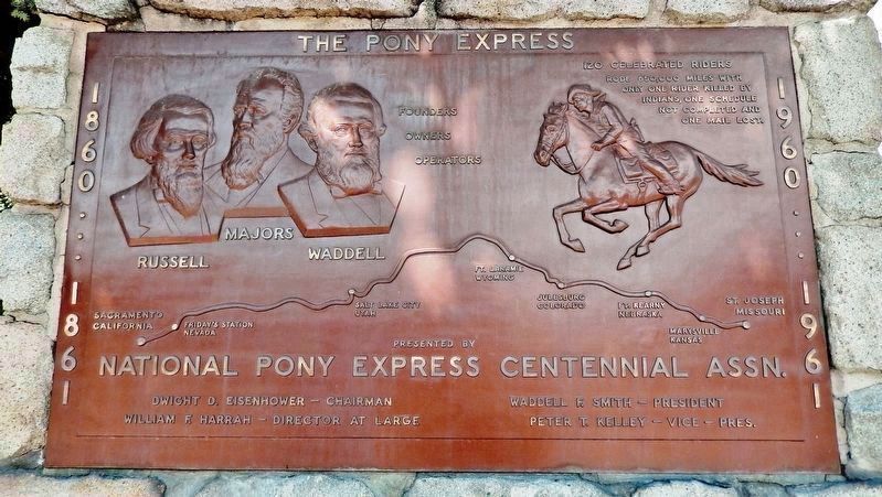
National Pony Express Centennial Association Plaque (mounted above marker)
| On North Carson Street (Lincoln Highway) (Business U.S. 395) north of West Robinson Street, on the left when traveling north. |
| On South Carson Street (Business U.S. 395), on the right when traveling south. |
| On West Appion Way at Snyder Avenue, on the right when traveling west on West Appion Way. |
| On North Carson Street at East Telegraph Street, on the right when traveling north on North Carson Street. |
| On North Carson Street (Lincoln Highway) (Business U.S. 395) north of West Robinson Street, on the left when traveling north. |
| On North Carson Street at East Telegraph Street, on the right when traveling north on North Carson Street. |
| On North Curry Street near West King Street, on the right when traveling south. |
| On North Maine Street (U.S. 95) just south of East A Street, on the right when traveling north. |
| Near Salt Wells Road, 6.5 miles south of U.S. 50. |
| On U.S. 50, 11 miles north of Nevada Route 722, on the left when traveling north. |
| Near US Highway 50 (U.S. 50). |
| Near Lincoln Avenue (U.S. 50) 25 miles east of Maine Street (U.S. 95), on the left when traveling east. |
| Near U.S. 50, 11 miles north of Nevada Route 722, on the right when traveling north. |
| Near Lincoln Avenue (U.S. 50) 25 miles east of Maine Street (U.S. 95), on the left when traveling east. |
| Near Nevada Route 361 south of Lincoln Highway (U.S. 50), on the right when traveling south. |
| On 400 S. 7th Street at Stanley W Cooper Pl, on the right when traveling south on 400 S. 7th Street. |
| Near Fremont Street at South Main Street. |
| On East Stewart Avenue at North Third Street on East Stewart Avenue. |
| On West Mesquite Boulevard, on the right when traveling west. |
| Near Las Vegas Boulevard South (Nevada Route 159) 0.4 miles south of West Russell Road. |
| On Eddy Street, 0.1 miles U.S. 395, on the left when traveling west. |
| On Eddy Street west of Main Street, on the right when traveling west. |
| On Genoa Lane at Jackson Valley Road/Main Street (Nevada Route 206), on the right when traveling west on Genoa Lane. |
| On Jacks Valley Road/Main Street (Nevada Route 206), on the right when traveling south. |
| Near Jacks Valley Road (Nevada Route 206). |
| On Genoa Lane, on the left when traveling east. |
| On Main Street at Genoa Lane (Nevada Route 206), on the right when traveling north on Main Street. |
| On Genoa Lane at Main Street (Nevada Route 206), on the left when traveling west on Genoa Lane. |
| On Main Street at Mill Street, on the left when traveling north on Main Street. |
| On Mill Street west of Main Street, on the right when traveling west. |
| Near Jacks Valley Road (Nevada Route 206). |
| On US Highway 50 (U.S. 50) near Lake Parkway, on the left when traveling east. |
| On U.S. 395 north of Church Street, on the left when traveling north. |
| On Lake Tahoe Boulevard (U.S. 50), on the right when traveling east. |
| On 4th Street at Railroad Street on 4th Street. |
| On Idaho Street, 0.2 miles north of 14th Street, on the left when traveling north. |
| On Idaho Street, on the right when traveling west. |
| On Idaho Street, on the right when traveling west. |
| On Main Street, on the right when traveling north. |
| Near Wendover Boulevard (Business Interstate 80) west of Aria Boulevard, on the right when traveling west. |
| Near Wendover Boulevard west of North Gene L. Jones Way, on the right when traveling west. |
| On Ramsey Street at Columbia Street, on the left when traveling east on Ramsey Street. |
| On Ramsey Street east of Columbia Avenus, on the right when traveling east. Reported permanently removed. |
| On Nevada Route 278 at milepost 14.7, on the right when traveling north. |
| On Monroe Street at Ruby Hill Avenue, on the left when traveling north on Monroe Street. |
| On Monroe Street at Ruby Hill Avenue, on the left when traveling north on Monroe Street. |
| On Museum Avenue near Maple Avenue, on the left when traveling west. |
| On Highway 50, on the right when traveling east. |
| On U.S. 93 at First South, on the left when traveling north on U.S. 93. |
| On West Main Street at Pike Street, on the right when traveling west on West Main Street. |
| On Main Street at Dayton Valley Road, on the right when traveling north on Main Street. |
| On Main Street at Pike Street, on the left when traveling west on Main Street. |
| On Moonlight Road east of Red Rock Road, on the left when traveling north. |
| On Cheyenne Drrive at Lincoln Highway (U.S. 50), on the right when traveling south on Cheyenne Drrive. |
| Near U.S. 95 south of Fort Churcholl Road, on the left when traveling south. |
| On Main Street south of Virginia Street, on the right when traveling south. |
| Near Berlin Ichthyosaur State Park Road, 2 miles south of Nevada Route 844, on the left when traveling south. |
| On Fremont Route (Highway 376), on the right when traveling north. |
| On C Street (Nevada Route 341), on the left when traveling south. |
| On C Street (Nevada Route 341), on the right when traveling south. |
| On C Street (Nevada Route 341), on the left when traveling north. |
| On South D Street, on the right when traveling north. |
| On South C Street (Nevada Route 341), on the right when traveling north. |
| On C Street (Nevada Route 341) near Union Street, on the right when traveling south. |
| On South C Street (Nevada Route 341), on the right when traveling north. |
| On C Street (Nevada Route 341), on the left when traveling north. |
| On South Virginia Street (Nevada Route 430), on the right when traveling north. |
| On Plumas St, on the right when traveling south. |
| On U.S. 93 at milepost 93, on the right when traveling north. |
| Near U.S. 93 at White Pine County Road 18 (Nevada Route 893), on the right when traveling north. |
| Near U.S. 93 at White Pine County Road 18 (Nevada Route 893), on the right when traveling north. |
| Near U.S. 93 at White Pine County Road 18 (Nevada Route 893), on the right when traveling north. |
| Near U.S. 93 at White Pine County Road 18 (Route 893), on the right when traveling north. |