After filtering for Maryland, 454 entries match your criteria. The first 100 are listed. ⊳
War of 1812 Topic
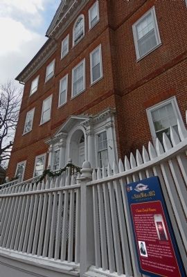
By Allen C. Browne, February 8, 2013
Chase-Lloyd House Marker
| 1 ► Maryland, Anne Arundel County, Annapolis — 6 — Chase-Lloyd House — The Naval War of 1812 in Annapolis — Don't Give Up the Ship — |
| On Maryland Avenue at King George Street, on the left when traveling east on Maryland Avenue. | |||
| 2 ► Maryland, Anne Arundel County, Annapolis — Commodore John Barry — Commission Number One United States Navy — |
| On Prince George Street west of Craig Street, on the right when traveling west. | |||
| 3 ► Maryland, Anne Arundel County, Annapolis — 5 — HMS Confiance Cannon — The Naval War of 1812 in Annapolis — Don't Give Up the Ship — |
| On NE Arcade Road. | |||
| 4 ► Maryland, Anne Arundel County, Annapolis — 2 — HMS Macedonian Monument — The Naval War of 1812 — Don't Give Up The Ship — |
| Near Maryland Avenue. | |||
| 5 ► Maryland, Anne Arundel County, Annapolis — 4 — Joseph Nicholson Home Site and Bandstand — The Naval War of 1812 in Annapolis — Don't Give Up The Ship — |
| Near Blake Road. | |||
| 6 ► Maryland, Anne Arundel County, Annapolis — Macedonian Monument — |
| On Maryland Avenue, on the right when traveling east. | |||
| 7 ► Maryland, Anne Arundel County, Annapolis — 1 — Mahan Hall — The Naval War of 1812 in Annapolis — Don't Give Up the Ship! — |
| Near Maryland Avenue. | |||
| 8 ► Maryland, Anne Arundel County, Annapolis — 9 — Maryland State House — The Naval War of 1812 in Annapolis — Don't Give Up the Ship! — |
| On State Circle. | |||
| 9 ► Maryland, Anne Arundel County, Annapolis — On this spot — The Star Spangled Banner — |
| On Blake Road. | |||
| 10 ► Maryland, Anne Arundel County, Annapolis — Site of Old Fort Severn — |
| On Cooper Road, 0.1 miles south of Santee Road. | |||
| 11 ► Maryland, Anne Arundel County, Annapolis — Standing Guard — Star-Spangled Banner National Historic Trail — National Park Service, U.S. Department of the Interior — |
| On Jonas Green Park Road. | |||
| 12 ► Maryland, Anne Arundel County, Annapolis — The City Spared — Star-Spangled Banner National Historic Trail — War of 1812 — |
| On West Street. | |||
| 13 ► Maryland, Anne Arundel County, Annapolis — 3 — U.S. Naval Academy Museum — The Naval War of 1812 — Don't Give Up The Ship — |
| On Maryland Avenue, on the left when traveling east. | |||
| 14 ► Maryland, Anne Arundel County, Annapolis, Naval Academy — British 24 Pounder — |
| Near Holloway Road. | |||
| 15 ► Maryland, Anne Arundel County, Annapolis, Naval Academy — Fort Nonsense — |
| Near Kinkaid Road close to Church Road. | |||
| 16 ► Maryland, Anne Arundel County, Annapolis, St. John's College — Francis Scott Key — 1814 - 1914 — |
| Near College Avenue (Maryland Route 450) at Prince George Street, on the left when traveling east. | |||
| 17 ► Maryland, Anne Arundel County, Annapolis, St. John's College — 7 — St. John's College — The Naval War of 1812 in Annapolis — Don't Give Up the Ship |
| On College Avenue at Prince George Street, on the right on College Avenue. Reported permanently removed. | |||
| 18 ► Maryland, Anne Arundel County, Annapolis, St. John's College — This Cannon — |
| Near College Avenue (Maryland Route 450) at Prince George Street, on the left when traveling east. | |||
| 19 ► Maryland, Anne Arundel County, Edgewater — Java Plantation Life — Old Fields to New Plantations — |
| On Dock Road. | |||
| 20 ► Maryland, Anne Arundel County, Edgewater — Prized Property — Star-Spangled Banner National Historic Trail — War of 1812 — |
| On Contee's Wharf Road. | |||
| 21 ► Maryland, Anne Arundel County, Glen Burnie — Defending the Chesapeake Bay — Star Spangled Banner National Historic Trail — |
| On Crain Highway (Business Maryland Route 3) 0.1 miles south of Baltimore Annapolis Boulevard (Maryland Route 648), on the right when traveling north. | |||
| 22 ► Maryland, Anne Arundel County, Linthicum Heights — Benson-Hammond House — |
| On N. Camp Meade Rd (Maryland Route 170) 0.1 miles north of Maple Road. | |||
| 23 ► Maryland, Anne Arundel County, Linthicum Heights — The Heart Spoke — Star-Spangled Banner National Historic Trail — |
| On Oak Twin Court at Historical Way, on the left on Oak Twin Court. | |||
| 24 ► Maryland, Anne Arundel County, Lothian — Bitter End — Star-Spangled Banner National Historic Trail — War of 1812 — |
| On Marlboro Road. | |||
| 25 ► Maryland, Anne Arundel County, Pasadena — Observing the Enemy — Star-Spangled Banner National Historic Trail — |
| On Bayside Beach Road, 2.3 miles east of Fort Smallwood Road (Route 173), on the right when traveling east. | |||
| 26 ► Maryland, Anne Arundel County, Pasadena — Prime View — Star-Spangled Banner National Historic Trail — National Park Service, U.S. Department of the Interior — |
| On Bay Front Drive, 0.5 miles north of Fort Smallwood (Route 173), on the right. | |||
| 27 ► Maryland, Anne Arundel County, Shady Side — Cannon - From Shady Side's Rural Home Hotel — |
| On East West Shady Side Road west of Bast Avenue, on the right when traveling north. | |||
| 28 ► Maryland, Anne Arundel County, Skidmore — Tense Time — Star-Spangled Banner National Historic Trail — War of 1812 — |
| On South Beach Road. | |||
| 29 ► Maryland, Anne Arundel County, Tracys Landing — Outnumbered — Star-Spangled Banner National Historic Trail — War of 1812 — |
| On Herring Bay Road. | |||
| 30 ► Maryland, Baltimore, Canton — Former Glory — Star-Spangled Banner National Historic Trail — War of 1812 — |
| On Boston Street at South Lakewood Avenue, on the right when traveling south on Boston Street. | |||
| 31 ► Maryland, Baltimore, Canton — Historic Canton — Viewing the Entrance to the Baltimore Harbor from the Canton Waterfront Park — |
| On Boston Street at South Potomac Street, on the right when traveling east on Boston Street. | |||
| 32 ► Maryland, Baltimore, Clifton Park — Mounted Messengers — Star-Spangled Banner National Historic Trail — National Park Service, U.S. Department of the Interior — |
| On St Lo Drive. | |||
| 33 ► Maryland, Baltimore, Downtown — Discover Baltimore: The Monumental City — Heritage Walk — |
| Near North Calvert Street (Maryland Route 2) north of East Fayette Street, in the median. | |||
| 34 ► Maryland, Baltimore, Downtown — Inspired Words — Star-Spangled Banner National Historic Trail — War of 1812 — |
| On Hopkins Plaza-West Baltimore Street. | |||
| 35 ► Maryland, Baltimore, Downtown — On This Location — |
| Near Holliday Street at Fayette Street. | |||
| 36 ► Maryland, Baltimore, Downtown — The Battle Monument — |
| On Calvert Street at Fayette Street, in the median on Calvert Street. | |||
| 37 ► Maryland, Baltimore, Downtown — The Battle Monument — |
| 38 ► Maryland, Baltimore, Downtown — The Battle Monument — |
| On North Calvert Street (Maryland Route 2) at East Fayette Street, in the median on North Calvert Street. | |||
| 39 ► Maryland, Baltimore, Federal Hill — Colonel George Armistead — |
| Near Warren Avenue. | |||
| 40 ► Maryland, Baltimore, Federal Hill — Major General Samuel Smith — 1752–1839 — |
| Near Warren Avenue. | |||
| 41 ► Maryland, Baltimore, Fells Point — “Baltimore must be tamed…” — Star-Spangled Banner National Historic Trail — War of 1812 — |
| On Broadway. | |||
| 42 ► Maryland, Baltimore, Fells Point — The Chesapeake Campaign & The War of 1812 — Fell's Point National Register Historic District and Ft. McHenry National Monument — |
| On Thames Street at Broadway on Thames Street. | |||
| 43 ► Maryland, Baltimore, Fells Point — War in the Chesapeake — Star-Spangled Banner National Historic Trail — War of 1812 — |
| On Broadway. | |||
| 44 ► Maryland, Baltimore, Fort McHenry — Living Memorials — |
| On East Fort Avenue. | |||
| 45 ► Maryland, Baltimore, Inner Harbor — Baltimore Turns the Tide — Star-Spangled Banner National Historic Trail — National Park Service, U.S. Department of the Interior — |
| On Light Street (Maryland Route 2) at East Conway Street, on the right when traveling north on Light Street. | |||
| 46 ► Maryland, Baltimore, Inner Harbor — Baltimore’s Maritime Heritage — Pride of Baltimore II — |
| On Light Street. | |||
| 47 ► Maryland, Baltimore, Inner Harbor — Mob Scene — Star-Spangled Banner National Historic Site — National Park Service, U.S. Department of the Interior — |
| On Charles Street at East Pratt Street on Charles Street. | |||
| 48 ► Maryland, Baltimore, Inner Harbor — M1986.88 — Private Armed Schooner of Baltimore — |
| Near Key Highway just east of William Street, on the right when traveling west. | |||
| 49 ► Maryland, Baltimore, Inner Harbor — Welcome — Heritage Walk — |
| On East Pratt Street just west of President Street, on the right when traveling east. | |||
| 50 ► Maryland, Baltimore, Inner Harbor — Welcome — Heritage Walk — |
| On East Pratt Street east of South Calvert Street (Maryland Route 2), on the left when traveling east. | |||
| 51 ► Maryland, Baltimore, Irvington — In Memory of Mary Young Pickersgill — 1776-1857 — |
| On Wilkens Aveune. | |||
| 52 ► Maryland, Baltimore, Irvington — Mary Pickersgill — |
| On Wilkens Aveune. | |||
| 53 ► Maryland, Baltimore, Jonestown — Crafting a Legacy — Star-Spangled Banner National Historic Trail — National Park Service, U.S. Department of the Interior — |
| On East Pratt Street. | |||
| 54 ► Maryland, Baltimore, Jonestown — Flag House — 1793-1957 — |
| Near East Pratt Street. | |||
| 55 ► Maryland, Baltimore, Jonestown — Home of Edward Johnson — Mayor of Baltimore 1808-1814 and 1822 — |
| On East Lombard Street on East Lombard Street. | |||
| 56 ► Maryland, Baltimore, Jonestown — The Flag House and Star-Spangled Banner Museum — |
| On East Pratt Street, on the left when traveling east. | |||
| 57 ► Maryland, Baltimore, Jonestown — The Star Spangled Banner — |
| On East Pratt Street near Albemarle Street, on the left when traveling east. | |||
| 58 ► Maryland, Baltimore, Jonestown — The Star Spangled Banner Flag was Born Here — |
| On South President Street. | |||
| 59 ► Maryland, Baltimore, Jonestown — Welcome To The Star-Spangled Banner Flag House — |
| Near Albemarle Street just north of East Pratt Street, on the right when traveling south. | |||
| 60 ► Maryland, Baltimore, Locust Point — Locust Point — |
| On Fort Avenue at Towson Street, on the right when traveling east on Fort Avenue. | |||
| 61 ► Maryland, Baltimore, Locust Point — This is Banner Field — Home of pride, inspiration & freedom — |
| On Andre Street, 0.1 miles south of East Fort Avenue, on the right when traveling south. | |||
| 62 ► Maryland, Baltimore, Locust Point Industrial Area — 1814 Enlisted Men's Barracks, No 2 — |
| On East Fort Avenue. | |||
| 63 ► Maryland, Baltimore, Locust Point Industrial Area — A Pivotal Battle — Star-Spangled Banner National Historic Trail — National Park Service, U.S. Department of the Interior — |
| Near East Fort Avenue. | |||
| 64 ► Maryland, Baltimore, Locust Point Industrial Area — A Star Spangled Centennial — |
| On East Fort Avenue. | |||
| 65 ► Maryland, Baltimore, Locust Point Industrial Area — Allegiance by Force — |
| Near East Fort Avenue. | |||
| 66 ► Maryland, Baltimore, Locust Point Industrial Area — Another Day on Duty… 1814 — |
| Near Constellation Plaza, 0.3 miles east of Wallace Street, on the right when traveling east. | |||
| 67 ► Maryland, Baltimore, Locust Point Industrial Area — Armistead — |
| Near East Fort Avenue. | |||
| 68 ► Maryland, Baltimore, Locust Point Industrial Area — Army "Sailors," Navy "Soldiers" — |
| On East Fort Avenue. | |||
| 69 ► Maryland, Baltimore, Locust Point Industrial Area — Bombproofs — |
| Near Constellation Plaza, 0.3 miles east of Wallace Street, on the right when traveling east. | |||
| 70 ► Maryland, Baltimore, Locust Point Industrial Area — British Bomb — |
| Near Constellation Plaza, 0.3 miles east of Wallace Street, on the right when traveling east. | |||
| 71 ► Maryland, Baltimore, Locust Point Industrial Area — Captain Francis Hancock — |
| Near Constellation Plaza, 0.1 miles east of Wallace Street, on the right when traveling east. | |||
| 72 ► Maryland, Baltimore, Locust Point Industrial Area — Cistern and Well — |
| Near East Fort Avenue. | |||
| 73 ► Maryland, Baltimore, Locust Point Industrial Area — Colonel Benjamin Fowler — |
| Near Constellation Plaza, 0.1 miles east of Wallace Street, on the right when traveling east. | |||
| 74 ► Maryland, Baltimore, Locust Point Industrial Area — Colonel William M. McDonald — |
| On Constellation Plaza, 0.1 miles east of Wallace Street. | |||
| 75 ► Maryland, Baltimore, Locust Point Industrial Area — Commanding Officer’s Quarters — |
| Near Fort Avenue. | |||
| 76 ► Maryland, Baltimore, Locust Point Industrial Area — Dawn's Early Light — 9:00 a.m., September 14, 1814 — |
| Near Constellation Plaza, 0.3 miles east of Wallace Street, on the right when traveling east. | |||
| 77 ► Maryland, Baltimore, Locust Point Industrial Area — Direct Hit |
| Near Constellation Plaza, 0.3 miles east of Wallace Street, on the right when traveling east. Reported permanently removed. | |||
| 78 ► Maryland, Baltimore, Locust Point Industrial Area — Direct Hits — 2:00 p.m. September 13, 1814 — |
| Near Constellation Plaza, 0.3 miles east of Wallace Street, on the right when traveling east. | |||
| 79 ► Maryland, Baltimore, Locust Point Industrial Area — Entering Fort McHenry … A Deadly Crossfire — |
| Near East Fort Avenue. | |||
| 80 ► Maryland, Baltimore, Locust Point Industrial Area — Evolution of Fort McHenry — |
| Near East Fort Avenue, on the right when traveling east. | |||
| 81 ► Maryland, Baltimore, Locust Point Industrial Area — Fort McHenry — 1814 - 1914 — |
| Near East Fort Avenue. | |||
| 82 ► Maryland, Baltimore, Locust Point Industrial Area — Fort McHenry National Monument & Historic Shrine — |
| Near Constellation Plaza, 0.4 miles east of Wallace Street, on the right when traveling north. | |||
| 83 ► Maryland, Baltimore, Locust Point Industrial Area — Francis Scott Key — |
| Near Constellation Plaza, 0.1 miles east of Wallace Street, on the right when traveling east. | |||
| 84 ► Maryland, Baltimore, Locust Point Industrial Area — Heritage of Courage…The Society of the War of 1812 — |
| Near Constellation Plaza, 0.3 miles east of Wallace Street, on the right when traveling east. | |||
| 85 ► Maryland, Baltimore, Locust Point Industrial Area — In Full Glory Reflected — 9:00 a.m., September 14, 1814 — |
| Near East Fort Avenue. | |||
| 86 ► Maryland, Baltimore, Locust Point Industrial Area — Lieutenant H.S. Newcomb — |
| Near Constellation Plaza, 0.1 miles east of Wallace Street, on the right when traveling east. | |||
| 87 ► Maryland, Baltimore, Locust Point Industrial Area — Lieutenant John A. Webster — |
| Near Constellation Plaza, 0.1 miles east of Wallace Street, on the right when traveling east. | |||
| 88 ► Maryland, Baltimore, Locust Point Industrial Area — Lieutenant John Frazier — |
| On Constellation Plaza, 0.1 miles east of Wallace Street, on the right when traveling east. | |||
| 89 ► Maryland, Baltimore, Locust Point Industrial Area — Lieutenant S. Rutter — |
| Near Constellation Plaza, 0.1 miles east of Wallace Street, on the right when traveling east. | |||
| 90 ► Maryland, Baltimore, Locust Point Industrial Area — Mortars vs. Guns — |
| Near East Fort Avenue, on the right when traveling east. | |||
| 91 ► Maryland, Baltimore, Locust Point Industrial Area — O Say Can You See? |
| Near Constellation Plaza east of Wallace Street, on the right when traveling east. Reported permanently removed. | |||
| 92 ► Maryland, Baltimore, Locust Point Industrial Area — O'er the Ramparts We Watch! — Which Flag Flies Today? — |
| Near East Fort Avenue. | |||
| 93 ► Maryland, Baltimore, Locust Point Industrial Area — Orpheus — |
| On Constellation Plaza, on the left when traveling west. | |||
| 94 ► Maryland, Baltimore, Locust Point Industrial Area — Orpheus… Hero of Music and Poetry — |
| Near East Fort Avenue. | |||
| 95 ► Maryland, Baltimore, Locust Point Industrial Area — Powder Magazine |
| Near East Fort Avenue. Reported permanently removed. | |||
| 96 ► Maryland, Baltimore, Locust Point Industrial Area — Providing For The Common Defense — |
| Near East Fort Avenue east of Wallace Street, on the right when traveling east. | |||
| 97 ► Maryland, Baltimore, Locust Point Industrial Area — Ravelin Magazine — |
| Near Constellation Plaza, 0.3 miles east of Wallace Street, on the right when traveling east. | |||
| 98 ► Maryland, Baltimore, Locust Point Industrial Area — Remember 1814 |
| Near East Fort Avenue, on the right when traveling east. Reported permanently removed. | |||
| 99 ► Maryland, Baltimore, Locust Point Industrial Area — Sailors Fighting Sailors — U.S. Chesapeake Flotilla vs. Royal Navy |
| Near East Fort Avenue. Reported permanently removed. | |||
| 100 ► Maryland, Baltimore, Locust Point Industrial Area — Star-Spangled Banner |
| Near East Fort Avenue. Reported permanently removed. | |||
454 entries matched your criteria. The first 100 are listed above. Next 100 ⊳