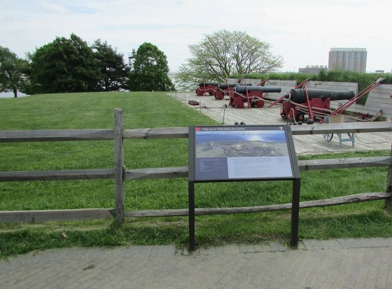
The gun deck in front of you is a partial representation of the forts 1814 Water Battery. Made up of 26 cannons in two tiers, the Water Battery comprised the fort's primary means of defense.
The Cannons that stood here fired shot weighing 18 . . . — — Map (db m60411) HM
These cannons represent the largest guns that defended the fort during the War of 1812. Cannons from this battery fired 18 and 36 pound iron balls almost a mile and a half. Heated cannonballs or “hot shot” proved especially devasting to wooden . . . — — Map (db m194419) HM
This wedge-shaped outwork protected the fort's sally port from enemy fire, and helped to control access to the star fort. The U.S. Army built the original ravelin in 1813. The structure was modified to its presents dimensions in 1837.
The . . . — — Map (db m194415) HM
Commanded a company of sea fencibles in the upper outside battery of Fort McHenry during its bombardment September 13th and 14th, 1814. — — Map (db m145563) HM WM
Commanded a company of sea fencibles in the upper outside battery of Fort McHenry during its bombardment September 13th and 14th, 1814. — — Map (db m145561) HM
An energetic Marylander, who fired the first shot of the War of 1812 and later organized the general artillery defense of Baltimore. — — Map (db m145569) HM
An able Baltimorean, who organized and commanded the Baltimore Gun Boat Flotilla for counter attack against the British fleet in the Chesapeake. — — Map (db m145567) HM
This tree dedicated to Edward Johnson, Mayor of Baltimore 1808 - 1816, who organized the resources of the people of Baltimore for the defense of their city. — — Map (db m145574) HM
Commanded 3rd Maryland Brigade which checked the British Army advance in the Battle of North Point, September 12th, 1814, and prevented the junction of the British Army and Navy opposite Fort McHenry. — — Map (db m145555) HM
Commanded the Battalion of the 5th MD. Regiment that first engaged the British advance at the Battle of North Point where their general, Sir Robert Ross, was killed September 12th, 1814. — — Map (db m145547) HM
Fort McHenry, like military bases today, comprised many buildings. If you were here in 1814, you would be standing on the edge of the outer drill field. Behind it stood two buildings: a gun shed, where small field cannons were stored, and a . . . — — Map (db m194435) HM
1780-1843 Presented to the City of Baltimore Charles L. Marburg
[this marker tells its story in a pictorial manner]
On one side, ships are depicted bombarding Fort McHenry. On the other, the view is from Fort McHenry out onto the ships in . . . — — Map (db m6548) HM
Three gun batteries hugging the upper shore of Ferry Branch guarded the west flank of Fort McHenry. They included the makeshift earthworks of Fort Babcock, the incomplete Fort Covington, and a temporary redoubt at Ferry Point.
During the . . . — — Map (db m79813) HM
Author of The Star Spangled Banner departed this life on the site of this building Jan. 11, 1843.
“And this be our motto In God is our Trust” —Key — — Map (db m5558) HM
At home in the city credited with helping to turn the tide for Americans in the War of 1812, the collections of the Maryland Historical Society preserve evidence of the people who live this history. The Center for Maryland History has the . . . — — Map (db m79842) HM
Daniel Wells, 19 and Henry McComas, 18, made history September 12, 1814, when they allegedly killed British commander Major General Robert Ross. The two sharpshooters fired simultaneously. Both were quickly shot dead by British . . . — — Map (db m154032) HM
On hill to the north stood the Georgian mansion built c. 1775 by Daniel Bowley II (1745–1807), Baltimore merchant and patriot of the revolution. He was a town commissioner, 1771–1778, and three times a State Senator. In 1814, British soldiers . . . — — Map (db m242400) HM
During the Civil War Patterson Park served as a U.S. Army camp, one of several established as part of the Federal occupation of Baltimore. In 1861 the 10th Maine Infantry Regiment occupied Camp Washburn (named for Maine Gov. Israel Washburn) in . . . — — Map (db m61888) HM
Events here October 4, 1808, known as “Gin Riots” were more rallies than riots. Some 1,300 horsemen, 400 sailors, and thousands of civilians paraded to Hampstead Hill to destroy 720 gallons of Dutch gin.
The British, intercepting . . . — — Map (db m79651) HM
After the stinging defeat at Bladensburg and invasion of Washington, Americans rallied to save Baltimore. All available able-bodied men were called to build defenses. Black and white, slave and free, united to dig earthworks across Hampstead Hill . . . — — Map (db m79653) HM
To Commemorate the
Centennial of the Writing of
the "Star Spangled Banner,"
the Pupils of the Public
Schools of Baltimore
have erected this Memorial
upon Hampstead Hill *
where, in September, 1814
the Citizen Soldiers
of Maryland . . . — — Map (db m61891) HM
This cannon marks Rodgers Bastion which formed part of a chain of fortifications extending from the river front to and beyond the site of the present Johns Hopkins Hospital, manned in part by an auxiliary naval force, under immediate command of . . . — — Map (db m79873) HM
During the War of 1812, a circular 180° earthen artillery redoubt was erected as a defense for Fort McHenry. On September 13, 1814, Lt. George Budd commanded naval forces that assisted in repulsing a nighttime British attack on the Ferry Branch . . . — — Map (db m36849) HM
During the Baltimore Railroad Riots of 1877, the park served as an encampment for the MD 5th Regiment, where they helped guard the South Baltimore rail lines after assisting with the riots downtown. On August 1st the MD 5th put on an exhibition . . . — — Map (db m212920) HM
Known as Lookout Hill, this high ground served as observation post, military camp, and gun battery. Although unfinished when the British arrived, the battery helped fend off a naval flanking attack September 14, 1814. Had the enemy maneuver . . . — — Map (db m79809) HM
The History Channel & Comcast
Present
The World Premiere of
First Invasion
The War of 1812
September 8, 2004
Gary L. Foreman, Producer/Director • Carolyn H. Raine, Producer • Dolores Gray, Exec. Producer • Martin . . . — — Map (db m188989) HM
"…and I feel pride in the belief that the stand made on Monday, in no small degree, tended to check the temerity of the foe, daring to invade a country like ours, and designing the destruction of our city..."
Brig. Gen. John . . . — — Map (db m6651) HM
Among
The Illustrious Men
interred within this enclosure who
assisted in the achievement of
National Independence
are the Following
─── ─── ───
In the Revolution and the War . . . — — Map (db m169993) WM
Once Baltimore’s most prestigious cemetery, Westminster Burying Ground was the final resting place for many prominent Baltimoreans, including some 25 from the War of 1812. Notable burials include: General Samuel Smith, commander of American . . . — — Map (db m194447) HM
Sam Smith is the most important public figure buried at Westminster. A hero in two wars, Smith (1752-1839) spent 40 years as a U.S. Congressman and Senator. As a merchant, Smith amassed and lost a fortune, but won the admiration of locals who, in . . . — — Map (db m6650) HM
Among the illustrious men interred within this enclosure who assisted in the achievement of National Independence in the Revolution and War of 1812 are the following Samuel Chase, 1741 – 1811, Signer of the Declaration of Independence . . . — — Map (db m21364) HM
SACRED to the memory of Aquila Randall, who died in bravely defending his Country and his Home, on the memorable 12th of September, 1814. Aged 24 years.
In the skirmish which occurred at this spot between the . . . — — Map (db m24034) HM
The narrow land shaped by Bear Creek, Bread and Cheese Creek, and Back River was the site of the Battle of North Point, September 12, 1814. Some 3,200 Americans clashed with 4,500 British to delay the advance on Baltimore.
When Britain threatened . . . — — Map (db m79747) WM
Here General Stricker’s City Brigade inflicted severe losses upon the main body of the British Army. This spirited defense together with that of Fort McHenry the next night saved Baltimore. — — Map (db m2118) HM
Erected by the Patriotic Order
Sons of America of Maryland,
In the year of the
National Star-Spangled Banner Centennial
1914.
This building, known as the
Battle Ground Methodist Episcopal Church,
was occupied by General Stricker, . . . — — Map (db m115241) HM
Born in Baltimore, Barney at an early age moved with his family to a nearby farm on Bear Creek in the Patapsco Neck section of the County. When only 12 he went to sea.
In the War for Independence he was commissioned a 2nd Lieutenant on the . . . — — Map (db m2120) HM
"Twenty-five years have changed everything, except the undying… spirit which makes us feel that if our country is worth loving, it is worth defending." Captain Benjamin C. Howard, keynote speaker, September 12, . . . — — Map (db m79749) HM
In preparation for a probable British landing at North Point, defensive earthworks were partially dug at a narrows in the Patapsco Peninsula three miles south of here. Midway between North Point and the American defenses at Baltimore, British forces . . . — — Map (db m88795) WM
To the northwest, across the Patapsco, is Fort McHenry, which British Naval Forces bombarded September 13-14, 1814. Detained on a cartel boat, Francis Scott Key waw through a spyglass that the star-spangled banner yet waved in the dawn’s early light . . . — — Map (db m2128) HM
At this spot, on September 12, 1814, General Robert Ross died. He had been mortally wounded in conflict approximately 1-1/2 miles northwest of here, at the present site of the Aquila Randall monument, and carried by stretcher to this point. He was . . . — — Map (db m21373) HM
People living in the path of the British army as it marched toward Baltimore in September 1814 feared the worst. Some hurriedly hid valuables; others packed what they could and fled. Residents who remained faced the enemy with courage.
The British . . . — — Map (db m83039) HM
Where on September 12, 1814 the defenders of Baltimore under General John Stricker met the advancing British Army of 7000 under General Robert Rose, who was killed early in the engagement. — — Map (db m2119) HM
Fought on September 12, 1814, the Battle of North Point was a key part of Baltimore's successful defense. On this spot, volunteer militia valiantly stood up against hardened British veterans. The battle here, along with the defense of Fort McHenry, . . . — — Map (db m162676) HM
In 1814 Baltimore's defenders watched about 4,500 British troops march from North Point toward the city. Roughly 3,200 Americans, led by Brigadier General John Stricker, were sent to impede the advance. He positioned his men across a road at a . . . — — Map (db m68528) HM
In 1814 Baltimore's defenders watched about 4,500 British troops march from North Point toward the city. Roughly 3,200 Americans, led by Brigadier General John Stricker, were sent to impede the advance. He positioned his men across a road at a . . . — — Map (db m79757) HM
After an impressive victory at Washington, the British targeted Baltimore, the third largest city in the nation with a population of more than 40,000. Troops landed at North Point September 12, 1814, and began marching north to attack the city from . . . — — Map (db m102886) HM
The conflict upon the Battle Field on September 12, which was followed on the 13 and 14 by the unsuccessful bombardment of Fort McHenry by the British Fleet under Admiral Sir Alexander Cochrane, Commander-in-Chief of all the invading forces was the . . . — — Map (db m79881) WM
Baltimore successfully resisted the British assault in September 1814, thanks to thousands of determined volunteer citizen-soldiers. The following year a grateful city laid the cornerstone for the Battle Monument in downtown Baltimore, the first War . . . — — Map (db m83041) HM
The Methodist Meeting House that stood near this site saw action September 11-12, 1814. Brigadier General John Stricker camped 3,200 troops here to await the enemy’s advance. When the Americans withdrew, British soldiers camped on the same . . . — — Map (db m83036) HM
The cupola atop the Ridgely house, c. 1767 farmhouse located near here, served as a lookout station in 1813 and 1814, operated by Major Josiah Green. A white flag raised on September 11, 1814, indicated that a British fleet was moving . . . — — Map (db m79760) HM
Following a dawn landing at the tip of North Point, British Forces passed here en route to Baltimore. About four miles further on they encountered American skirmishers under Major Heath. — — Map (db m2121) HM
Restored by the Dundalk-Patapsco Neck Historical Society and Museum, assisted by Beta Alpha Tau Honor Society-CCBC-Dundalk and B & B Welding Company.
The Shaw residence, located 100 feet west, was used by the British officers as a staging . . . — — Map (db m68529) HM
British troops landing at North Point on September 12, 1814, could almost taste victory. Three weeks earlier they defeated the Americans at Bladensburg and invaded Washington. Now 4,500 men marched up North Point Road toward Baltimore, while the . . . — — Map (db m79759) HM
(side 1)
During the War of 1812 the young United States was embroiled in conflict with Great Britain. From 1812 to 1815 Americans fought to protect their rights and economic independence. They faced superior enemy forces on the . . . — — Map (db m233036) HM
Completed in 1900 and armed in 1902 with two 6" disappearing rifles. Named in honor of Judge Joseph H. Nicholson, Captain of Volunteer Artillery, in the defense of Fort McHenry, September 13 & 14, 1814. — — Map (db m68692) HM
Built here in 1896 to defend Baltimore from possible naval attack. Named for Col. John Eager Howard, Revolutionary hero. Five coastal artillery batteries bore names of Col. Davis Harris; Francis Scott Key; Judge Joseph H. Nicholson; Brig. Gen. John . . . — — Map (db m68401) HM
At 3 a.m. on September 12, 1814, British began landing troops and supplies here from ships anchored in Old Road Bay. By 6:30 a.m., columns formed on Long Log Lane (now Old North Point Road) when bugles sounded at 7 a.m., 4700 British soldiers, . . . — — Map (db m2127) HM
Transport ships carrying a British invasion force arrived in Old Road Bay, September 11, 1814. Before dawn the next day, troops were ferried to this landing site to begin the 15-mile march to Baltimore. Reinforced by navy warships, they expected . . . — — Map (db m79775) HM
Thomas Todd settled here from Gloucester County, Virginia, in 1664. Homestead has remained in Todd Family for more than three centuries. Farm once contained 1,700 acres. 17th Century brick house was burned by British Soldiers September 14, 1814, as . . . — — Map (db m2123) HM
Todd’s Inheritance is a lasting symbol for Americans land especially Baltimoreans) who stood their ground when attacked by invading forces. Throughout the War of 1812, settlements around the Chesapeake Bay fell to British raiders who had superior . . . — — Map (db m79874) HM
Built in 1816 after the close of the War of 1812 as an arsenal. Removed to a point of safety beyond Baltimore. Used during the War between the States and later as a Confederate Home. Now the property of the State of Maryland (1935). — — Map (db m2322) HM
Private Bernard Todd paid dearly for having his home used for military purposes. When the British threatened Baltimore in 1813, it was headquarters for American troops who guarded the Patapsco Neck.
Todd’s property also served as a signal house and . . . — — Map (db m80869) HM
Nathan Towson, born 1784 in the area named for his family, served in the U.S. Army for 42 years. He enlisted in 1812 when war with Britain seemed imminent. As an artillery captain, Towson distinguished himself in nearly every major engagement on the . . . — — Map (db m83413) HM
He commanded “Baltimore Light Dragoons” during the Revolution, attaining rank of Captain. He took active part in suppression of Whiskey Rebellion in 1794, and that year purchased “Bosley’s Adventure,” a 350 acre farm west of . . . — — Map (db m2283) HM
During the War of 1812, an armory was built near the intersection of Dulaney Valley and Joppa Roads. It was soon abandoned. In the 1830's, Henry Chew built a house on this site and decorated the lawn with a cannon from the deserted armory. The house . . . — — Map (db m57136) HM
Northampton Iron Furnace, operating from 1761 to about 1830 approximately a mile north of here, played a significant role in the War of 1812. Part of the prosperous Hampton estate, the foundry’s workforce was made up primarily of enslaved . . . — — Map (db m197008) HM
Bellona Gunpowder Company mills, operating from 1801 to 1856, was located in present-day Robert E. Lee Park along the banks of the Jones Falls. Bellona was one of several Baltimore powder mills and produced explosives used in the defense of . . . — — Map (db m114575) HM WM
War vessels passed by here in 1814. The Chesapeake Flotilla, consisting of 50- and 75-foot gun barges, sought safety in shallow waters upstream. British ships hotly pursued, and Americans eventually scuttled the flotilla to keep it from . . . — — Map (db m68044) HM
Before the American Revolution, Lower Marlborough (the spelling officially changed to Marlboro in the 19th century) was a thriving port town with large homes, inns, stores, warehouses, a sawmill, a tobacco inspection station, and the British . . . — — Map (db m94704) HM
A British force of about 160 Royal Marines and 30 Colonial Marines (former slaves) took Lower Marlboro on June 15, 1814, without and resistance. Occupying the town overnight, they burned warehouses full of tobacco, stole a schooner, livestock, and . . . — — Map (db m80885) HM
The tract, originally known as Morgan’s Fresh, was granted, 1651, to Philip Morgan, a captain in the Puritan militia. The house, which overlooks St. Leonard Creek, was built before 1670 and served as a lookout station in the War of 1812 and the . . . — — Map (db m3437) HM
British raiding parties brought the war to Calvert County in 1814, destroying plantations and towns and carrying away the spoils. With the county’s tobacco-based economy and England as its primary market at the start of the war, Britain’s blockade . . . — — Map (db m80882) HM
British forces landed at Hallowing Point July 21, 1814. They took 21 slaves and destroyed the home and barn of Colonel Benjamin Mackall. This was perhaps retaliation for the house being used by Calvert County militia.
“About 300 men landed . . . — — Map (db m80892) HM
Joseph Wilkinson was colonel in the Revolution and a legislator. His younger brother James, an adventurer, first attained general’s rank in 1777 at the age of 20. James built a grist-mill nearby, became General-in-Chief of the army, was Military . . . — — Map (db m172810) HM
Imagine the horror of a night-time raid!
Residents of Prince Frederick must have known they were British targets, as recent raids had already devastated nearby Lower Marlboro, St. Leonard, and Huntingtown. Alarm spread with news of . . . — — Map (db m68045) HM
The point to the north protruding into the river is appropriately called “Point Patience” as it was difficult to maneuver around in the era of sail. The south side of the point provided good anchorage, visibility, protection from other . . . — — Map (db m81121) HM
British warships blockaded the mouth of the Patuxent River after the Chesapeake Flotilla and Royal Navy skirmished off Cedar Point to the south June 1, 1814. Drum Point to the north served as a major British anchorage. The British made mischief in . . . — — Map (db m81120) HM
Terror reigned along the Patuxent River in 1814. British invaders plundered and burned towns and plantations on both sides of the river. Menacing warships within view on Somervell’s Island (present-day Solomons) blockaded the river’s mouth, cutting . . . — — Map (db m81097) HM
Southern Maryland was a dangerous place to live in the hot summer of 1814. British raiding parties traveled the Patuxent River and swept through the countryside terrorizing civilians and taking provisions for British troops gathering in the area. . . . — — Map (db m81096) HM
Originally called Bourne's (1680), then Somervell's Island (1740). It became known as Solomon's Island (1867) because of Isaac Solomon's oyster packing facilities here. Shipyards developed to support the island's fishing fleet. The famed "bugeye" . . . — — Map (db m8929) HM
As dawn approached on June 26th, 1814, the United States Chesapeake Flotilla and American shore batteries launched a poorly-coordinated attack against the British.
Under the cover of darkness, U.S. Army and Marine units, aided by 20 flotillamen, . . . — — Map (db m81031) WM
After encountering superior British naval forces, Commodore Barney retreated into the relative safety of St. Leonard Creek, which was easily defendable because of its narrow entrance and high banks. One June 8th, 9th, and 10th, the British sent wave . . . — — Map (db m81004) WM
Here, where St. Leonard Creek meets the Patuxent River, people lived and events took place that helped shape the region’s — and America’s — history.
Look downriver towards Solomons and see the Governor Thomas Johnson Bridge in the . . . — — Map (db m94695) HM
Town of St. Leonard was originally, in 1663, at mouth of St. Leonard Creek. By 1706, when chartered by Maryland General Assembly as a port of entry, it had been moved to head of creek near here. British forces burned its wharves and warehouses July . . . — — Map (db m3464) HM
Some of the fiercest fighting of the war occurred here, where St. Leonard Creek meets the Patuxent River. During the summer of 1814, the British navy tried to flush out and destroy Commodore Joshua Barney’s Chesapeake Flotilla—a rag-tag . . . — — Map (db m80899) HM
“Ruffian, Patriot, and Philanthropist…” John Quincy Adams. Born in Calvert County, by 1813 John Stuart Skinner was a Purser for the U.S. Navy, in charge of purchases and accounts for the United States Chesapeake Flotilla. When the . . . — — Map (db m81064) HM
Instead of this peaceful scene in front of you, imagine the air. hazy with smoke brightened by the flare of gunfire and rockets. Hear booming cannons, screaming rockets, yelling and shouting. Right here at the mouth of St. Leonard Creek is' where . . . — — Map (db m95871) HM
In 2000, archaeologists at Jefferson Patterson Park and Museum examined three areas, including the hill directly ahead. The research was funded by the National Park Service’s American Battlefield Protection Program.
None of the artifacts found on . . . — — Map (db m81032) HM
During the Battles of St. Leonard Creek, the United States Chesapeake Flotilla consisted of the sloop Scorpion armed with four cannon, 13 barges with two cannon each, the one-gun row galley Vigilant, and a lookout boat and two gunboats, each armed . . . — — Map (db m80932) HM
In June, 1814, Maryland's Commodore Joshua Barney commanded American flotilla of barges, gunboats and a sloop in attacks on superior British forces in Patuxent River and its tributary, St. Leonard Creek. After flotilla moved up Patuxent and was . . . — — Map (db m3463) HM
Underwater archaeology is often more difficult than terrestrial archaeology, especially when visibility is poor because of salty water. Side scan sonars and magnetometers (sophisticated metal detectors) are employed in the search for underwater . . . — — Map (db m80987) HM
At Jefferson Patterson Park & Museum, living history is an important way to educate visitors about the museum’s important role in the War of 1812. Recognizing the importance of making history come to life, Richard Fischer, Jr. has been instrumental . . . — — Map (db m80951) HM
The original St. Leonard’s Town, at the head of St. Leonard Creek, served as the Chesapeake Flotilla’s base in June 1814. The flotilla moved out after intense fighting on June 26, exposing the town to destructive British raids.
The town site . . . — — Map (db m80893) HM
454 entries matched your criteria. Entries 101 through 200 are listed above. ⊲ Previous 100 — Next 100 ⊳