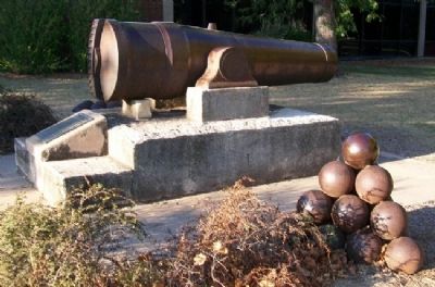
This cannon used in coastal defense during the Civil War was secured through the efforts of Judson Kilpatrick st No. 36, G.A.R. and Congressman Chester I. Long. Presented to Mayor George W. Young for City of Newton by Hon. J. G. Wood, Topeka, on . . . — — Map (db m56919) HM WM
Dedicated in F. C. & L.
to the Union
Soldiers & Sailors
of the War
1861 - 1865
Erected May 30, 1913
Civil War Cannon Replica
Dedicated Dec. 7, 1976
by
Holton National Guard
V.F.W. & Amer. Leg.
Courtesy of
Denison & KS . . . — — Map (db m63876) WM
A band of Confederate guerrillas led by William Quantrill corraled the residents of Shawneetown into the square at this site. A majority of the town's buildings and homes were looted and set on fire nearly destroying the town. Thirteen persons were . . . — — Map (db m20512) HM
The Flag they fought for
(American Flag)
To the memory of
our Unknown Dead
they sleep
on southern battlefields
and 'neath the ocean wave — — Map (db m21316) HM
In Honor of
the Veterans of the Civil War
1861-1865, the Spanish-American War
1898, Our Country's Defend-
ers in the World War 1917-1918
and the Loyal Women of
SpringHill and Community. — — Map (db m21684) HM
In Spring, 1862, William Clarke Quantrill, confederate guerrilla, led raids in and about Aubry, taking an uncounted toll of lives and property. Union troops seeking the raiders camped often along the military road (now Metcalf) from Fort . . . — — Map (db m64012) HM
This point overlooks the historic Neosho Crossing for "The Old Indian Trail" between Missouri and the Osage buffalo hunting grounds in central Oklahoma. The ford was located about eighty yards above the present dam. Two hundred Union soldiers of . . . — — Map (db m96922) HM
The earliest permanent white settler in present Labette County is believed to have been John Mathews, trader and blacksmith, who arrived here about 1840. He established a post to trade with the Osage Indians of one of White Hair's villages, . . . — — Map (db m96965) HM
Four score and seven years ago our fathers brought forth on this continent, a new nation, conceived in Liberty, and dedicated to the proposition that all men are created equal.
Now we are engaged in a great civil war, testing whether that . . . — — Map (db m114216) HM
Colonel 9th Cavalry
Brevet Major General, U.S.A.
Born in Bangor, Me.
Dec. 22, 1832
Died at Fort Robinson, Neb.
April 11, 1889
[Battles]
Brill's Point • Charleston • Sykeston
New Madrid • Point Pleasant • Island No. 10 . . . — — Map (db m42071) WM
Established in 1827, Fort Leavenworth is the oldest army post in continuous operation west of the Missouri River. Serving as the army's chief base of operations on the Central Plains, the fort furnished troops and supplies for military operations . . . — — Map (db m63183) HM
This National Cemetery
has been listed in
The National Register
of
Historic Places
by the
United States Department of the Interior
1999 — — Map (db m42059) HM
During the Civil War, Fort Leavenworth functioned as an arsenal, a supply base, and a training and organizational camp for volunteer troops. A series of defensive earthworks was constructed on a hill overlooking the National Cemetery. The position . . . — — Map (db m63168) HM
In October of 1864 when Fort Leavenworth and the city of Leavenworth were threatened by Confederate forces under General Sterling Price, fortifications were constructed on the crest of the ridge to the west. These works were armed with heavy siege . . . — — Map (db m66684) HM
[Battles listed chronologically]
Palo Alto : Resaca de la Palma : Monterey : Cerro Gordo : Contreras : San Antonio : Cherubusco : Vera Cruz : Molino del Rey : Chapultepec : City of Mexico
Belmont ∙ Fort Henry ∙ Fort Donelson . . . — — Map (db m81734) WM
He helped make Kansas a free state,
He fought to save the Union,
He published the Daily Times for nearly
forty years in the interest of Leavenworth,
He was no hypocrite. — — Map (db m77150) HM WM
The law firm of Sherman, Ewing and McCook was on the 2nd floor of a wooden building located in front of this pedestal. All four partners in the firm became general officers in the Union Army during the Civil War. The most famous member of the firm . . . — — Map (db m42154) HM
William Tecumseh Sherman
Thomas Ewing Jr.
Hugh Boyle Ewing
Daniel McCook Jr.
All four members of the law firm served with distinction as general officers in the Union Army in the Civil War.
Thomas Ewing Jr. was the first Chief Justice . . . — — Map (db m42111) HM WM
Leavenworth's Stockton Hall was built in 1857 at the southwest corner of Fourth and Delaware streets. Although not the first of the town's public halls, Stockton was to become the most famous. It was a frame building forty-five by one hundred and . . . — — Map (db m46716) HM
Daniel Read Anthony, born on February 15, 1820 and his sister, Susan Brownell Anthony, born on August 22, 1824, had tremendous influence over the course of events in Kansas and the nation. Daniel's influence was felt through his newspaper and Susan . . . — — Map (db m42150) HM
This unique chapel was built in 1893. Architect Louis Curtis[s] of Kansas City designed the structure after an old gothic chapel he had seen in England.
It has served veterans of all wars from the Mexican War (1848) on. The beautiful stained . . . — — Map (db m50912) HM
[North Face]
In honor of the Veterans of the
Civil War 1861-1865
[East Face]
In honor of the Soldiers, Sailors
and Marines who served in the
World War 1917-1918
[South Face]
In honor of the Loyal Women
of . . . — — Map (db m34551) HM
Original cabin/fort built in 1855 five miles west of Mound City. The original building was the second cabin owned by James Montgomery as the first one was burned by proslavery Missouri Border Ruffians.
The logs were placed vertically on the . . . — — Map (db m93375) HM
In memory of the
officers and soldiers
buried within this cemetery
who gave their lives
in defence of the Union.
limestone marker
National Cemetery Plot
In 1865 National Cemetery Plot No. 1 was laid out by the . . . — — Map (db m21798) HM
The Lathrop family lived in a cabin south of the creek. They were home during the battle.
"In front of a log cabin stood an old woman, with several children clinging to her skirts, fearless of the leaden shower which ceaselessly pattered . . . — — Map (db m78619) HM
Nearby homes were converted into makeshift hospitals where wounded were treated before being sent to larger hospitals in Mound City, Fort Scott, and Fort Leavenworth. Union soldiers killed in battle were buried in cemeteries within these same . . . — — Map (db m67435) HM
Upon this rolling prairie and across Mine Creek occurred the largest Civil War battle in Kansas. It also was one of the largest cavalry battles of the Civil War. Nearly 8,000 Confederate soldiers clashed with 2,500 Union troops. The battle lasted . . . — — Map (db m20261) HM
Of the approximately 600 Confederate casualties in this battle, many of those killed in action were buried in unmarked graves on this battlefield.
Most of the dead were from Marmaduke's Missouri Cavalry Division and Fagan's Arkansas Cavalry . . . — — Map (db m20264) HM
In October, 1864, a Confederate army under Gen. Stirling Price was defeated near Kansas City. He retreated south, crossed into Kansas, and camped at Trading Post. Early on the morning of October 25 Union troops under Generals Pleasonton, Blunt and . . . — — Map (db m6937) HM
The battle at Mine Creek was one of the largest cavalry battles of the Civil War. Thousands of men and horses took part in the engagement.
Cavalry regiments played an important role. In the beginning they supported the infantry and . . . — — Map (db m78168) HM
Throughout the war a variety of horses were used by both sides. Morgans, American Saddlebreds, Thoroughbreds, Standardbreds, and Quarter Horses are only a few. The ideal horse was a mare or a gelding, aged four or five years, with a height of 56 . . . — — Map (db m78166) HM
At the creek at 11 a.m. on October 25, 1864, the four-to-five feet high banks were slippery and crumbling from a recent rain. The rushing water was deep, and the crossing was difficult. Hundreds of wagon wheels and horses had churned the mud into . . . — — Map (db m78620) HM
When Major General Sterling Price commenced his invasion of Missouri he had several objectives. By the time he reached Indian Territory (present-day Oklahoma) in November, not a single objective had been met. He failed to take St. Louis and . . . — — Map (db m78160) HM
Although the Confederates greatly outnumbered the Union troops at Mine Creek, the Union army clearly had an advantage with its weapons. The Confederates were armed with long muzzle-loading infantry rifles, which were difficult to reload on . . . — — Map (db m67409) HM
Dedicated to the memory of those who served to preserve the Union during the Civil War, 1861-1865
This bridge was donated and installed to provide access to the main ford of Mine Creek — — Map (db m78188) HM WM
This present day photo of Mine Creek Battlefield with overlays highlights the positions of Union and Confederate troops at 11 a.m. on October 25, 1864. Note where you are positioned in relationship to the events of that day.
The woods and farm . . . — — Map (db m67380) HM
When the armies moved south, hundreds of dead and wounded men were left behind on the battlefield. As soon as the shooting stopped civilians from nearby homes offered assistance.
Men "had fallen all about the house and crawled away to fence . . . — — Map (db m78162) HM
One of the largest cavalry battles of the Civil War was fought in the fields around Mine Creek.
In August 1864 Confederate Major General Sterling Price received orders to invade Missouri. He was to bring Missouri into the confederacy and . . . — — Map (db m67398) HM
With two brigades of 2,500 Union cavalrymen bearing down upon them, the Confederate rear guard formed a skirmish line. This maneuver delayed Union troops long enough for the Confederates to establish a main line of defense 800 yards south. The . . . — — Map (db m67408) HM
The Fort Scott Road ran in a north/south direction just east of the fence line. As it approached Mine Creek it veered to the southwest. This road paralled the route of present-day U.S. 69 Highway. Because this was a "running" engagement, the road . . . — — Map (db m50161) HM
Captain Richard Hinton was with the Union soldiers as they approached from the north. As the "timber of Mine Creek" came into view, Hinton wrote,
the enemy were discovered in great force formed in line of battle upon the north side of the . . . — — Map (db m50170) HM
When the Union charge commenced the 10th Missouri Cavalry, USA, started forward with a yell and bugles blaring, but half-way down the slope the men hesitated and stopped when the Confederates showed no sign of breaking.
Union Lieutenant . . . — — Map (db m67445) HM
(Front):
Rev. B. L. Read
John F. Campbell
William Colpetzer
Michael Robertson
Patrick Ross
William Hairgrove
Asa Hairgrove
Charles Snider
William A Stilwell
Amos Hall
Austin Hall
(Side 2):
On the 19th day of May . . . — — Map (db m20113) HM
The Frontier Military Road was used to provide soldiers and supplies to the forts along the "Permanent Indian Frontier". Fort Leavenworth and Fort Scott were on the route in what is now eastern Kansas. The only major Civil War Battle in Kansas was . . . — — Map (db m33940) HM
Pro- and anti-slavery forces made their way to this area on horseback and on foot in the fight over whether Kansas would be a free state or a slave state. Skirmishes, scuffles and screams could be heard in the woodlands nearby.
The Marias des . . . — — Map (db m33944) HM
In memory of the
Defenders of the Union
1861-1865
————————
In 1900 the Peabody Women's Relief Corps Post 99, auxiliary for Peabody Post 89 of the Grand Army of the Republic, purchased this . . . — — Map (db m95252) HM WM
An acknowledgement of the debt which mankind owes to the Heroes who fought to maintain our national union, and preserve to the world a government founded upon liberty and equality. — — Map (db m78050) WM
In Sacred Memory
of
Our Heroes
This monument was erected by the American Legion Auxiliary of Meade, Kansas, assisted by ex-service men and patriotic citizens, and on May 30, 1927 dedicated to the memory of Meade County's Departed . . . — — Map (db m65636) WM
On the morning of August 30, 1856, John Brown led about 30 antislavery men into battle against 250 proslavery Missourians. This Battle of Osawatomie raged on the site of John Brown Memorial Park.
Local tradition maintains that the statue of . . . — — Map (db m21125) HM
Purchased by Department of Kansas
Womans Relief Corps
Dedicated to the
Grand Army of the Republic
Presented to the State of Kansas
for a memorial park — — Map (db m69244) WM
Dedicated to a couple who helped found and shape Paola, Baptiste Peoria, chief of the Confederated Peoria Tribes and his wife Mary Ann Isaacs Dagenet Peoria chose to take a leadership role in developing Paola. Most of the Paola Town Company were . . . — — Map (db m34428) HM
Near this monument March 8, 1862, Captain Richard C. Mason of the 16th Arkansas Cavalry and was severly wounded and his horse killed. Mason was rescued by Frank Colbert a Chickasaw. Mason served for the duration of the war, and received an honorable . . . — — Map (db m57880) HM WM
Erected to the memory of the
Union Soldiers and Sailors
of the Civil War
Dedicated in memory of the
U.S. Armed Forces
of the War with Spain
Dedicated in memory of the
U.S. Armed Forces of
World War I
Dedicated in memory of . . . — — Map (db m53055) HM
During the Civil War, militias from both the Union and Confederate sides were stealing the Osages' cattle, harassing their villages, and blaming the Indians for raids actually committed by Americans. Osage leader Charles Mongrain cautioned everyone . . . — — Map (db m60477) HM
In memory of the
Soldiers and Sailors
of the War of
1861 - 1865
Erected May 30, 1907
under the auspices of
Erie Post No. 311
Department of Kansas
G.A.R. — — Map (db m46227) WM
The Oak Grove School was built facing the only road that existed here in 1877 — the Osage Trail. Prior to 1865, the Neosho River valley (including the site where you now stand) was part of the Osage Reservation. At one time a large Osage village . . . — — Map (db m229750) HM
Seventh Kansas Cavalry
Died, August 22, 1864
Abbeville, Mississippi
In 1876 the Kansas Legislature name Ness County in his honor. This statue is in memory of Noah Ness and all the brave men who have fought to keep this country free. . . . — — Map (db m66143) WM
In Memory of Our
Patriot Dead
We here highly resolve
that these dead shall
not have died in vain.
Lincoln.
We loved our country
Gave our lives for her
Do ye, our children
for her honor live.
Sleep in peace with kindred ashes
Of . . . — — Map (db m79925) WM
Established Oct. 22, 1859 and known as Camp on the Pawnee Fork. Name changed to Camp Alert Feb. 1, 1860, and to Fort Larned, June 1, 1860 in honor of Col. B. F. Larned, Paymaster General of the United States Army. Abandoned in 1878, and sold Mar. . . . — — Map (db m95812) HM
Original monument erected in 1867 by soldiers in the Third Infantry, to honor fellow soldiers who lost their lives at the fort. After Fort Larned was closed in 1878, this monument was moved to the Larned [city] Cemetery in 1887. In 2009 it was . . . — — Map (db m40180) HM
In memory of the
Defenders of our Union
1861 - 1865
Dedicated to the
honor and sacrifice of our
men and women
who served our country
in war and peace — — Map (db m53322) HM
United States
Army • 14 June 1775
Navy • 13 October 1775
Marine Corps • 10 November 1775
Coast Guard • 4 August 1790
Air Force • 18 September 1947 — — Map (db m80978) WM
Mary Ann Ball was born near Mount Vernon, Ohio in 1817. She married Robert Bickerdyke in 1847 and they moved to Galesburg, Illinois.
At the outbreak of the Civil War the residents of Galesburg purchased medical supplies worth $500 for soldiers . . . — — Map (db m95499) HM
August Bondi was born July 21, 1831, in Vienna, Austria. The Bondis, Jewish European refugees, fled the Austrian Empire after the failed revolutions of 1848 and settled in St. Louis, Missouri. August Bondi moved to Pottawatomie Creek in Franklin . . . — — Map (db m134060) HM
In 1918 this gateway was erected as a memorial to Civil and Spanish War veterans. The bronze statue on the left is a Union soldier while the one on the right is a Rough Rider. The original gateway was 12 feet apart and included a folding bronze . . . — — Map (db m92188) HM WM
Erected A.D. 1912 by the
People of Sedgwick County, Kansas
in memory of the
Union Soldiers and Sailors
of the Civil War
The Union is perpetual
Abraham Lincoln
Let us have peace
Gen. Grant
If any man attempts to . . . — — Map (db m56422) WM
As secession swept the South, various state banners were created to symbolize the "independence" movement. Soon the Confederacy found it necessary, however, to adopt an appropriate "national" flag. The first was the famous Stars and Bars. During . . . — — Map (db m107792) HM
Between 1818 and 1861 no less than 13 changes were made in the Stars and Stripes as a result of the westward expansion. With the admission of Kansas in 1861, the [S]tars and [S]tripes became a thirty-four star flag. It was this flag that would be . . . — — Map (db m56962) HM
The Corridor of Flags outlines BNSF Railway Plaza leading to the All Veterans Memorial. The unique sculpture represents the flame of liberty, embodying the American ideals of freedom and democracy. It is erected in tribute to the members of . . . — — Map (db m47008) HM
Erected by G. G. Gage
to the memory of
his comrades who fell at
The Battle of the Blue.
Oct. 22, 1864.
By the blood of these heroes, and
their compatriots, this great
Republic was made to live
2nd Regiment K. S. M.
from . . . — — Map (db m47339) HM