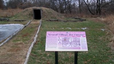
Independence Creek was noted as the main settlement of the Kanza Tribe as far back as 1673. By the time French explorer Etienne Veniard de Bourgmont arrived in 1724 this was considered an old village and the capital of the Kanza nation.
This . . . — — Map (db m52993) HM
As early as the 1600s, the Kanza (or Kaw) Indians migrated from their home east of the Mississippi River and up the Missouri River into what is now northeastern Kansas. In the 1700s, the Kanza occupied two villages on the west bank of the Missouri: . . . — — Map (db m44816) HM
In 1804-06, Captains Meriwether Lewis and William Clark led about 40 soldiers and boatmen on an epic journey. President Thomas Jefferson commissioned this "Corps of Discovery" to find a route to the Pacific Ocean through the newly acquired . . . — — Map (db m44807) HM
At Medicine Lodge Creek in 1867, as many as 15,000 Apaches, Kiowas, Comanches, Arapahos, and Cheyennes gathered with a seven-member peace commission escorted by U.S. soldiers to conduct one of the nation’s largest peace councils. The American . . . — — Map (db m65195) HM
To commemorate the signing of the peace treaties between the United States Government and the Five Tribes of Plains Indians at Medicine Lodge, Kans.
Oct. 21-28, 1867. — — Map (db m65128) HM
For thousands of years, Native Americans relied on this region's wildlife for sustenance. Early settlers, too, depended on bison, deer, and birds drawn to the region's reliable water and forage.
As settlements expanded, unregulated hunting . . . — — Map (db m95699) HM
No one actually knows how Pawnee Rock was named. Josiah Gregg, who had been over the Santa Fe Trail eight times beginning in 1831, wrote: the attention of the traveller is directed to the ‘Pawnee Rock' so called, it is said, on account of a . . . — — Map (db m64243) HM
In honor of the brave men and women
who passing over the old Santa Fe Trail,
endured the hardships of frontier life,
and blazed the path of civilization for posterity
Pawnee Rock, given to the State of Kansas
by Benj. P. Unruh,
in . . . — — Map (db m64248) HM
"The commands are given, the companies break into column....hardy, dashing looking fellows, those men, tanned up in their march from Fort Scott, from whence they have just joined us....The men are nearly all quite young....They are mounted on . . . — — Map (db m36137) HM
Fort Scott tells America's story during a critical time in its growth. When the fort was established, most of the nation's population lived east of the Mississippi. However, soon soldiers from Fort Scott would be part of westward . . . — — Map (db m128757) HM
"Every military post shall have one Sutler, to be appointed by the Secretary of War."
General Regulations for the Army of the United States, 1841
About 100 yards in front of you an engraved stone marks the location of Fort . . . — — Map (db m128685) HM
You have arrived at the only unit in the National Park Service dedicated to the tallgrass prairie ecosystem. Tallgrass prairie once covered a vast region that stretched from Mexico into Canada. Today, only a small fraction - perhaps less than four . . . — — Map (db m49499) HM
Opened in 1803 by Chief Black Dog (Manka-Chonka) and his band of Osage Indians who had a village nearby where springs once flowed freely. — — Map (db m37839) HM
The Osage at Baxter Springs
The Osage once controlled a vast territory in the center of North America. In the mid-1600s, the tribe moved to the area around Baxter Springs. The area was important to the Osage because, for the tribe, it was . . . — — Map (db m174252) HM
The Cherokee Indians were given this land in an 1835 treaty becoming the Cherokee Neutral Lands. Kansas was established as a state in 1861. The territory became Cherokee County named for the Cherokee Indian Nation.
During the Civil War the . . . — — Map (db m60770) HM
Formerly, modern-day Galena was a wooded area of the Kansas
Ozarks. By 1835, it was part of the Cherokee Neutral Lands, though
Euro-Americans quickly settled the region after Kansas became a state
in 1861. Sharing a border with slave-state . . . — — Map (db m161630) HM
Headquartered in Fort Scott, Union Major General James G. Blunt was the highly recognized commander of the District of the Frontier. In 1863, Blunt decided his force needed to be closer to the gathering Confederate forces in the South and headed out . . . — — Map (db m170743) HM
The people of the Cherokee Nation left a lasting legacy to this corner of the State.
The 1836 Treaty of New Echota forced the removal of the Cherokee Nation from lands east of the Mississippi to the new Indian Territory. In addition to the . . . — — Map (db m81141) HM
You stand just miles north of one of Kansas' oldest highways: the Black Dog Hunting Trail.
In order to provide a supply route between seasonal hunting grounds, the indigenous people of the Osage Nation blazed a trail in the first decade of . . . — — Map (db m81145) HM
From wagon trails to rivers, railroads to highways, the ease of transporting people and goods has shaped the settlement of Kansas. At Riverton, two paths from different eras, now Historic Byways, cross. The Old Military Road passes along Kansas' . . . — — Map (db m170681) HM
These iron sculptures by Todie Zweygardt are in memory of the Cheyenne and other Indians, survivors of the 29 Nov. 1864 Massacre at Sand Creek, Colo., who fled to this Cherry Creek Valley, remaining until joined by forces of there Plains tribes for . . . — — Map (db m78887) HM
Born in the tribal town, Tuckabatchee, Alabama, in the late 1700s, Upper Creek Leader Opothleyahola demonstrated leadership as a youth, was later cited by three Presidents for his enduring struggle to win freedom for his people. Forced from . . . — — Map (db m80037) HM
Dedicated to
the many thousands who pioneered
The Cherokee Strip
September 16, 1893
Thousands gathered in this area to start a
new frontier, six million acres of Cherokee
Indian land was opened to homesteaders.
Tension, danger . . . — — Map (db m60486) HM
After the 1876 Battle of Little Big Horn in Montana, tensions mounted between the U.S. government and the Plains Indians. The U.S. army intensified efforts to remove the Northern Cheyennes to Indian Territory (Oklahoma) in 1877. There the tribe . . . — — Map (db m152717) HM
In 1540 Francisco Vasquez de Coronado marched north from Mexico with 300 Spaniards in search of the "Seven Golden Cities of Cibola." With them were several priests, including Juan de Padilla, a Franciscan friar. When the golden cities proved to be . . . — — Map (db m49674) HM
The Oregon-California Trail passed by the mission and trail ruts are still visible to the southeast of the building. Both tribes benefitted from the increased traffic by building a toll bridge. But with the travelers came small pox and cholera, . . . — — Map (db m47926) HM
On average, 40 students lived at the mission. Irvin wrote, "Our custom is to rise at five o'clock in the morning, breakfast at six, have six hours at school in the day, commencing at nine, and the hours out of school are spent at work." Lessons . . . — — Map (db m47925) HM
The Presbyterian Board of Missions sent the Reverend Samuel M. Irvin to this area to establish an agricultural mission for the Iowa and Sac & Fox, who survived by hunting. Irvin tried to teach them to farm and raise livestock but had little . . . — — Map (db m47923) HM
Many diaries of travelers on the Oregon-California Trail speak of good relations with Native Americans. Indians helped travelers by delivering their letters, pulling their wagons up steep banks, teaching them about edible plants, and keeping watch . . . — — Map (db m47956) HM
As the nation pushed west, Indian tribes were removed from their lands. Between 1825 and 1850, 25 tribes were relocated to Kansas. Two tiny strips of land in extreme northeast Kansas were set aside for the Iowa and the Sac & Fox. Relocation meant . . . — — Map (db m47903) HM
The hand-hewn bricks in this memorial were taken from the fireplace of Rubeti Lodge. Constructed as a home for Indian girls, Rubeti Lodge was erected as a memorial to Sophie Rubeti, a young girl of the Sac Indian tribe. Sophie lived at the mission . . . — — Map (db m47797) HM
The passage of the Kansas-Nebraska Act in 1854 further reduced the size of Indian reservations. Too far removed from the tribes, the mission closed in 1863. Today both tribes have reservations in Kansas, Nebraska, and Oklahoma. The Sac & Fox also . . . — — Map (db m47928) HM
In 1845 the missions board began construction of a building to house and educate the children of the Iowa and Sac & Fox tribes. Much larger than it is now, the mission was originally 106 feet long and contained 32 rooms, including a dining hall and . . . — — Map (db m47924) HM
The Iowa, Sac and Fox Mission was one of many Indian missions built in what is now Kansas between 1820 and 1862. Established in 1837 by Reverend Samuel and Eliza Irvin and Reverend William and Julia Hamilton, the mission was sponsored by the . . . — — Map (db m121796) HM
While some wanted to "Americanize" the relocated Indian tribes, others wanted to offer aid. Missionaries set up schools to convert the Indian children to Christianity and to teach them vocational skills. Many Indians preferred to maintain their own . . . — — Map (db m47907) HM
From the early 1840s to 1865 the Oregon-California Trail was the most important route for settlers traveling west. Wagon trains camped at the Iowa, Sac and Fox Mission to take advantage of the spring and the blacksmith. They were followed in the . . . — — Map (db m47930) HM
Before reaching the Iowa, Sac and Fox Mission wagon trains crossed the Wolf River. Travelers often encountered members of local Indian nations. Native Americans thought that some payment should be made to them for the use of their land. Travelers . . . — — Map (db m47947) HM
A History
David Sheppard and Dean O'Bannon found 'Tall Oak' in Rushville, Mo. The tree was donated to the Doniphan County Chamber of Commerce by Mr. and Mrs. David McDevitt. The name "Tall Oak" was given to the tree by Sherry Muse, 3rd grade . . . — — Map (db m47715) HM
As early as the 1600s, the Kanza (or Kaw) Indians migrated from their home east of the Mississippi River and up the Missouri River into what is now northeastern Kansas. In the 1700s, the Kanza occupied two villages on the west bank of the Missouri: . . . — — Map (db m55930) HM
In 1804-06, Captains Meriwether Lewis and William Clark led about 40 soldiers and boatmen on an epic journey. President Thomas Jefferson commissioned this "Corps of Discovery" to find a route to the Pacific Ocean through the newly acquired . . . — — Map (db m55928) HM
The current City Hall building was completed in 1955. The first City Hall, which was originally built as a school house in 1860, was also situated at this location until it was moved to 731 Maple Street. The community of Eudora was established in . . . — — Map (db m76484) HM
This residence likely dates to the 1860's. James Still, son of Wakarusa Mission (which served the local Shawnee Indians in the 1850's) founder Abraham Still, had his medical office here. In addition to being a doctor, James Still was also a . . . — — Map (db m76490) HM
Shawnee Tribal Leader Paschal Fish and his daughter, Eudora
This statue has been created to commemorate the 150th anniversary of the City of Eudora (1857-2007). The statue portrays Shawnee Tribal Leader Paschal Fish and his daughter, . . . — — Map (db m239853) HM
Coffin Sports Complex was built in 1981. It has an Olympic-size swimming pool, racket ball courts and basketball court. It currently is the home for the American Indian Athletics Hall of Fame. Coffin Complex is named after Tony Coffin, . . . — — Map (db m77301) HM
The Haskell Bandstand, (now called the Gazebo) was built in 1908 after the previous bandstand was destroyed by a wind storm. Music was an enjoyed student activity. The bandstand was used frequently for concerts in the early days. The bandstand is . . . — — Map (db m77382) HM
During the weekend of October 27th to 30th, 1926, Haskell Institute hosted a celebration and dedication to the newly constructed football stadium and Arch. (Donations for the construction of the stadium came from all over Indian Country. Haskell . . . — — Map (db m77303) HM
Haskell Institute circa 1903
The road going into the Haskell grounds, from the left side of picture, is the current Barker Ave. The buildings from left to right are: Hiawatha, Superintendent’s house, Osceola, Sequoyah (far background . . . — — Map (db m77318) HM
This project is dedicated to those who were here first.
Haskell Indian Nations University campus is a unique and special place. Please, respect these grounds and buildings as you walk around campus.
From 1884-1890, the school’s official . . . — — Map (db m77379) HM
The first three buildings on the Haskell grounds are from left to right: Osceola (boy’s dorm), Sequoyah (the schoolroom), Keokuk (girl’s dorm).
Location of the original three buildings, overlaid on top of current building locations. The yellow . . . — — Map (db m77383) HM
Haskell’s destiny in becoming a four-year university for native students has a history to be preserved and shared.
In 1890, Haskell Institute became the official name. Several years passed before classes were offered beyond the . . . — — Map (db m77381) HM
In Honor of the 415
“Haskell Warriors”
that served in
World War I
and in memory of
those ‘Warriors’
who made the
supreme sacrifice
for their country.
Rededicated
October 13, 2001.
75th Anniversary
The . . . — — Map (db m77316) WM
Hiawatha was a legendary Native American leader and co-founder of the Iroquois Confederacy. Depending on the version of the narrative, Hiawatha lived in the 16th century and was a leader of the Onondaga in the New York area. Hiawatha was a . . . — — Map (db m77384) HM
Between Lawrence and Topeka, the Kansas turnpike passes near the route of the old Oregon-California Trail, traveled in the 1800s by explorers, missionaries, soldiers, emigrants in search of land, and forty-niners in search of gold. Fifteen miles . . . — — Map (db m103242) HM
Tecumseh Hall was built in 1915 for use as the boys' gymnasium. Today, the first floor has a basketball court and is, also, used for other campus activities and events.
The Indian Leader newspaper and Student Activity offices are located in . . . — — Map (db m77305) HM
The Haskell Cemetery has approximately 100 students buried here. The child’s name, tribal affiliation, date of birth and death are engraved on their headstone. Some of causes of death were listed as consumption (Tuberculosis), pneumonia, . . . — — Map (db m77300) HM
The Original Bandstand was located approximately in this area between the old Winona and Osceola Halls. It was destroyed in a wind storm in 1906 or 1907. — — Map (db m77325) HM
[American Indian woman sculpture with eagle feathers attached to United States Armed Forces emblem medallions as well as service emblems on wall behind sculpture] — — Map (db m77567) WM
As settlement increased in the West during the 1850s and 1860s, the U.S. Army built and maintained a series of frontier forts, usually on major transportation routes. Trail traffic and railroad expansion came into conflict with native people who . . . — — Map (db m59794) HM
Herds of 60 million buffalo once roamed the prairie until reduced to 300 and near extinction. They were the basis of Indian economy; food for the emigrant, railroad worker and soldier. — — Map (db m59713) HM
The rolling land in this area was once sheep country, but now cattle roam here. These stone fence posts found are examples of the many still in use in this portion of Kansas. In an area where wood for posts was scarce, settlers used the materials at . . . — — Map (db m88765) HM
For thousands of years American Indians depended upon the buffalo for food, materials for shelter, and numerous other necessities. This relationship ended toward the end of the 19th century when commercial hide hunters nearly drove the buffalo to . . . — — Map (db m213864) HM
"Long ago the Arapahoes had a fine country of their own. The white man came to see them, and the Indians gave him buffalo meat and a horse to ride on…the country was big enough for the white man and the Arapahoes, too…The government sent . . . — — Map (db m65508) HM
Eighteen Miles a Day
Hundreds of freight wagons laden with trade items once lumbered by here, passing just uphill from where you are standing. Large caravans took six to ten weeks to travel the 900 miles between Mexico (present-day New . . . — — Map (db m65512) HM
About two miles west were the Lower Springs of the Cimarron River, known today as Wagon Bed Springs. For early-day travelers on the famous Santa Fe Trail, the springs were an “oasis” in dry weather. Several shortcuts of the trail converged here, . . . — — Map (db m213735) HM
The Kansa Indians (Kaw) came to this region from the forested southeast. They lived in permanent longhouses covered with bark and cultivated corn, beans, and squash. In their western hunting grounds they captured buffalo and other large animals. . . . — — Map (db m63719) HM
Twenty-eight settlers, organized as the Buffalo Militia, built Fort Jewell following the killing of three white men at the milldam on the Solomon River. Sod was used for fort walls, which were four feet thick, seven feet high, enclosing a space . . . — — Map (db m176765) HM
From the late 1820s to the 1870s, an estimated 300,000 fur traders, missionaries, settlers, and gold seekers followed these trails. In the 1840s and 1850s, emigrants from the eastern and central United States walked 2,000 miles from the Missouri . . . — — Map (db m131376) HM
The Indian Removal Act of 1830 required that many American Indian Tribes in the eastern part of the United States be moved to the Great Plains Region west of the Missouri River — lands identified as the “Permanent Indian Frontier.” . . . — — Map (db m131313) HM
"We took the Oregon road, instead of that to Santa Fe and went twelve miles before we discovered our error. In returning two of our wagons broke down, by which we were detained two days until July 4th. We at last got fairly on the Santa Fe . . . — — Map (db m131312) HM
Travel along the Oregon and California trails increased in the 1840s with the cry of “Westward Ho.” When the 1848 discovery of gold was made at Sutter’s Mill in California, the desire to reach the gold fields ahead of others intensified . . . — — Map (db m131310) HM
Religious missionaries of nearly all denominations were present throughout Indian settlements as early as the 1680’s. Missionaries were intent on converting the Native Americans to Christianity. Quakers (The Society of Friends) had worked among the . . . — — Map (db m46855) HM
In 1825 the Federal government began moving Eastern Indians to new lands west of the Mississippi. This sign is on a 2,500 square mile tract assigned to the Shawnees.
With this tribe came Methodist, Baptist and Quaker missionaries. One mile east . . . — — Map (db m20906) HM
From the late 1600’s until the early 1800’s, the Kansa (or Kaw) Indians lived in northeast Kansas. The Indian word Kansa means “People of the South Wind,” and both the state of Kansas and the Kansas River take their name from this . . . — — Map (db m46854) HM
- Main Marker: -
Founded in 1857, Olathe was strategically located on the Santa Fe Trail. In the era of horsepower, the new town was a day's journey from Independence, Missouri. As time passed, Olathe's population and commerce grew, and . . . — — Map (db m20270) HM
According to the agricultural census of that year, Beatty Mahaffie produced 2000 bushels of corn on this farm in 1865. The average Johnson County farm produced 667 bushels. This small field is slightly less than one acre in size. With forty bushels . . . — — Map (db m34460) HM
The Trip Ahead
The Santa Fe, Oregon, and California trails proved to be both challenging and exhilarating for the travelers in the caravans passing near here. Letters and diaries are filled with the adventures, excitement, and hardships . . . — — Map (db m99328) HM
The heritage of Johnson County, Kansas extends back to the native peoples who occupied this land prior to European exploration and settlement. In the 1700s, French explorers, trappers and traders engaged with the Kansa and Osage natives of this . . . — — Map (db m226610) HM
In the spring of 1816 Auguste P. Chouteau's hunting party traveling east with a winter's catch of furs was attacked near the Arkansas river by 200 Pawnees. Retreating to what was once an island five miles southwest of this marker the hunters . . . — — Map (db m65747) HM
Before this became a great agricultural country its most important product was the buffalo. Millions of these animals grazed over the prairies, moving in great herds that stretched from horizon to horizon. They were life itself to the Plains . . . — — Map (db m62657) HM
Early Days
This bluff on which the Riverside Park sits is steeped in history. Towering over the plains, this site was frequented by both American Indians and early Euro-American settlers. It served as a place to observe game and also for . . . — — Map (db m96902) HM
This old well is whiteman's improvement to an everlasting spring used by the Indian tribes for ages
and marks the first known white settlement in southern Kansas.
John Mathews settled here to serve as blacksmith for the Osages about 1841 and . . . — — Map (db m96966) HM
Depicting when the Osage dwelled east of the bluff near Horseshoe Lake and Chief White Hair was their Chief. John Mathews, a fur trader and blacksmith, lived on the summit, intermingling with the tribe, both cultures benefiting from the . . . — — Map (db m42284) HM
This point overlooks the historic Neosho Crossing for "The Old Indian Trail" between Missouri and the Osage buffalo hunting grounds in central Oklahoma. The ford was located about eighty yards above the present dam. Two hundred Union soldiers of . . . — — Map (db m96922) HM
The earliest permanent white settler in present Labette County is believed to have been John Mathews, trader and blacksmith, who arrived here about 1840. He established a post to trade with the Osage Indians of one of White Hair's villages, . . . — — Map (db m96965) HM
Pittsburgh, PA
Buried - Jacksonville, IL
Married Alice Kirk - 24 Sep 1854
Married Lillian King - 28 Jul 1897
Fathered seven children
29 years of military service
1861 - 1890
Advocated equal treatment for Blacks and Native Americans . . . — — Map (db m65043) HM WM
This memorial is dedicated to:
"Quah-Kah-Ka-Num-Ad"
Potawatomie for
"Woman Who Prays Always".
Rose Philippine Duchesne was a nun of the
Society of the Sacred Heart of Jesus,
a teaching order.
She taught Indian children here in . . . — — Map (db m70633) HM
The removal of the Potawatomi Indians from northern Indiana to Kansas took place Sept. - Nov. 1838. Nearly 900 Indians were rounded up by soldiers and marched at gun point for 61 days. So many died on the way and were buried by the roadside that . . . — — Map (db m70609) HM
This granite depiction of St. Philippine and two American Indians is an enlarged copy of a 3" x 5" sketch done by an unknown nun of St. Charles, Mo. Lawrence Branstetter of Bruce Marble in Fort Scott copied and enlarged the design using a . . . — — Map (db m70656) HM
Rev. Benjamin Marie Petit, of the City of Rennes, France, arrived as the Catholic missionary to the Potawatomi Indians in northern Indiana in November 1837. By June 1838, he had learned much of their difficult language and their culture, and had . . . — — Map (db m70652) HM
Father Benjamin Marie Petit, a missionary to the Potawatomi in northern Indiana, accompanied them on the forced removal in 1838. He ministered to their needs, both spiritual and physical. He baptized the dying children, "whose first step was . . . — — Map (db m70635) HM
The rock lined pits in this area pre-date the arrival of the Potawatomi Indians. Theories are that they may have been used for seed or food storage. The rocks here are shaped differently than any other in the area and their origin is uncertain. . . . — — Map (db m70575) HM
On this site a log cabin with stone foundation was built for St. Philippine Duchesne and two other nuns. The work was done by the Pottawatomie Indians under the directions of black master carpenter Edmund who had accompanied the nuns to Kansas from . . . — — Map (db m70640) HM
[Map] Designates 1838 'Trail of Death' route from Indiana to present day Osawatomie, Kans.
In September 1838 over 850 Potawatomi Indian people were rounded up and marched at gunpoint from their Indiana homeland. Many walked the 600-mile . . . — — Map (db m70654) HM