On 7th Street Northwest at F Street Northwest, on the right when traveling south on 7th Street Northwest.
[Inscription on Monument's front, 1890]:
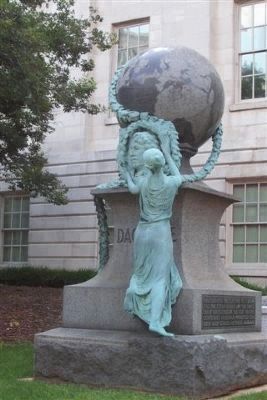
DAGUERRE
[Inscription on 1890 monument's south side]:
To commemorate the half century in photography 1839 - 1889. Erected by the photographers association of America Aug. 1890. . . . — — Map (db m28545) HM
On 7th Street Northwest at F Street Northwest, on the right when traveling south on 7th Street Northwest.
This monument pays tribute to French Artist and inventor Louis-Jacques-Mandé Daguerre (1787–1851), who revolutionized picture-making in 1839 by introducing the first practical form of photography to the world. Known as the daguerreotype, Daguerre's . . . — — Map (db m80876) HM
On Bryant Street Northwest east of 6th Street Northwest, on the left when traveling east.
During the Civil War (1861-1865), thousands of formerly enslaved people came to Washington in search of new lives. They needed work, education, shelter – and health care. In 1862 the U.S. government responded with Freedmen’s Hospital, located . . . — — Map (db m130764) HM
Near College Street Northwest east of 6th Street Northwest, on the right when traveling west.
In Recognition of
Sara Winifred Brown, M.D.
Her medical degree was awarded by Howard University in 1904. She served as the first female graduate trustee of Howard University, 1924-1948.
In 1910, she was one of the founders of the . . . — — Map (db m112010) HM
On Rhode Island Avenue Northwest (U.S. 29) at 10th Street Northwest, on the right when traveling west on Rhode Island Avenue Northwest.
Benjamin Banneker was born to free parents on November 9, 1731, in Baltimore County, Maryland and spent his childhood on his family's farm. His grandmother taught him to read and write. He later attended a one-room school. Banneker worked a . . . — — Map (db m211190) HM
The Residence Act of 1790 established a 10-mile square along the Potomac River as the permanent seat of the United States government. President George Washington was authorized to select the site and appoint a commission to oversee the planning . . . — — Map (db m211191) HM
On Rhode Island Avenue Northwest (U.S. 29) at 10th Street Northwest, on the right when traveling west on Rhode Island Avenue Northwest.
The city blocks occupied by today's Benjamin Banneker Academic High School trace their origins to the earliest plans for the nation's capital. Although the surrounding streets appear on the first maps drawn in 1791, the area was sparsely . . . — — Map (db m211192) HM
On Rhode Island Avenue Northwest (U.S. 29) at 10th Street Northwest, on the right when traveling west on Rhode Island Avenue Northwest.
The Almanac of 1792
Almanacs were among the most popular publications in 18th century America. Almanacs consisted of an ephemeris, a mathematical table predicting the position of celestial bodies during the course of a year, along with . . . — — Map (db m211187) HM
On Rhode Island Avenue Northwest (U.S. 29) at 10th Street Northwest, on the right when traveling west on Rhode Island Avenue Northwest.
Banneker's curiosity about the stars was piqued after peering through a telescope owned by George Ellicott. Ellicott encouraged Banneker's exploration of astronomy, lending him several books and instruments. Banneker successfully calculated a . . . — — Map (db m211189) HM
On Tracy Place Northwest at Kalorama Road Northwest, on the right when traveling west on Tracy Place Northwest.
Sheridan-Kalorama has been home to many influential women. While she lobbied our political leaders to support Nationalist China, Madame Chiang Kai-Shek lived nearby at 2443 Kalorama Rd. Others include presidential wives Eleanor Roosevelt, a wise . . . — — Map (db m112604) HM
On Asia Trail south of Olmsted Walk, on the right when traveling east.
This year, the Smithsonian's National Zoo and Conservation Biology Institute celebrates 50 years of giant panda conservation success. Breeding giant pandas is far more complicated than just bringing two giant pandas together, as early efforts . . . — — Map (db m212329) HM
On Asia Trail south of Olmsted Walk, on the right when traveling east.
Anup Joshi was the station manager for the Smithsonian's Tiger Ecology Project in Nepal in the 1980s.
He has spent countless hours studying how sloth bears and tigers live in the forest. This information will help him suggest new ways to . . . — — Map (db m212328) HM
Near Olmsted Walk, 0.2 miles west of North Road, on the right when traveling west.
Bald eagles were once endangered largely due to DDT, a pesticide that harmed bald eagles' eggs. The banning of DDT along with the passage of the Endangered Species Act helped the bald eagles' numbers to rise, and today our national bird is no longer . . . — — Map (db m184438) HM
Near Olmsted Walk, 0.2 miles west of North Road, on the right when traveling west.
Black-footed Ferret
Black-footed ferrets are the only ferret species in North America. Once thought to be extinct, they were rediscovered in 1981. With the help of the Zoo's conservation efforts and breeding programs, the black-footed . . . — — Map (db m184441) HM
Near Olmsted Walk, 0.4 miles east of Connecticut Avenue Northwest, on the right when traveling east.
Where Pandas Once Lived
Giant pandas once lived across southeast China and in northern Burma and Vietnam.
Giant pandas living in China's lowlands lost their habitat in the 12th century as people moved into the river . . . — — Map (db m184389) HM
Near Olmsted Walk, 0.2 miles west of North Road, on the right when traveling west.
Historic Hatchlings
In 1992, the National Zoo became the first place outside the Komodo dragon's native Indonesia to successfully breed the giant lizard. Since then, four clutches of eggs have hatched at the Zoo, resulting in 55 offspring . . . — — Map (db m184449) HM
Near Olmsted Walk, 0.1 miles east of Connecticut Avenue Northwest, on the left when traveling east.
Going, Going…Coming Back?
The scimitar-horned oryx and the dama gazelle once thrived on the grassy plains spanning northern Africa. But threats such as overhunting, drought, and competition from domestic cattle led to massive losses for . . . — — Map (db m184427) HM
Near Olmsted Walk, 0.2 miles west of North Road, on the right when traveling west.
Maned Wolf
The maned wolf has a unique method of hunting prey. When it hears a small animal moving in the grass, it taps its foot on the ground, startling its prey into running. The wolf then pounces on the exposed animal to catch its meal. . . . — — Map (db m184439) HM
Near Olmsted Walk, 0.1 miles east of Connecticut Avenue Northwest, on the left when traveling east.
What happened to the oryx?
Overhunting and competition from domestic cattle led to the decline of wild scimitar-horned oryx. By 1990, the only remaining oryx were in human care.
Though still considered extinct in the wild, . . . — — Map (db m184425) HM
Breeding Programs
Habitat loss and competition with livestock caused drastic declines in Pzrewalski's horses. Declared extinct in the wild in the 1960s, zoo breeding programs rebuilt populations from 14 individuals.
Successful breeding . . . — — Map (db m111628) HM
On Olmsted Walk, 0.5 miles east of Connecticut Avenue Northwest, on the left when traveling east.
Breeding Programs
Habitat loss and competition with livestock caused drastic declines of Przewalski's horses, and by the 1960s they were declared extinct in the wild. Zoo breeding programs rebuilt wild populations from a mere 14 . . . — — Map (db m184429) HM
Near Olmsted Walk, 0.3 miles west of North Road, on the right when traveling west.
Zoos Are Part of the Plan
In 1982, the Chinese alligator became the first reptile to be managed by an AZA Species Survival Plan (SSP). An SSP helps ensure survival of a species through the management of breeding in North American zoos and . . . — — Map (db m184448) HM
Our science came of age in the 1960s with the establishment of a Zoological Research Department to study animals in the field as well as in the Zoo. Our growth in knowledge has been exponential. Today our science-based husbandry paired with . . . — — Map (db m111612) HM
Near Olmsted Walk, 0.2 miles west of North Road, on the right when traveling west.
Zoo scientists search for new discoveries and new opportunities to save endangered species—like the critically endangered Sumatran tiger.
Since the 1970s, Zoo scientists have looked for tigers in the wild to understand tiger . . . — — Map (db m184436) HM
The Smithsonian Conservation Biology Institute (SCBI), previously established as the Conservation and Research Center in 1973, is a research and training leader in veterinary medicine, reproductive physiology and conservation biology.
SCBI . . . — — Map (db m111631) HM
On Olmsted Walk, 0.3 miles west of North Road, on the right when traveling west.
Squirrels and chipmunks help in the birth of new trees by spreading their seeds far and wide.
Chipmunks hoard acorns, beechnuts, and maple seeds in larders in their underground burrows. Squirrels bury acorns here and there for later . . . — — Map (db m184447) HM
On Olmsted Walk, 0.3 miles east of Connecticut Avenue Northwest, on the left when traveling east.
Since the early days of few resources, there's one thing the Zoo has never been short on—animal waste. That's a good thing! Reproductive and stress hormones found in poop help scientists make important decisions about species' survival and . . . — — Map (db m184421) HM
Near Olmsted Walk, 0.4 miles east of Connecticut Avenue Northwest, on the right when traveling east.
Wang Dajun, a researcher with Peking University, works closely with National Zoo scientists to study giant pandas and teach courses in the reserves.
Dajun has put radio collars on wild pandas to learn about animals' behaviors and mating . . . — — Map (db m184392) HM
Near Olmsted Walk, 0.4 miles east of Connecticut Avenue Northwest, on the right when traveling east.
"When we worked in the field, we held the giant panda cubs to take their measurements. It was very sweet.
As a team, we worked very closely. Living together in the forest, we were like members of one family. We took care of . . . — — Map (db m184391) HM
Near Nebraska Avenue Northwest south of New Mexico Avenue Northwest, on the right when traveling south.
Soon after the United States entered the First World War in 1917, the American University’s offer of its campus and buildings for war work was accepted.
The permanent buildings and part of campus were turned over to the Bureau of Mines on July . . . — — Map (db m34014) HM
On Constitution Avenue Northwest (U.S. 1/50) at 12th Street Northwest, on the right when traveling east on Constitution Avenue Northwest.
Health
By encouraging Americans to spend time outside and eat more fresh produce, the Victory Garden Program promoted healthy habits. In addition to their physical health benefits, victory gardens helped boost morale by bringing communities . . . — — Map (db m164274) HM
On Henry Bacon Drive Northwest south of Constitution Avenue Northwest (U.S. 50), on the left when traveling south.
Who shapes the public memory of war and its veterans?
AT the Vietnam Veteran's Memorial, that memory has been expanding since its dedication. The statue in front of you, the Vietnam Women's Memorial, brought women into the fold in 1993. It . . . — — Map (db m211261) HM
Near Madison Drive Northwest just east of 14th Street Northwest (U.S. 1), on the right when traveling west.
Many cultures contributed to America's landscape. Each brought insights as people shared new and unfamiliar plants and their uses. Explorers, botanists, horticulturalists, and home gardeners continue to introduce new plants to American gardens. . . . — — Map (db m211388) HM
On Madison Drive Northwest, 0.1 miles west of 12th Street Northwest, on the right when traveling west.
Many plants have a history of providing comfort, restoration, and inspiration. Different communities found medicinal purposes for plants and passed down knowledge from generation to generation. People sought answers for common ailments, spiritual . . . — — Map (db m164285) HM
Near Madison Drive Northwest just east of 14th Street Northwest (U.S. 1), on the right when traveling west.
Many plants have a history of providing comfort, restoration, and inspiration. Different communities found medicinal purposes for plants and passed down knowledge from generation to generation. People sought answers for common ailments, spiritual . . . — — Map (db m211387) HM
On Constitution Avenue Northwest (U.S. 50) at 14th Street Northwest (U.S. 1), on the right when traveling east on Constitution Avenue Northwest.
Although we may associate fungi with rotting food and fungal diseases, these incredible organisms play a beneficial role in our lives, from the plants we grow to the foods we eat to the medicine we take.
Improving the Soil
Fungi help . . . — — Map (db m164224) HM
On Constitution Avenue Northwest (U.S. 1/50) at 10th Street Northwest, on the right when traveling east on Constitution Avenue Northwest.
A Long-Lived Species
The graceful ginkgo tree, with its distinctive fan-shaped leaves, lines urban streets all over the world. Ginkgo biloba is the sole survivor of an ancient seed-plant lineage that first appeared 200 million . . . — — Map (db m164282) HM
On Madison Drive Northwest, 0.1 miles west of 12th Street Northwest, on the right when traveling west.
This long-blooming native perennial puts on a spectacular show from July to October. Sneezewood does not derive its common name from the effects of pollen. Rather, Menominee Indians dried and crushed this plant into a fine powder called "snuff" . . . — — Map (db m164287) HM
On Constitution Avenue Northwest (U.S. 50) east of 12th Street Northwest, on the right when traveling east.
Solomon G. Brown (1829-1906), the Smithsonian’s first African-American employee, retired in 1906 after 54 years of service. Brown, well-known for his lectures on natural history, was also an avid poet and Anacostia community leader.
. . . — — Map (db m70118) HM
On Capital Crescent Trail (at milepost 9), on the right when traveling east.
Here, in 1876, an engineering marvel was built. The largest incline plane in the world and the first built in the United States, carried canal boats to and from the Potomac River. The incline plane was used to help clear heavy boat traffic in . . . — — Map (db m129838) HM
On MacArthur Boulevard Northwest, 0.1 miles north of Little Falls Road Northwest, on the left when traveling south.
Bringing Back the American Chestnut
In 1983 a dedicated group of scientists founded The American Chestnut Foundation (TACF) with the mission of restoring the American chestnut to our eastern forests to benefit our environment, our wildlife, . . . — — Map (db m187479) HM
On "S" Street Northwest at 14th Street Northwest when traveling west on "S" Street Northwest.
Dedicated to the Whitman-Walker Clinic and the many health care workers who served the LGBT community in this building from 1987 - 2008, the early days of the HIV/AIDS pandemic. — — Map (db m202432) HM
On U Street Northwest just east of 13th Street Northwest, on the right when traveling east.
You are standing on Washington's historic Black Broadway—the heart of African American life in Washington, D.C. from about 1900 to the 1950s. Duke Ellington, its most famous son, grew up, was inspired, trained, and played his first music . . . — — Map (db m212702) HM
On Martin Luther King Jr. Avenue Southeast north of Morris Road Southeast when traveling north.
Across the street is the former 11th Precinct Police Station. In 1993 it became the Max Robinson Center for Health and Living, providing services for people with HIV/AIDS.
Whether by design or by accident, in 1910 the city built . . . — — Map (db m100763) HM
On 14th Street Southeast south of U Street Southeast, in the median.
Today's Anacostia Historic District began in 1854 as Uniontown, Washington's first planned suburb. The Union Land Association saw the large Navy Yard
workforce across the Anacostia River as potential customers for building lots they carved . . . — — Map (db m95972) HM
On Martin Luther King Jr. Avenue Southeast north of Pomeroy Road Southeast, on the right when traveling south.
The fence and wall ahead of you, on either side of Martin Luther King Jr. Avenue, enclose historic St. Elizabeths Hospital. The pioneering facility opened in 1855 to treat mentally ill members of the armed forces and DC residents. At a time . . . — — Map (db m100694) HM
On Pennsylvania Avenue Southeast east of 7th Street Southeast, on the right when traveling east.
America’s oldest navy and marine installations are just blocks from where you are standing.
This is the northern edge of a Capitol Hill community shaped by the presence of the U.S. military. Eighth Street is its commercial center. The . . . — — Map (db m130729) HM
On 9th Street Southeast near E Street Southeast, on the right when traveling south.
In 1866 the Navy completed the hospital you see across the street to treat injured and ailing seamen. With beds for 50, it included the carriage house/stable and cast-iron fence and (around the corner) the gazebo. Its front door originally . . . — — Map (db m130732) HM
On D Street Southeast east of 2nd Street Southeast, on the right when traveling east.
Providence Hospital was located on this site during the years 1861 through 1956. Founded in 1861 by the Daughters of Charity of Saint Vincent de Paul from Emmitsburg, Maryland. The Hospital was chartered by an Act of Congress in 1864.
During . . . — — Map (db m116116) HM
On E Street Southeast east of 10th Street Southeast, on the right when traveling east.
The Neighborhood
This site has been associated with Navy medicine since 1800 when an apothecary shop located here provided medical services to sailors and marines from the nearby Navy Yard and Marine Barracks.
Naval Hospital, . . . — — Map (db m127966) HM
On Alabama Avenue Southeast at 11th Place Southeast, on the right when traveling west on Alabama Avenue Southeast.
Organized by Congress in 1855 as the Government Hospital for the Insane, the institution that would become a nationally recognized symbol of healthcare and medical breakthroughs became known as St. Elizabeths during the Civil War.
Following its . . . — — Map (db m129253) HM
On M Street Southeast west of 3rd Street Southeast, on the right when traveling east.
Kettering perfects a workable electric starter at his lab in Dayton. First installed in 1912 Cadillacs, it means the end of difficult and dangerous hand cranking; and enables more women to drive. — — Map (db m112768) HM
On Tingey Street Southeast east of New Jersey Avenue Southeast, on the right when traveling west.
Dr. Gladys B. West paved the way for the Global Positioning System (GPS) that has revolutionized global society. She is a pioneer in the use of complex mathematical programming to generate accurate models of the earth's shape.
Dr. . . . — — Map (db m213297) HM
Near New Jersey Avenue Southeast north of Tingey Street Southeast, on the right when traveling north.
Cantilever bridges carry heavy loads. The structure is built out symmetrically from each pier. The landward side is anchored and the other side may support an intermediate truss or be joined to the next cantilever. — — Map (db m112781) HM
On M Street Southeast west of 10th Street Southeast, on the right when traveling east.
During the Civil War, the Navy established its first "Experimental Battery" here, testing cannons by firing down the Anacostia River. Ballistic test pits also were created here to determine how best to defeat Confederate ironclads. The Navy's . . . — — Map (db m126459) HM
On M Street Southeast east of 9th Street Southeast, on the right when traveling east.
The Navy has a treasured aeronautical history. Important early activities included the first shipboard catapult test in 1912, the establishment of the world's largest wind tunnel by the Navy's Aerodynamics Laboratory, and the large wooden scale . . . — — Map (db m126458) HM
On Sicard Street Southeast at Dahlgren Avenue Southeast, on the right when traveling south on Sicard Street Southeast.
Marine Railway In 1822 Commodore John Rogers designed and built the first marine railway in the United States. The purpose of the railway was to haul ships out of the water for repair or preservation of their hull. Before this time, ships . . . — — Map (db m10799) HM
On 11th Street Southeast south of N Street Southeast, on the right when traveling south.
In 1927, the U.S. Navy established an experimental dive school at the Navy Yard. The school centralized training, allowing the consolidation of dive-related and submarine-escape research efforts—including the development of the Momsen Lung . . . — — Map (db m130977) HM
On M Street Southeast east of New Jersey Avenue Southeast, on the right when traveling east.
Ship's Propeller
The helical blades of the ship's propeller force water backward. The reaction drives the ship forward. Additional drive is provided by the suction created on the forward face of the screw blades.
Airplane . . . — — Map (db m112922) HM
On Martin Luther King Jr. Avenue Southeast at Redwood Street, on the right on Martin Luther King Jr. Avenue Southeast.
Evolution of St. Elizabeths Campus
At the urging of mental health care reformer Dorothea Dix, the United States Congress provided $100,000 to establish the first Federal mental health hospital to care for members of the Army and Navy as well . . . — — Map (db m131526) HM
On Martin Luther King Jr. Avenue Southeast at Redwood Street, on the right when traveling south on Martin Luther King Jr. Avenue Southeast.
Bringing a Landmark Back to Life
St. Elizabeths overs approximately 350 acres. The West Campus, on the other side of the historic wall in front of you, is comprised of 176 acres and is the oldest part of the historic campus. It is . . . — — Map (db m131529) HM
On Martin Luther King Jr. Avenue Southeast south of Pomeroy Road Southeast, on the left when traveling north.
St. Elizabeths
Hospital
has been designated a National Historic Landmark This site possesses national significance in commemorating the history of the United States of America. — — Map (db m58305) HM
Near Martin Luther King Jr. Avenue Southeast south of Pomeroy Road Southeast, on the right when traveling south.
Founded during the Civil War for wounded soldiers that died on the St. Elizabeths Campus during and after the Civil War. This small cemetery houses the remains of some 300 Civil War dead, both Confederate and Union, Black and White. When the foliage . . . — — Map (db m131712) HM
On L'Enfant Plaza Southwest south of Independence Avenue Southwest, on the right.
The 3 kW photovoltaic (PV) system, attached to the railing running alongside the large wall to your left, converts the sun's energy directly into electricity. The array will produce up to 4,500 kilowatt-hours of electricity each year, enough to run . . . — — Map (db m111485) HM
Near L'Enfant Plaza Southwest west of 9th Street Southwest.
“… it is the indispensable duty of those, who maintain for themselves the rights of human nature, ... to extend their power and influence to the relief of every part of the human race...”
Benjamin Banneker, . . . — — Map (db m130604) HM
On Water Street Southwest south of 6th Street Southwest. Reported missing.
To your left across Water Street is the Thomas Law House, now a community center for the Tiber Island cooperative. The Federal style house was designed by William Lovering in 1794 for businessman Thomas Law and his bride Eliza Parke Custis, . . . — — Map (db m130911) HM
On B Street west of 3rd Avenue, on the right when traveling west.
Major Reed died in this building on November 3, 1902. In 1900 Walter Reed led the U.S. Army Yellow Fever Board that documented the mosquito transmission of Yellow Fever, proved the existence of the first viral disease in man, and was the first . . . — — Map (db m80493) HM
On Jefferson Drive Southwest west of 7th Street Southwest, on the right when traveling east.
Plant nomenclature is the naming of plants using the binomial (meaning "two names") system. The Swedish botanist Carl Linnaeus introduced this method in 1753. Binomial nomenclature uses Latin to communicate scientific information on a global scale. . . . — — Map (db m110761) HM
On Jefferson Drive Southwest, 0.1 miles west of 7th Street Southwest when traveling east.
Plant nomenclature is the naming of plants using the binomial (meaning "two names") system. The Swedish botanist Carl Linnaeus introduced this method in 1753. Binomial nomenclature uses Latin to communicate scientific information on a global scale. . . . — — Map (db m211332) HM
Near Jefferson Drive Southwest west of 7th Street Southwest, on the right when traveling east.
In the early 1900s, botanists reclassified the Spirea, Plum, and Apple families as subfamilies within the Rose family. This new categorization was embodied in Robert Frost's poem from 1927:
The Rose Family
by Robert Frost
. . . — — Map (db m110772) HM
On Independence Avenue Southwest just east of 4th Street Southwest, on the right when traveling west. Reported permanently removed.
A species of bluestem grasses, the broomsedge plant is distinguished by its slender stalk, straw-colored leaves, and orange fall foliage.
The roots of this grass were used by the Rappahannock tribe to soothe poison ivy rash and skin . . . — — Map (db m184308) HM
On Independence Avenue Southwest at 4th Street Southwest, on the right when traveling west on Independence Avenue Southwest.
This museum's eastern meadow environment consists of abundant grasses, wildflowers, and shrubs. Several of the plants are perennials and live many years, growing or lying dormant with the seasons. Native traditional healers use meadows . . . — — Map (db m161599) HM
On Independence Avenue Southwest west of 3rd Street Southwest, on the right when traveling west. Reported permanently removed.
The circles and moon phases marked on the pavement refer to a phenomenon known as lunar standstills. Lunar standstills occur every 18.6 years when the moon reaches a northern extreme at summer solstice and a southern extreme at winter solstice. . . . — — Map (db m110068) HM
Near Independence Avenue Southwest west of 4th Street Southwest, on the right when traveling west. Reported permanently removed.
This museum's meadow environment consists of abundant grasses, wildflowers, and shrubs. The plants are perennials, growing or lying dormant with the seasons.
Plant Medicine
Meadows are important sources of medicinal plants used by . . . — — Map (db m113955) HM
Near Jefferson Drive Southwest east of 12th Street Southwest, on the right when traveling east.
Second Secretary
of the Smithsonian
Institution
Pioneer
in American
Natural History
[on reverse of statue:]
("Opus, Baskin, 1976") — — Map (db m46418) HM
Near Jefferson Drive Southwest just east of 12th Street Southwest, on the right when traveling east.
In tropical forests, the fig is considered a keystone species because of its abundant, year-round fruiting. When other fruit is not available, figs sustain many species, including fish, lizards, giant tortoises, birds, fruit bats, monkeys, and . . . — — Map (db m184535) HM
Near Jefferson Drive Southwest west of 7th Street Southwest, on the right when traveling east.
"How cunningly nature hides every wrinkle of her inconceivable antiquity under roses and violets and morning dew."
—Ralph Waldo Emerson
Fossil evidence found in Colorado in the U.S. suggests that plants in the rose family have . . . — — Map (db m110773) HM
Near Jefferson Drive Southwest west of 3rd Street Southwest, on the right when traveling east. Reported permanently removed.
You are standing next to an upland hardwood forest—a group of shrubs and more than 30 species of trees—that reflects the dense forests of the Blue Ridge Mountains and other local sites.
The Forests' Bounty
The Nanticoke and . . . — — Map (db m113971) HM
On Jefferson Drive Southwest at Jefferson Drive Southwest, on the right when traveling north on Jefferson Drive Southwest.
This is the planet Uranus and its 4 largest moons at one 10-billionth actual size.
If Uranus were this big, how far away would Earth and other planets be? look at the map on the lower panel to find your position in the solar system?
. . . — — Map (db m110095) HM
On 12th Street Southwest at Jefferson Drive Southwest, on the right when traveling south on 12th Street Southwest. Reported permanently removed.
The peanut—also called "groundnut" elsewhere in the world—is a legume crop grown mainly for its edible seeds. The name "peanut" may be misleading as it is not a nut crop! Science classifies peanut as both a "grain legume" and, due to its high . . . — — Map (db m184537) HM
On Jefferson Drive Southwest east of 3rd Street Southwest, on the right when traveling east. Reported permanently removed.
A popular commercial remedy and facial astringent used throughout the world, witchhazel was first harvested by Native peoples in the eastern United States. The Potawatomi and Mahican tribes used witchhazel as a sedative and as an astringent, and . . . — — Map (db m49647) HM
285 entries matched your criteria. Entries 201 through 285 are listed above. ⊲ Previous 100