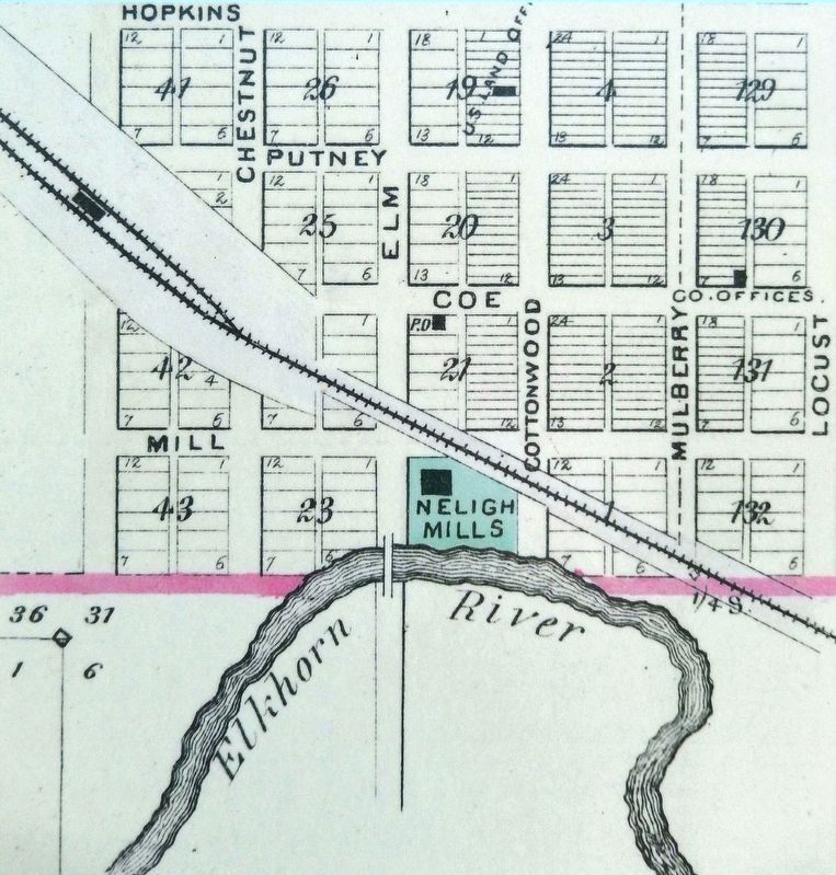
Water = Power The Elkhorn River was an unlimited source of water power for flour mills and other manufacturing enterprises. But entrepreneurs found the meandering river difficult to harness. Too much water was as bad as too little. The key to . . . — — Map (db m158999) HM
On this day the Lewis and Clark Expedition to the Pacific Ocean camped on the bank of the Missouri River at the base of a river landmark near here, now called The Tower. Clark wrote, “Capt Lewis & my Self walked up to the top which forms a Cone and . . . — — Map (db m181800) HM
The ill-fated Pleasanton Nebraska branch extended southwestward along the South Loup Valley from Boelus to Pleasanton, a distance of 22.42 miles. Construction from Boelus to Nantasket was completed in 1887 and reached Pleasanton in 1890. The line . . . — — Map (db m181793) HM
On the South Loup River southwest of here was the site of the U.S. Army’s Post South Loup Fork. This small outpost of Fort Kearney was established in May 1865 by Company “E”, Seventh Iowa Cavalry, under the command of Capt. James B. David and . . . — — Map (db m181699) HM
Moses Shinn and his son Dick began operating Shinn's Ferry across the Platte in 1859. The original site was near Savannah, the first Butler County seat, and a short distance from the present Schuyler bridge. Just above this location the Platte was . . . — — Map (db m39143) HM
During their exploration of the Missouri and Columbia Rivers, Lewis and Clark held councils with Ponca, Omaha, and Sioux Indians inhabiting this region. The council with the Sioux occurred August 28-31, 1804 at Calumet Bluff now the southern . . . — — Map (db m101395) HM
The Missouri, the continent's longest river, figures prominently in the unfolding of America's saga. Flowing nearby in its 2,341 - mile course from the Rocky Mountains to the Mississippi, the Big Muddy is not only loaded with sediment but . . . — — Map (db m101394) HM
Champion, on the Frenchman River (Creek), is the site of probably the oldest functioning water-powered mill in Nebraska. Preliminary construction on the mill was begun in the fall of 1886. The work was completed and the mill placed in operation by . . . — — Map (db m79376) HM
When the Lewis and Clark Expedition to the Pacific Ocean went through this area their mood was undoubtedly gloomy. On the previous day they had buried their comrade, Sergeant Charles Floyd, who died of a ruptured appendix. Although he was the . . . — — Map (db m206919) HM
About 1½ miles north of this spot is the abandoned site of "Old St. John's," one of the first towns established in Dakota County. The townsite was settled on June 2, 1856, by the Father Trecy Colony — sixty people, with eighteen ox-drawn covered . . . — — Map (db m158996) HM
Organized May 3, 1873, when Perkins was still a part of Keith County. The southwest corner is the southwest corner section eighteen of township twelve, north, range forty-one of the 6th P.M.
Both the north and south Platte Rivers traverse . . . — — Map (db m119439) HM
Pioneers traveling west on the Oregon Trail discovered this spring that Plains Indians had frequented for centuries. It provided an oasis for man and beast alike in the “Great American Desert.’
In 1867, Union Pacific railroad workers named it . . . — — Map (db m51461) HM
This short trail leads to two overlooks that offer views of a natural, free-flowing segment of the Missouri River. Here, the river still meanders through the countryside much as it did in Lewis and Clark's day. At the first overlook, exhibits . . . — — Map (db m15114) HM
The Missouri, the continent's longest river, figures prominently in the unfolding of America's saga. Flowing nearby in its 2,341-mile course from the Rocky Mountains to the Mississippi, the Big Muddy is not only loaded with sediment but steeped in . . . — — Map (db m15113) HM
When French traders and trappers explored the river in the early 1700's, the Ioway Indians occupied this area. Later explorers, such as Lewis and Clark, also traveled the Missouri. White settlement began in the late 1850's when the Omaha and Ponca, . . . — — Map (db m170764) HM
This Bridge is on the Mormon Pioneer Trail from Nauvoo, Illinois, to the Rocky Mountains. Driven from their homes by mobs, many of the dispossessed Mormon people crossed the Mississippi River on the ice in February, 1846. From these refugees five . . . — — Map (db m90469) HM
In 1803 the Missouri River carried the hopes of the young United States in its dark and unpredictable waters. President Thomas Jefferson sought a "direct & practicable water communication across the continent, for the purposes of commerce." The . . . — — Map (db m72059) HM
The Missouri River is the longest river in the United States. It stretches 2,341 miles from its headwaters at Three Forks, Montana, to where it meets the Mississippi River at St. Louis, Missouri. Its watershed covers one-sixth of the United . . . — — Map (db m72062) HM
A river forever changed by the power of humans flows beneath this bridge.
For more than a century, man has worked to tame the natural cycles of the Missouri River and exploit its power. There are benefits. Dams hold back floodwaters that once . . . — — Map (db m72066) HM
The 2011 Missouri River Flood was triggered by record snowfall in the Rocky Mountains of Montana and Wyoming and near record spring rainfall in the upper Missouri River Basin. High water levels threatened communities of all sizes along the river . . . — — Map (db m83302) HM
William Brown is credited as Omaha's founder (although not its first settler). He operated a Missouri River ferry from Council Bluffs and was a principal in the company that first developed the Omaha townsite.
Mr. Brown came west as a young man . . . — — Map (db m58275) HM
Since times unrecorded, springs from the Ogallala Formation relieved travelers through the Republican Valley. In 1930 Benkelman citizens improved a nearby spring to benefit motorists on NE 3 (later US 34). The 1935 Republican River flood destroyed . . . — — Map (db m180993) HM
When Frontier County was organized in 1872, Stockville became the county seat. During its first decade no real town existed, it being only a trading center for the ranchers of the region. It was not until the middle-eighties, when the county filled . . . — — Map (db m223453) HM
On May 30, 1935, torrential rains fell in eastern Colorado and southwestern Nebraska; by early morning of the 31st, the usually peaceful Republican River was running bluff-to-bluff along its upper reaches. When the waters subsided two days later, . . . — — Map (db m48549) HM
Many Heritage Highway communities began as river settlements. Beatrice was founded in 1857 near the bend of the Big Blue River. The first building, known as Pap Towle's cabin, was constructed just north of the present Gage County Historical Society . . . — — Map (db m47627) HM
In Beatrice, industries pooled resources to obtain defense contracts by creating Homestead Industries, Inc. This "war production pool of industries" included Dempster Industries, Store Kraft Manufacturing, W.M. Haith Tank Works, Beatrice Steel . . . — — Map (db m48270) HM
In 1872, settlement pioneered by Charles H. Jones in what is now Garfield County, followed the North Loup River northwestward to its junction with the Calamus River. In 1875, the post office serving the area near the confluence of the rivers was . . . — — Map (db m181898) HM
The source of the Calamus River is spring-fed Moon Lake, 60 miles northwest of here. The river was named after a common marsh plant eaten by muskrats. Archeological evidence indicates that prehistoric Indians camped in the valley as early as 3,000 . . . — — Map (db m189344) HM
The North Loup Project was authorized as a multi-purpose flood control and irrigation project by the Flood Control Act of 1944. The Twin Loups Reclamation District, organized in January 1954, and The Twin Loups Irrigation District, organized in . . . — — Map (db m189376) HM
You are near the Platte River's famous Grand Island. It is approximately forty miles in length and two miles at its widest. Providing abundant wood and water, it often served as a campsite for Pawnee Indians. Journalists for the expeditions of . . . — — Map (db m79694) HM
Grand Island, in the Platte River, has given its name to the city of Grand Island. The island was formed by a narrow channel branching off the Platte River approximately 28 miles upstream from the present city of Grand Island and rejoining the main . . . — — Map (db m53258) HM
From 1847 to the 1860s, the Mormon migration along the Great Platte River Road marked a distinctive chapter in the history of westward expansion. In contrast to the random migrations of individual families or companies that characterized much of . . . — — Map (db m79695) HM
The trail which followed the south side of the Platte River was the main route to Oregon and California. Fur traders going to the Rocky Mountains took the first wagons over the trail in 1830. Oregon-bound missionaries followed in the mid-1830s, and . . . — — Map (db m53268) HM
For the 215 miles from the Nebraska-Colorado Line to Grand Island. Interstate 80 parallels the Platte River. This broad flat valley is underlain by deposits of sand and gravel washing in from the Rock Mountains. These deposits contain large . . . — — Map (db m51255) HM
In 1910 the Kimball Irrigation District voted to construct an irrigation system with a reservoir and two canals. The rough topography traversed by the canals required several aqueducts, which used flumes manufactured in Kimball, Nebraska, by . . . — — Map (db m178497) HM
On its journey to the Pacific Ocean the Lewis and Clark Expedition camped near here on September 2, 1804. At this camp the explorers’ imagination and knowledge of military fortifications misled them into concluding that sand ridges and mounds left . . . — — Map (db m181799) HM
maN zhaN (the land) is xube' (sacred) to the Ponca People as is Ni' (water). Following forced removal of the Ponca Tribe to Oklahoma, the tribe split into two groups. The members that stayed in Oklahoma are now referred to . . . — — Map (db m192657) HM
On the night of June 2, 1969, while on maneuvers in the South China Sea off the coast of Vietnam, the Australian aircraft carrier Melbourne was in collision with the destroyer USS Frank E. Evans. The impact cut the Evans in . . . — — Map (db m181893) HM WM
Our villages and old trails were always located near rivers or streams. Waterways were the highways of days gone by, and we used them for travel and trade. Sometimes they would also function as natural yet strategic barriers between one tribe and . . . — — Map (db m192599) HM
This giant plow was used to dig drainage ditches along the Nemaha River in eastern Nebraska, the Platte River here in Lincoln County, the Medicine Creek south of here in Frontier County, near Big Springs, Nebraska, and in Colorado and Wyoming. . . . — — Map (db m191851) HM
Near here at a point midway between the source of the Elkhorn River and its entry into the Platte, is the town of Meadow Grove. The Elkhorn Valley has long been an important passageway for travelers and settlers. In 1739, the Mallet brothers made . . . — — Map (db m182088) HM
Mud Springs, so-named for its seeps of water, was an oasis on the dry plateau between Lodgepole Creek and the North Platte River. Overland travelers began using the springs in the late 1850s when a cutoff was laid out from Old Julesburg to . . . — — Map (db m223466) HM
This Lily Pond was originally constructed in 1930, using a steam engine flywheel belonging to Western Public Service Company, the electrical supplier to the City of Auburn at that time.
The Pond was restored in 2004-2005 as an Eagle Scout . . . — — Map (db m48134) HM
On August 29, 1854, shortly after the Kansas-Nebraska Act had opened the territory west of the Missouri River to permanent settlement, Richard Brown arrived on the site of the town which was to bear his name. Other settlers soon followed. . . . — — Map (db m177299) HM
The Lewis & Clark Expedition Barge/Keelboat was 55 feet long and 8 feet 4 inches wide and drew 2 to 2.5 foot [sic] of water when loaded with an estimated 12 to 15 ton[s] of supplies. The preponderance of the historic evidence indicates that it . . . — — Map (db m66982) HM
Today, the Missouri River is 2315 miles in length. At Nebraska City it is 1755 miles from the headwaters in Montana and 560 miles to its mouth near St. Louis, MO. where it empties into the Mississippi River. It is North America's longest river . . . — — Map (db m66978) HM
Andrew Jackson Higgins, designer and manufacturer of World War II landing craft known as "Higgins boats," was born August 28, 1886, at Columbus, Nebraska. His parents were John Gonegle Higgins, a prominent lawyer and judge, and Annie Long O'Connor . . . — — Map (db m9775) HM
The Columbus Powerhouse is one of Nebraska’s largest hydroelectric generating plants and the pulse of the Loup River Public Power District hydroelectric system. The system was financed in 1933 by a $7.3 million New Deal Public Works Administration . . . — — Map (db m182100) HM
In 1492 Christopher Columbus, his crew and three ships, the Nina, Pinta and Santa Maria set sail from Spain to the New World. That voyage is depicted in the scene above as we pay tribute to the man, the voyage and the community namesake. . . . — — Map (db m59855) HM
In 1847, Brigham Young led 143 men, 2 women, and 3 children west along the Platte River, then southwest into Utah. By the 1860s, an exodus of more than 70,000 other Mormons followed this trail to their "New Zion." Today, a marked 1,624-mile auto . . . — — Map (db m53192) HM
The history of Duncan, Nebraska has been closely associated with overland routes through the Platte and Loup River valleys. The Mormon Trail passed nearby during the mid-19th Century and the first transcontinental railroad was completed to this . . . — — Map (db m53194) HM
Harry D. Strunk dedicated his life to the development of southwest Nebraska and northwest Kansas as founder and president of the Republican Valley Conservation Association. Motivated by the Republican River Flood of 1935 that claimed more than 100 . . . — — Map (db m177000) HM
Eastbound travelers will soon cross the Platte River, which has paralleled the Interstate across most of Nebraska. It has long been noted for its great width and shallow depth. The Platte is a major tributary of the Missouri River, which it flows . . . — — Map (db m78022) HM
In Memory of U.S.S. Wahoo SS 238 and her gallant crew who sank 20 Japanese ships before being sunk by enemy action October 11, 1943.
Crew of the U.S.S. Wahoo still on patrol. — — Map (db m93184) WM
”For more than a century, the Platte River provided a natural path for pioneers traveling West, a water source for herds of bison and a harvesting region for fur trappers. Even today, the river’s impact is enormous; it is the single largest source . . . — — Map (db m191406) HM
Hiram Scott, employee of the Rocky Mountain Fur Company, died in the vicinity of this bluff in 1828. After being deserted by his companions near the junction of the Laramie and North Platte Rivers. — — Map (db m86783) HM
Except for the occasional Indian or white hunting parties, the scenic valley of the Big Blue River was seldom visited prior to 1860. The establishment of the Nebraska City-Fort Kearny Cutoff in 1861 brought through the region thousands of overland . . . — — Map (db m78021) HM
On this day, a "bomb cyclone" dropped up to 4 inches of rain on several inches of wet snow on frozen soil. The rapidly melting snow caused flooding on the Big Blue River and Plum Creek. Traffic on Highway 34 west of town was closed, flood water . . . — — Map (db m182040) HM
In April 1873, Headquarters, Department of the Platte at Omaha, ordered a military scout of the North and Middle Loup River Valleys. The detachment of soldiers was commanded by Captain John Mix of Company M, of the Second Cavalry, and guided by . . . — — Map (db m179395) HM
The town of DeSoto was platted on this site in 1854 and incorporated in 1855. Steamboating on the Missouri was then in its heyday. DeSoto provided a landing for passengers and goods. A number of boats sank nearby, notably the Cora and . . . — — Map (db m7837) HM
During the mid-nineteenth century, steamboats played a major role in the settlement and development of the nation. In March 1865 the fully laden sternwheeler Bertrand left St. Louis under command of Captain James Yore. The cargo of general . . . — — Map (db m74161) HM
During the summer of 1804, the river below looked very different. Unlike today’s course controlled by dams and dikes, the Missouri River that Lewis and Clark knew flowed wild and erratic. Strong currents, floating branches, embedded logs, . . . — — Map (db m76885) HM
Pibel Lake grew out of an 1897-1898 irrigation claim for water rights by Edwin Pibel, called Clear Creek Ditch. Three years earlier, a diversion dam had been placed across the creek to form a lake, but the irrigation ditch was eventually abandoned . . . — — Map (db m179426) HM