On Cushman Street at 4th Avenue on Cushman Street.
Noticeable among the earliest pioneers settling in Fairbanks were prostitutes, women of the demimonde who stampeded to the new Fairbanks gold camp from Dawson, Circle City, Rampart and points beyond. In a city where men far outnumbered women, . . . — — Map (db m47404) HM
On Richardson Highway (Alaska Route 2), on the right when traveling south.
Gold discoveries brought Alaska and the Yukon to the attention of the world. A series of stampedes occurred over more than three decades. Drawn by dreams of gold, men and women from many places and all walks of life participated in an adventure that . . . — — Map (db m59836) HM
Dredges were brought in to mine gold-bearing deposits in the Fairbanks mining district after 1920. This bucket-line or ladder dredge has 68 buckets, each with a capacity of 6 cubit feet. The bucket line was driven by a 150 horsepower motor that . . . — — Map (db m144242) HM
On Steese Highway (Alaska Route 2), on the right when traveling north.
Dr. Maple was a structural engineer and principal designer of the trans-Alaska pipeline. He holds three patents for his development of innovative pipe supports that enabled the warm oil pipeline to safely traverse areas of permafrost. He pioneered . . . — — Map (db m58949) HM
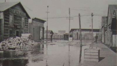
On Second Avenue, on the right when traveling east.
Construction of the Lacey Street Theater began in 1939, and this Art Deco style building opened in 1940. Austin E. “Cap” Lathrop, Fairbanks businessman and financier, was its owner. The Lacey Street Theater, with its distinguished neon . . . — — Map (db m58989) HM
On Steese Highway (State Highway 2), on the right when traveling north.
• Length: 800 miles
• Diameter: 48 inches
• Crosses three mountain ranges and more than 500 rivers and streams
• Cost to build: $8 billion in 1977, the largest privately funded construction project at that time
• Construction began March . . . — — Map (db m175383) HM
Near Steese Highway (at milepost 8.4), on the right when traveling north.
On November 16, 1973, through Presidential approval of pipeline legislation, Alyeska Pipeline Service Company received permission to begin construction of the 800-mile trans Alaska pipeline, its pump stations and the Marine Terminal at Valdez. . . . — — Map (db m20215) HM
On Richardson Highway (Alaska Route 2), on the right when traveling south.
The gold deposit found in 1902 north of present-day Fairbanks proved to be the richest in Alaska. Prospector Felix Pedro and trader E.T. Barnette played key roles in the discovery and initial rush. A second strike made the following summer . . . — — Map (db m59826) HM
Captain E.T. Barnette, whose trading post on the Chena River became the city of Fairbanks, arrived here on the sternwheeler Lavelle Young with Captain Adams on August 26, 1901.
Felix Pedro and partners, mining for gold in the hills above town, saw . . . — — Map (db m47382) HM
This Sign Greeted New Arrivals As They Arrived At The Pipeline Construction Camp Located One Mile West Of Here. We Salvaged This Sign When The Camp Was Being Dismantled.
You are about 55 miles north of the Arctic Circle on the East Bank . . . — — Map (db m49597) HM
Two regional airlines founded here in the mid-1930's, eventually merged with Alaska Airlines. In that sense, they still serve Juneau today. Each began as a one-plane flying company.
Sheldon “Shell” Simmons' Alaska Air Transport Company was . . . — — Map (db m181843) HM
Near South Franklin Street, 0.5 miles north of Mr. Roberts Street.
At the Alaska Juneau mill from 1917-1944, ore was sorted, crushed, and treated to extract gold. Electric-powered engines hauled trains of 40 ore cars along the main haulage route form the mine two miles away in Silver Bow Basin to the AJ mill, . . . — — Map (db m42823) HM
On South Franklin Street, on the right when traveling north.
built September 16, 1913
has been placed on the
National Register
of Historic Places
by the United States
Department of the Interior — — Map (db m181762) HM
The Cape Decision lighthouse was the last one built in Alaska. Need for it grew as ship traffic and the size of the ships increased. Southeast Alaska was booming with many salmon canneries, herring salteries and whale oil reduction plants. Large . . . — — Map (db m181646) HM
Although most materials needed by the historic mining industry came in downtown, one important commodity was off-loaded at the Dupont Dock, about 5 miles south of town. Dynamite was considered too much of a threat to deliver to the town's commercial . . . — — Map (db m181783) HM
Near Marine Way near South Franklin Street, on the left when traveling west.
This bronze sculpture was commissioned by the city and borough of Juneau during its centennial anniversary year, and is dedicated to the mine whose work provided the lifeblood of Juneau during it first six decades.
In the late 1800’s, compressed . . . — — Map (db m42809) HM
Between 1929 and 1932, passengers could fly between Juneau's waterfront and downtown Seattle on scheduled weekly flights of Alaska-Washington Consolidated Airways. The fare was $105.
Juneau's harbor was home to three pioneer flying companies that . . . — — Map (db m181821) HM
Local ferries once plied a triangular route linking Juneau, Douglas, and Thane. These three communities, each centered on a major mine, eventually merged into one. In 1935, a bridge was constructed linking Douglas Island with the mainland.
In . . . — — Map (db m181794) HM
Steamships brought passengers as well as goods. During the heyday of steam travel, there was a ship at the dock almost every day. In 1918, the Canadian Pacific Line's Princess Sophia was bound for this harbor when the ship foundered on a reef . . . — — Map (db m181792) HM
Near Admiral Way at South Franklin Street, on the right when traveling west.
The Alaska Juneau (AJ) mine operated from 1917 to 1944, producing 90 million tons of gold bearing ore, and was one of the largest mines in the world at the time. In the 1930's the AJ mine employed around 1000 people, produced 12,000 tons of ore per . . . — — Map (db m181772) HM
On 3rd Street at North Franklin Street, on the right when traveling west on 3rd Street.
has been placed on the
National Register
of Historic Places
by the United States
Department of the Interior
built • restored
1925 • 2000 — — Map (db m181759) HM
Waterfront cold storage buildings supported the fishing industry while warehouses stored the freight that came and went. All goods coming into town — from the nuts and bolts of industry to walnuts and bolts of calico — were offloaded here. Outbound . . . — — Map (db m181784) HM
Pelton wheels are among the most efficient types of water wheels. It was invented by Lester Allan Pelton (1829-1908) in the 1870s, and is an impulse machine, meaning that it uses Newton’s second law to extract energy from a jet of fluid. It . . . — — Map (db m70762) HM
Near Creek Street (Alaska Route 7) north of Stedman Street.
Beatrice Greene; the last working woman
For half a century, this house, like so many on the Creek, was part of Ketchikan’s notorious red light district where both fish and men came upstream to spawn… the fish once, many of the men . . . — — Map (db m112041) HM
Ketchikan's notorious Creek Street, early Alaska's most infamous red-light district, still retains traces of the gaudy rouge of a half-century of speakeasies and sporting women. Here the fame of Black Mary, Thelma Baker and Dolly Arthur . . . — — Map (db m182103) HM
On Creek Street at Stedman Street (Alaska Route 7) on Creek Street.
Ketchikan’s notorious Creek Street, early Alaska’s most infamous red-light district, still retains traces of the gaudy rouge of a half-century of speakeasies and sporting women. Here the fame of Black Mary, Thelma Baker and Dolly Arthur outlived . . . — — Map (db m112039) HM
On Stedman Street north of Thomas Street, on the right when traveling north.
Laws restricting Chinese and Japanese immigration in the 1920s resulted in a wave of Filipinos coming to work in Ketchikan's booming canneries. These “Alaskeros,” as they called themselves, began to live here permanently and make long-lasting . . . — — Map (db m182101) HM
Near Creek Street (Alaska Route 7) north of Stedman Street, on the right when traveling north.
Dolly Arthur… one of the Creek’s longest “working” residents
This house was the home of Dolly Arthur, Ketchikan’s most famous “sporting woman.”
From 1919 through the 1940s, it was also her place of business.
Dolly, whose given name . . . — — Map (db m112038) HM
The Politics of Prohibition pitted the U. S. Constitution's well-meaning 18th Amendment — which banned the manufacture, sale or transportation of liquor — against the ingenuity of the moonshiners and bootleggers who found ways to satisfy the . . . — — Map (db m182102) HM
On Creek Street at Stedman Street, on the right when traveling north on Creek Street.
In spite of its more respectable Stedman Street address, this building — along with its Creek Street neighbors — was one of the earliest houses of prostitution, built soon after the Town Council banned prostitution to this side of the Creek. . . . — — Map (db m182042) HM
On Front Street at Water Street, on the right when traveling south on Front Street.
Shipments of iced halibut from Ketchikan to outside markets was pioneered by F.J. Hunt and H.C. Strong, following similar successful methods with salmon, and a thriving business was built through the construction of two large cold storage . . . — — Map (db m181914) HM
On this site over 100 years ago, a 22-foot waterwheel turned, creaked, and groaned to power the Ketchikan Shingle Mill. It was an ingenious creation of pioneer Austin “Ott” Inman.
Inman and his partner, Charles Borch, first used the mill as a . . . — — Map (db m182074) HM
On Stedman Street south of Creek Street, on the right when traveling north.
Adventurous Japanese-Americans George and Yayoko Shimizu immigrated to Ketchikan in search of opportunity. Around 1903, they opened the New York Café on downtown Front Street.
Ketchikan was divided racially then. Whites lived north of Ketchikan . . . — — Map (db m182073) HM
On Stedman Street south of Creek Street, on the left when traveling south.
Around 1900, adventurous Japanese pioneer George Ohashi came to Ketchikan and opened the New York Café on Front Street. This was the beginning of a three-generation Ohashi family career of entrepreneurial activities.
In 1907, Ohashi built this . . . — — Map (db m182044) HM
On Front Street at Mill Street, on the right when traveling south on Front Street.
[Left side, top to bottom]
(Top photo) Illegible
The young city of Ketchikan (remainder illegible)
The Sideboard Saloon was operated by town co-founder Mike Martin from early in the century until 1917, when the . . . — — Map (db m181993) HM
On Front Street at Spruce Mill Way, on the right when traveling south on Front Street.
E pluribus funum
Independence Day was a bang-up community affair in early-day Ketchikan. In the midst of busy summertime, the Stars and Stripes provided a common denominator for diverse frontier folk. July Fourth inspired considerable . . . — — Map (db m181996) HM
One of Ketchikan's oldest buildings and the Territory of Alaska's only registered brothel.
Infamous owner “Black Mary” Thomas added a dance hall with an inlaid star in the floor, giving the building its name.
Thelma Baker Graham bought the . . . — — Map (db m182087) HM
On Front Street at Mission Street, on the right when traveling south on Front Street.
Hundreds of proud sailing vessels once plied Alaskan waters, but the passing of the wail was swift & complete. As the new Era of the Steamship began to dominate the sea lanes in the late 1890's, Alaska's booming early salmon trade inspired the . . . — — Map (db m181943) HM
On Stedman Street south of Creek Street, on the left when traveling south.
Across the great divide: Stedman started apart
Ketchikan Creek formed a dividing line in Ketchikan in the early 1900s. To the north, white pioneers' homes, schools and churches stair-stepped up the hill and businesses crowded the waterfront. . . . — — Map (db m182050) HM
On Stedman Street at Thomas Street, on the right when traveling north on Stedman Street.
Kichirobei (“Jimmy”) Tatsuda and his wife, Sen Seike, started a combination grocery store, pool hall, tobacco shop and boarding house in 1910.
In 1916, the Tatsudas opened their first grocery store in a nearby building. It was truly a family . . . — — Map (db m182093) HM
On Stedman Street south of Creek Street, on the left when traveling south.
Stedman Street was a congenial place for Japanese immigrants and their families up to the 1940s. Japanese-born miners, fishermen, laborers and entrepreneurs settled across the creek from downtown and founded families. Japanese-Americans from the . . . — — Map (db m182058) HM
On Front Street at Water Street, on the right when traveling south on Front Street.
“Thundering Wings” — the title of local master carver Nathan Jackson's magnificent cedar monument, depicts the Tlingit native origin of Ketchikan's name, as told by Chief Reynold Denny of the Beaver Clan:
“About three hundred years ago the . . . — — Map (db m181908) HM
On Front Street at Mission Street, on the right when traveling south on Front Street.
Prior to the 1870s, only a hardy handful of explorers, traders, whalers and sealers worked Alaska's rugged coastline. Following the 1867 purchase of the Territory from Russia, regular boat service from U.S. ports to Sitka began on a monthly . . . — — Map (db m181965) HM
This place was central to Russia's hopes of establishing a lucrative colony in America.
Finding a Foothold
Starting in the 1740s, Russians were attracted to Alaska's coast by abundant, valuable sea otters. Russia claimed Alaska and . . . — — Map (db m181348) HM
Tlingit people established ties to this place long ago and those ties, though altered, remain.
The Land and the Tlingit
The ocean and the forest met the Tlingit peoples' needs as they moved from summer fish camps to autumn hunting grounds . . . — — Map (db m181331) HM
On Harbor Drive at Maksoutoff Street, on the right when traveling east on Harbor Drive.
Norman E. Staton Sr. and Ethel L. (Milonich) Staton, lifelong Alaskans moved from Ketchikan to Sitka in 1955 opening their first restaurant, the Pioneer Grill on Katlian Street and their second, the Sitka Café on Lincoln Street before opening . . . — — Map (db m181259) HM
On 6th Avenue at Broadway Street, on the right when traveling north on 6th Avenue.
This Wells Fargo Store began as the Bank of Alaska on March 20, 1916.
In 1950, Bank of Alaska took on a national character as National Bank of Alaska, and went on to become a pioneer and leader in branch banking in Alaska.
In 2000, National . . . — — Map (db m73328) HM
The building before you is an historical structure known as “Jeff. Smith’s Parlor.” It has recently been acquired by Klondike Gold Rush National Historical Park, a unit of the National Park Service. Jeff. Smith’s Parlor, a part of the . . . — — Map (db m72785) HM
On Richardson Highway (Alaska Route 2 at milepost 175).
The community of Big Delta began during the Gold Rush era as a trading post and roadhouse serving prospectors and travelers.
Known for many years as McCarty, Big Delta was a link in the paths of travel and trade. It was located at the . . . — — Map (db m49598) HM
On McCarthy Road (at milepost 29), on the left when traveling west.
From 1911-1938 the Copper River & Northwestern Railway was the lifeline for the Kennecott mines. Nicknamed the “Can't Run & Never Will” by its skeptics, the CR&NW overcame incredible challenges in its construction and operation.
Blasted and . . . — — Map (db m173891) HM