Imagine Northwest Connecticut completely bare of trees. In 30-40 year cycles, from the 1700s to the 1920s, entire hillsides of young trees were cut and cleared. This wood was made into charcoal, the preferred fuel of Connecticut’s brick, iron and . . . — — Map (db m140780) HM
Near South Street (Connecticut Route 63) north of Wolcott Street, on the right when traveling south.
Kitchen gardens, like the one kept by Tapping Reeve and his family, provided reliable sources of food for Litchfield families and occupied a central role in the household economy of 18th-century America. Compared to agricultural fields, kitchen . . . — — Map (db m230287) HM
On Main Street (U.S. 44) at Church Street, on the left when traveling west on Main Street.
In 1732 the Connecticut General Assembly gave Hartford and Windsor permission to establish seven towns in the colony’s Western Lands. New Hartford was given to 182 Hartford taxpayers who became the new town’s proprietors. They organized and hired . . . — — Map (db m92607) HM
On Aspetuck Avenue just south of Old Albany Post Road, on the right when traveling north.
This charming red brick building was built by Senator Elijah Boardman around 1820 and was originally located next to the Boardman house, which still stands today, on Main Street flush with the sidewalk. It was built to be used as a law office for . . . — — Map (db m230176) HM
On Aspetuck Avenue south of Old Albany Post Road, on the right when traveling north.
Elijah Boardman (1760-1823) was the third son of Sherman and Sarah (Bostwick) Boardman. Elijah would later be elected to the U.S. Senate in 1821. After his service in the Continental Army was cut short due to illness, he moved to New Haven where . . . — — Map (db m230205) HM
Near Still River Drive, 0.2 miles east of Pumpkin Hill Road, on the right when traveling east.
About Bridgeport Wood Finishing Company …
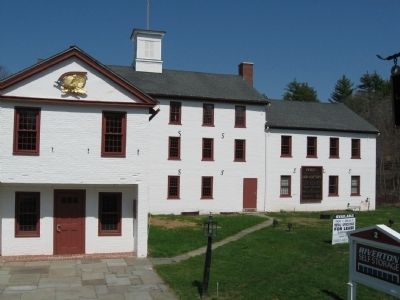
The New Milford site at Great Falls was one of the best unused waterpower sites in Connecticut with three principal advantages when Bridgeport Wood Finishing Company began acquiring property in . . . — — Map (db m22749) HM
Near Lower Road at Furnace Hill Road, on the left when traveling west.
Birth of an Industry
The Iron Works of The 1700's
Iron forges came early to the Blackberry River, with the first Catalan forge built in 1739 downstream from this point. About this time young Samuel Forbes (1729-1827) arrived on the scene, first . . . — — Map (db m41979) HM
Near Lower Road at Furnace Hill Road, on the left when traveling west.
Casting Arch & Furnace Hearth
Casting Arch
This arch was used to gain access to the hearth area of the furnace. It is the largest of the four arches in the furnace structure. It is from this opening that molten iron flowed into sand molds to . . . — — Map (db m41976) HM
Near Lower Road at Furnace Hill Road, on the left when traveling west.
Salamander
This 10-ton chunk of iron formed in the hearth area of the furnace. While there are a number of things that can cause the formation of a salamander this one was probably due to a failure in the masonry of the hearth which allowed molten . . . — — Map (db m41981) HM
Near Lower Road at Furnace Hill Road, on the left when traveling west.
Tuyere Arch
One of three such arches, this opening was used to route hot blast air to the furnace. Simulated piping has been installed in this arch to show how it could have looked when the furnace was in operation. Basically the piping consists of . . . — — Map (db m41982) HM
Near Lower Road at Furnace Hill Road, on the left when traveling west.
What Is This Place?
Beckley Furnace Industrial Monument
You are standing in front of the remains of an iron furnace. This facility, Beckley Furnace, operated from 1847 until 1919, making it one of the last of its kind to operate in the United . . . — — Map (db m41975) HM
On Greystone Road Ext., 0.2 miles east of Greystone Road, on the right when traveling east.
Eli Terry was born April 13, 1772. In 1793 Eli Terry moved to
Plymouth where he was involved in the production of wooden
movement clocks. Due to Terry's manufacturing techniques,
clocks became affordable to the American household. In . . . — — Map (db m90894) HM
On Main Street (U.S. 6) at Benedict Street, on the right when traveling west on Main Street.
The Eli Terry Jr. Water Wheel is believed to be one of only two water wheels of its type in the United States. Originally it supplied power to the Terry Clock Shop located on this property. In the early 1830's the manufacture of locks began. By . . . — — Map (db m90349) HM
Near Mine Hill Road, 0.5 miles west of Hodge Road, on the right when traveling west.
Recognized on the National Register of Historic Places, Mine Hill is the site of a 19th century iron mine and furnace complex. The Roxbury Land Trust acquired the 360-acre preserve in 1978. The significant stone and brick structural remains of the . . . — — Map (db m20555) HM
On Lime Rock Road at White Hollow Road, on the right when traveling east on Lime Rock Road.
For nearly a century Lime Rock was the home of the Barnum & Richardson Company. Started in 1830 by Milo Barnum and his son-in-law Leonard Richardson the company manufactured cast iron goods made from iron smelted locally. The nearest iron furnace . . . — — Map (db m179150) HM
On Main Street at East Main Street, on the right when traveling north on Main Street.
Thomaston’s Three Tower Clocks
In 1872 Seth Thomas Clock Company began manufacturing Tower Clocks. Considered to be a sample of high quality workmanship and an ingenious mechanical feat, Tower Clocks are an architecturally important finger-print of . . . — — Map (db m90351) HM
On Litchfield Street (U.S. 202) at South Main Street, on the left when traveling north on Litchfield Street.
"So numerous were the many acts of heroism, rescue of the sick and invalid, neighbors' concern for neighbors, that it would be impossible to chronicle them with slighting someone deserving of great credit." - Torrington Register, August 26, . . . — — Map (db m54559) HM
On Main Street north of City Hall Avenue, on the right when traveling north.
Named in 1732 for Torrington in Devonshire, England, this was one of the townships of the Western Lands allotted to Windsor. Since the early settlers were taxpayers in that town, their shares in the division of land depended upon the amount of taxes . . . — — Map (db m56057) HM
Near Main Street at Northridge Avenue, on the left when traveling north.
Warrenton Woolen Mill
839 Main Street, Torrington CT
Erected 1908
Listed On The
National Register of Historic Places
1987
Renovated Into The
Warrenton Mill Condominium
1988 — — Map (db m30186) HM
Near Main Street South (U.S. 6) at Sycamore Ave (Connecticut Route 317).
In memory of long time neighbor and friend
Malcolm “Mac” Baldrige
1922 – 1987
Soldier, Industrialist,
Team Roper, Member Cowboy Hall of Fame,
United States Secretary of Commerce 1981-1987,
Recipient United States . . . — — Map (db m19502) HM
On Ferry Road (U.S. 148), on the right when traveling east.
For over two hundred years the Chester-Hadlyme Ferry has provided public transportation at this site. The first crossing was initiated by Johnathan Warner of Chester in 1769. Known as Warner's Ferry, it was privately operated until 1877 when it . . . — — Map (db m61345) HM
Near East Main Street (U.S. 1) at Cemetery Road, on the right when traveling east.
You are standing beside the Indian River in the heart of the 1663 settlement of Killingworth, sited on its protective harbor. In 1838, the shoreline portion parted from northern Killingworth and became Clinton.
Shipbuilding
The first . . . — — Map (db m100187) HM
On East Main Street (U.S. 1) just east of Cemetery Road, on the right when traveling east.
1. Indian River
At the center of the Colonial settlement, this stream winds south through salt marshes to the harbor. Shipyards stood on its banks in the 18th and 19th centuries. The bridge dates from the 1876, replacing an an earlier . . . — — Map (db m227290) HM
On Middlesex Turnpike (Connecticut Route 154) at Elm Street, on the left when traveling north on Middlesex Turnpike.
We Honor the Elephant
During the 1800’s Deep River was the center of America’s ivory trade. Elephant tusks from Africa were brought to Deep River landing for local factories to make piano keys, combs, buttons, and billiard balls. Up to 100,000 . . . — — Map (db m100244) HM
On Main Street at N Main Street, on the left when traveling west on Main Street.
Essex Square as we know it today did not exist until after the British attack on Essex harbor on April 8, 1814 when 28 ships were destroyed. A change in the configuration of the streets leading to the river, thanks to the building of a large, new . . . — — Map (db m183085) HM
On Main Street at Court Street, on the right when traveling north on Main Street.
Near this spot in 1760 stood Timothy Bigelow's tavern, where travellers and local people gathered to drink rum, trade stories, and oonduct business. In 1776, Bigelow died suddenly, leaving his wife Elizabeth with four children to support. Widow . . . — — Map (db m98602) HM
On South Main Street at Pleasant Street, on the left when traveling east on South Main Street.
In 1756, this simple structure was the birthplace of one of New England's leading craft dynasties, the Danforth family of pewterers. For nearly a century, three generations of Danforth men fashioned everything from plain plates to graceful . . . — — Map (db m98550) HM
On Pleasant Street at Main Street, on the left when traveling east on Pleasant Street.
By the end of the Civil War, one of every nine Middletown men wearing the Union uniform was dead. They included young David Lincoln, who gave his life in the Battle of Fredericksburg on December 13, 1862.
More than 900 soldiers and sailors . . . — — Map (db m98603) HM
On Court Street at deKoven Avenue, on the left when traveling east on Court Street.
If you stood here in the late 1700s looking east toward the Connecticut River a forest of ship masts would bob before your eyes. On docks lining the riverside, sailors and merchants bustled back and forth to tall ships which had just arrived in . . . — — Map (db m98549) HM
On Washington Street at deKoven Avenue, on the right when traveling east on Washington Street.
Middletown became of the richest towns in all New England in the 1700s. during that time, thousands of ships loaded with local products like lumber, barrels, horses, pigs, corn, butter, and beef.
The ships sailed down the Connecticut River and . . . — — Map (db m98690) HM
On College Street (Connecticut Route 154) just west of Bridge Street (Connecticut Route 154), on the right when traveling west.
Captain Adriaen Block was a Dutch trader and privateer who journeyed to the Hudson River and Manhattan Island in 1611 to trade for fur with the Lenape people who lived there. Between 1611 and 1614, Block made four voyages during which he explored . . . — — Map (db m227279) HM
On Main Street (Connecticut Route 154) just south of Pennywise Lane, on the right when traveling south.
The first African-American female pharmacist in Connecticut, proprietor of the James Pharmacy and beloved member of the community for generations of residents and visitors. Known to all as "Miss James," she represented the humanitarian spirit that . . . — — Map (db m227270) HM
On College Street (Connecticut Route 154) just west of Bridge Street (Connecticut Route 154), on the right when traveling west.
Because of the combination of fresh and saltwater habitats at the river's mouth, a wide variety of fish species have the opportunity to feed, reproduce and/or establish populations.
The Native American diet depended on this variety and . . . — — Map (db m227284) HM
On Main Street north of Freestone Avenue, on the right when traveling north.
The Holt Brothers and Redding Iron Works of California manufactured and shipped logging arches, throughout the United States in the late 1800's. Pulled by teams of oxen, arches were used in Portland to transfer cut brownstone from the quarries. . . . — — Map (db m216460) HM
On Main Street north of Freestone Avenue, on the right when traveling north.
Formerly known as East Middletown (1714-1767), later as Chatham (1767-1841), Portland was incorporated in 1841. Land had been granted on the east side of the Connecticut River in 1652; the first permanent settler, James Stancliff, a stone cutter, . . . — — Map (db m216455) HM
On Main Street north of Freestone Avenue, on the right when traveling north.
Just west of here are Portland's Brownstone Quarries, designated a National Historic Landmark in 1998. The history of Portland is a remarkable reflection of the immigration patterns and technology associated with the American Industrial . . . — — Map (db m216456) HM
On Middlesex Avenue at Brownstone Avenue, on the left when traveling west on Middlesex Avenue.
Portland: “A History Carved in Brownstone”
Early colonists in Connecticut gazed across to the eastern shore of the big bend in the Connecticut River at the outcroppings of reddish-brown sandstone. Little did they know that this stone . . . — — Map (db m140234) HM
On Whitney Avenue at Dixwell Avenue (Connecticut Route 10), on the left when traveling south on Whitney Avenue.
The Town of Hamden gratefully accepts the donation of the Campanile and the electronic Carillon by the children of Philip Paolella in honor of Ciro Paolella, founder and president of the Plasticrete Corporation.
Born in Italy, . . . — — Map (db m28699) HM
On Whitney Avenue at Armory Street, on the right when traveling north on Whitney Avenue.
On this site in 1798, Eli Whitney established the first manufactory for the production of fire arms in the United States. Here he invented and used the uniformity system of manufacture now adopted throughout the world. — — Map (db m28744) HM
On Whitney Avenue at Armory Street, on the right when traveling north on Whitney Avenue.
ASM International - The Materials Information Society - has designated the Eli Whitney Armory an historical landmark. "On this site between 1798 and 1825, Eli Whitney built the first significant independent American armory. The development of . . . — — Map (db m28750) HM
On Whittemore Road (Connecticut Route 188) at Store Road, on the left when traveling west on Whittemore Road.
At the site of Perrotti's West Street Pizza & Pub the trolley passed under Route 188 and then was moved from its original site at Westover School in 1908. The Bissell Store became the Ferrante and Delaney Store and was destroyed by fire in 1940. . . . — — Map (db m29487) HM
On North Street at Middlebury Road (Connecticut Route 64), on the left when traveling north on North Street.
This old house was once part of the Julius and Augusta Bronson Farm. The family of Samuel and Sarah Fenn owned it from 1887 to 1923. This house was purchased by the Blick Family in 1936 and the Middlebury Garage was established in 1937. The house . . . — — Map (db m29491) HM
On Store Road at Middlebury Road (Connecticut Route 64), on the right when traveling north on Store Road.
Westover School located across from the Green was once the location of the original Blacksmith Shop. It was later relocated to Store Rd. near the spot where the old trolley waiting room was once located. The blacksmith shop has a long history dating . . . — — Map (db m29530) HM
On Church Street at Division Street, on the right when traveling south on Church Street.
(Front)
These lands were settled in 1702 by Samuel Hickox, Jr. of Mattatuck, now called Waterbury. Eight years later he began operation of a fulling mill, the first of many and diverse industries to follow. The earliest school was built . . . — — Map (db m23917) HM
Near Grove Street at High Street, on the right when traveling north.
[ west side ]
Eli Whitney
The inventor of the Cotton Gin.
Of useful science & arts the efficient
patron & improver
[ east side ]
In the social relations of life a model of excellence.
While private affection weeps at his . . . — — Map (db m49602) HM
Near Grove Street at High Street, on the right when traveling north.
Ithiel Town
Architect
Inventor of the lattice truss bridge
Designer and builder of Center
Church and Trinity Church and
other notable buildings in New
Haven. One of the founders of
The National Academy of Design.
Born at Thompson, . . . — — Map (db m49603) HM
On Church Street at Court Street, on the left when traveling north on Church Street.
The fountain around the Memorial Flagpole commemorates 150 years of service by the New Haven Water Company founded by Eli Whitney. The first water was brought to the Green from Lake Whitney on January 1, 1862 in order to provide fresh water for . . . — — Map (db m35174) HM
Near Grove Street at High Street, on the right when traveling north.
Pelatiah Perit
Died in New Haven
March 8, 1864,
Aged 78 Years.
He was born in Norwich, Conn. and educated at Yale College. For more than fifty years a merchant in New York, in which city he was for ten years president of the Chanber of . . . — — Map (db m50916) HM
Near State Street north of Chapel Street, on the right when traveling north.
'Prince E. Gray, one of the best known men on the New Haven, has made waiting an art. [Gray] has put his son and daughter through college.
Portrait of Prince E. Gray, Along the Line, railroad employee . . . — — Map (db m227298) HM
On Chapel Street at College Street, on the left when traveling east on Chapel Street.
In July of 1865 Pierre L'allement left his native France for America with the makings of a primitive iron bicycle in tow. That fall the 22-year-old mechanic settled in Ansonia about 12 miles west of here. The following April he rode his . . . — — Map (db m227297) HM
Near Woodward Avenue at Pope Street, on the right when traveling south.
The Oyster Industry in New Haven
History
1638 First settlers arrive in New Haven and are introduced to oysters by local Indians. Oysters were so plentiful people could pick them up by hand. The oyster beds stretched from the upper . . . — — Map (db m35728) HM
On Quinnipiac Street (Connecticut Route 150) at Ward Street, on the right when traveling east on Quinnipiac Street.
Robert Wallace who made the first nickel silver spoon manufactured in this country in 1835 laid the foundation stone of this business.
This tablet is erected in appreciation by the employees of the R. Wallace & Sons Mfg. Co. and the Wallingford . . . — — Map (db m27570) HM
On Boardwalk, 0.3 miles east of Baptist Lane, on the left when traveling east.
East Lyme was settled in the 1650s and became incorporated as a town in 1839. Records from 1840 indicated that 1,412 people lived in this 34.8 square mile town. An important settlement in the area was the Thomas Lee house that was built in 1660. . . . — — Map (db m227268) HM
Near Boardwalk just east of Baptist Lane, on the left when traveling east.
The railroad between New Haven and New London was originally a single track. To allow for higher speed and more frequent trains the railroad was double-tracked and completed in 1894. At that time the "Hole in the Wall" was constructed. Underpasses . . . — — Map (db m227249) HM
On Jewish War Veterans Memorial Highway (Interstate 95) 0.5 miles east of Mystic Street (Connecticut Route 614), on the right when traveling east.
Prior to 1800 the Mystic River Valley was a sparsely settled region. The population depended upon agriculture for subsistence and occasionally profit. The leading historical event during the colonial period had been the defeat and the near . . . — — Map (db m226772) HM
On Church Hill Road at Spicer Hill Road, on the left when traveling north on Church Hill Road.
Gurdon Bill’s Station
( 1816 )
This country store and stagecoach way station was once a meeting place of local residents and passing travelers. The building retains its original features and location. Two important roads of early New England . . . — — Map (db m231786) HM
On State Street just east of Green Street, on the left when traveling west.
Built for Morris W. Bacon, manager of the Pequot & Ocean Transit Steamship Co. Bacon, as a member of the New York Yacht Club won the acclaimed cup. — — Map (db m227234) HM
On Bank Street east of Pearl Street, on the left when traveling east.
Originally the A. Rudd Feed & Grain Co. The elevator, built to carry bulk feed, was well suited for the building’s next use — a furniture store, which thrived here for many years.
New London Main Street 2006
Funded by City Center . . . — — Map (db m217022) HM
On Bank Street east of Pearl Street, on the right when traveling east.
Built in the Greek Revival style for the home of Franklin Smith, partner in the Perkins & Smith whaling firm.
New London Main Street 2006
Funded by City Center District & City of New London, Maritime Heritage Park Grant — — Map (db m217023) HM
On State Street at Green Street, on the left when traveling west on State Street.
Originally the site of L. Lewis Co., a crockery and glassware store. Local architect James Sweeney, designer of 243 and 181 State Street, had his office here. — — Map (db m227190) HM
Built in the neoclassical style for Joseph Lawrence, head of a prominent New London whaling family, as a hall for lectures and exhibits. Historic Waterfront District Heritage Trail New London Main Street 2006 Funded by City Center District & City . . . — — Map (db m48637) HM
On State Street west of Green Street, on the left when traveling west.
Oldest building on State Street. Originally Timothy Green's print shop, which published one of the colony's earliest newspaper. — — Map (db m227191) HM
On Bank Street at State Street, on the right when traveling north on Bank Street.
Figureheads in cornice reflect New London’s maritime tradition. Originally housed the New England Cigar and Tobacco Company. Historic Waterfront District Heritage Trail New London Main Street 2006 Funded by City Center District & City of New . . . — — Map (db m48633) HM
On State Street just west of Green Street, on the right when traveling west.
By Leopold Fidlitz, born in Prague and educated at Viennese Polytechnic for Jonathan Newton Harris who made his fortune in patent medicine. — — Map (db m227226) HM
On State Street at Water Street, on the right when traveling south on State Street.
Built as a warehouse and ships chandlery for the whaling firm of Perkins & Smith. In 1889, became the Winthrop Hotel to recognize the city’s founder, John Winthrop Jr. Historic Waterfront District Heritage Trail New London Main Street 2006 Funded . . . — — Map (db m48636) HM
On State Street just west of Bank Street, on the left when traveling west.
By Dudley St. Clair Donnelly, a prominent New London architect who designed 150 State Street and a number of other buildings in the district. — — Map (db m227232) HM
On Hempstead Street just north of Garvin Street, on the left when traveling north.
The history of 66 Hempstead Street as a site of Black self-help, fellowship and celebration is more than a century long. In the late 19th century, it housed a Black church and social hall before reverting to its original use as a factory. In . . . — — Map (db m227211) HM
On Hempstead Street just north of Garvin Street, on the right when traveling north.
One of five houses built and sold at cost by abolitionist Savillion Haley to free Blacks in the 1840s, 73 Hempstead Street housed generations of New London's Black community leaders. It was first purchased by John Parkhurst, whose wife Lavinia . . . — — Map (db m227220) HM
On State Street just east of Eugene O'Neill Drive, on the left when traveling west.
Designed by George Warren Cole, who came to New London to supervise the building of the public library. He later opened his own firm in this building. — — Map (db m227233) HM
On Hempstead Street west of Truman Street, on the right when traveling west.
Adam Jackson was born into slavery c. 1700 and separated from his mother three years later.
In 1727, Joshua Hempsted purchased Jackson for eighty-five pounds. Hempsted was nearing fifty; his sons were grown and starting families of their . . . — — Map (db m227203) HM
On Coit Street at Reed Street, on the left when traveling west on Coit Street.
The William Coit house (92 Washington, corner of Coit Street) once stood on the waterfront. This was possible because Bream Cove, an arm of the harbor, reached this far inland. Coit (originally Cove) Street follows the natural contour of the . . . — — Map (db m227244) HM
Near S Water Street at Bank Street Connector, on the right when traveling east.
( shore side )
Over the past 150 years the configuration of the New London shore has continued to change in response to manmade and natural factors. The section of the shore most heavily developed is between Greens Harbor and the State . . . — — Map (db m216492) HM
Near S Water Street east of Bank Street Connector, on the right when traveling east.
Although the harbor is protected from the Atlantic Ocean by the natural breakwaters of Long Island and Fishers Island, New London is still vulnerable to the potential destructive forces that can occur from tidal and riverine flooding, and . . . — — Map (db m217017) HM
Eastern oysters are bivalve mollusks; they have two shells hinged together protecting a soft body. The outer part of the shell is white and crusty. The inner part is . . . — — Map (db m229635) HM
On this site, August 29. 1839, federal investigative inquiry indicted 38 enslaved Mende Africans accused of revolt on the high seas and murder of the Captain and cook of the Spanish slave ship Amistad which was captured and brought into New London . . . — — Map (db m66444) HM
Humpback whales are named for their characteristic swimming style, in which their arched, or humped, backs lift out of the water. Two distinct features of the humpback are . . . — — Map (db m227228) HM
On Hempstead Street at Home Street, on the right when traveling east on Hempstead Street.
The Hempstead district became a mixed-use neighborhood in which light industry, stores, and home businesses mingled with residences. This meant that people could satisfy many needs close to home. Tradesmen, craftsmen and professionals who had . . . — — Map (db m227210) HM
Near S Water Street east of Bank Street Connector, on the right when traveling east.
In the spring of 1761, the schooner Speedwell left the west coast of Africa with ninety-five captive Africans crowded beneath her deck. By the time it arrived in New London, Connecticut on July 17, only seventy-four were still alive. The . . . — — Map (db m216604) HM
On State Street at Bank Street, on the right when traveling west on State Street.
The Mohegan and Pequot people of southeastern Connecticut and their ancestors have used the coastal resources of eastern Long Island Sound for thousands of years. Native people made ocean-going canoes to harvest fish, trade, and visit with their . . . — — Map (db m48330) HM
On Masonic Street east of Union Street, on the left when traveling west.
New London was founded in 1646 by John Winthrop, the younger, who chose this shore-ringed "plantation” for its excellent harbor.
This land, with its great natural assets, attracted men of hardihood and valor and became one of the . . . — — Map (db m114908) HM
Near S Water Street east of Bank Street Connector, on the right when traveling east.
Even before New London was settled by the English in 1646, the area was known for its easy access to the sea and its natural resources. The native Pequots and Mohegans called the river the Great River of the Pequot or the Mohegan River. The . . . — — Map (db m216868) HM
Near S Water Street near Bank Street Connector, on the right when traveling east.
Connecticut State Pier Complex
State Pier lies beyond the train station, just north of the Cross Sound Ferry docks. The pier was completed in 1914 with state money and is an early example of state government encouraging economic development . . . — — Map (db m216600) HM
Near S Water Street east of Bank Street Connector, on the right when traveling east.
The Connecticut Blue Heritage Trail links important sites of Connecticut's marine environment and maritime heritage.
Place of Connections
Water has been New London's lifeblood since people began living here after the last Ice Age. The . . . — — Map (db m216615) HM
Quahogs are also known as littlenecks, cherrystones or hard clams. The word quahog is of Algonquian Indian origin and is pronounced "koh-hog". Native Americans used . . . — — Map (db m227229) HM
On Water Street at State Street, on the left when traveling north on Water Street.
When the colonies chose revolution, the Continental Congress appointed Nathaniel Shaw to be in charge of Connecticut’s Navy. That navy consisted largely of privateers, privately-owned armed vessels, licensed to attack British shipping. Privateers . . . — — Map (db m48319) HM
On Green Street at Starr Street, on the left when traveling east on Green Street.
Starr Street is a brilliant preservation success story, a triumph of urban renewal without destruction. In the 1970s, with some houses already abandoned, the block was slated for demolition. In a risky, far-sighted move, the Savings Bank of New . . . — — Map (db m217031) HM
On State Street at S Water Street, on the right when traveling south on State Street.
The history of Thames Landing reflects the changing nature of New London's seaport economy and society. From 1645 until Benedict Arnold and his Tory army burned the town in September of 1781, warehouses and wharfs occupied the land. The original . . . — — Map (db m216869) HM