In the summer of 1839, the Amistad, a Spanish coastal schooner with 39 kidnapped Africans aboard, was found in Long Island Sound and brought to New London. The captives, who had been sold into slavery in Cuba, had taken over the ship and . . . — — Map (db m48324) HM
From this bustling port numerous ships set off around the world in search of whales. Marine mammals provided highly sought after oil which fueled the industrial revolution. New London whalemen specialized in hunting elephant seals which also . . . — — Map (db m48328) HM
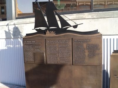
On June 28, 1839, the schooner Amistad set sail from Havana with fifty-three captive Africans: forty-nine adult males and four children, three of them girls. Four days later, in a life and death struggle for freedom, the Africans killed the . . . — — Map (db m216607) HM
English settlers were attracted to the Thames River because it offered a safe harbor and good anchorage with easy access to the sea. This quickly led to a thriving community based on coastal trade. New London colonial merchants became so . . . — — Map (db m48321) HM
On May 29, 1919, an hours-long brawl between Black and white Navy sailors erupted at the Hotel Bristol at 92 Bank Street. With five thousand people surrounding the hotel, the New London police and fire departments were unable to control the crowd . . . — — Map (db m217020) HM
In 1789, when the new federal government needed a national source of revenue, Congress turned to the sea. They placed a tax on imports, created the Customs Service to collect it and established federal oversight for lighthouses to ensure safer . . . — — Map (db m48329) HM
Just as the early settlers recognized the fine qualities of the New London harbor, so did the US Government. At the end of the Civil War, the Federal Government accepted land in Groton and Ledyard, purchased by New London, for a new naval base. . . . — — Map (db m48326) HM
Whaling has been associated with the port of New London from its earliest days, but it wasn't until the early 1800s that large scale whaling endeavors took place as an alternative to the increasingly unprofitable West Indian trade. The period . . . — — Map (db m216867) HM
Human relationship with sea mammals has evolved through the past 300 years. Oil from whales and seals was exploited, yet essential to developing our industrial revolution in the 19th century. The wealth accumulated from whaling was invested in . . . — — Map (db m48186) HM
The Revenue Cutter Service, the federal bureau that enforced treaties and tariffs on the seas and inland waterways, established its officer training school at Fort Trumbull in 1910. Fort Trumbull offered easy access to Long Island Sound, which was . . . — — Map (db m48386) HM
Slater Museum
Samuel Slater, possessing considerable knowledge of textile production and machinery emigrated from England in 1789. He was attracted to the United States because of the bounty offered here for skilled textile workers. British law . . . — — Map (db m101858) HM
Once upon a time in Norwich, the Governor of the State of Connecticut, William A. Buckingham, resided in this building. Born in Lebanon, Connecticut, May 28, 1804, he attended Lebanon School, Bacon Academy in Colchester, and later took up residency . . . — — Map (db m171812) HM
Once upon a time in Norwich…
Hopkins & Allen Gun Factory was the city’s largest employer. During the Civil War, Norwich provided more arms for the Union forces than any other city. As the nation’s largest armory, Hopkins & Allen was just one . . . — — Map (db m101882) HM
Leffingwell Inn
In 1675, Steven Backus built a simple two-room, side-chimney house. Over two centuries, it would be modified many times. Thomas Leffingwell, a founder of Norwich and friend of the Great Sachem, Uncas, bought the house in 1700 and . . . — — Map (db m101942) HM
Several species of fish live in the ocean, but must come inland to fresh water in order to reproduce. These are known as "anadromous" species. For thousands of years this life cycle was part of the aquatic ecology in North America. When Europeans . . . — — Map (db m193115) HM
You are standing above the Baltic Mill headrace — the channel that fed water to the turbines in the Baltic cotton mill. The headrace reached from the stone bulkhead, to your left, to the back of the mill, some 800 feet to your right.
The . . . — — Map (db m141431) HM
An Aquinnah Wampanoag History of a Whaling Ancestor
by Elizabeth James Perry
"The Aquinnah Wampanoag are the Indigenous people of Noepe, or Martha's Vineyard. Wampanoag men apprenticed English colonists to learn boat . . . — — Map (db m227091) HM
This large, green diesel marine engine weighs 7.5 tons and was appropriately named after the Greek god who was strong enough to carry the world on his back. It is a direct drive engine with planetary reversing gear, which means that it is able to . . . — — Map (db m227162) HM
This building was built about 1863 as the George Greenman & Co. store. The store, which sold produce and other goods to the shipyard and mill employees and nearby families until the 1880s, was located on the first floor, with living quarters for . . . — — Map (db m114846) HM
Built: 1987, Mystic Seaport Museum
Length: 20'
Beam: 10'
The Breck Marshall is a reproduction of a Cape Cod catboat as built by the Crosby family of Osterville, Massachusetts; at the end of the . . . — — Map (db m227015) HM
Paul Cuffe was the son of Ruth Moses, a Wampanoag woman, and Kofi Slocum* a man from West Africa brought to Massachusetts as an enslaved person. Kori gained his freedom, but died when Paul was young. Paul began a career at sea at the age of 14 on . . . — — Map (db m227102) HM
Americans' prevailing beliefs about humans' place in the natural world have shifted dramatically since the active whaling years of the Charles W. Morgan. A century ago most Americans saw the ocean's seemingly boundless resources solely as . . . — — Map (db m227018) HM
This house was built in 1841 for Clark and Harriet Greenman.
Clark was the second oldest of the three brothers who founded the George Greenman & Co. Shipyard. The oldest brother, George, built the house on your left in 1839. The youngest . . . — — Map (db m114826) HM
Whaling voyages created opportunities for cultural exchange between crew from all corners of the globe. Sailors used whaleships to emigrate when whaling vessels routinely stopped and picked up crew in remote places such as Valparaiso, Cape Verde, . . . — — Map (db m227049) HM
We believe this house was built in the 1840s. George Greenman & Co. rented its two apartments to employees of the company's shipyard and textile mill. In the 1850s and 1860s it was occupied by the widow of a mill employee and the minister of the . . . — — Map (db m114845) HM
How did people in Cincinnati, Ohio, get saltwater fish for their chowder in the days before refrigeration and canning? They probably bought a small box of salted, dried fish caught in the Atlantic months before.
Fishermen on the L.A. . . . — — Map (db m227129) HM
Built: 1925, John F. James & Son, Essex, MA
Length: 137'
Beam: 25'
After a century of service, the Grand Banks fishing schooner Roseway is here at Mystic Seaport Museum for a major preservation . . . — — Map (db m226931) HM
This simple single-cylinder (one-lung) engine with flywheel is typical of tens of thousands found all over rural America after their introduction in the 1890s. They powered small . . . — — Map (db m227098) HM
Feeding a Growing Nation
Between 1865 and 1930, New England fishing schooners sailed to the North Atlantic's rich fishing banks, where phytoplankton flourish in shallow waters and attract cold-water fish. The L.A. Dunton fished there . . . — — Map (db m227105) HM
Working in Extreme Conditions
The captain and crew of the Dunton faced danger every day at sea. Fishing in the North Atlantic was physically exhausting work, done in tight quarters and rough conditions. Voyages lasted between one and . . . — — Map (db m227125) HM
Part of this house was standing when brothers George, Clark, and Thomas Greenman purchased the surrounding land in 1837 and founded the George Greenman & Co. Shipyard.
They lived here until George Greenman built the house on your right in 1839. . . . — — Map (db m114834) HM
Blacksmithing and metal work has always been a much-revered occupation in West Africa and it was one of the few skilled trades open to enslaved men before emancipation. Lewis Temple was a 19th-century blacksmith and innovator who was born in . . . — — Map (db m226992) HM
Lobstermen and dealers kept lobsters alive in floating wooden crates called "cars" to await either being sent to market or sold at the right time for better prices. This car is a reproduction of the large one used by dealers around 1890. As many as . . . — — Map (db m226980) HM
Mystic Bank has been placed on the National Register of Historic Places in 2014 by the United States Department of the Interior. — — Map (db m227175) HM
Located in Pequot territory and used for millennia by Indigenous people, it was later colonized by Europeans who displaced local Indigenous peoples. Mystic is also the notorious site of one the most brutal massacres of Indigenous people in . . . — — Map (db m227055) HM
This simple shed served as the toilet for shipwrights at the shipyard established by Herbert Newbert and Leroy Wallace in 1942. the yard specialized in building fishing vessels, including the eastern-rig dragger ROANN, which is . . . — — Map (db m226974) HM
19th-century commercial whaling was a volatile, high-risk, and high-profit industry of the kind often identified as a distinctly American practice. It had a devastating impact on some of the world's whale populations and a contradictory impact on . . . — — Map (db m227017) HM
Here at Mystic Seaport Museum, we produce our own lumber from logs. It is more economical and provides us with the correct moisture content and unusual sizes we need. White oak, yellow and white pine, spruce, fir, and hackmatack are all used in . . . — — Map (db m227156) HM
The shipsaw is a type of bandsaw. The blade is a thin steel band that is turned at a high rate of speed by large wheels. Most bandsaws have a table that tilts to change the angle of the cut. This is convenient if the piece of wood is small enough . . . — — Map (db m227146) HM
Built and launched in New Bedford in 1841, the Charles W. Morgan is the last of an American whaling fleet that numbered more than 2,700 vessels over 150 years. During an 80-year whaling career, the Morgan embarked on 37 voyages. . . . — — Map (db m227038) HM
During the era of slavery, African Americans played a major role in oystering. Thomas Downing, a notable abolitionist who was the "Oyster King" of New York City, built an empire out of an oyster bar. He made his fortune in oysters as an . . . — — Map (db m226979) HM
This house was built in 1842 for Thomas and Charlotte Greenman. Thomas was the youngest of the three brothers who founded the George Greenman & Co. Shipyard. The oldest brother, George, built the house two doors to your left in 1839. The middle . . . — — Map (db m114807) HM
"The water brought us here: the water will take us home" - Ebo Tribesman
West Africa is the home of ancient maritime traditions. West Africans built and used boats for fishing, transportation, trade, . . . — — Map (db m227089) HM
Whaleboats were an essential piece of equipment for a ship like the Charles M. Morgan. When a whale was spotted, the whaleboats would be lowered into the . . . — — Map (db m227016) HM
This house was built in the early 1850s by William Haynes (1820-1905), a ship carpenter who often worked at the George Greenman & Co. Shipyard. The small room on the left side is a later addition, and the bay window was added in the mid-1900s . . . — — Map (db m114844) HM
The Historic Mills Mural celebrates the rich manufacturing history of Pawcutuck, CT. Local ship building, printing press, and textile manufacturing built multiple mills to take advantage of the powerful Pawcutuck River and its easy connectivity to . . . — — Map (db m226902) HM
This intersection for many years was the site of the Andover Creamery Company, an enterprise started in 1886 by a group of 76 Andover residents. The idea was to provide local farmers with a better way to market their butter. Up until that time, . . . — — Map (db m207624) HM
Formally known as Hanover or Hartford Mountains, this town was incorporated in 1720, having been settled by a group of “good Christian men” desiring more open farmland.
In 1781 the French army of General Rochambeau, on their way to aid the army . . . — — Map (db m140602) HM
Side 1
This land was known to the Indians as Wonggumbaug – “crooked pond” from the curved shape of the large body of water within the present town limits. It was set off in 1706 to be divided by deedholders from . . . — — Map (db m140597) HM
A mill complex, consisting of 15 buildings, existed at this site which reprocessed used fabrics for the production of inexpensive woolen cloth.
The stone ruins and two nearby brick buildings are all that remains of this complex. — — Map (db m142387) HM
John Boynton began his career in the early 1800s and became the dominant businessman in town for the next 45 years. He purchased this site known as the ‘still’ lot and in 1815 at age 35, built the mill building seen here today.
The upper . . . — — Map (db m158734) HM
Prior to 1800 the area of Coventry Village was dominated by three large farms, the First Church and ministry, and the Nathan Hale Cemetery. Thomas Porter and later his son Noah, owned the land from the lake dam southeast to today’s Mason Street. . . . — — Map (db m142179) HM
Prior to 1800 the area of Coventry Village was dominated by three large farms, the First Church and ministry, and the Nathan Hale Cemetery. Thomas Porter and later his son Noah, owned the land from the lake dam southeast to today’s Mason Street. . . . — — Map (db m142403) HM
The Bidwell House
This Greek revival style hotel was built in 1822 by Solomon Bidwell on a one hundred forty acre track of land. The ell was added by Solomon's son, Lyman Bidwell, around 1850. The property descended to Lyman's son and daughter . . . — — Map (db m142436) HM
The history of this mill site started in April of 1812 when Fitch, McClean and Gilbert built a paper mill “five rods south of the grist mill.” The purity of the water was noted for making writing and accounting paper. In 1820 the mill . . . — — Map (db m142569) HM
The Washburn Mill
Behind and to the west of the Visitors' Center was the Washburn foundry and silk mill which operated from 1841 to 1908. There are no existing pictures of the mill, though a survey map (see insert) exists. from 1908. The site . . . — — Map (db m142427) HM
Thomas H. Wood’s Silk Mill
This mill site has been in continuous commercial operation since 1716. That year the town fathers commissioned Jonathan Hartshorn to build a mill at the brook. The small grist mill, serving at first about forty families . . . — — Map (db m142426) HM
Wellwood’s General Store
On this site sits the oldest standing General Store building in the nation. The first building at this location (1787) housed the store and small living quarters that is now part of the adjoining residence. not much of the . . . — — Map (db m142429) HM
The American Mill was originally the site of a saw and grist mill owned by Rufus West and Horace Vinton. In 1846, Phineas Talcott purchased the site, and in 1847, he and Nelson Kingsbury organized the American Mills Company and constructed a new . . . — — Map (db m230439) HM
Fitch Mill, Belding Silk Mills & Dart's Stone Mill
In the late 1700s, the terrain at this corner was a wilderness, with ancient hemlocks growing on steep ledges overhanging the river. The Hockanum River tumbled out of Snipsic Lake, and down a . . . — — Map (db m111816) HM
In 1720 a party of eight men, originally from England, bought sixteen thousand acres in this region and called it Wellington. One of these, Roger Wolcott, subsequently became governor of Connecticut (1750–1754).
After a century of farming . . . — — Map (db m1622) HM
Front Settled in 1700 and incorporated in 1708, Killingly was the forty-second town established in Connecticut.
In 1653, the second John Winthrop obtained a grant of a large tract of land formerly held by the Quinebaug Indian tribe and . . . — — Map (db m93380) HM
On this site, Benjamin Cargill operated a grist mill
originally built in 1730, adding a distillery and other
shops in 1760. The Pomfret Manufacturing Company
later built the Pomfret Cotton Mills to produce textile
products in 1807; it is the . . . — — Map (db m126039) HM
Originally part of the long narrow area called Voluntown, this northern section separated and obtained town privileges from the Connecticut General Assembly on the second Thursday of May, 1794. The name given was that of a temporary resident, Dr. . . . — — Map (db m140730) HM
The intersection of two turnpikes
brought about the growth of this
settlement known for many years as
Village Corners. The Norwich and
Woodstock Turnpike began in 1801 to
carry traffic northward to the
Massachusetts line. About 1827 . . . — — Map (db m123732) HM
Front The industry of northeastern
Connecticut had its earliest
beginnings in this area, Soon
after arriving in 1686 the early
settlers built a sawmill on a
small brook running into the
“Great Lake.” Later several . . . — — Map (db m123797) HM
282 entries matched your criteria. Entries 201 through 282 are listed above. ⊲ Previous 100