Near Meadow Road Northeast, 0.1 miles east of Eagle Nest Road Northeast, on the left when traveling west.
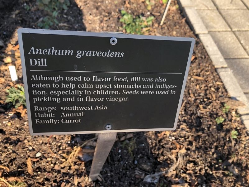
Although used to flavor food, dill was also eaten to help calm upset stomachs and indigestion, especially in children. Seeds were used in pickling and to flavor vinegar. — — Map (db m144643) HM
Near Meadow Road Northeast, 0.1 miles east of Eagle Nest Road Northeast, on the left when traveling west.
Native Americans used the stalk for fiber in the same way Europeans used their hemp plant, Cannabis sativa. Indian Hemp is superior, however, because it is stronger and lasts longer.
This herb is poisonous. — — Map (db m144567) HM
Near Meadow Road Northeast, 0.1 miles west of Eagle Nest Road Northeast, on the left when traveling west.
Artemisia abrotanum hung in courtrooms was thought to stop the spread of disease. It was also used in kitchens to keep bad odors away. Pennsylvania Germans used southernwood in their pantries to repel ants. — — Map (db m145047) HM
Near Meadow Road Northeast east of Eagle Nest Road Northeast, on the right when traveling east.
Wormwood is a main ingredient in the controversial liqueur absinthe, which was banned for many years because of its supposed mind-altering effects. This reputation was attributed to thujone, a chemical found in wormwood, but original absinthe . . . — — Map (db m235689) HM
Near Meadow Road Northeast, 0.1 miles east of Eagle Nest Road Northeast, on the left when traveling west.
The juice, mixed with oil, stopped earaches and destroyed nasal polyps. It was also used to treat certain cancers and abortion. Drunk with wine, it was an aphrodisiac. The plant is injurious. — — Map (db m144661) HM
Near Meadow Road Northeast, 0.1 miles east of Eagle Nest Road Northeast, on the left when traveling west.
The Cherokee used the leaves and woody stems to make a blue dye. The Mohegan bathed their cuts and wounds with an infusion of the plant. This entire herb is toxic. — — Map (db m144568) HM
Near Meadow Road Northeast, 0.1 miles east of Eagle Nest Road Northeast, on the left when traveling west.
Brought to America by the first colonists, pot marigolds were used to flavor and color stews and cheeses. The Plymouth colony also used the flowers to dye cloth. — — Map (db m144640) HM
Near Meadow Road Northeast, 0.1 miles east of Eagle Nest Road Northeast, on the left when traveling west.
The yellow dye from the fresh or dried petals was commonly used to color butter, cheeses and puddings. The petals were also used in ancient Rome as a substitute for the more expensive saffron in coloring soups, syrups and conserves. — — Map (db m144648) HM
Near Meadow Road Northeast, 0.1 miles west of Ellipse Road Northeast, on the left when traveling west.
During the U.S. Civil War, Confederate soldiers used roasted, ground chicory root as a substitute for coffee, which was scarce during the conflict. Still popular in the southern states, chicory is either mixed with true coffee or prepared by itself. . . . — — Map (db m144436) HM
On Meadow Road Northeast just east of Eagle Nest Road Northeast, on the right when traveling east.
Bergamot's rind releases a highly fragrant essential oil that was used in perfumery as early as the 18 century in Cologne, Germany, where it was a key component of the original Eau de Cologne. It also lends its distinctive scent to . . . — — Map (db m207111) HM
Near Meadow Road Northeast, 0.1 miles west of Ellipse Road Northeast, on the left when traveling west.
The Cherokee used the wood of this tree for building and carving. Early settlers in the southern Appalachians used the root bark for dye and the yellow heartwood for gunstocks. Today, yellowwood is popular in urban settings for its resistance to . . . — — Map (db m144694) HM
Near Meadow Road Northeast, 0.1 miles east of Eagle Nest Road Northeast, on the left when traveling west.
The stigmas are used in yellow food coloring and flavoring. Chemical analysis of ancient linens and mummies' winding sheets confirms its use as a dye. Today, it is used more as a spice and in cosmetics than as a textile dye. — — Map (db m144652) HM
Near Meadow Road Northeast just east of Eagle Nest Road Northeast, on the right when traveling east.
The flower petals contain a very strong dye, which on wool yields colors ranging from yellow and bronze to red, depending on the mordant and length of time simmered. Wild mountain dahlias were a source of red dye used by the Aztecs. — — Map (db m207114) HM
Near Eagle Nest Road Northeast, 0.1 miles south of Meadow Road Northeast, on the left when traveling south.
The flowers have a sweet, clove-like scent and were used by Greeks and Romans in the making of coronets and garlands. In medieval Arabia, they were used in perfumes. An absolute, a refined form of the essential oil, is used in top-quality perfumes . . . — — Map (db m144689) HM
Near Meadow Road Northeast, 0.1 miles east of Eagle Nest Road Northeast, on the left when traveling west.
In Dioscordes' time the young leaves of this prickly plant were pickled in brine and eaten as a pot herb. A drink of 'Eryngum' root diluted in honey liquor was said to cure epilepsy. — — Map (db m144654) HM
Near Meadow Road Northeast, 0.1 miles east of Eagle Nest Road Northeast, on the left when traveling west.
The roots produce reds similar to madder (Rubia tinctorum), although they are thin and yield less pigment than the thicker madder roots. The seeds of this plant were imported from France by Thomas Jefferson. — — Map (db m144649) HM
Near Meadow Road Northeast east of Eagle Nest Road Northeast, on the left when traveling west.
The colonists used this plant to obtain a yellow-green dye from its flowers. The leaves, seeds and flowering plant were also used medically as a diuretic and purgative. — — Map (db m144557) HM
Near Meadow Road Northeast east of Eagle Nest Road Northeast, on the right when traveling east.
Barley is believed to be the first grain used for fermenting into beer. Due to its high levels of starch-converting enzymes and its tolerance of drought, cold, and poor soil conditions, barley is considered to be a distiller's "best friend". It is . . . — — Map (db m235684) HM
Near Eagle Nest Road Northeast, 0.1 miles south of Meadow Road Northeast, on the left when traveling south.
Native American medicinal uses of the root included treatment of the eyes and skin and for cancers and venereal diseases. The yellow root provided dye.
This plant should be avoided during pregnancy. — — Map (db m144572) HM
Near Meadow Road Northeast, 0.1 miles east of Eagle Nest Road Northeast, on the left when traveling west.
Fragments of indigo-dyed linen from Thebes date back to 3500 B.C. Indigo is just one type of dye in which the color develops in the textile after removal from the dye bath. Upon exposure to the air, fibers change from yellow to blue. — — Map (db m144645) HM
Near Meadow Road Northeast east of Eagle Nest Road Northeast, on the right when traveling east.
Juniper berries flavor gin, liqueurs, cordials and soft drinks. The roasted berries were once used as a coffee substitute. In France the berries are fermented with barley to make a beer called genevrette. — — Map (db m235688) HM
Near Meadow Road Northeast, 0.1 miles east of Eagle Nest Road Northeast, on the left when traveling west.
The scent of lavender was much loved, and the flowers were dried and used in linens, in wash water, soaps, oils and powdered. The fragrance warded off evil smells of poor drainage and lack of sanitation. — — Map (db m144679) HM
Near Eagle Nest Road Northeast, 0.1 miles south of Meadow Road Northeast, on the left when traveling south.
These flowers have spicy scent similar to Dianthus, and the fragrance grows stronger at night. They are used in bouquets and potpourri, and the scent was used in early Arab and Greek perfumes. — — Map (db m144691) HM
Near Meadow Road Northeast, 0.1 miles east of Eagle Nest Road Northeast, on the left when traveling west.
Although most commonly used by the colonists to flavor food and drink, mint was also used to whiten teeth, prevent milk from curdling and to strew on floors to repel bad smells and insects. — — Map (db m144639) HM
Near Meadow Road Northeast east of Eagle Nest Road Northeast, on the right when traveling east.
Mint was once a popular strewing herb in Italian churches. Several mints yield useful essential oils, and the dried leaves are added to potpourri. Peppermint and spearmint are used in perfumery as well as to scent soaps and toothpastes. — — Map (db m235693) HM
Near Meadow Road Northeast, 0.1 miles east of Eagle Nest Road Northeast, on the left when traveling west.
This versatile herb was used by colonists to alleviate toothaches, flavor food and strew on floors, as well as flavor ale. The flowering tops were used to produce a reddish brown dye. — — Map (db m144633) HM
Near Eagle Nest Road Northeast, 0.1 miles south of Meadow Road Northeast, on the left when traveling south.
The leaves are steam distilled to produce an oil that has a spicy, aromatic scent. The early Greeks, Egyptians, and Arabs all used it in their perfumes. Today, it appears in many perfumes and soaps, especially men's fragrances. The leaves and . . . — — Map (db m144686) HM
Near Meadow Road Northeast, 0.1 miles east of Eagle Nest Road Northeast, on the left when traveling west.
Native Americans made use of poke berries as a body paint. Later the Colonists found it an inexpensive source of red dye for woolens. Young leaves yield brilliant yellows on wool.
Caution: poisonous — — Map (db m144660) HM
Near Meadow Road Northeast east of Eagle Nest Road Northeast, on the right when traveling east.
The flowers are highly fragrant and are used in the production of perfumes. The common name, "frangipani," is derived from an Italian noble family which invented a plumeria-scented perfume in the sixteenth family. The flowers themselves are strung . . . — — Map (db m235692) HM
Near Eagle Nest Road Northeast, 0.1 miles south of Meadow Road Northeast, on the left when traveling south.
Rosemary has an ancient history in the Mediterranean as an incense and perfume. It was the main ingredient in Hungary Water, one of the earliest European perfumes created for the Queen of Hungary in A.D. 1370. The scent became popular throughout . . . — — Map (db m144437) HM
Near Meadow Road Northeast, 0.1 miles east of Eagle Nest Road Northeast, on the left when traveling west.
Rosemary was a favorite herb for cooking and strewing. As a symbol of remembrance and fidelity, it was added to wedding cakes and puddings, as well as tossed into coffins at funerals. — — Map (db m144636) HM
Near Meadow Road Northeast, 0.1 miles west of Ellipse Road Northeast, on the left when traveling west.
Rosemary contains several volatile oils, tannins, bittering compounds, and resins, which are thought to contribute to the increased potency and extended preservation of beers brewed with it. It has been used medicinally for centuries to improve . . . — — Map (db m144695) HM
Near Meadow Road Northeast, 0.1 miles east of Eagle Nest Road Northeast, on the left when traveling west.
Having been used since at least 2000 B.C., the reddish orange roots contain several dye substances. It was used to dye the British redcoats and was best known as the source of Turkey red on linen and cotton textiles. — — Map (db m144650) HM
Near Meadow Road Northeast east of Eagle Nest Road Northeast, on the right when traveling east.
This grass has been a source of sugar for at least 5,000 years, and sugar was the original sweetener of choice in the beverage industry. Cane juice, molasses, and falernum syrup are all made from this plant, and are used in the brewing of stouts or . . . — — Map (db m235690) HM
Near Meadow Road Northeast, 0.1 miles east of Eagle Nest Road Northeast, on the left when traveling west.
Colonists brought winter savory over to the new world to flavor dishes, stuffings to meat, fish and sausages. Leaves were taken to stimulate the appetite and to aid in digestion. — — Map (db m144634) HM
Near Meadow Road Northeast just east of Eagle Nest Road Northeast, on the right when traveling east.
The leaves and stems have long been an excellent source of a yellow dye that has been popular with dyers since Colonial days. The Navajo Indians used it as a textile dye. Colors produced range from yellows to greens. — — Map (db m207117) HM
Near Meadow Road Northeast just east of Eagle Nest Road Northeast, on the right when traveling east.
Marigolds are thought to have been taken to Europe from the New World by Cortez. The flowers contain the same dye substances as onion skins. A variety of colors are imparted to wool depending on the mordant. — — Map (db m207115) HM
Near Meadow Road Northeast, 0.1 miles east of Eagle Nest Road Northeast, on the left when traveling west.
This plant was used by the colonists in a favorite spring tonic known as "Sweet Mary tea." It was also widely used throughout eastern Massachusetts in nosegays or as bookmarkers to enjoy during long sermons. — — Map (db m144637) HM
On Meadow Road Northeast just east of Eagle Nest Road Northeast, on the left when traveling west.
Tansy tea was taken to calm cramps, but colonists also used tansy leaves as an insect repellant in their homes. Leaves were also rubbed on fresh meats to keep flies off. — — Map (db m144559) HM
Near Eagle Nest Road Northeast, 0.1 miles south of Meadow Road Northeast, on the left when traveling south.
Tradition says the Pied Piper carried valerian root in his back pocket to help lure the rats out of Hamelin. The root has an offensive scent similar to Limburger cheese, but is also musky and balsamic and is used in perfumery in India and the Far . . . — — Map (db m144690) HM
Near Meadow Road Northeast, 0.1 miles east of Eagle Nest Road Northeast, on the left when traveling west.
The Native Americans had been using the leaves since time immemorial to make twine and cordage. Men on Raleigh's second voyage to Virginia in 1586 noticed its economic potential. — — Map (db m144564) HM
On H Street Northeast at 8th Street Northeast, on the right when traveling west on H Street Northeast.
One year before Congress and the President arrived in their new capital city in 1800, Washington's Navy Yard opened at the foot of Eighth Street, two miles south of this sign. The yard soon became the city's biggest employer. In 1908 . . . — — Map (db m71680) HM
On Florida Avenue Northeast at 10th Street Northeast, on the right when traveling east on Florida Avenue Northeast.
The Trinidad neighborhood, named for W.W. Corcoran's original estate, got its start in the 1890s after the Washington Brick Machine Company used up the clay here making bricks. With H Street filling in with houses and businesses, the company . . . — — Map (db m186807) HM
On H Street Northeast at 4th Street Northeast, on the right when traveling east on H Street Northeast.
Cathy Hughes and WOL-AM have made an indelible mark on this Washington D.C. community. In 1982, Hughes purchased a building at the corner of 4th and H Streets and found it littered with almost 200 hypodermic needles and crack pipes. The home of her . . . — — Map (db m111969) HM
On H Street Northeast at 13th Street Northeast, on the right when traveling west on H Street Northeast.
When the Atlas Performing Arts Center opened in 2005, it gave hope to an area still recovering from the destruction following the assassination of the Reverend Dr. Martin Luther King, Jr., in 1968. But when K-B's Atlas movie house opened here . . . — — Map (db m152470) HM
On H Street Northeast west of 13th Street Northeast, on the right when traveling west.
Dr. Granville N. Moore practiced medicine on this site for over 50 years, providing medical care for the poor and underprivilege.
In the spirit of Dr. Granville's commitment to the community, we reopen these doors as a . . . — — Map (db m244968) HM
On H Street Northeast at 13th Street Northeast, on the right when traveling east on H Street Northeast.
The small scale and low rents of H Street's oldest buildings have lured waves of immigrant entrepreneurs since the buildings were new in the 1880s. By 1930, alongside Greek, Italian, Irish, and other immigrant-owned shops, at least 75 . . . — — Map (db m71690) HM
On H Street Northeast at 7th Street Northeast, on the right when traveling east on H Street Northeast.
Ourisman Chevrolet once occupied almost the entire north side of this block. After two years as a top-performing Chevy salesman on Connecticut Avenue, and with a $2,000 loan from his widowed mother, Benjamin Ourisman opened his own dealership . . . — — Map (db m71693) HM
On Maryland Avenue Northeast at G Street Northeast, on the right when traveling west on Maryland Avenue Northeast.
Maryland Avenue in the 1930s was home to immigrants from around the Mediterranean. Evelyn Kogok Hier grew up at 1328 Maryland Avenue. She remembered her next-door neighbor, the Right Reverend Ayoub (Job) Salloom, hosting after-church gatherings . . . — — Map (db m152471) HM
On H Street Northeast at Maryland Avenue Northeast (U.S. 1), on the right when traveling east on H Street Northeast.
The starburst intersection of five major roads marks this spot as a transportation hub for the neighborhood and the region. Shortly after Congress arrived in Washington in 1800, city leaders chose an old farm road to create a private toll . . . — — Map (db m71688) HM
On Franklin Street Northeast at Reed Street Northeast, on the right when traveling west on Franklin Street Northeast.
Stone Straw Building circa 1931; site of the development of the paper drinking straw and other wound paper products by Marvin C. Stone, inventor of the paper straw. (c.1888) On this site was developed the automated equipment and manufacturing . . . — — Map (db m144339) HM
Near Maryland Avenue Northeast (Alternate U.S. 1) at 3rd Street Northeast.
This residence was designed by architect Appleton P. Clark, Jr. and built in 1891 for Daniel Birtwell. In 1900, George Bruce Cortelyou occupied the house when he became secretary to President McKinley. Cortelyou continued to serve in public office . . . — — Map (db m69292) HM
On 11th Street Northeast south of C Street Northeast, on the left when traveling south.
Designed 1916
in Moorish Revival Style
Architect
William S. Plager
(1860-1946)
Photo: circa 1926
Goode Collection
Library of Congress
Redesigned 1941
in Art Deco Style
Architect
Mihran Mesrobian . . . — — Map (db m134068) HM
On 9th Street Northeast at A Street Northeast, on the right when traveling south on 9th Street Northeast.
Dedicated in memory of
Lola Beaver
1910 - 2006
Human and Animal Rights Advocate
Seamstress, Dancer, Choreographer
Owner - the Costume Studio
🎭
Established by D.C. Council as
"Lola Beaver Memorial Park" . . . — — Map (db m230703) HM
On F Street Northeast at 3rd Street Northeast, on the right when traveling east on F Street Northeast.
Stuart-Hobson Middle School, one block to the east of this sign, was built in 1927 on the site of an old brewery, one of nearly two dozen that operated in DC after the Civil War. Almost all of the breweries were run by German immigrants who . . . — — Map (db m71681) HM
On Nannie Helen Burroughs Avenue Northeast at Division Avenue Northeast, on the left when traveling north on Nannie Helen Burroughs Avenue Northeast. Reported missing.
The Two-Story Art Deco Style Building on your left was once the Strand Theater. Abe Lichtman, a Jewish businessman whose movie theaters catered to black patrons, opened the Strand in 1918. Lichtman also operated the Lincoln and Howard . . . — — Map (db m130777) HM
On Sheriff Road Northeast at 46th Street Northeast, on the right when traveling west on Sheriff Road Northeast.
Sheltered from the overt bigotry many African Americans experienced when venturing downtown, Deanwood shoppers of the 1950s patronized Sheriff Road's mostly African American businesses, including Mouse Gordon's tailor shop, Tip Top Grocery, . . . — — Map (db m130783) HM
On Harry Thomas Way Northeast south of Quincy Lane Northeast, on the right when traveling north.
Alethia Tanner, or "Lethe" as she was known, was born into slavery in 1781 on a plantation in Prince George's County, Maryland, where she lived and worked with her sisters, Laurana and Sophia, before coming to Washington in the early 1800s. . . . — — Map (db m234910) HM
Near Harry Thomas Way Northeast south of Quincy Lane Northeast, on the right when traveling north.
Growing A Healthy Park
For most of the 20th century, the land around you was a rail yard connecting the District to the world, after which it lay mostly fallow, a place for parking cars and dumping trash. Although these industrial uses . . . — — Map (db m234909) HM
On Harry Thomas Way Northeast at Q Street Northeast, on the right when traveling north on Harry Thomas Way Northeast.
The Plantation
Alethia Tanner and her sisters worked alongside other enslaved workers on the Chelsea Plantation in Upper Marlboro, Maryland. It was owned by Tobias Belt and later by his daughter, Rachel Belt Pratt.
When Tobias Belt . . . — — Map (db m234912) HM
On 6th Street Northeast at Neal Place Northeast, on the right when traveling south on 6th Street Northeast.
Successful entrepreneurs get in the ring to fight for their businesses and communities every day. "Entrepreneurship is a Boxing Match," inspired by a poem by Shelly Olimâdè Bell, founder & CEO of Black Girl Ventures Foundation (BGV), highlights . . . — — Map (db m202317) HM
On Florida Avenue Northeast at 5th Street Northeast, on the right when traveling west on Florida Avenue Northeast.
This high ground near the B&O Railroad tracks has been Union Terminal Market since 1931. That year Center Market on Pennsylvania Avenue, NW, came down to make way for the National Archives. Vendors seeking new locations clustered here. . . . — — Map (db m71684) HM
On Nannie Helen Burroughs Boulevard Northeast at 50th Street Northeast, on the right when traveling east on Nannie Helen Burroughs Boulevard Northeast.
Atop this hill are the sprawling grounds on which Nannie Helen Burroughs (1879-1961) founded the National Training School for Women and Girls in 1909. Burroughs was an outspoken advocate for women's rights, civil rights, and religious . . . — — Map (db m184992) HM
On River Trail Northeast just west of Anacostia Avenue Northeast.
"Beauty cannot be purchased, it must be created."
— Helen Shaw Fowler
Welcome to these aquatic gardens—transcend the busy streets and embrace the unique beauty, peace and natural rhythm to be found here.
The . . . — — Map (db m145317) HM
Near Anacostia Avenue Northeast, 0.1 miles west of Ponds Street Northeast, on the right when traveling west.
Marketing a wide variety of aquatic plants, especially tropical lilies, contributed to the success of Shaw Gardens. The concrete display pools, also referred to as display ponds, installed between 1912 and 1927, played a crucial role in boosting . . . — — Map (db m141730) HM
On Anacostia Avenue Northeast just west of Ponds Street Northeast, on the right when traveling west.
Helen Fowler took over administration of the Shaw Gardens from her father in 1912. Under her guidance the gardens grew into one of the most extensive water plant businesses in the nation. By 1938, Shaw Gardens encompassed 42 ponds spread over nine . . . — — Map (db m141717) HM
On Minnesota Avenue Northeast at Grant Street Northeast, on the left when traveling south on Minnesota Avenue Northeast.
Formerly known as the Bladensburg Piscataway Road, Minnesota Avenue has long served as an eastern gateway into Washington. Since the original wooden Benning Road Bridge across the Anacostia River was erected nearby in 1800, countless people . . . — — Map (db m136184) HM
Near Meadow Run Northeast just west of Ellipse Road Northeast, on the right when traveling west.
Penjing master and collector Yee-sun Wu founded an grew a billion dollar Hong Kong bank on his own, but he owed his success with penjing to his Chinese father and grandfather. They taught him to use the techniques of the "clip and grow" method of . . . — — Map (db m207094) HM
On 3rd Street Northeast south of N Street Northeast, on the left when traveling north.
This mural celebrates the industrial history at this site as the former Central Armature Works as it soars into its next incarnation.
Electricity/energy converts to motion - this wind carries the spirit of dreams, invention, collective work, . . . — — Map (db m236341) HM
On N Street Northeast just east of New York Avenue Northeast (U.S. 50), on the left when traveling east.
Evoking NoMa's character as a transportation hub for goods and people, as well as its adjacency to the wholesale food market at Union Market Terminal, this sculpture also reminds us of the philosophical paradox around creation and transformation. . . . — — Map (db m142455) HM
On 13th Street Northwest south of Crittenden Street Northwest, on the right when traveling north.
This tree was planted in honor of the founder and pioneers of this community with a special tribute to Ms. Minnie Terrell who provided the name,
"The Duncan Co-Op"
Founder
Coye "Frank" McAllister
Pioneers
Ann Simpson-Mason* . . . — — Map (db m216830) HM
On Georgia Avenue Northwest (U.S. 29) south of Missouri Avenue Northwest, on the right when traveling south. Reported missing.
English, Irish and German settlers, as well as enslaved and free African Americans, were the first non-natives to claim Brightwood. Farmers dominated until the Civil War. Then in the 1890s electric streetcars allowed government workers to live . . . — — Map (db m121018) HM
On Georgia Avenue Northwest (U.S. 29) north of Madison Street Northwest, on the right when traveling south. Reported missing.
The City Park across the street was once Emery Place, the summer estate of Matthew Gault Emery.
A prominent builder, Emery was Washington City's last elected mayor during the period of home rule. He was succeeded in 1874 by a . . . — — Map (db m72816) HM
On 16th Street Northwest at Colorado Avenue Northwest, on the right when traveling north on 16th Street Northwest.
Fresh Water Springs in this pleasant high ground once drew European settlers. Farmers called the area "Crystal Spring." In 1859 the half-mile Crystal Spring Racetrack opened on land to your left. For 75 cents, Washingtonians hopped a . . . — — Map (db m109288) HM
On 16th Street Northwest south of Fuller Street Northwest, on the right when traveling south.
A legendary figure of 'Solidarity' - the socio-political movement that initiated the fall of communism in Europe. One of the 100 women who defined the last century, according to the American newsweekly Time.
She worked hard her whole . . . — — Map (db m200391) HM
On 16th Street Northwest at Fuller Street Northwest, on the right when traveling south on 16th Street Northwest. Reported permanently removed.
Jacek Bogucki continued to document the subsequent Canoandes expeditions. He eventually settled down in Casper, Wyoming where he established a video production company and lives there with his wife and their son.
Zbigniew Bzdak would . . . — — Map (db m190157) HM
On 16th Street Northwest just south of Fuller Street Northwest, on the right when traveling south. Reported permanently removed.
The first crossing of the Colca Canyon became not only an important achievement in the history of exploration, but also opened up the canyon and its beauty to the world. This, in turn, contributed to the acceleration of the economic and social . . . — — Map (db m190156) HM
On 16th Street Northwest just south of Fuller Street Northwest, on the right when traveling south.
The inventor of the kerosene lamp.
The founder of the world's first oil mine and refinery.
A revolutionist and social activist who financed roads, hospitals and social welfare homes. — — Map (db m210080) HM
On 16th Street Northwest at Fuller Street Northwest, on the right when traveling south on 16th Street Northwest.
The inventor of the metal allow that revolutionized the railroad.
The author of the method of obtaining silicon crystals that made the development of electronics possible.
A philanthropist and patron of the arts, he financed the . . . — — Map (db m210088) HM
On 16th Street Northwest south of Fuller Street Northwest, on the right when traveling south.
Since 1924 this mansion has housed representatives of the Republic of Lithuania, even during the 50 years when the country was occupied by the Soviet Union.
In the late 1700s, the Russian Empire annexed Lithuania's territory, ending the . . . — — Map (db m82751) HM
On 17th Street Northwest just south of Fuller Street, on the right when traveling south.
The Ontario Theatre played a notable role in the history of the Adams Morgan neighborhood. Built for the K-B theater chain in 1951 in a contemporary Modern style, the Ontario began operations as an upscale first-run movie house, hosting local . . . — — Map (db m189086) HM
On Calvert Street Northwest at 20th Street Northwest, on the right when traveling west on Calvert Street Northwest.
The African American and Quaker cemeteries here were almost lost to time. Both closed in 1890 due to development. Parts of the land were sold to the National Zoo and National Park Service. Developers bought the rest and tried . . . — — Map (db m236780) HM
On Columbia Road Northwest north of Euclid Street Northwest, on the right when traveling south.
Furs by Gartenhaus and truffles by Avignon Freres. Hand-crafted ice cream from Budd's. Beginning in the 1910s, such neighborhood favorites occupied the commercial buildings to your right developed by Sanner and Barr. These fashionable shops . . . — — Map (db m130708) HM
On Adams Mill Road Northwest north of Columbia Road Northwest, on the right when traveling west.
Before there was "Adams Morgan," this crossroads lent the neighborhood its name: "18th and Columbia." Here you could catch a streetcar to just about anywhere and buy nearly anything.
But back in 1922, 18th and Columbia witnessed a tragedy. . . . — — Map (db m130711) HM
On 17th Street Northwest at Columbia Road Northwest, on the left when traveling south on 17th Street Northwest.
[Marker depicts individuals in historical fashion styles in DC from the 19th and 20th centuries.]
Elizabeth Keckley
Dressmaker
1818, Dinwiddie, VA ~ 1907, Washington, DC
"Art still has . . . — — Map (db m163274) HM
On Wisconsin Avenue Northwest north of Albemarle Street Northwest, on the left when traveling north.
Suburban shopping arrived in Tenleytown when Sears, Roebuck & Co. erected a Moderne style store here in 1941. The sleek façade demonstrated the latest in department store design.
Sears was the second Tenleytown business — after Giant . . . — — Map (db m130918) HM
On River Road Northwest at Wisconsin Avenue Northwest, on the right when traveling west on River Road Northwest.
Even before the nation's capital was sketched out in 1791, this spot, where River Road met the Georgetown-Frederick Road, attracted activity. John Tennally opened a tavern and inn across River Road from this sign. By the early 1800s, a hamlet . . . — — Map (db m184984) HM
On Brandywine Street Northwest at 44th Street Northwest, on the right when traveling east on Brandywine Street Northwest.
In the 1700s and 1800s Tenleytown's origin as a crossroad generated numerous commercial activities, such as tobacco trade, farms, dairies, and slaughterhouses, along with the "Tennallytown" Tavern. Murdock Mill Road led from Tenleytown to an early . . . — — Map (db m112178) HM
On Brandywine Street Northwest at 43rd Place Northwest on Brandywine Street Northwest. Reported damaged.
As an early country village, Tenleytown inhabitants held occupations such as farmers, millers, tavern owners and shopkeepers. Since horses provided the primary method of transportation until the early 1900s, blacksmithing was a popular occupation in . . . — — Map (db m112179) HM
On Chesapeake Street Northwest at River Road Northwest, on the right when traveling west on Chesapeake Street Northwest.
By 1900, 12 large families — often intermarried — came to dominate the village that was Tennallytown: the Burrows, Chappell, Harry, Hurdle, Paxton, Perna, Poore, Queen, Riley, Robey, Shoemaker, and Walther clans.
This is Harry country, . . . — — Map (db m184982) HM
On 42nd Street Northwest at River Road Northwest, on the left when traveling north on 42nd Street Northwest.
You are standing on the west side of Mt. Airy, a subdivision spanning Wisconsin Avenue laid out in the late 1890s. Mt. Airy evolved into a dense, working-class neighborhood, where policemen and dairymen lived in modest houses.
Among them . . . — — Map (db m130926) HM
On V Street Northwest at 1st Street Northwest, on the right when traveling east on V Street Northwest.
You are standing in the heart of Bloomingdale. Noted DC developer Harry Wardman, responsible for 180 Bloomingdale houses, was one of many builders who built here between 1890 and 1910.
These Victorian rowhouses were designed for . . . — — Map (db m130827) HM
On Bryant Street Northwest west of 1st Street Northwest, on the left when traveling east.
In the 1940s, homeowners in the 100 block of Bryant Street breached a contract when they sold their houses to African Americans. Covenants, or agreements, in their real estate deeds prohibited "the sale of the house to anyone of the Negro . . . — — Map (db m130828) HM
On T Street Northwest at 1st Street Northwest, on the left when traveling east on T Street Northwest.
This busy stretch of Rhode Island Avenue was a racial dividing line even as DC became majority African American in 1957. "African Americans were not welcome on [the north] side of the street," commented Reverend Bobby Livingston years later, . . . — — Map (db m130840) HM
On Georgia Avenue Northwest (U.S. 29) at Peabody Street Northwest, on the left when traveling north on Georgia Avenue Northwest.
The Large Structure across Georgia Avenue opened in 1909 as a "car barn" for the Brightwood Railway. The facility could service more than 40 streetcars at once, and often did so late at night. As a young boy in the 1950s, Thomas Reardon . . . — — Map (db m72831) HM
430 entries matched your criteria. The first 100 are listed above. Next 100 ⊳