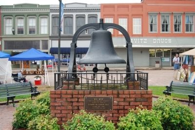
On Court Square (State Highway 20), in the median.
South:
Ship's Anchor
1861-1865
"The world shall yet decide,
In truth's clear, far-off light,
That the soldiers who wore the gray, and died
With Lee were in the right!"
----------
"Brave men may die - right has no . . . — — Map (db m171618) WM
On Court Square (State Highway 28) south of Washington Street (State Highway 203), on the right when traveling north.
Abbeville's 6th courthouse - designed in beaux arts classical style by Edwards & Walter of Atlanta - dedicated in 1908 with City Hall/Opera House. (Two buildings indirectly financed by profits from Abbeville Dispensary, only one still operating . . . — — Map (db m14870) HM
On Court Square (State Highway 20), on the right when traveling north.
In Grateful Memory
Of our loves ones from Abbeville County
who stand in the unbroken lines of
patriots who have dared to die that
freedom might live and grow and increase
its blessings.
World War I
Sam Adams, Cleveland . . . — — Map (db m11859) WM
On Court Square (State Highway 20) at East Pickens Street, on the right when traveling north on Court Square.
Abbeville was a railway stopover for "road companies" traveling eastern seaboard from New York to Atlanta so town included an Opera House in its new municipal building designed by Edwards & Walter of Atlanta.
• Dedicated October 1st, 1908 . . . — — Map (db m10354) HM
On Court Square (State Highway 20), on the right when traveling south.
The heart of Abbeville's Historic District is the magnificent tree-shaded Court Square. Located here is the replica of the original Confederate Monument erected in August, 1906 by the Daughters of the Confederacy, an old iron bell once used as . . . — — Map (db m12097) HM
On East Pickens Street, on the right when traveling west.
Opened August 1903 as $30,000 hotel "The Eureka" under management W.T. McFall. Built to cater to "drummers" of the textile trade with 30 rooms and 1 public bath. Banquet rooms used to show their wares while Curtain Call Lounge was a barber shop. . . . — — Map (db m7169) HM
On this land settled by his father Patrick Calhoun in the 1750s, defended against the Indians in the Cherokee War and the enemies of liberty in the American Revolution, John Caldwell Calhoun, American statesman and champion of the old South, was . . . — — Map (db m10626) HM
Front (East) Inscription
Abraham Boey came from Sterlingshire, Scotland to Charles County, Md. about 1700. His son John had six sons, one being Rhodi who married Ann Price. Rhodi's six children moved to Abbeville County, S.C. ca. . . . — — Map (db m43827) HM
On Greenville Street (State Highway 20) at Central Shiloh / Milford Dairy Road (State Highway S-1-100), on the left when traveling south on Greenville Street.
Erected by the descendants of Abraham Bowie, born in Scotland and settled in Durham Parish, Charles County, Maryland, about 1700 A.D. The family of his grandson Rhody Bowie, moved to Abbeville County, South Carolina about 1800. Eli Bowie, son of . . . — — Map (db m9338) HM
On North Main Street (State Highway 71) at Greenville Street (State Highway 20) on North Main Street.
Burt-Stark House When Jefferson Davis, President of the Confederacy, left Richmond after its fall in April 1865, he traveled south, trying to reach and rally the remnants of his army. On May 2, he spent the night at the home of Col. Armistead . . . — — Map (db m10564) HM
On Washington Street (State Highway 203) at Clarence E. Pressley Place on Washington Street.
In Memory of
Clarence E. Pressley
A Son of Abbeville, South Carolina
Businessman - Humanitarian - Leader
Friend - Mentor - Family Protector — — Map (db m25197) HM
On Washington Street (State Highway 203) at Cambridge Street on Washington Street.
Colonial Block House
A "block house," a log building on a stone foundation, stood SE on Parker Creek from ca. 1767 into the 1850's. It was built by Andrew Pickens (1759-1817), later a militia general in the American Revolution, a state . . . — — Map (db m77340) HM
In memory of the first person, a young girl whose name is unknown. Buried here about 1760. The story goes that she was visiting the Lesly family and died as a result of injuries sustained while they were making lye soap. John Lesly and his . . . — — Map (db m18756) HM
On Magazine Street at Secession Avenue (County Road 120) on Magazine Street.
Northwest
"Lord God of Hosts, Be With Us Yet,
Lest We Forget, Lest We Forget
On the hillside in the rear of this memorial on November 22, 1860, the first organized secession meeting was held.
On that day the ancient . . . — — Map (db m11691) HM
Near State Highway 72 at Olive Rose Drive, on the left when traveling south.
West FacadeSeal of the U.S. Army
World War II
Dedicated
to the Glory of God
and to the Men of All
Wars
South FacadeSeal of the U.S. Navy
World War I
In Loving Memory
of Our Sons Who Gave . . . — — Map (db m41335) HM
On Henry M. Turner Street at Secession Avenue, on the left when traveling south on Henry M. Turner Street.
Historical Bicentennial marker
in memory of
Henry McNeal Turner
1834-1915
Birthplace: Newberry, South Carolina - Boyhood home: Abbeville, South Carolina
Missionary Pioneer to South Africa, Liberation Theologian, Social and Political . . . — — Map (db m20249) HM
On County Square (State Highway 20), on the left when traveling south.
One of 125 watering troughs/fountains presented to communities around the U.S. in early 1900's by National Humane Alliance with endowment from Herman Lee Ensign, founder. Minnie Maddern Fiske (1865-1932), actress/activist (husband president of the . . . — — Map (db m11856) HM
On Mount Carmel Road (State Highway 823) north of Dogwood Lane, on the right when traveling south.
[Left Plaque]:
Original building of 1827 replaced by present building in 1963. standing on this rock, the first sermon was preached by Rev. R.B. Carter in 1820. The following ministers have faithfully served this church:
Rev. Richard . . . — — Map (db m37588) HM
On Greenville Street (State Highway 20) near Beltline Road (County Road S-1-35).
[Front]:
This cemetery, sometimes called Upper Long Cane Cemetery, dates from 1760. It includes the graves of some of the most prominent families of this area from the Colonial era to the present. The first marked grave is the field . . . — — Map (db m50740) HM
On West Pinckney Street at Church Street, on the right when traveling south on West Pinckney Street.
Birthplace of Thomas Dry Howie (1908–1944), World War II hero famous as “The Major of St. Lô,” Abbeville High School, Class of 1925. The Citadel, Class of 1929, where he was an all-state football player and was president of his class. Coach and . . . — — Map (db m9344) HM
On Court Square (Main Street) (Business Route 28), on the right when traveling north.
Abbeville honors herself in
honoring her son
The Major of St. Lo.
He fell during the liberation of Normandy and was taken by his troops into St. Lo. His flag-draped body was enshrined in the ruins of Ste. Croix Church and was saluted by . . . — — Map (db m9732) HM
In Memory of
Marilyn Anne McKinney
President of the Rhodi Bowie
Family Historical Society
from 1989 until her death June 17, 1995. She was an outstanding leader earning our love and support. — — Map (db m20781) HM
On North Main Street at Lane Street, on the left when traveling north on North Main Street.
This 1888 Queen Anne house was the home of Gen. Samuel McGowan (1819-1897) until his death. McGowan, a lawyer, Confederate general, and jurist born in Laurens Co., had moved to Abbeville in 1841. He was an officer during the Mexican War and in the . . . — — Map (db m21732) HM
On Mount Carmel Road (South Carolina Route 823) at Mulberry Road, on the right when traveling south on Mount Carmel Road.
The formal organization of Mulberry A.M.E. Church dates to c. 1871, but many of the founding members were formerly enslaved people who had a tradition of religious organization that stretched back into slavery. Early meetings were held under a . . . — — Map (db m238574) HM
On Court Square (State Highway 20) north of West Pickens Street, on the right when traveling south.
Designed by S. Henry James to house first Bank of South Carolina in the Upstate (later became National Bank of Abbeville). One of oldest remaining buildings on the Square after a series of downtown fires in 1870s destroyed much of downtown.
Bank . . . — — Map (db m11918) HM
On Court Square (State Highway 28), on the right when traveling north.
A Tribute to
the Men and Women of Abbeville County
Who Served in the Military in
Operation Desert Shield
Operation Desert Storm
August 2, 1990 ----- February 28, 1991 — — Map (db m11860) WM
At 832 feet, Parsons Mountain holds the title of the highest point in the general geographic area surrounding Parsons Mountain. Mr. James Parsons, the mountain's namesake, acquired it through a land grant in 1772. In the mid 1800s, gold was . . . — — Map (db m43727) HM
This Parson's Mountain
Recreation Center is
Dedicated to the Memory of
the Men of Abbeville County,
Who Gave Their Lives in World
War II, 1941 — 1945, for the
Freedom of Mankind. — — Map (db m43732) HM
On State Highway 72 at Mt. Carmel Road (State Highway 823), on the left when traveling south on State Highway 72.
5.5 miles southeast is the burial ground of Patrick and Martha Caldwell Calhoun, Parents of John C. Calhoun; Deputy Surveyor 1756; First Representative from Up Country to Commons House of Assembly, 1769-1772; Member of First Provincial Congress, . . . — — Map (db m10627) HM
On Church Street at West Pickens Street, on the right when traveling south on Church Street.
This house, built ca. 1786, is thought to be the oldest house in Abbeville. It was built as a two-story log building by John Quay, who also ran a tavern here. He sold it ca. 1798 to James Wardlaw (1767-1842) and his wife, Quay's stepdaughter Hannah . . . — — Map (db m86812) HM
On Secession Avenue, on the left when traveling south.
One of the first organized mass meetings held here on November 22, 1860, to launch South Carolina's secession from the Union. Judge A.G. Magrath of Charleston, urged "immediate action on the part of South Carolina at any & every hazard", followed by . . . — — Map (db m11686) HM
[Front]:
On November 22, 1860, a mass meeting on this site was one of the first held in the South after Abraham Lincoln’s election as president on November 6. A procession from the town square, numbering 2,000 to 3,000, made its way to a . . . — — Map (db m41700) HM
On Court Square at South Main Street, on the right when traveling north on Court Square.
The Southern Paving Construction Company of Chattanooga, Tennessee was awarded the contract for laying bricks on Abbeville's Court Square in July 1919. Three rail cars of brick and crushed stone arrived at the Southern and Seaboard depots in . . . — — Map (db m292570) HM
On North Main Street, on the right when traveling south. Reported missing.
Queen Anne style Architecture Built in 1888
Once Owned by Confederate Gen. Samuel McGowan and by WWII Gen. W.E. Barksdale
Donated by J.D. Bundy in 1989 to the Abbeville County Historical Society
Now serves as Headquarters for the Society . . . — — Map (db m16129) HM
On Main Street at Greenville Street, in the median on Main Street.
This tablet was placed here to commemorate the last meeting of the Confederate States Cabinet which was held in the Burt House near by directly in front of this stone.
The following cabinet members were present:
Jefferson Davis, President . . . — — Map (db m73949) HM
Near here, from 1807 to 1817, were
situated the law offices of
John C. Calhoun.
Born in the Long Canes District of Abbeville March 18, 1782.
Died, Washington D.C.
March 31, 1850.
Member of Congress
1811-1817
Secretary of War . . . — — Map (db m7352) HM
On Court Square (State Highway 202), on the right when traveling north.
The Lynching of Anthony Crawford
In Abbeville on Saturday, October 21, 1916, a white mob lynched a black leader named Anthony Crawford for cursing a white man. A 56-year-old planter, "Grandpa" Crawford owned 427 acres of land, had 13 . . . — — Map (db m101841) HM
The original livery stable on this site is believed to have been built in the 1840s. It was a wooden structure, and was lost during a devastating fire in 1872 that also destroyed much of downtown Abbeville. The current brick and masonry livery . . . — — Map (db m41130) HM
This Water Fountain
Dedicated to
The United States
Armed Forces
by
Abbeville American Legion
Auxiliary
Post No. 2
November 11, 1980 — — Map (db m11883) HM
On North Main Street (State Highway 28) at Wardlaw Street, on the left when traveling north on North Main Street.
The Greek Revival residence of Thomas Chiles Perrin (1805-1878), prominent Abbeville District lawyer, planter, businessman, and politician, stood here from 1858 until it burned in 1877. When completed the house was described as "one of the finest . . . — — Map (db m9358) HM
On State Highway 71 0.9 miles east of Rogers Road, on the left when traveling east.
In October 1770, the Congress of Lochaber assembled near here at the plantation of Alexander Cameron, who was deputy superintendant of Indian affairs for the southern colonies. Over one thousand members of the Cherokee nation gathered for the . . . — — Map (db m303928) HM
On North Church Street at Trinity Street, on the left when traveling north on North Church Street.
Trinity Episcopal Church is the oldest standing church in Abbeville. With its classic Gothic architecture and 125-foot steeple, it dominates the Abbeville skyline. Built by a congregation made prosperous by the economy of cotton in the antebellum . . . — — Map (db m11921) HM
On South Calhoun Street (State Highway 81) near East Savannah Street (State Highway 72).
[North]
In Memory of
those who lost their
lives in World War
I and II
[South]
Burton, Harold A.
Clark, Marshall L.
Clark, Paul
Cox, Clarence W.
Davis, Broadus
Hagood, Martin D.
Hilley, Jack
Hilley, James . . . — — Map (db m25199) HM
On Calhoun Falls Highway (State Highway 72), on the right when traveling west.
Half mile southeast is Millwood, home of James Edward Calhoun, 1796-1898, son of John Ewing and Floride Bonneau Calhoun and brother-in-law of John C. Calhoun. After serving as lieutenant in the U.S. Navy, he developed Millwood, which ultimately . . . — — Map (db m9439) HM
Named in honor
of a distinguished South Carolinian
in recognition of his
contributions
to the life and welfare
of this state and its citizens
Member, House of Representatives
1923-1924 Anderson County
1927-1930 Spartanburg . . . — — Map (db m9437) HM
On Russell Dam Overlook Road (State Highway 1-269), on the right when traveling south.
On the upper Savannah River near Elberton, Ga., and Calhoun Falls, S.C. lies the Richard B. Russell Dam and Lake -- authorized for construction by the Flood Control Act of 1966 for the purposes of hydropower generation, recreation and flood . . . — — Map (db m15876) HM
On Camp Shop Road, on the right when traveling south.
Calhoun Falls State Recreation Area is located on Lake Russell, one of South Carolina's most popular and undeveloped large reservoirs. Lake Russell was created in 1984 and the 26,650-acre reservoir is surrounded by another 26,000 acres of public . . . — — Map (db m41448) HM
On West Main Street (State Highway 184) north of Brooks Lane, on the left when traveling south.
Surveyed in 1762 by Patrick Calhoun and named for Gov. Thomas Boone, this 20,500-acre township was one of four townships laid out west of Ninety-Six as a buffer between white and Cherokee lands. In 1763 Scots-Irish families began to settle in the . . . — — Map (db m10605) HM
On West Main Street (State Highway 184) south of Austin Road, on the right when traveling south.
Dedicated to
Jane Byrd Wilson
Sept. 19,1939 - March 17, 2000
She worked to preserve the valuable
heritage of the Boonesborough Township — — Map (db m12103) HM
On SC Highway 184, on the right when traveling north.
The Donalds Grange No. 497 is significant for both its architecture and its contribution to the social development of the community and Abbeville County. For these reasons, Donalds Grange No. 497, Patrons of Husbandry, was entered into the . . . — — Map (db m12112) HM
On Depot Street, on the left when traveling north.
Named after the city in France, Abbeville County has a rich historical and cultural heritage. The town of Abbeville, the county seat, is known for its quaint tree-lined square with bricked streets; the famous 1908 historic Opera House and its . . . — — Map (db m14843) HM
On State Highway 184, on the right when traveling north.
The last action of the Revolution in this part of S.C. was at Pratt's Mill, a grist mill on the Little River owned by Joseph Pratt. On October 30, 1781, an outpost of 30 Patriots at the mill, under Capt. John Norwood, was surprised by 30 . . . — — Map (db m20821) HM
On College Street (State Highway 186) at Alexander Street, on the right when traveling north on College Street.
The initial gift and a substantial contribution toward the construction of this sign were donated by members of the Class of 1995 as a memorial to their classmate, Angela Marlow Newton, whose untimely death in her senior year at Erskine College . . . — — Map (db m12098) HM
On South Main Street, on the right when traveling south.
In gratitude for the lasting benefits Bryson College provided for so many students, her Alumni and Friends have provided this Memorial Fountain to perpetuate the "Associate Reformed Presbyterian College in the West." This fountain is dedicated in . . . — — Map (db m14782) HM
On North Main Street (State Highway 184) at College Street (State Highway 20), on the left when traveling south on North Main Street.
As early as 1765 the site 6 miles NW known to the Indians as Yellow Water, where the Keowee Path crossed the Cherokee line, was called DeWitt's Corner. In 1777 a treaty between S.C. and the Cherokee Indians was signed there. The present town was . . . — — Map (db m10602) HM
Erskine College was founded in 1839 by the Associate Reformed Presbyterian Church as South Carolina's first four-year church-related college. The college grew out of an academy for men established in 1835 and seminary founded two years later at . . . — — Map (db m14793) HM
Southwest Side:
Founder
of the
Due West Female College
and for near twenty two years
its
President
1859-1881
Northeast Side:
Erected
By the Alumnae and
affectionately inscribed
to the Memory of . . . — — Map (db m15790) HM
Citizen, Soldier,
Educator,
Servant of Christ.
Born Feb. 11, 1843
Died Sept. 3, 1899.
President of
Erskine College
from 1871 to 1899.
His service is
measured not by
years but by results.
He still lives in
hundreds of useful . . . — — Map (db m14835) HM
On Broadmouth Church Road, on the right when traveling north.
[Front]:
This church, named for nearby Broadmouth Creek, was organized in 1837 with nine charter members. Rev. William P. Martin was its first minister, and William Long and Noah Riddle Reeve were its first deacons. This tract was . . . — — Map (db m36914) HM
On South Carolina Route 252 east of Legion Lake Road, on the left when traveling east.
(Front)
Built in the 1790s by Virginian James Kay, on land granted him by Governor Charles Pinckney in 1792. Kay was a blacksmith and ran a stagecoach stop here, along what was then known as the Charleston Road. The house was built of sawn . . . — — Map (db m238548) HM
John Callaham
Born in Virginia 1770
Migrated to South Carolina 1790
Died Level Land 1855
First Wife, Nancy Jarrett - Three
of Twelve Children of This Union
Married Sons of Zachariah Carwile.
Second Wife, Nancy Pinson - Eleven . . . — — Map (db m49923) HM
On U.S. 178 at Malone Road, on the left when traveling south on U.S. 178.
April 1, 1962
Relocated & Renamed
Rev. Dale Ashley, Pastor
June 2, 1985
Auditorium Dedicated
Rev. Norton Craig, Pastor
November 22, 1987
Mortgage Burned
Rev. Jimmy Smith, Pastor
On this 25th Anniversary
To God We Give . . . — — Map (db m37558) HM
On Due West Road (State Highway 20) north of Brock Road.
[Front]:
In May 1777 a delegation of roughly 600 Cherokee and representatives from South Carolina and Georgia met near this spot to engage in negotiations that would end fighting in the Second Cherokee war, 1776-1777. On May 20, 1777 the . . . — — Map (db m87309) HM
Forty graves in this cemetery
containing the remains of
Bartlett Tucker (1874-1861)
and members of his family
were relocated to this spot
from 0.22 acres s/w known as
Tract No. 1300 C-2 in 1983.
There were no identifiable marked . . . — — Map (db m58757) HM
On Marshall Avenue, on the right when traveling west.
Drowned
April 4, 1920
East Inscription
Robert Manning
June 12, 1900
Inez Manning
May 23, 1897
Annie L. Manning
March 18, 1904
Alice Bradshaw
Dec. 20, 1907
Lucy Bradshaw
March 14, 1903
West Inscription
W. Lester . . . — — Map (db m57903) HM
This town, established in 1823, grew up around a store owned by Matthew Young (1803-1876), who was also postmaster 1831-43. It was first called Pressly's Station, for the post office opened in 1823 with David Pressly (1764-1834) as postmaster. The . . . — — Map (db m9397) HM
On Main Street (State Highway 81) at Louise Street, on the right when traveling north on Main Street.
Dedicated to all Veterans of
Lowndesville
Abbeville County, S.C.
to the Honor and Memory
of Those Who Bravely
Served to Keep Our Country
a Land of
Freedom
[East Facing, Left Inscription]
U.S. Air Force Seal / U.S. Marine Corps . . . — — Map (db m42418) HM
Named in 1982
in honor of
a dedicated public
servant and
ardent supporter of
the construction of
Richard B. Russell Dam
Member, S.C. House
1949 — 1953
Served also as
Chairman
Abbeville County Council
Mayor, Lowndesville . . . — — Map (db m9442) HM
Near Newberry Street Southwest north of First Avenue Southwest, on the right when traveling south.
Built in 1931
Architect: Willis Irvin
Owner: Richard Howe 1931-1943
Boarding House for SRP Construction Workers 1951
Southern Methodist Bible College 1957-1961
First USC-Aiken Campus 1961-1973
Aiken County Public Library 1973-1989 . . . — — Map (db m239075) HM
On Laurens Street SW south of Richland Avenue W, on the right when traveling south.
On January 27, 1953, an explosion caused
by a natural gas leak killed ten people
and destroyed five buildings on the
northern half of this block. The five
buildings destroyed were Platt's Drug Store,
the Jones Electric Company (the site . . . — — Map (db m28716) HM
On South Boundary Avenue Southwest west of Laurens Street Southwest, on the right when traveling west.
One of the most famous longleaf pine forest residents is the red-cockaded woodpecker — RCW to their friends. This species used to live throughout the Southeast and as far west as Texas and Oklahoma. Unfortunately RCW numbers declined with the . . . — — Map (db m292174) HM
On South Boundary Avenue Southwest west of Laurens Street Southwest, on the right when traveling west.
Building a Future
In 1827 the SC Legislature granted a charter for the South Carolina Canal & Rail Road Company. Business owners in Charleston hoped to divert commercial traffic from the Port of Savannah by connecting Charleston to Augusta, . . . — — Map (db m292085) HM
On South Boundary Avenue Southwest west of Laurens Street Southwest, on the left when traveling west.
Why Build a Railroad?
In the early 1820 Charleston suffered an economic decline as Savannah began to control shipping traffic on the Savannah River. Businessmen such as William Aiken and Alexander Black were determined to get back their . . . — — Map (db m292081) HM
On South Boundary Avenue Southwest west of Laurens Street Southwest, on the left when traveling west.
The Solution
Engineers of the Charleston to Hamburg railroad built an Inclined Plane just like this to overcome the steep slope down to Hamburg.
What Exactly Is an Inclined Plane?
An inclined plane is a simple machine that . . . — — Map (db m292049) HM
On Greenville Street Northwest at Barnwell Avenue Northwest, on the right when traveling north on Greenville Street Northwest.
Aiken’s permanent Jewish community dates to 1890, when immigrants from Eastern Europe, many of them from Knyszyn, Poland, began to settle here. Adath Yeshurun Congregation (Congregation of Israel) held its first services in private homes or in . . . — — Map (db m239015) HM
On Laurens Street SW near The Alley, on the right when traveling north.
Aiken, chartered in 1835 and the county seat of Aiken County since its creation in 1871, was an early stop on the railroad line from Charleston to Hamburg. It was named for William Aiken (1779–1831), the first president of the S.C. Canal and . . . — — Map (db m9640) HM
On South Boundary Avenue Southwest west of Laurens Street Southwest, on the left when traveling west.
Aiken was one of America's first planned towns and it was a railroad town!
The SCC&RR Company hired engineers Andrew Alfred Dexter and Cyril Ouvier Pascalis to build the western leg of the Charleston to Hamburg railroad. The company also . . . — — Map (db m292073) HM
On Hampton Avenue Northwest at Florence Street Northwest, on the right when traveling east on Hampton Avenue Northwest.
Aiken Colored Cemetery. This cemetery, established in 1852 as a city cemetery, became Pine Lawn Memorial Gardens in 1988. The only burial ground for African Americans in Aiken until the mid-20th century, it was laid out by the City of Aiken . . . — — Map (db m239016) HM
On Park Avenue near York St. SE (U.S. 1), on the right when traveling east.
Aiken County, created in 1871 from parts of Barnwell, Edgefield, Lexington, and Orangeburg counties, was named for William Aiken, first president of the South Carolina Canal and Railroad Company. Older industries in the county today are textiles, . . . — — Map (db m9707) HM
On York Street SE at Richland Avenue (U.S. 78), on the right when traveling north on York Street SE.
In Commemoration Of The
Founding Of Aiken County
on
March 10, 1871
Celebrating 125 years
County Commissioners:
Sen. C.D. Hayne, Rep. Gloster Holland,
Rep. William B. Jones, Rep. Sam J. Lee,
William Peel, Rep. Prince Rivers, . . . — — Map (db m34610) HM
On Park Avenue near Chesterfield Street, in the median.
(South Face)
They gave their all in defense of
home, honor, liberty and the
independence of their native land.
They fought the patriots fight.
They kept the faith of their fathers
Forever honored
and forever . . . — — Map (db m272946) WM
Near Newberry Street Southwest north of 1st Avenue Southwest, on the right when traveling south.
Forged in 1882 at the Meneely Bell Foundry Troy, N.Y., the bell hung in the cupola of the Aiken County Courthouse 1882 to 1981.
In 1981, lightning cracked the bell, and caused a fire that destroyed the courthouse's cupola. — — Map (db m239076) HM
Near Newberry Street SW at New Lane SW, on the right when traveling south. Reported missing.
Forged in 1882 at Troy, N.Y., the bell hung in the courthouse 1882-1981.
In 1981, lightning cracked the bell, and caused a fire that destroyed the cupola. — — Map (db m239077) HM
On Williamsburg Street near Richland Street SE (U.S. 78), in the median.
The Aiken County Farmers’ Market, founded in 1951, was originally an open air market sponsored by the Edisto Grange. This building, which opened on May 21, 1954, was designed by Woodrow Jackson and built by the Aiken County chain gang. Farmers . . . — — Map (db m28630) HM
Near Newberry Street SW near 1st Avenue, on the right when traveling west.
Life in Aiken
The coming of the railroad was a major factor
in the birth of Aiken. The all-important cotton
crop and Graniteville fabrics could get to market.
Add to life in Aiken a lady lonesome for her
wealthy friends up North and you . . . — — Map (db m63263) HM
On York Street Northeast (U.S. 1) near Richland Avenue (U.S. 78), on the right when traveling south.
This church, founded in 1805, predates the city of Aiken and was first called Levels Baptist Church. Its first location was a mile south of present-day Aiken. In 1836 the congregation joined with the members of the Wise Creek congregation to . . . — — Map (db m10060) HM
On Hampton Avenue Northeast at Kershaw Street Northeast, on the right when traveling east on Hampton Avenue Northeast.
This park is the site of Aiken Graded School, a two-story brick school built 1924-25. It was built for black pupils in grades 1-7 and was one of almost 500 S.C. schools funded in part by the Julius Rosenwald Foundation 1917-1932. Black Aiken . . . — — Map (db m239018) HM
On Richland Avenue West (U.S. 1) near Morgan Street, on the right when traveling west.
Aiken Hospital. The first public hospital in Aiken, at the corner of Richland Ave. and Vaucluse Rd., was built in 1917 for the Aiken Hospital and Relief Society, with donations from members of the “Aiken Winter Colony.” The City of Aiken . . . — — Map (db m54518) HM
On Whiskey Road (State Highway 19) near Colleton Ave Southeast, on the right when traveling north.
The Aiken Institute, which gave this area the name of “Institute Hill,” was chartered in 1888. The main building, designed by I.F. Goodrich in 1891, includes a wing added in 1913. All grades attended the Institute until 1937, when a new high . . . — — Map (db m9942) HM
On Barnwell Avenue Northwest east of Lancaster Street, on the right when traveling east.
Aiken Preparatory School (APS), founded in 1916 as a boarding school for “junior gentlemen” in grades 4-8, was a fixture in the city of Aiken for almost 100 years. Louise “Lulie” Hitchcock (1867-1934), a leader among the wealthy Northerners in . . . — — Map (db m238832) HM
5367 entries matched your criteria. The first 100 are listed above. Next 100 ⊳