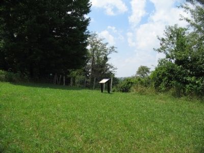
Near Laurel Mountain Road (County Route 15), on the right when traveling east.
Union and Confederate forces clashed along the Beverly-Fairmont Turnpike (the narrow paved road in the foreground) on July 7-11, 1861. Union General Morris was ordered to "amuse" General Garnett at Laurel Hill - to make him believe the main . . . — — Map (db m34439) HM
Near Serpell Avenue east of Side Street, on the right when traveling east.
The "Battle of Laurel Hill,” a series of lively skirmishes between Union & Confederate Troops, took place here on July 7 - 11, 1861. Armies struggled for control of the strategic Beverly & Fairmont Turnpike leading to Confederates . . . — — Map (db m165056) HM
On Philippi Pike (U.S. 250) at Watkins Street (County Route 15), on the right when traveling north on Philippi Pike.
Union troops under Brigadier General T.A. Morris, advanced from Philippi on July 7, 1861 and established a fortified camp near this site. Battle of Belington took place July 7-11. Confederates were two miles to east at Laurel Hill. — — Map (db m34424) HM
On Laurel Mountain Road (County Route 15), on the right when traveling east.
Fortified camp occupied by Confederates under Brig. Gen. Robert S. Garnett. June 16 - July 12, 1861. The scene of sharp skirmishes July 7-11. Garnett retreated early in the morning of July 12 after the Rich Mountain defeat. — — Map (db m34425) HM
On Philippi Pike (U.S. 250) at Watkins Street (County Route 15), on the right when traveling north on Philippi Pike. Reported unreadable.
On the nearby heights, Confederate General Robert Garnett's Army of Northwestern Virginia built fortifications to defend the Beverly-Fairmont Turnpike in June 1861. Many received their baptism of fire here as Garnett's 4,000 Confederates skirmished . . . — — Map (db m249317) HM
Near Laurel Mountain Road (County Route 15), on the right when traveling east.
Confederate artillery was posted here. The cannons were placed behind protective earthworks, still faintly visible today. Their fire swept the Beverly-Fairmont Turnpike below. Model 1841 6-pounder field guns were used at Camp Laurel Hill. Although . . . — — Map (db m253808) HM
Near Laurel Mountain Road (County Route 15), on the right when traveling east.
To honor all who served North and South April 12, 1861 to April 9, 1865 donated by Laurel Mountain Post 410 Veterans of Foreign Wars of the United States Belington, West Virginia March 1, 1999 — — Map (db m34447) HM
On Laurel Mountain Road (County Route 15), on the right when traveling east. Reported unreadable.
"A few dozen of us who had been swapping shots with the enemy's skirmishers, grew tired of the result less battle and by a common impulse - and I think without orders or officers, ran forward into the woods and attacked the Confederate works. We . . . — — Map (db m34456) HM
Near Laurel Mountain Road (County Route 15), on the right when traveling east.
Within this fenced burial ground lie Confederate soldiers who died at Laurel Hill. Their number is unknown. Inscribed headboards once marked the graves. During the Civil War, disease killed more men than bullets. One soldier reported 14 graves in . . . — — Map (db m253809) HM
Near Laurel Mountain Road (County Route 15), on the right when traveling east.
By July 10, 1861, Federal cannons bombarded the interior of Camp Laurel Hill. Confederates may have sought shelter among the boulders nearby. On July 11, General Garnett learned of defeat at Rich Mountain. Fearful of being trapped, Garnett . . . — — Map (db m155082) HM
On Laurel Mountain Road (County Route 15), on the right when traveling north.
Commonwealth of Virginia
Sgt John B Pendleton-Co G 23rd VA Inf
Pvt John H Blake-Co H 23rd VA Inf
Pvt Charles H Goff- Co H 23rd VA Inf
Pvt Robert M Oney-Co B 37th VA Inf
Pvt Fendall C Whitlock-Co G 23rd VA Inf
Pvt James K Davis-Co E . . . — — Map (db m165046) WM
On Laurel Mountain Road (County Route 15), on the right when traveling east.
Battle of Laurel Hill, July 8, 1861, between Confederates and McClellan's army, followed by actions at Rich Mountain and Corrick's Ford, gave Federals control of State and established communication lines to the West. Fine view from peak. — — Map (db m34426) HM
Near Laurel Mountain Road (County Route 15), on the right when traveling east.
Soldiers of the Confederate Army of the Northwest occupied this ground from June 16 to July 11, 1861. Led by General Robert S. Garnett, a West Point instructor of tactics, they dug fortifications on the Mustoe farm to block the Beverly-Fairmont . . . — — Map (db m34437) HM
On Laurel Mountain Road (County Route 15), on the right when traveling north.
Pvt D. Adams
Co D 1st GA
Killed July 8
Pvt J. Davis
Co E 23rd VA
Died July 9
Pvt R. Oney
Co B 37th VA
Killed July 11
Ilt W. Wheeler
Co I 1st GA
Killed July 8
Pvt J. Blake
Co H 23rd VA
Killed July 9
Pvt C. Goff
Co H 23rd . . . — — Map (db m165051) WM
On Morgantown Pike (State Highway 92) at Slate Road, on the right when traveling east on Morgantown Pike.
Meadowville, on the site of an Indian fort built in 1784, is a few miles north. New Jersey colonists settled there before 1800, and tavern, mills, and stores made it a trading center of the Tygarts Valley for a hundred years. — — Map (db m34448) HM
Near Laurel Mountain Road (County Route 15), on the right when traveling east.
Confederate forces retreated from this area after the "Philippi Races" (June 3, 1861), first land battle of the Civil War. At Huttonsville, 26 miles south, Confederate General Robert S. Garnett took command of the Army of the Northwest. His goal was . . . — — Map (db m253810) HM
On Barbour County Highway (U.S. 250) at Arden Road (County Route 6), on the right when traveling north on Barbour County Highway.
Northeast, 3 1/2 miles, is the birthplace of Ida L. Reed, born November 30, 1865. She became famous for her religious writings, chiefly cantatas, poems and hymns, of which she wrote over 2000. Her hymns have been used in the services of eleven . . . — — Map (db m165045) HM
On Junior-Philippi-Grafton Road (U.S. 250), on the right when traveling south.
Barbour County. Formed from Harrison, Lewis, and Randolph in 1843. It is named for a distinguished Virginia jurist, Philip Pendleton Barbour. Scene of opening hostilities on land between the armies of the North and South in 1861.
Randolph . . . — — Map (db m33928) HM
On Buckhannon-Clarksburg Road (West Virginia Route 20) near the county line, on the right when traveling south.
Barbour County. Formed from Harrison, Lewis
and Randolph in 1843. It is
named for Philip Pendleton
Barbour, distinguished Virginia
jurist. The scene of opening
hostilities on land between
the armies of the North and
the South in 1861.
. . . — — Map (db m184509) HM
Near College Hill Road south of Circle Drive West, on the left when traveling south.
Warner's idea came from Sir Issac Newton's, "I Stand on the Shoulders of Giants." He named the statue "Apollo" in appreciation for the space program.
Alderson-Broaddus chose it for the Centennial symbol-1971-because the college's aspirations . . . — — Map (db m211831) HM
On North Main Street (U.S. 250) west of Museum Street, on the right when traveling east.
As Union artillery fired on Philippi, Col. Dumont's infantry pounded across the covered bridge into the 500 people who lived here. In April, when the war was still a lark, local attorneys Thomas Bradford and Albert Gallatin Reger recruited men to . . . — — Map (db m212007) HM
On Court Street north of North Main Street (U.S. 250), on the left when traveling north.
Barbour County Post 44
Dedicated to all
Barbour County Veterans
who served in the Korean War.
July 29, 1989
☆ ☆ ☆
American Legion Post 44
Barbour County
Dedicated to the honored dead of the Korean Conflict . . . — — Map (db m211594) WM
On North Main Street (U.S. 250), on the right when traveling east.
This monument and park are dedicated in sincere appreciation of all Barbour County Vietnam era Veterans who served this great nation - United States of America 1961 - 1973 Dedicated on May 25, 1987 by United States Senator John D. Rockefeller IV . . . — — Map (db m33758) HM
On North Main Street (U.S. 250) at Church Street, on the right when traveling north on North Main Street.
(Front):1917 - 1919 In Memory of Oscar Granville Alexander Clayton Bosworth Brandon Jesse Gordon Cole Quincy C. Dadisman Okey E. Duckworth James Blaine Hovatter Everett Earl Ice David Oren Jones Fred E. Jones John Irvin Kramer Andrew . . . — — Map (db m239225) WM
On Circle Drive East, on the right when traveling north.
(Preface):In the spring of 1861, Union forces rushed into northwestern Virginia to secure the vital Baltimore and Ohio Railroad, protect important turnpikes, and support Unionists against Confederates. The two sides fought numerous . . . — — Map (db m58700) HM
On Mansfield Drive (U.S. 250) at North Main Street, on the right when traveling east on Mansfield Drive. Reported permanently removed.
(preface)
In the spring of 1861, Union forces rushed into northwestern Virginia to secure the vital Baltimore and Ohio Railroad, protect important turnpikes, and support Unionists against Confederates. The two sides fought numerous . . . — — Map (db m211897) HM
On Mansfield Drive (U.S. 250) at North Main Street, on the right when traveling north on Mansfield Drive.
Born in New Hampshire in 1807, he moved to Wheeling and worked as a merchant and as a freight agent for the B&O. He was appointed colonel of the 1st WV (90-day regiment) in
1861 and led the unit at Philippi, where he was seriously wounded. He . . . — — Map (db m211566) HM
On Beverly-Fairmont Pike (U.S. 250), on the right when traveling south.
One mile east is Woodbine Farm, birthplace of W.D. Zinn, noted farmer, writer and lecturer. He contributed much to scientific farming in this and adjoining states. "The Story of Woodbine Farm" is an autobiography of his work. — — Map (db m33776) HM
On Mansfield Drive (Bypass U.S. 250) at North Main Street (U.S. 250), on the right when traveling north on Mansfield Drive.
Churchville cavalry flag made by women of Augusta County, Virginia, and presented to the 14th Virginia Cavalry before they left for Phillipi, captured by Union troops on June 3, 1861. Original flag is at Battle Abbey in Richmond, Virginia. — — Map (db m211895) HM
On Mansfield Drive (Bypass U.S. 250) at North Main Street (U.S. 250), on the right when traveling north on Mansfield Drive.
Flown over the Confederate headquarters at the Virginia house on the main street in Philippi. Headquarters flag was cut down and taken by First Lieutenant Charles A. Griffin of the First (West) Virginia Volunteers from Wheeling. Original flag (6 . . . — — Map (db m211905) HM
On Pike Street at Bosworth Street, on the left when traveling north on Pike Street.
You are standing in the epicenter of the battlefield. Federal artillery shells rained down on this spot, and two Union infantry charges were converging here. Col. Dumont's 1,400 troops thundered across the bridge to your left just as another . . . — — Map (db m212006) HM
On Church Street south of North Walnut Street, on the right when traveling south.
On this site, in a Methodist Church, used as a temporary hospital, on June 3, 1861 J. E. Hanger of Mount Hope, Virginia, underwent a leg amputation by Dr. James D. Robison of the sixteenth Ohio Volunteers. This was the first amputation of the . . . — — Map (db m211849) HM
On Mansfield Drive (Bypass U.S. 250) at North Main Street (U.S. 250), on the left when traveling south on Mansfield Drive.
On June 3, 1861, at 4:30 a.m., Matilda Humphrey, whose house stood on the hill to your left, discharged a pistol at Col. Ebenezer Dumont's Union troops, trying to pull her son, Oliver, off his horse and prevent him from warning the local . . . — — Map (db m211890) HM
On Beverly-Fairmont Pike (U.S. 250), on the right when traveling south. Reported permanently removed.
First land battle between the North and South here, June 3, 1861. Confederates under Col. Porterfield were dislodged by Federal troops from Gen. McClellan's army under Col. Kelley. The old covered bridge here was used by both armies. — — Map (db m211563) HM
On Blue & Gray Expressway (Bypass U.S. 250) west of South Main Street (U.S. 250), on the right when traveling west.
First land battle between the North and South here, June 3, 1861. Confederates under Col. Porterfield were dislodged by Federal troops from Gen. McClellan's army under Col. Kelley. The old covered bridge here was used by both armies. — — Map (db m211625) HM
On Church Street south of North Walnut Street, on the left when traveling south.
Confederate J. E. Hanger's leg was mangled by a cannonball during the Battle of Philippi on June 3, 1861. Hanger survived a surgery that made him the first amputee of the war. After serving time in a Union prison, he returned to his home in . . . — — Map (db m211591) HM
On Buckhannon Road (U.S. 119) 0.3 miles south of Route 57, on the right when traveling south.
Approximately ¼ mile west is the birthplace of Henry Everett Engle, the author and composer of original chorus and music for the Rev. David King's poem, "The West Virginia Hills," in 1885. He was born in 1849, died in 1933. — — Map (db m305960) HM
On North Main Street (U.S. 250) just south of Church Street, on the right when traveling north.
William Draper Anglin •
Denzil Ray Ashby •
Cleophus L. Auvil •
Monzel Barker •
Richard Lavere Bartlett •
Loyd Dextor Beckner •
Dennis Howard Bennett •
Stanley Wilson Bennett •
Hayward R. Bolyard •
Denzil Boyles •
Lynn Jackson . . . — — Map (db m211568) WM
On Graystone Drive, on the right when traveling south.
After the Civil War, Barbour County residents built this one-room school house near Volga, 8 miles SW. As one of the county's first free schools, it was the center of education for hundreds of children, providing instruction for primary through . . . — — Map (db m155092) HM
On Pike Street at North Walnut Street, on the right when traveling east on Pike Street.
Near this spot on the morning of June 3, 1861, James E. Hanger, of Mount Hope, Virginia was injured in the leg by a six pound cannon ball in the first land battle of the Civil War. His leg was amputated by Dr. James D. Robison of the 16th Ohio . . . — — Map (db m308995) HM
On North Main Street (U.S. 250) at Church Street, on the left when traveling south on North Main Street.
As Col. Porterfield's Virginians fled past here, surgeons quickly began to help the injured. The church that stood on the left side of the street served as a hospital. James E. Hanger of the 14th Virginia Cavalry was one of the Confederate . . . — — Map (db m212032) HM
On Mansfield Drive (Bypass U.S. 250) at North Main Street (U.S. 250), on the right when traveling north on Mansfield Drive.
One of the Confederate flags captured at the Battle of Philippi, June 3, 1861. The Palmetto Flag was raised over the Philippi Court House on January 1861, the first Confederate flag to be flown in Virginia. — — Map (db m211894) HM
On North Main Street (U.S. 250) at Court Street, on the right when traveling north on North Main Street.
Originally called Anglin's Ford for William Anglin but later named Booth's Ferry for Daniel Booth. Near by in 1780, Richard, Cottrill, and Charity Talbott settled. Philippi was named for Judge Philip Pendleton Barbour. — — Map (db m33702) HM
On College Hill Drive, on the right when traveling south. Reported permanently removed.
On June 2, 1861, Federal troops advanced on Philippi from the Baltimore & Ohio rail hub at Grafton in two columns of about 1500 men each. The left column, under Col. Benjamin Kelley, took the train six miles east to Thornton, and then marched . . . — — Map (db m211560) HM
On Main Street (U.S. 250), on the right when traveling east. Reported missing.
Col. George A. Porterfield moved his newly recruited Confederates from Grafton on May 28, 1861, after receiving word of a Federal advance on the B&O Railroad. Porterfield's force a Philippi totaled no more than 775 volunteers. Few were fully trained . . . — — Map (db m211925) HM
On North Main Street at Church Street, on the left when traveling south on North Main Street. Reported missing.
As Col Benjamin Kelley’s Federals pursued the Confederates through Philippi, he was shot in the upper right chest by Col. George A. Porterfield’s quartermaster. A surgeon declared it a mortal wound but Kelley recovered. In a show of respect, his men . . . — — Map (db m212033) HM
On Mansfield Drive (U.S. 250) at North Main Street (U.S. 250), on the right when traveling east on Mansfield Drive. Reported permanently removed.
Col. Benjamin F. Kelley
Kelley, a railroad agent in Philadelphia and former resident of Wheeling, was called back to command the First Virginia (Union) Infantry--the first Union regiment raised in the South. He planned and led the attack on . . . — — Map (db m308160) HM
On North Main Street (Bypass U.S. 250) at Museum Street, on the left when traveling east on North Main Street.
In 1888 Graham Hamrick mummified human cadavers using formula unrevealed to this day. Mummies traveled the world; now reside here. — — Map (db m211802) HM
On South Main Street (U.S. 250) at School Street, on the right when traveling south on South Main Street.
Laid by the Masonic Fraternity
August 6 AD 1921 AL 5921
AC Nadenbousch
Grand Master
This is the cornerstone for the Philippi grade, middle and high school that was located on this property and served Barbour County from 1921 until . . . — — Map (db m211626) HM
On College Hill Road south of Circle Drive West, on the left when traveling south.
Named for Dr. Richard E. Shearer, President of Alderson-Broaddus College, 1951-1983.
During the Shearer Administration all the buildings on this quadrangle were erected except one which was completely remodelled. New Main replaced Old Main, . . . — — Map (db m211842) HM
On South Main Street (U.S. 250) at School Street, on the right when traveling south on South Main Street.
As Union soldiers entered the town, Virginia troops came pouring out of Philippi's streets, alleys, and buildings, some getting dressed as they ran.
The Confederates were soon streaming past this location as they fled to Beverly. Northern . . . — — Map (db m212148) HM
On Main Street (U.S. 250), on the right when traveling east.
The Philippi Covered Bridge across Tygart Valley River was built in 1852 by Lemuel Chenoweth of Beverly. Made of wood, with the exception of the iron bolts used to hold the segments together, it is an example of the best in covered bridge . . . — — Map (db m33665) HM
On Mansfield Drive (U.S. 250) at North Main Street, on the right when traveling east on Mansfield Drive.
Constructed in 1852 by Lemuel Chenoweth; masonry by Emanuel J. O'Brien, cost $12,151.24. The covered bridge, erected in 1852, is the only two-lane bridge in the federal highway system. During the Civil War the bridge served both North and South in . . . — — Map (db m33762) HM
On Mansfield Drive (Bypass U.S. 250) at North Main Street (U.S. 250), on the right when traveling north on Mansfield Drive.
The 34-star United States Flag was in the possession of the Federals. West Virginia became the 35th state of the Union on June 20, 1863.
Kiwanis Flag Circle
Made possible by the estate of Dr. Hu C. Myers, a bequest to the Kiwanis Club . . . — — Map (db m211893) HM
On State Highway 38, on the right when traveling west.
Iron ore was discovered here, 1835, by John Johnson. The Old Iron Furnace, built, 1848, was operated for six years by C.W. Bryant and Isaac Marsh. In 1850, a steam engine replaced the water power used to run fan air blast. Charcoal was fuel used. . . . — — Map (db m33929) HM
On Baker Road at Charles Town Road ( Route 9), in the median on Baker Road.
Established as the Newton D. Baker General Hospital, U.S. Army. Named for Newton D. Baker, native of Martinsburg and Secretary of War, World War I. Opened for patients in 1944. It became Veterans Administration Center in 1946. — — Map (db m12784) HM
On Flaggs Crossing Road at Blairton Road on Flaggs Crossing Road.
Named for the property owners this stone bridge built in 1832 across Opequon Creek was major improvement for travellers on Warm Springs Road connecting Alexandria and Bath, Va., site of famous mineral waters. The Berkeley County Court established a . . . — — Map (db m12849) HM
On Winchester Pike (U.S. 11) north of Old Mill Road, on the right when traveling north.
Two miles west is the site of the first house in present West Virginia. It was built by Col. Morgan Morgan who came from Delaware in 1726. It was destroyed and the one now there was built in 1800 by another Morgan. — — Map (db m57717) HM
On Runnymeade Road (County Route 26) at Soldier Drive, on the right when traveling west on Runnymeade Road.
300 yards west is one of the oldest Episcopal churches in West Virginia. Built in 1740 by Morgan Morgan. Five Revolutionary soldiers buried in church yard. Used as a barracks during war between the states. — — Map (db m134064) HM
On Winchester Pike (U.S. 11) just north of Old Mill Road, on the right when traveling north.
Erected by the State of West Virginia. In commemoration of the first settlement within the present boundaries of said State, which was made by Col. Morgan Morgan, a native of Wales, and Catherine Garretson, his wife, in the year 1726 on a tract . . . — — Map (db m1169) HM
On the northbound Welcome Center and Rest Stop (Interstate 81) north of the state line, on the right when traveling north. Reported permanently removed.
After stunning victories at Fredericksburg and Chancellorsville, Virginia, early in May 1863, Confederate Gen. Robert E. Lee carried the war through Maryland, across the Mason and Dixon Line and into Pennsylvania. His infantry marched north through . . . — — Map (db m1975) HM
On Runnymeade Road (County Route 26) 0.2 miles west of Winchester Avenue (U.S. 11), on the left when traveling west.
Due west of this tablet, 650 feet, is the Boyd House in which died, July 17, 1863, Brig.-Gen. James Johnston Pettigrew, of North Carolina, C. S. A. At Gettysburg he commanded and led Heth’s Division in the assault on Cemetery Ridge, July 3; and . . . — — Map (db m305317) HM WM
On Runneymead Road 0.5 miles west of Goldmiller Road, on the right when traveling east.
Originally built 1731-34 as second home of Morgan Morgan-first white settler in West Virginia. Rebuilt with some of original logs in 1976 as a State and County Bicentennial project. It was here during the Revolution that James Morgan, the grandson . . . — — Map (db m12798) HM
On Runnymeade Road (County Route 26) at Soldier Drive, on the right when traveling west on Runnymeade Road.
At Bunker Hill in 1726, Colonel Morgan Morgan founded the first permanent settlement of record in what is now West Virginia. In commemoration of this event, the state of West Virginia has erected a monument in Bunker Hill State Park, and has . . . — — Map (db m134056) HM
On Winchester Pike (U.S. 11) north of Old Mill Road, on the right when traveling north.
Morgan Morgan, a native of Wales, established his home at Bunker Hill before 1732, and was leader in Eastern Panhandle’s early development. His sons gave name to Morgantown, and fought in Indian and Revolutionary Wars. — — Map (db m1176) HM
On Winchester Pike (U.S. 11) south of Hatchery Road (County Route 11/8).
Named for Gen. William Darke, veteran of the Revolution and the Indian wars. He saved the remnants of St. Clair’s army from massacre in 1791 when badly defeated by the Miami Indians. His son, Capt. Joseph Darke, lost his life. — — Map (db m167181) HM
Near Saint Andrews Drive 0.2 miles south of Hammonds Mill Road ( Route 901), on the left when traveling south.
As he advanced south from the Potomac, Union Gen. Robert Patterson sent Gen. James Negley's brigade along a smaller road to the west to guard his right flank. Company I of the 15th Pennsylvania Infantry moved ahead of Negley's main body as . . . — — Map (db m303403) HM
Near Saint Andrews Drive 0.2 miles south of Hammonds Mill Road, on the left when traveling south.
The opposing infantry marched towards each other along the Williamsport Pike, a mile to your front. A skirmish line of McMullen's Rangers led the Union advance, followed by Col. John Starkweather's 1st Wisconsin Infantry. Nearing the Porterfield . . . — — Map (db m303404) HM
On Williamsport Pike (U.S. 11) at Hammonds Mill Road (County Route 901), on the right when traveling south on Williamsport Pike.
On the morning of July 2, 1861, Federal troops under General Robert Patterson crossed the Potomac River from Maryland and marched toward Martinsburg. Confederate Colonel Thomas J. Jackson’s command marched from Camp Stephens, four miles north of . . . — — Map (db m58078) HM
On Williamsport Pike (U.S. 11) 0.2 miles north of Campus Drive ( Route 901), on the right when traveling north. Reported permanently removed.
On the morning of July 2, 1861, Federal troops under General Robert Patterson crossed the Potomac River from Maryland and marched toward Martinsburg. Confederate Colonel Thomas J. Jackson’s command marched from Camp Stephens, four miles north of . . . — — Map (db m180733) HM
On Williamsport Pike (U.S. 11) 0.2 miles north of Beall Road, on the right when traveling north. Reported permanently removed.
On the morning of July 2, 1861, Federal troops under Gen. Robert Patterson crossed the Potomac River from Maryland and marched south toward Martinsburg. Colonel Thomas J. Jackson sent his men north from their camp north of town to block them and . . . — — Map (db m255737) HM
On Hammonds Mill Road (West Virginia Route 901) at St. Andrews Drive (County Route 3/1), on the right when traveling west on Hammonds Mill Road. Reported permanently removed.
Here at Stumpy’s Hollow on the morning of July 2, 1861, Confederate Lieutenant Colonel J.E.B. Stuart captured a Union infantry company almost single-handedly. The Federals—Company I, 15th Pennsylvania Volunteers—were acting as skirmishers in . . . — — Map (db m256875) HM
On Hammonds Mill Road (West Virginia Route 901) at Williamsport Pike (U.S. 11), on the right when traveling west on Hammonds Mill Road.
On the morning of July 2, 1861, Federal troops under General Robert Patterson crossed the Potomac River from Maryland and marched toward Martinsburg. Confederate Colonel Thomas J. Jackson’s command marched from Camp Stephens, four miles north of . . . — — Map (db m277066) HM
On Williamsport Pike (U.S. 11) at Foster Drive, on the right when traveling south on Williamsport Pike.
Early on July 2, 1861, Union forces under Maj. Gen. Robert Patterson crossed the Potomac River from MD to march on Martinsburg. Alerted to the enemy's movements by Stuart's cavalry, Col. Thomas Jackson fought a masterly delaying action that led . . . — — Map (db m206003) HM
On Encampment Road east of Williamsport Pike (U.S. 11), on the left when traveling south.
During the Civil War, the strategically important Valley Turnpike crossed the stream just above the small waterfall here. Two battles were fought nearby. The first occurred on July 2, 1861, half a mile south on the Porterfield Farm. On the . . . — — Map (db m256847) HM
On Saint Andrews Drive (County Highway 3/1) south of Hammonds Mill Road (State Route 901), on the left when traveling south.
The Confederates had four cannons at the Battle of Hoke's, although only one ,vas used in the fighting.
These guns belonged to the 1st Rockbridge Artillery; which had been organized in Lexington, Virginia (in Rockbridge County) in April . . . — — Map (db m303395) HM
Near Saint Andrews Drive 0.2 miles south of Hammonds Mill Road ( Route 901), on the left when traveling south.
Before dawn on July 2, 1861, with the Great Comet of 1861 bright in the sky above, Union Gen. Robert Patterson's troops splashed across the Potomac River at Williamsport, 6 miles northeast of here, watched by a small crowd of civilians—and by . . . — — Map (db m303402) HM
On Williamsport Pike (U.S. 11), on the right when traveling north.
In Memory of General “Stonewall” Jackson This tablet is erected by the Berkeley County Chapter United Daughters of the Confederacy to commemorate an instance of General Jackson’s remarkable bravery at all times in the face of the gravest . . . — — Map (db m41626) HM
Near Saint Andrews Drive 0.2 miles south of Hammonds Mill Road ( Route 901), on the left when traveling south.
Hoke's Run Battlefield Park is a shining example of how preserving battlefields protects more than history. That preservation work also safeguards the natural world around us, protecting the very qualities that make the Shenandoah Valley such a . . . — — Map (db m303401) HM
Near Saint Andrews Drive 0.2 miles south of Hammonds Mill Road, on the left when traveling south.
The Confederate line began to crumble as Union artillery fire took its toll and Federal infantry threatened the southern flanks.
A two-gun section of the 4th U.S. Artillery had come onto the field with the 11th Pennsylvania Infantry. Capt. . . . — — Map (db m303407) HM
On Saint Andrews Drive (County Road 3/1) at Hammonds Mill Road (State Route 901), on the right when traveling south on Saint Andrews Drive.
Here on the morning of July 2, 1861, Confederate Lt. Col. J.E.B. Stuart almost single-handedly captured most of a company of Union infantrymen. The Federals—Co. I., 15th Pennsylvania Volunteers—were acting as skirmishers in advance of a flanking . . . — — Map (db m291614) HM
Near Saint Andrews Drive (County Road 3/1) 0.2 miles south of Hammonds Mill Road (State Route 901), on the left when traveling south.
As the firing grew in intensity around the Porterfield Farm, Union Col. Phaon Jarrett's 11th Pennsylvania arrived on the field. Seeing the 1st Wisconsin already engaged, Jarrett moved his troops west of the pike. His men quickly found themselves . . . — — Map (db m303406) HM
Near Saint Andrews Drive 0.2 miles south of Hammonds Mill Road ( Route 901), on the left when traveling south.
The first pitched Civil War battle in the Shenandoah Valley, the Battle of Hoke's Run, took place here on July 2, 1861, when Confederate troops under Col. Thomas J. Jackson (the future "Stonewall") attempted to block the advance of a Union force . . . — — Map (db m303397) HM
On Williamsport Pike (U.S. 11) east of Ripple Way, on the right when traveling west.
By an act of the Virginia House of Burgesses, 1744, a ferry was established extending from the mouth of the Canagochego Creek in Maryland across the Patowmack to the Evan Watkins Landing, about 250 yards southeast. This landing was also the entrance . . . — — Map (db m131795) HM
On Williamsport Pike (U.S. 11) east of Temple Drive, on the right when traveling west.
West Virginia
(Berkeley County)
"The Mountain State"—western part of the Commonwealth of Virginia until June 20, 1863. Settled by the Germans and Scotch-Irish. It became a line of defense between the English and French during . . . — — Map (db m131797) HM
On Dominion Road 0.1 miles south of Gerrardstown Road, on the left when traveling south.
Built by John Hays, 1743. Became home of Reverend David Gerard, who founded Gerrardstown in 1787. His father was Reverend John Gerard, the first Baptist Minister west of the Blue Ridge Mountains. — — Map (db m12793) HM
On Gerrardstown Road (West Virginia Route 51) 0.1 miles east of Reunion Corner Road, on the left when traveling west.
Established as a town, 1787. Named for John Gerrard, first pastor of Mill Creek Baptist Church, which was organized by early settlers about 1743. The congregation reorganized after Indian hostilities during the French and Indian War. — — Map (db m12791) HM
On Gerrardstown Road (West Virginia Route 51) just north of Dominion Road, on the right when traveling north.
Members of the
Gerrardstown Community who have
proudly served their country in time of conflict
Dedicated in 2004
World War I
Davis Crim • Ashton Faircloth • George Maseur • Frank Miller • Carl Wiest
World War II . . . — — Map (db m148878) WM
4188 entries matched your criteria. The first 100 are listed above. Next 100 ⊳