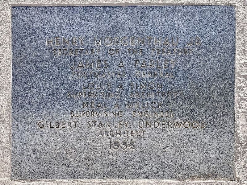
This property has been
placed on the National Register
of Historic Places by the United States Department of the Interior.
Henry Morgenthau Jr,
Secretary of the Treasury.
James A Farley,
Postmaster General.
Louis A Simon, . . . — — Map (db m305185) HM
The Pony Express was an ultra-fast but short-lived mail service that ran between the East and West from 1860 to 1861. The roughly 1,900-mile route began in Missouri and passed through Wyoming and Utah before crossing the Sierra Nevada mountain . . . — — Map (db m76323) HM
Water in Highland Park
The Hunter Highland View, Highland Park,
and Garvanza Tracts were subdivided in 1882,
'85, and '86 respectively. Among the first order
of business was the provision of municipal
water. Toward that end, the . . . — — Map (db m228928) HM
The first television station west of the Mississippi, KTLA-5 has been a part of Los Angeles broadcasting since January 22, 1947. — — Map (db m32469) HM
On this site on January 25, 1949, the first Emmy Awards and Telecast were presented by
the Academy of Television Arts & Sciences. — — Map (db m138345) HM
The Warner Hollywood Theatre was built in 1928 to be
the crown jewel of Warner Bros. West Coast movie houses,
with Sam Warner overseeing construction but dying before
it was completed (his ghost is said to haunt the building).
Entertainer . . . — — Map (db m169952) HM
Sei Fujii was born in Yamaguchi Prefecture, Japan and
arrived in Los Angeles in 1903. An early graduate of
USC Law, he and colleague J. Marion Wright won a US
Supreme Court ruling to build the Japanese Hospital in
1929. Sei Fujii also challenged . . . — — Map (db m230723) HM
Historic site of early Hollywood
motion pictures. Continuously used since 1912. Declared Historic Cultural
Monument No. 198 by the Cultural Heritage Board, Municipal Arts Department, City of Los Angeles. — — Map (db m220076) HM
The Southern Pacific Railroad shanty, also known as a watchman's or signalman's shanty was a 5 foot by 8 foot wooden
structure. This shanty was originally located on the northwest corner of Maclay Avenue and approximately 60 feet
northeast of . . . — — Map (db m200808) HM
The Oscars of Television
If Hollywood could make its mark as the movie capital, then North Hollywood could make television its own.
In 1928, one year after North Hollywood acquired its name, Philo Farnsworth demonstrated the first . . . — — Map (db m156624) HM
Celebrities Sat for His Camera
Back when the fields of the San Fernando Valley helped to feed California and eventually the nation, Fred Hartsook raised champion black and white Holstein dairy cows with names like Bessie, Snowball, . . . — — Map (db m189206) HM
Read All About It!
Back when Lankershim, North Hollywood's predecessor, was literally a growing concern, local newspapers and advertisers enthusiastically ballyhooed the town's virtues.
The Lankershim Laconic went to press in . . . — — Map (db m189208) HM
One day in 1954, 350
students arrived at USC to take a
final exam. Most of them had never
before set foot on campus or even
seen their instructor in person.
Housewives, truck drivers, doctors,
businessmen, actors, schoolteachers and even . . . — — Map (db m229334) HM
From Owl to Eagle
Starting in 1827, African American-owned
newspapers began popping up throughout the
United States, giving a voice to people who had
been largely voiceless. From the late 1800s until
1964, the California
Eagle . . . — — Map (db m229278) HM
In 1914, Joseph and Charlotta Bass purchased the
newspaper, The Owl, and renamed it the California
Eagle. The California Eagle's readership was primarily
African-American. It was a crusader for civil rights
and civil liberties under all of . . . — — Map (db m294434) HM
Blacks on the Record
The largest black newspaper west of
the Mississippi, the Los Angeles Sentinel
was founded by Leon H. Washington
Jr. in 1933. A native of Kansas City,
Washington moved to Los Angeles
in 1930 at the urging of . . . — — Map (db m220020) HM
Ever since USC was founded, its students have sought ways to have their say. The earliest student publication, The College Review, dates back to 1884, only four years after USC was established. A slim monthly magazine, it lasted only the . . . — — Map (db m129532) HM
If USC’s earliest students could travel through time
to today’s university, they would probably find the
changes inside the classrooms even more astounding than the transformation of the campus. Confined to a rigid academic program that included . . . — — Map (db m128480) HM
In 1933, Leon Washington Jr. began publishing the Los Angeles Sentinel for the first time. It grew to
be the largest African-American owned newspaper west
of the Mississippi River. When businesses along
Central Avenue refused to hire residents of . . . — — Map (db m181027) HM
The attached wood is from an original piece of the U.S. Army's Radio Shack from the Tarzana Army Camp,
which was located in its entirety on the Tarzana Ranch from February 1942 through November 1944. The Camp
was the little-known Hqtrs. Coastal . . . — — Map (db m231152) HM
At 10:30 p.m., 29 October 1969, the first ARPANET
message was sent from this UCLA site to the Stanford
Research Institute. Based on packet switching and dynamic
resource allocation, the sharing of information digitally
from this first node . . . — — Map (db m218307) HM
Space Flight Operations Facility
has been designated a
National Historic Landmark.
This building possesses national significance
in commemorating the history of the
United States of America. — — Map (db m231405) HM
For the people called "lookouts," life in a tower offered
challenges beyond being responsible for detecting fire. It
meant coping with confinement, few furnishings, long
hours and dangerous weather conditions.
During a storm, lightning . . . — — Map (db m272352) HM
The site was explored by Juan Rodriguez Cabrillo on Oct. 9, 1542, and named Pointe Vicente Bante Maria by Captain George Vancouver in 1793. Placed in service by the U.S. Lighthouse Service on May 1, 1926, it was renamed Point Vicente by the Pacific . . . — — Map (db m82001) HM
Beginning in 1961, at what was then the Ramo-Wooldridge Corporation, the
dedicated employees of Space Park designed and built more than 100 of the
world's most technically challenging satellites, rocket engines and astronomical observatories. The . . . — — Map (db m141124) HM
Built in 1912 by Pomona Valley Telephone & Telegraph,
the exchange served 112 telephones in San Dimas,
La Verne, Claremont & Chino. The original brick building
was replaced in 1959 by the San Dimas Water Company,
remodeled in 1971 to the Early . . . — — Map (db m168935) HM
The remaining antenna fields and buildings in front of you were established by two cutting-edge worldwide communications companies in 1931. American Telephone and Telegraph (AT&T) radio-telephone station KMI provided two-way voice services between . . . — — Map (db m102641) HM
Point Reyes
Light Station
built 1870
has been placed on the
National Register
of Historic Places
by the United States
Department of the Interior — — Map (db m890) HM
The Radio Corporation of America (RCA) wireless stations on the Point Reyes Peninsula were know as the "Wireless Giant of the Pacific." The station locations and cutting-edge wireless technology developed by the company under the leadership of . . . — — Map (db m102643) HM
Originally constructed for the American Marconi Company, the powerhouse, a 2900 square foot concrete structure, housed the stations transformer, boiler, batteries and workshop. The Marshall Station, in conjunction with the Bolinas Station, made . . . — — Map (db m73755) HM
Bell from Novato Grammar School
Redwood and Grant Ave. Built 1875
The bell was cast by the Gould’s Manufacturing Co., Seneca Falls, N.Y. at a cost of $25.00
Donated by the Manzoni Family — — Map (db m213779) HM
The Postmaster's House, one of the oldest structures in Novato, was built circa 1850 and was originally located on South Novato Blvd west of Yukon Way. The earliest known occupant was Henry Jones, who began Novato's postal service in 1856 and served . . . — — Map (db m102594) HM
Be Safe! Stay on the trail.
Cliffs are unstable and plant life is fragile.
The Point Bonita Lighthouse has guided ships through the hazardous Golden Gate Strait into San Francisco Bay since 1855. This lighthouse has witnessed a remarkable . . . — — Map (db m232190) HM
Built ca. 1922 after an earlier building was destroyed in the 1921 fire that burned most of downtown Tiburon.
This two-story structure originally held a billiards hall and soft drink parlor which is believed to have operated as an illegal saloon . . . — — Map (db m69201) HM
George W. Coulter started a Tent Store here, early in 1850 to supply hundreds of miners working the rich placers of Maxwell, Boneyard and Black Creeks. The settlement was called Banderita, from the flag flying over Coulters store. A postoffice . . . — — Map (db m5955) HM
Storekeeper, W.W. Boone settled in Southern Anderson Valley among families that brought the Scottish and Midwestern patterns of speech in the mid 1890’s. Young men picked hops, sheared sheep, and displayed marvelous whit, cleverness, and . . . — — Map (db m64259) HM
The Point Cabrillo Light Station was built in 1908 by the US Lighthouse Service to protect the "Doghole Schooners" that plied the lumber trade between San Francisco and the Redwood Coast. These steam ships and sailing vessels were known for their . . . — — Map (db m543) HM
On June, 28, 1897 Ukiah became the 118th telephone exchange in California, when the Sunset Telephone Company started providing service. Minnie Smith Scott was the first manager and operator. Female operators were fondly called "Hello Girls", There . . . — — Map (db m96477) HM
Who giving voice to silence
benefitted the world
irradiating a new glorious
light upon Italy
I Figli D'Italia
of
Los Banos
Devoted to their great country
of adoption but unforgetful
of their mother country,
in perpetual . . . — — Map (db m41187) HM
On this site stood the original office of the Bridgeport Chronicle - Union newspaper. In 1880, while still publishing the "Bodie Chronicle", the Folger Brothers, Robert and Alex, started the "Bridgeport Union". The first number of the Bridgeport . . . — — Map (db m37622) HM
Near this location, records show establishment of a post office at Topaz, Mono County, California, February 20, 1885. Discontinued in 1922, it was re-established in June, 1926. Nearby could also be found a school, way-station, blacksmith shop, and . . . — — Map (db m50086) HM
This hall started in 1847, completed in 1848, was named after its builder
Chaplain Walter Colton, U.S.N., 1787-1851
Congregational Minister, historian, author, and editor, who served as alcalde at Monterey from 28 July 1846 to 1 October . . . — — Map (db m63328) HM
This bell was salvaged from the ruins of the 1906 Earthquake in San Francisco and hung at the McMenamin’s Mission Inn.
Robert C. Littlefield acquired it in 1961 and placed it in his garden home.
His widow Patricia donated it to the . . . — — Map (db m63222) HM
Honoring Allen Griffin, 1893-1981, founder and publisher of the Monterey Peninsula Herald for his outstanding contributions to the City of Monterey.
Allen Griffin was the vital force in founding the History and Art Association, the . . . — — Map (db m63509) HM
Dedicated to the memory of
Brigadier General John Weckerling
1896 - 1989
John Weckerling, the founder of the Defense
Language Institute, had a long and distinguished
career of service to the nation, he joined
the Army in 1917 during . . . — — Map (db m235931) HM
“The Oil House”
*****************************
The structure you see before you is a fuel storage house commonly referred to as an ‘oil house’. This oil house was constructed in 1899.
In the 1880’s, before the conversion to . . . — — Map (db m63689) HM
Peter Jensen and
Edwin Pridham's
invention occurred at
1606 F St. in May of 1915.
This statue, unveiled
on May 18, 1985
is the work of Napa
sculptor Franco Vianello — — Map (db m91327) HM
This property has been listed in
the National Register of Historic
Places by the United States
Department of the Interior.
This building was designed by
Napa's leading architect of the
time, Luther M. Turton. The
structure was built for use . . . — — Map (db m153385) HM
Commemorating the First Long Distance Telephone in the World.
Built in 1877, by the Ridge Telephone Co, it connected French Corral with French Lake 58 miles away. It was operated by the Milton Mining Co from this building which was built about . . . — — Map (db m40210) HM
Dedicated August 10, 1986 in honor of
Charles Fayette McGlashan
1847-1931
Truckee’s patriarch, historian, author, editor, attorney, legislator, inventor, entomologist and astronomer.
His last public address was given in 1926 at . . . — — Map (db m81893) HM
Californian, Clamper, Nevada County historian, newspaperman, friend and founding father of the Malakoff State Park in whose memory these benches were placed. — — Map (db m43689) HM
A hero of the Sierra Nevada Mountains!
Probably the first skier of the West. This Viking son of Norway, exemplified the
spirit of a true pioneer. Strong, daring, faithful and courageous he was the answer to California’s motto
“Bring Me . . . — — Map (db m60514) HM
This 1929 building was built as the telephone office for Sidney H. Woodruff's Dana Point development. The unique street facade still retains many of the original feature including the decorative grilles above the front entry porch topped by the . . . — — Map (db m189517) HM
In 1900, the Wardlow Family donated one acre of farm land for a school located on this site.
This bell is from that first school in Fountain Valley. — — Map (db m298785) HM
Hugh Edgar Johnson House 1928 has been listed on the National Register of Historic Places by the United States Department of the Interior.
This Spanish colonial revival house, with Mayan revival-styled features, was constructed for Hugh Edgar . . . — — Map (db m244294) HM
William Pereira's Master Plan envisioned for Irvine an entirely
different approach to living a series of self-contained villages
providing a wide diversity of housing types along with parks,
trails, schools and retail centers. The City's . . . — — Map (db m244148) HM
In 1912 Frank and Hannah Nixon built this modest farmhouse on their small citrus ranch. Here Richard Nixon was born, January 9, 1913, and spent his first nine years. He served his country as Congressman, U.S. Senator, Vice President, and 37th . . . — — Map (db m50342) HM
Historical Landmark
Nearby in this area 1850’s Placer Press paper 1855 to 1858
Above the pioneer livery stable
Temple Saloon & Post-Office 1853 — — Map (db m44088) HM
Established Nov. 26, 1908
This office built 1930
—————
Plaque in Memory of
Pat Jones, Historian
Writer – Colfax Record 1961-1983
Author – The Colfax Connection
Donor – Printing Press . . . — — Map (db m45167) HM
Erected in 1863 – 1864
By John Ziegenbein as a general store
Sold to Herman Lohse 1879; to George Aldrich 1881;
To A.C. Fleming (& Alex Hemphill) in 1888
Bank of Lincoln, Lincoln’s first bank, here 1902 – 1911
U.S. Post . . . — — Map (db m17784) HM
Built in 1915 as Roseville''s first funeral parlor.
Acquired in 1924 by the Brill family to house
the Roseville Register-Tribune our local
newspaper until 1947.
Operated from 1947-1998 as Roseville Printing.
Acquired in 1998 by Donald Smith . . . — — Map (db m135935) HM
Where mail was delivered, horses changed and passengers given rest and a meal. First stage carrying overland mail left Tipton, Missouri on Sept. 15, 1858 and, passing through Temescal arrived in Los Angeles onOct. 7, 1858.
First dedicated by . . . — — Map (db m82155) HM
In the 1870's, Mr. Andrew Kittilson, a native of Norway lived
in Los Angeles with his wife Myra. In 1882, they traveled to
Menifee by horse-drawn wagon to homestead land. They
filed on 160 acres plus an adjacent 160-acre timberculture
claim. . . . — — Map (db m176668) HM
Desert pioneer, Carl Lykken, built the first general store in the village in 1914. For many years it contained the only telephone and the post office. The store was remodeled with the existing overhang and arches when sidewalks were installed in the . . . — — Map (db m52734) HM
Constructed in 1908 this residence is significant both in its exemplary representation of the craftsman style of architecture and its association with Harry W. Hammond, who resided here for seventeen of his forty-nine year history as a principal . . . — — Map (db m304993) HM
Nationally recognized newspaper editor and publisher
Defender of the First Amendment
Driving force and generous benefactor
Leading contributor to the quality of life in the Riverside region:
The Mission Inn
Riverside Art Museum . . . — — Map (db m304267) HM
This Spanish Colonial Revival House was built in 1927 for Alfred A. and Erminie Piddington by builder John V. Philbrick. Henry L. A. Jekel was the architect. The house is located on the south side of the City's original quarry, North Hill, and was a . . . — — Map (db m305115) HM
Henry Jekel designed this Spanish Colonial Revival house for Ernest and Louise Clarke; it was built in 1928. In 1896 Ernest became Editor of the Riverside Daily Press, a position he held for 37 years, and later the Head of the combined . . . — — Map (db m303638) HM
This site is a watering hole that was available for the horses and mules of the
Butterfield Overland Mail Line, known to most as the "Butterfield Stage". The main route for these mail-bearing stagecoaches closely followed the Temecula Creek which . . . — — Map (db m153366) HM
John Butterfield's Overland Line had a federal contract to carry mail from Tipton, Missouri to San Francisco. Butterfield Overland stagecoaches carried passengers and mail roughly following the Southern Emigrant Trail, making the trip each way . . . — — Map (db m283197) HM
Gold Rush and Railroad town Folsom became the Western Terminus of the Central Overland Pony Express on July 1, 1860. The express mail had been run by pony to and from Sacramento. Beginning on July 1, 1860, the
Sacramento Valley Railroad carried it . . . — — Map (db m5090) HM
In Memory of J. Clifton Toney
Publisher of the Folsom Telegraph
1962 – 1976
His vision resulted in the
Development of the Sutter Street Mall — — Map (db m14378) HM
To the memory of the riders of the
Pony Express, 1860-1861
First relay station out of Sutter's Fort.
Dedicated April 19, 1936
by the Native Sons and Daughters
of the Golden West. — — Map (db m61348) HM
The famed Pony Express was an overland mail service delivering messages, newspapers, mail, and small packages from St. Joseph, Missouri, across the Great Plains, over the Rocky Mountains and the Sierra Nevada to Sacramento by horseback, using a . . . — — Map (db m214501) HM
This commemorative bell celebrates a combined century of service by the California Federation of Women’s Clubs and California State Automobile Association including the establishment of bell markers along the historical El Camino Real. — — Map (db m14819) HM
Anthony J. "Tony" Monti sold newspapers on this corner for 35 years. He lost a leg in an accident early in life and sold newspapers here day and night to support his mother and sister. All of the Governors of the State of California from 1915 to . . . — — Map (db m27236) HM
Departing at 2:45 A.M. from the Alta Telegraph Co. in Sacramento, Pony Rider Sam (Bill) Hamilton carried the first mail eastward of the Central Overland Pony Express on April 4, 1860. Here quickly changing ponies he sped on to the next stop at . . . — — Map (db m261278) HM
In 1911, the complete telephone man was mobile, mechanized and well-equipped. With his tools around his waist, he carried phones on his back, on his chest and in his bicycle sack. — — Map (db m266340) HM
An incredible maze of messy telephone wire crowds downtown in 1911. A typical problem all over the country as telephone business proliferated, the lines were both unsightly and dangerous. Soon, engineers began replacing them with underground cable. — — Map (db m266309) HM
A parade float in Sacramento, California Circa 1915
This picture was take just a few feet away from this location. Check out the "Ghost" to the left of the float on the side walk. — — Map (db m266314) HM
Directory operators, each with a series of telephone directories in front of them bound in metal boxes and with their own scaled-down board, assisted customers in 1958. Operators worked a very large switchboard in the background. — — Map (db m266345) HM
A safety-man's nightmare as this rugged plant crew of the 1890's celebrated the completion of a pole line by having their pictured snapped, atop the biggest pole. — — Map (db m266289) HM
A variety of phones provided by AT&T over the years.
[Captions for the six phones in the photograph:]
"Coffin" Wall Telephone (1878)
Dial Candlestick Phone (1919)
"300" Series Desk Phone (1937)
Princess Phone (1959)
Big Button Design . . . — — Map (db m266284) HM
5362 entries matched your criteria. Entries 301 through 400 are listed above. ⊲ Previous 100 — Next 100 ⊳