On Franklin Avenue at Ramapo Valley Road (U.S. 202), on the right when traveling west on Franklin Avenue.
Located on Ramapo Valley Road key military highway for troops and supply units during the Revolutionary War this building served as General George Washington's headquarters on July 14, 1777 and as the Bergen County Court House in 1778 – 1779. — — Map (db m12335) HM
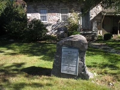
On Dogwood Drive at Ramapo Valley Road (U.S. 202), on the right when traveling west on Dogwood Drive.
Built about 1789 by Jacobus S. Demarest, the frame wing was added later. Demarest served in the Revolutionary War. Over the years his farm grew to 180 acres. In 1835 his son, Daniel J. Demarest, inherited the farmhouse. In 1863 it passed to his . . . — — Map (db m12401) HM
On Ramapo Valley Road (New Jersey Route 202) at Veteran Drive, on the right when traveling south on Ramapo Valley Road.
The Lenni Lenape Indians deeded the first land to Dutch colonist Arent Schuyler in 1695. It was then called Yaupough. The “Valley Road” was an important supply artery of the American Revolution. On July 14, 1777, General George . . . — — Map (db m12896) HM
On Kinderkamack Road (County Route 503) at Soldier Hill Road, on the left when traveling north on Kinderkamack Road.
The Continental Army advanced to Englewood on August 23, 1780, with some units foraging as far south as Jersey City. The main body of the army moved west of the Hackensack River on September 4th, camping in two lines west of Kinderkamack Road, one . . . — — Map (db m7552) HM
On Spring Valley Road at Viola Way, on the left when traveling south on Spring Valley Road.
The historic cemetery directly in the rear of the Behnke farm contains the graves of descendants of early settlers in this area including a least two local farmer-militiamen of the American Revolution, Jacobus Brouwer and Henry Banta, as well as . . . — — Map (db m8345) HM
On North Farview Avenue at Sweetbriar Avenue, on the right when traveling south on North Farview Avenue.
The Indian name given this community by its Dutch settlers means “fields of wild turkeys”. A fertile farming area, Paramus was familiar ground to both the British and American armies during the Revolution. Formerly a part of Midland . . . — — Map (db m16968) HM
On Red Mill Road at Saddle River Road, on the right when traveling west on Red Mill Road.
Site of grist mill built 1745; scene of many raids and encounters during the Revolution. Aaron Burr was entertained here Christmas Eve commemorating his victory over British Raiders in 1776. Washington and his men often passed here. Lafayette . . . — — Map (db m8370) HM
On Paramus Road at Century Road, on the right when traveling north on Paramus Road.
Pre-Revolutionary homestead of David Terhune (1713-1792), weaver and patriot official who served as Freeholder from New Barbadoes Township 1779 to 1785; and of his son, John D. Terhune, a Freeholder in 1787. Farm raided by British four times during . . . — — Map (db m18995) HM
On Forest Avenue, on the left when traveling north.
The Continental Army is reported to have utilized the old spring at the base of these slopes during the September encampment west of the Hackensack River. Reports indicate that General Washington visited here and drank water from the spring. — — Map (db m8413) HM
On Forest Avenue, on the left when traveling north.
Howland Avenue divided the farms of miller Cornelius Van Saun to the south and Christian Dederer to the north. Hendrick Banta lived west of Mill Creek. The Continental Army moved into Bergen County in August 1780 to forage for food and to await the . . . — — Map (db m8412) HM
On Homestead Pl, on the left when traveling north.
Built about 1775 by John Paulison who owned 150 acres in what was then known as “Old Hackensack”. The farm was raided by the British during the Revolutionary War. In 1826 the house was inherited by his son Paul Paulison. Purchased in 1844 by David . . . — — Map (db m7154) HM
On E. Ridgewood Avenue at Van Neste Square, on the right when traveling south on E. Ridgewood Avenue.
Brigadier General Abraham Godwin Soldier, Statesman, artist, poet, engraver, musician and gracious host. Born July 16, 1763.
His career began at the age of thirteen when his brother, David, aged eleven, he left home at Totowa to join Captain . . . — — Map (db m22133) HM
On E Glen Avenue, on the right when traveling east.
Near this House of God encamped General Washington and his army in 1778 In grateful tribute to the memory of the patriots who sleep in the adjacent church yard and to the men and women of this community who assisted so valiantly in the establishment . . . — — Map (db m25022) HM
On E Glen Avenue, on the right when traveling east.
Organized in 1725 by pioneer Dutch settlers, the congregation of this church has worshipped here over 240 years. First church, built 1735 on this land given by Peter Fauconier, a French Huguenot, was a headquarters of Gen. George Washington in . . . — — Map (db m24983) HM
On Tenney Avenue at Kindermkerack, on the right when traveling west on Tenney Avenue.
Sections were once known as Kindermack, Steenrapie, Old Bridge and New Bridge. George Washington, in 1776, retreated across New Bridge and the hill above was fortified by the British in 1778. In 1780 the Americans encamped in town with the HQ of . . . — — Map (db m36452) HM
This is a reproduction of an 18th century military camp kitchen. Camp kitchens like these were generally constructed when an 18th century army was encamped for a few days or weeks. Each kitchen could accommodate 11 to 12 fireplaces with chimneys . . . — — Map (db m90862) HM
On Old New Bridge Avenue, on the left when traveling east.
A Revolutionary War Battleground at the Bridge that Saved a Nation These are the times that try men’s souls . . . 3 Historic Homes • Distinctive Jersey Dutch Architecture & Artifacts — — Map (db m51305) HM
On Main Street at Hackensack Avenue (County Route 503), on the right when traveling west on Main Street.
Pre-History - The Tappans, affiliated with the Minisinks, occupied the northern valley of the Hackensack River and its major tributaries, extending downstream to French Creek at New Bridge. The tidal lowlands to the south were occupied by the . . . — — Map (db m74100) HM
On Main Street at Hackensack Avenue (County Route 503), on the right when traveling west on Main Street.
Native American Settlement • Colonial Settlement • Battleground in The American Revolution • 20th Century Recreation • Historic Site Historic New Bridge Landing Park remarkably preserves a scenic fragment of the Jersey Dutch . . . — — Map (db m186399) HM
1) Steuben House. Jan and Annetje (Ackerman) Zabriskie prospered as miller and merchant at this site. They built a five-room stone cottage in 1752 and enlarged the house to the present size in 1767 by adding a second story along the rear and . . . — — Map (db m237183) HM
The first “new bridge” erected in 1745. It was a strategic crossing during the Revolution used by Washington’s army during the 1776 retreat. In 1888/89, the wooden span was replaced by this iron swing-bridge, now the oldest such bridge . . . — — Map (db m68879) HM
Near Main Street, on the left when traveling east.
Washington’s rear guard under Greene held the bridge in the Retreat of 1776. Burr attacked British here in 1777 and Lee’s expedition against Paulus Hook started from here 1779. Bridge crossed often by both armies during the Revolution. — — Map (db m90858) HM
Site of the Zabriskie Grist Mill and wharf near the head of navigation on the Hackensack River. Farm produce and iron from the Ramapo Mts. were shipped from here to market. The mill, once powered by the tides, burned in 1852 after a century of . . . — — Map (db m7468) HM
Near Main Street, on the left when traveling east.
A Tory’s property, seized during the Revolution, was presented by New Jersey to Baron von Steuben, Gen. Washington’s drillmaster. — — Map (db m96856) HM
This Dutch Style sandstone house had stood in New Milford since the Revolution. Faced with demolition it was saved for our country’s heritage by moving it to this site on September 27, 1977. This preservation was accomplished through the combined . . . — — Map (db m7465) HM
Erected 1752 and presented to Maj. Gen. Von Steuben by the State of New Jersey 1783 in recognition of New Jersey’s share of the debt which the nation owed the General. — — Map (db m51303) HM
British close the Port of Boston in response to Boston Tea Party, Mar 25. 1st Continental Congress is called in response to the Intolerable Acts, Oct 20, 1774. Jan Zabriskie & Annetje Ackerman enlarge the 1752 house in 1767. He dies; . . . — — Map (db m190753) HM
On Red Oak Drive at Rivervale Road, on the right when traveling east on Red Oak Drive.
Late one night in 1778, the woods you are standing in suddenly echoed with the sounds of battle. A surprise attack by British soldiers nearly destroyed an American regiment, Baylor’s 3rd Continental Light Dragoons. Today, this park tells the story . . . — — Map (db m8455) HM
On Red Oak Drive, on the right when traveling east.
The evening of September 27, 1778, found Baylor’s Dragoons settling for the night near this site. The neighborhood’s name, Overkill, came from the small bridge “Over de kill”, a kill being a creek or river to the Jersey Dutch settlers. It . . . — — Map (db m8454) HM
On Red Oak Drive at Rivervale Road, on the right when traveling east on Red Oak Drive.
“This millstone is the only visible marker of the Baylor Massacre in existence today. On September 28, 1778, a detail of Baylor’s Continental Dragoons camping at Haring’s Tannery in River Vale was betrayed into the hands of the British by a Tory . . . — — Map (db m7876) HM
On Red Oak Drive at Rivervale Road, on the right when traveling east on Red Oak Drive.
In memory of American soldiers killed during the Revolutionary War in the “Baylor Massacre” on September 28, 1778. Lt. Col. George Baylor’s 3rd Regiment of Continental Dragoons took quarters for the night on several nearby farms. Tories betrayed . . . — — Map (db m7874) HM
On Red Oak Drive at Rivervale Road, on the right when traveling east on Red Oak Drive.
Six soldiers of those killed in the Baylor Massacre were buried here in three abandoned tan vats. The vats were part of a small tan yard which existed here before the Revolution.
The gravesite was discovered in 1967 and the soldiers were . . . — — Map (db m7875) HM
On Red Oak Drive at Rivervale Road, on the right when traveling east on Red Oak Drive.
The American army may have had trouble supplying its soldiers and keeping them fit for fighting, but in one way the Americans were superior: their propaganda writers were experts at whipping up anti-British feelings. An incident like the Baylor . . . — — Map (db m8474) HM
Here as they slept at dawn on Sept. 28, 1778 Col. Geo. Baylor and 116 Virginia Dragoons were attacked by the British under General "No Flint" Grey. Major Clough, Surgeon George Evans, with fifty other Colonial troopers were killed. — — Map (db m55831) HM
On Red Oak Drive at Rivervale Road, on the right when traveling east on Red Oak Drive.
In September 1778, British commanders sent huge foraging parties up both sides of the Hudson River, stripping the local farms of their autumn harvest and livestock. Washington’s forces in the area were seriously outnumbered, but he sent small . . . — — Map (db m8456) HM
On Red Oak Drive at Rivervale Road, on the right when traveling east on Red Oak Drive.
The Aftermath Imagine the scene in the early morning daylight of the morning of September 28, 1778 at Overkill:
. American soldiers were dead, wounded and missing. Some escaped, others were British captives. . Major Charles Clough lay dying. . . . — — Map (db m8472) HM
On Red Oak Drive at Rivervale Road, on the right when traveling east on Red Oak Drive.
Washington’s army marched mostly on its feet. But the General also formed four “regiments of horse,” the Continental Light Dragoons. Although costly to maintain, the Light Dragoons performed a valuable service. They provided a way for . . . — — Map (db m8471) HM
On Piermont Road (County Route 501), on the right when traveling south.
Erected on a 200 acre farm by Abraham A. Haring, a captain in the Bergen County Militia. During the Revolutionary War, Haring was captured by the British and imprisoned in New York City where he died. In 1805 his grandson, Abraham D. Haring, sold . . . — — Map (db m8685) HM
On Piermont Road (County Route 501), on the right when traveling south.
An early 19th century example of Dutch Colonial architecture erected by John A. Haring. Small wing added c. 1808; rear stone section built by a Haring about the time of the Revolutionary War. Inherited in 1854 by son Nicholas J. Haring, the . . . — — Map (db m8686) HM
On Rockleigh Road at Piermont Road (County Route 501), on the right when traveling north on Rockleigh Road.
A colonial road that led from Closter to Snedens Landing – the western terminus of Dobbs Ferry on the Hudson. Part of this road was built by New York in 1748 when that Province governed this area. Used by troops during the Revolutionary War. . . . — — Map (db m8632) HM
On Main Street (Old New Bridge Road), on the left when traveling west.
Site of:Hackensack Indian Village, and The Real George Washington Bridge This 10½ acre park named after Teaneck Mayor and open space advocate Clarence “Jim” Brett is one of the most historically significant site in Teaneck, indeed . . . — — Map (db m40228) HM
On Teaneck Road at Cedar Lane, on the right when traveling south on Teaneck Road.
Troops of the American army camped in this vicinity from August 22 to September 3, 1780, in order to forage for food and horses. The encampment extended to the north and east of Teaneck Road for about two miles. Situated near British-held New York . . . — — Map (db m7221) HM
On Westervelt Ave east of Tenafly Road, on the right when traveling east.
This house is a fine example of Dutch Colonial architecture. The south wing of the house was built by Roelof Westervelt in 1745. The land had been purchased by his grandfather, in 1695, from the Lord Proprietores of East Jersey. The central section . . . — — Map (db m7210) HM
On Main Ave at Paterson Ave, on the right when traveling west on Main Ave.
Gen. George Washington’s Army pursued by the British crossed over here November 21, 1776 destroying the wooden bridge behind them.
Placed by the combined civic organizations of Wallington Nov. 21, 1976 — — Map (db m7043) HM
“I came here, where freedom is being defended, to serve it and to live or die for it.” Mortally wounded at age 32 in the Battle of Savannah, Georgia October 11, 1779 — — Map (db m33587) HM
On First Avenue at Mill Street, on the right when traveling north on First Avenue.
Near here on Musquapsink Brook stood the earliest grist mill in Pascack built 1734 by Rev. Johannes Bernardus Van Dierren, a Lutheran Pastor. In 1765 it was purchased by Isaac Bogert and owned by his descendants until destroyed by fire in 1910. . . . — — Map (db m43779) HM
On Sicomac Avenue, on the right when traveling west.
Erected about 1812 by John C. Stagg on site of earlier building owned by his father, Cornelius Stagg, a veteran of the Revolutionary War. The basement was operated as a grocery store for many years by John C. Stagg. His son, Albert, sold to Richard . . . — — Map (db m12404) HM
On Franklin Avenue at Maple Avenue, on the right when traveling west on Franklin Avenue.
Built in 1824 by Albert Van Voorhees, this Federal home replaced his earlier house. The land, owned by father William since 1720, was called “Wikehoff”. Albert, a veteran of the Revolution and a Justice, deeded the new home to grandson Albert J. . . . — — Map (db m12407) HM
On Broad Street at Bank Road, on the right when traveling north on Broad Street.
Near this site, one of our country’s first ferries was operated from circa 1695 to late 19th century. During Revolutionary times, it was used by Washington and his troops. This area was called “Dunks Ferry” before Beverly, N.J. was . . . — — Map (db m35872) HM
On Crosswicks Street (County Route 528) at Hopkinson Street, on the left when traveling west on Crosswicks Street.
Following the Continental Army's retreat across the Delaware River in December 1776, 2,000 Hessian and Scots troops commanded by Colonel Kurt vonDonop occupied this towne.
A small band of Americans under Colonel Samuel Griffin lured these . . . — — Map (db m33635) HM
Waters of Crosswicks Creek and the Delaware River join below. 22 vessels at Bordentown and 4 at White Hill were among the 44 that were destroyed in a British raid on May 8, 1778. All were trapped in the Upper Delaware when the British took . . . — — Map (db m5336) HM
On Farnsworth Avenue (County Route 545) at Park Street (County Route 662), on the right when traveling north on Farnsworth Avenue.
This tablet marks the home of a famous Revolutionary Patriot, a signer of the Declaration of Independence and originator of the Great Seal of New Jersey, member of Congress, a statesman, scientist, artist, musician and great satirist. — — Map (db m33453) HM
On County Road 662 at Farnsworth Avenue, on the left when traveling east on County Road 662.
Though never larger than a small village, a remarkable cross section of notable and influential people lived in Bordentown in the eighteenth and nineteenth centuries.
Leaders of the American Revolution who lived on Farnsworth Avenue included . . . — — Map (db m160154) HM
On West Park Avenue at Farnsworth Avenue on West Park Avenue.
Patience Lovell Wright was America’s first professional sculptor and a self-appointed Revolutionary War spy. A native of Bordentown, she lived in this house after her marriage to Joseph Wright in 1748. She learned from her sister, Rachel, how to . . . — — Map (db m152759) HM WM
On Farnsworth Avenue (New Jersey Route 545) at West Church Street, on the left when traveling north on Farnsworth Avenue.
Thomas Paine, Pamphleteer for American Independence, bought this house in 1783, and lived in it periodically until his death in 1809. — — Map (db m33451) HM
On Prince Street at Courtland Street, in the median on Prince Street.
Thomas Paine (1739 - 1809)
Father of the American Revolution
(Northeast face of Monument Base):
Paine's words and deeds put the concepts of independence, equality, democracy, abolution of slavery, representative government and a . . . — — Map (db m5176) HM
On W Broad Street west of Wood Street, on the right when traveling west.
In July 1695, a group of local residents, including John Tatham, Edward Hunloke, and Nathaniel Westland, purchased a lot on this site on the west side of Wood Street "for the Conveniency of a burying place for themselves and also for all other . . . — — Map (db m172333) HM
On Columbus Road (County Route 543) 0.3 miles east of Petticoat Bridge Road, on the right when traveling east.
On a tree south of this spot British Corporal John Fisher, 28th. Regiment
who had deserted the British to join the Rebels
was caught, tried and convicted. He was hung
at 10 AM June 22, 1778 — — Map (db m34200) HM
On Petticoat Bridge Road at Columbus Road (County Route 656), on the left when traveling north on Petticoat Bridge Road.
The Keeler Oak is a White Oak
(Genus: Quercus, Species: alba)
88' tall with a drip line of 120'.
This 300 year old tree was witness
to the Colonial troops and Hessian
soldiers as they marched through
Black Horse down to Petticoat . . . — — Map (db m33353) HM
On Columbus Road at Petticoat Bridge Road on Columbus Road.
The Keeler Oak is a White Oak (Genus: Quercus, Species: alba) 88' tall with a drip line of 120'. This 300 year old tree was witness to the Colonial troops and Hessian soldiers as they marched through Black Horse down to Petticoat Bridge where a . . . — — Map (db m244457) HM WM
On June 23, 1778, General Dickinson’s Jersey Troops destroyed bridge, fighting a skirmish to delay the British march to New York. — — Map (db m93719) WM
Quakers settled Crosswicks in 1677 and purchased this land toward the end of that century. Friends have worshiped on this site continuously since that time. The smaller building was erected in the mid 1780's for use as a Quaker school and is now . . . — — Map (db m36084) HM
On 4th Street (County Road 622) at Washington Street, on the right when traveling west on 4th Street.
Fieldsboro, incorporated in 1850, is the smallest municipality in Burlington County. Early land records identify the area as White Hill. One of its early settlers was Robert Field, who owned a wharf on the Delaware River, several businesses and a . . . — — Map (db m160138) HM
On 4th Street (County Road 662) at White Hill Mansion Road, on the right when traveling south on 4th Street.
White Hill Mansion stands at the end of a long avenue on a bluff overlooking the Delaware River. The earliest known sections of the house were built in the eighteenth century and there were many subsequent additions and changes over the following . . . — — Map (db m194816) HM
On Chairville Road at Marlton Pike (Route 70), on the right when traveling north on Chairville Road.
Adonijah Peacock, a casualty of the gunpowder explosion of 1777 lies here among several generations of his family descendants. 1847-1997 — — Map (db m102409) HM
Oldest center portion c. 1738, with later additions 1760’s, the Smith Mansion and 160 acre farm, which hosted Lafayette during the American Revolution, was also raided by Hessian troops. Presented 19 October 2000 The Rancocas Valley Chapter . . . — — Map (db m35879) HM
On Pine Street, on the right when traveling south.
Here on December 23, 1776 was fought the Battle of Ironworks Hill. This diversionary tactic aided Washington to capture Trenton. — — Map (db m35868) HM
On Pine Street, on the right when traveling south.
A decisive skirmish in the Revolutionary War. Colonel Samuel Griffin’s troops were entrenched at this site. They decoyed Colonel (Count) Kurt von Donop’s Hessian soldiers away from Bordentown thus reducing the enemy forces defending Trenton and . . . — — Map (db m237155) HM
On Petticoat Bridge Road, on the right when traveling north.
On orders from General Washington to pull Hessian troops southward from positions of support near Trenton, 600 Americans, stationed at Mount Holly under Colonel Samuel Griffin, attacked a Hessian outpost here on December 21. When the 3,000 Hessians . . . — — Map (db m35866) HM
On Jacksonville Jobstown Road, on the right when traveling east.
The brick structure standing near this point, is Copany Meeting House, built in 1775, following a skirmish between American units under Colonel Samuel Griffin and Hessian troops commanded by Colonel Kurt von Donop at nearby Petticoat Bridge on . . . — — Map (db m35867) HM
Part of General Clinton's British Army under the Hessian General Knyphausen passed by here on the way to capture Mount Holly on June 20, 1778.
At nearby Hainesport a skirmish developed when Patriots destroyed the bridge over the Rancocas Creek. . . . — — Map (db m117292) HM
On Moorestown - Mount Laurel Road at Hainesport Road, on the left when traveling east on Moorestown - Mount Laurel Road.
Oldest Friends Meeting House in Burlington County – Used as barracks for General Clinton’s troops in June 1778 Built 1760 Addition 1798 — — Map (db m35883) HM
On Beverly Rancocas Road at John F. Kennedy Way on Beverly Rancocas Road.
William Franklin, son of Benjamin Franklin, and last royal governor of New Jersey, had his country home here and owned the property from 1770-1785. As a boy he participated in the lightning experiment with his father. Appointed governor in 1763 by . . . — — Map (db m94766) HM
On Clementon Road (County Road 534) just west of Franklin, on the right when traveling west.
In remembrance of all buried here
including:
Lenape Indians — Hessian Soldiers
Arthur R. Eldred
First Eagle Scout of the Boy Scouts of America
Aug. 21, 1912
Capt. Carlton R. Rouh U.S.M.C.
Awarded Congressional . . . — — Map (db m146761) HM WM
Built about 1725, this became the home of Richard and Charity Chew Powell who had 21 children including 17 sons who served in the American Revolution. The Powells and several sons are buried nearby. — — Map (db m94974) HM
On South 5th Street just north of Dr. Martin Luther King Boulevard, on the right when traveling south.
A
tribute to
the father of our country
by the Patriotic Order of the
Sons of America
the
County of Camden
the
City of Camden
the
Charles Cornell Construction Corp.
and the
Union of Operating Engineers Local #825 . . . — — Map (db m245148) WM
The Cherry Hill area was at times occupied by both forces in the Revolutionary War in 1777. Continental soldiers joined with local farmers in destroying strategic bridges across the Newton and Timer Creeks to delay the Hessians who were marching . . . — — Map (db m94767) HM WM
On Brace Road (County Route 154), on the left when traveling south.
Here, Old Salem Road, laid out 1681 – 1686, crossed the north branch of Cooper River. The British Army used this road from Haddonfield, June 19, 1778, their right wing branching to Evesham and the left to Moorestown, enroute to Monmouth Court . . . — — Map (db m29226) HM
On Station Avenue at Melvin Avenue on Station Avenue.
1626 On this high bank along the Timber Creek was the Indian Village of Armewamex
1730 John Ashbrook in his will reserved “…one whole acre where the burying place now is for the use of the neighborhood.” Making this the . . . — — Map (db m94917) HM WM
The Gabreil Daveis Tavern was built in 1756 as part of a 178 acre plantation. This was the first recorded tavern along the “Irish Road”, the great road leading from Gloucester Township to Great Egg Harbor. Guests could find lodging and meal for a . . . — — Map (db m220202) HM WM
The unusual topography in the McLaughlin-Norcross Dell area of the Camden County Park dates to the Colonial period. The steep slopes were related to King’s Run, a navigable waterway that provided the area’s first means of transportation in the 17th . . . — — Map (db m79636) WM
During the Revolutionary War the Hessian Army was encamped on these grounds before and after the battle of Red Bank, fought October 22, 1777, near Fort Mercer on the Delaware River, where it met defeat.
The officers occupied the houses on the west . . . — — Map (db m79614) WM
On Kings Highway (New Jersey Route 41) at Kings Lane, on the right when traveling south on Kings Highway.
Oct. 21, 1777, Col. von Donop camped here before the Battle of Red Bank. Gen. Wayne and Col. Ellis foraged nearby in Feb., 1778, but left on the approach of Maj. Simcoe. June, 1778, the British under Clinton and Knyphausen camped here en route to . . . — — Map (db m189466) HM
On Kings Highway (New Jersey Route 41), on the right when traveling south.
Within this building then a tavern-house, the Council of Safety for New Jersey was organized March 18th 1777. Herein also, in September of the same year the Legislature unanimously resolved that thereafter the word “state” should be . . . — — Map (db m29230) HM
On Kings Highway (New Jersey Route 41), on the right when traveling south.
In late 1776, the British Army invaded northern New Jersey. The New Jersey Legislature fled south to Haddonfield. In May 1777, Hugh Creighton, keeper of the Indian King Tavern, purchased the dwelling in which the New Jersey Assembly had rented a . . . — — Map (db m74234) HM
On Kings Highway (New Jersey Route 41) at Mechanic Street, on the right when traveling south on Kings Highway.
With four cannon and 1600 Hessian troops, Count von Donop camped 300 yards east of here en route to Fort Mercer at Red Bank. A prisoner that night, Jonas Cattell, 18 years old, was released when the enemy moved out before daylight. He ran to warn . . . — — Map (db m237149) HM
On Jackson Street at Lafayette Street (County Route 633), on the right when traveling north on Jackson Street.
In memory of Lt. Richard Wickes who died June 29, 1776 in an engagement near Cape May • • • Lt. Wickes was one of the first naval casualties of the American Revolution • • • Dedicated June 26, 1976 by Harry Snyder . . . — — Map (db m46259) HM