On Northwest Main Street (U.S. 71) north of Oak Street, on the right when traveling north.
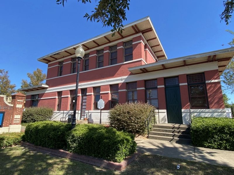
The Texas and Pacific Railway established a
station on the main line at Bunkie in 1882. The
current depot, built in 1911 and listed on the
National Register of Historic Places, is the only
existing reminder of the importance of the
railway to . . . — — Map (db m208821) HM
On Business U.S. 171 east of South Pine Street (Louisiana Highway 27), on the right when traveling east.
Center Panel
In 1912 when residents decided to divide Imperial Calcasieu Parish
into several smaller parishes, Beauregard Parish was born. The
people of Beauregard were optimistic about their future, and as . . . — — Map (db m229089) HM
On Main Street (U.S. 80) north of South 2nd Street, on the right when traveling south.
This Is The Location Of Ma Canfield's Cafe Where Bonnie Parker And Clyde Barrow Stopped At 9am On May 23, 1934, Picked Up Sandwiches And Drove Off To Their Deaths 7 Miles Away. — — Map (db m181170) HM
On Dixie Shreveport Road (State Highway 3049) south of Cornhusker Road, on the left when traveling north.
Typical of the large river plantations of the mid-nineteenth century, land was owned on both the Caddo and Bossier sides of the Red River. Beginning in 1849 Woodlawn was successively owned by several large land owners of the region, the A.D. Palmer . . . — — Map (db m196110) HM
On Dixie Shreveport Road (Louisiana Route 3049) north of Louisiana Route 169, on the right when traveling north.
Killarney was built by James Stuart Douglas in 1920 and designed by Edward F. Neild, a prominent Shreveport architect in the firm C. E. Olschner Architect Assoc. This is one of the first homes designed by Mr. Neild. Mr. Douglas was a planter, civic . . . — — Map (db m175663) HM
On Dixie Shreveport Road (Louisiana Route 3049) at Cornhusker Road, on the right when traveling north on Dixie Shreveport Road.
The W.H. North Plantation dates back to 1886. The original home was moved with mules and wagons from the bank of Red River in 1903 to the present site on Cottonwood Bayou. After being destroyed by fire in 1923, the home was rebuilt on the original . . . — — Map (db m175850) HM
On U.S. 71, 0.1 miles north of Camellia Street, on the right when traveling north.
The house was built around 1878 and occupied by the William Adams family. James Patrick Fuller and his wife Gertie McKinney Fuller purchased the house in 1919. Their family included daughters Pattie Mae and Audrie, who was born in the house in 1920. . . . — — Map (db m244247) HM
On East Magnolia Lane east of U.S. 71, on the right when traveling east.
This building was erected in 1923 by W.C. Reynolds, an early Postmaster in Ida. It was the location for the Ida Post Office from 1923 until 1962. Following this period, the building was a carpenter shop of J.E. Richardson. In 1997 the building . . . — — Map (db m173786) HM
On Lake Charles Avenue near North Pine Street, on the right when traveling west.
Built in 1923, the depot is an outstanding example of Mission Revival architecture, and is one of the most architecturally significant railroad depots in the state. Listed on National Register of Historic Places. — — Map (db m140551) HM
On Ryan Street south of Broad Street, on the right when traveling south.
Four important landmarks once stood here, part of an unbroken line of buildings from Railroad Avenue to Clarence Street. The Weber Building housed professional offices and was the center of Western Union communications for this region. The offices . . . — — Map (db m116238) HM
On Louisiana Route 175, 0.5 miles west of Louisiana Route 177, on the right when traveling west.
Front
This house is the only remaining structure of the original village of Pleasant Hill. It was occupied by the J.W. Elam family after the Civil War. J.W. Elam was wounded in the eastern theater, was home on recuperation leave, and . . . — — Map (db m105365) HM
On North Boulevard east of St Charles Street, on the right when traveling east.
Completed in 1930, this mansion was first occupied by Governor Huey P. Long.
It was the official residence of successive Louisiana governors until Governor Jimmie H. Davis moved into the new mansion near the Capitol in 1962.
From 1887 to . . . — — Map (db m88299) HM
On North Boulevard east of St. Phillip Street, on the right when traveling east.
Politics and People Louisiana's Old State Capitol, built in 1850, housed the Louisiana legislature until 1932. The Castellated Gothic statehouse has withstood war, fire, abandonment, and political intrigue. This National Historic Landmark . . . — — Map (db m126719) HM
On North Boulevard at North 4th Street, on the right when traveling west on North Boulevard.
An excellent architectural example of Renaissance Eclecticism, this building was erected in 1894 as the U.S. Post Office. Renovated in 1935 it served as City Hall until 1955, when it was leased and remodeled by a private men's club. — — Map (db m87789) HM
On North Boulevard near Lafayette Street, on the right when traveling east.
Louisiana's Old State Capitol was built in 1850 and housed the State Legislature and Senate until 1932. The castellated gothic statehouse has withstood war, fire, abandonment, as well as political intrigue. The National Historic Landmark has . . . — — Map (db m117121) HM
Old State Capitol River Road & North Blvd. Baton Rouge, LouisianaErected 1847-48 Razed by fire 1862.Seat of State Government 1850-1862 1882-1932. — — Map (db m121371) HM
On North Boulevard east of Lafayette Street, on the right when traveling east.
James H. Dakin designed the 1850 Gothic Revival statehouse; the cast iron fence was added 1854-55. It served as the Capitol until occupied by Union forces during the Civil War. The interior burned in a fire in December 1862.In 1882, architect . . . — — Map (db m177928) HM
Near State Capitol Drive east of North 3rd Street, on the left when traveling east.
In 1931, when Governor Huey Long commissioned America's tallest state capitol, he probably never guessed he'd be assassinated inside it four years later. Note how the structure's friezes, marble-work and statuary are as elaborate as the political . . . — — Map (db m88738) HM
On Third Street near Florida Street, on the right when traveling north.
One of 200 Historic Hotels of America, the Hilton Baton Rouge Capitol Center was first built in 1927 as the Hotel Heidelberg, the city's first luxury hotel and site of noteworthy social and political events. Governor Huey P. Long kept an unofficial . . . — — Map (db m104254) HM
On Lafayette Street south of Laurel Street, on the left when traveling south.
One of the earliest remaining architecturally significant buildings in the city. Originally the residence of Judge Charles Tessier, first Probate Judge of East Baton Rouge Parish, who acquired the property in the early 1800's through the claim of . . . — — Map (db m88281) HM
On North 3rd Street north of State Capitol Drive, on the right when traveling north.
In 1825, four military barracks were built to support the U.S. Army arsenal that occupied much of today's Capitol Park. A fifth barrack that completed the pentagon arrangement was built so poorly it was demolished shortly after construction. . . . — — Map (db m96740) HM
On North 3rd Street at Spanish Town Road, on the right when traveling south on North 3rd Street.
Begun in 1819, construction dragged on for five years because of epidemic yellow fever. Its fifth building (hence the name "pentagon") soon collapsed into a pile of bricks. But the remaining structures survived both Civil War bombardment and nearly . . . — — Map (db m87472) HM
On North Street at Lucilla Lane, on the right when traveling west on North Street.
Little cottage typical of the wood frame residences of early Spanish Town. Originally, the house was one room deep with galleries, front and rear. The original lot, 160 feet wide and extending from North Street to Spanish Town Road was purchased by . . . — — Map (db m87282) HM
On North Street at North 9th Street, on the right when traveling west on North Street.
Built in the Classic Revival Style between 1846 and 1850 by Nelson Potts, Master Brick Mason, as an example of his craft as well as his home. Potts was one of the major builders of Baton Rouge during the mid-19th century. — — Map (db m87278) HM
Known as the Neal Family Home, this House was originally located in Gardner, Rapides Parish, Louisiana. It was constructed of hewn pine logs. Building began in 1863, but was not completed until the late 1860's. This house consists of two rooms . . . — — Map (db m92485) HM
The Jean Charles Germain Bergeron House, one of the oldest surviving Acadian dwellings in Louisiana, was moved to the Rural Life Museum in 2005 from the east bank of Bayou Lafourche, three miles from Labadieville in Lafourche Parish.
The . . . — — Map (db m92483) HM
Near Essen Lane near Interstate 10, on the right when traveling south.
The Oak Ridge Jail is believed to be the only surviving pre Civil War wooden jail in Louisiana. The parish sheriff used it to lock up any criminals, whether free or slave. It is of plank construction with no corner posts or framing materials. The . . . — — Map (db m88285) HM
On High Street at College Street (Louisiana Highway 952), on the left when traveling west on High Street.
And used for that purpose until the division of the Parish into East and West Feliciana in 1824.
This building has been owned by the Jackson Assembly since 1969. — — Map (db m93350) HM
On Weeks Island Road (State Highway 83) 0.3 miles east of Coulee Road, on the left when traveling east.
After starting business in 1898, Jules Olivier built this store in 1908 to serve his growing plantation. Mr. Olivier was commissioned the community's first postmaster in 1898 and his store housed the first Lydia post office until the arrival of . . . — — Map (db m85052) HM
Near East Main Street (State Highway 182) at North Weeks Street, on the right when traveling west.
Shadows-On-The Teche
Has been designated a
Registered National
Historic Landmark
This site possesses national significance
in commemorating the history of the
United States of America
1975
National Park Service
United States . . . — — Map (db m87097) HM
On East Main Street (State Highway 182) at Julia Street (Route 86), on the right when traveling west on East Main Street.
In the late nineteenth century, the Dreyfus building functioned as a large wholesale grocery. The original brick structure dates back to the period just after the great fire of 1870. In late 1929, it was partitioned to create two buildings. The . . . — — Map (db m86987) HM
On West St. Peter Street (State Highway 182) at Railroad Avenue, on the right when traveling east on West St. Peter Street.
August Erath, born in Morat, Switzerland, in 1843, came to Louisiana in 1866, married Catherine Becht, and moved to New Iberia in 1876. Erath was a brewer by trade and practiced his art here for a few years. In 1884, he commissioned the construction . . . — — Map (db m87039) HM
On East Main Street (State Highway 182) west of North Weeks Street, on the right when traveling west.
Owned by the Fitzhugh Murray family for most of the 20th century, this building was occupied and leased by several buisnesses, including Deblanc and Landry Grocery, Tibby-Rouse Auto Parts, Berard Brothers Towing Company and Nick Fritella's Shoe . . . — — Map (db m87042) HM
On East Main Street (State Highway 182) at South Weeks Street, on the left when traveling west on East Main Street.
Although a United States Post Office was established in New Iberia in 1814, local postal facilities were housed in rented space throughout the 19th century. In march 1899, through the efforts of Congressman Robert Broussard of New Iberia, congress . . . — — Map (db m87094) HM
On Church Street at Main Street, on the right when traveling north on Church Street.
Iberville Parish Courthouse, 1848-1906; Plaquemine City Hall, 1906-85. Built by George and Thomas Weldon of Mississippi. One of Louisiana's oldest public buildings. Listed on National Register of Historic Places. — — Map (db m86841) HM
On Newton Street at 3rd Street, on the right when traveling south on Newton Street.
On June, 4, 1884 members of the
police jury of Jefferson Parish
Right Bank:
F.H. Hatch, Pres.,
Geo. Bossey • H. Eloi
H. WIlkinson • L.H. Marrero
W. M. Naudain • N. Le Bouef
held their first meeting in this
William Tell . . . — — Map (db m81058) HM
On Lafayette Street at 2nd Street, on the right when traveling north on Lafayette Street.
This property
David Crockett
Firehall
has been placed on the
National Register
of Historic Places
by the United States
Department of the Interior — — Map (db m81060) HM
On 2nd Street at Huey P Long Avenue, on the right when traveling east on 2nd Street.
Built in 1907 as the sixth
Jefferson Parish Courthouse
Annex added 1929
Dedicated Gretna City Hall 1964
National Register of Historic Places 1983 — — Map (db m81107) HM
Built in 1844, Harvey Castle was the Gothic Revival home of Marie Louise Destrehan and her husband Joseph Hale Harvey. It served as the third courthouse of Jefferson Parish, 1874-1884. Located east side of Destrehan Avenue 450 feet north of . . . — — Map (db m52725) HM
La Maison Beau Bassin
BEAU BASSIN HOUSE:
Honoring a Lost Home in Acadian Canada
The Beau Bassin House was originally built in the 1840s by Louis Arceneaux, a Cajun rancher who lived between Carencro and Lafayette. The . . . — — Map (db m131270) HM
On Lafayette Street south of West Convent Street, on the right when traveling south.
Established 1954
by
Les Vingt-Quatre
Home of Louisiana's
first Democratic Governor
Alexandre Mouton (1804-1882)
Built prior to 1836
fondé en 1854
par
Les Vingt-Quatre
Résidence du Premier Gouverneur
Démocrate de la . . . — — Map (db m85870) HM
On South Bayou Drive (State Highway 1) 0.1 miles south of Jacob Drive, on the right when traveling south.
Built in 1931, this was the first brick school in Lower Lafourche. Earlier students had to attend high school in Cut Off or Larose. Its importance as an educational institution is immeasurable. Many political careers were launched on its steps. — — Map (db m92871) HM
On State Highway 151 at State Highway 152, on the right when traveling west on State Highway 151.
Autrey House - Built 1849 - Oldest restored dogtrot log house in Lincoln Parish. Built on 200 acres by Absalom Autrey and his wife Elizabeth Norris Autrey after they moved from Selma, Alabama in 1848. Listed on the National Register of Historic . . . — — Map (db m237488) HM
On U.S. 167 north of State Route 822, on the right when traveling south.
Originally established in 1853 overlooking Bayou D'Arbonne. In this location since 1888, when present building constructed. This country store has been a community focal point. Unionville is the home of the Colvin family reunion. — — Map (db m138771) HM
On Bayou Drive (U.S. 65) at Virginia Street, on the right when traveling south on Bayou Drive.
Scottland Plantation House is a frame, center-hall plantation house, that is one of only three surviving Greek Revival structures in Madison Parish. The house was once at the center of the 1,440 acre Scottland Plantation from which much of Tallulah . . . — — Map (db m89044) HM
Near Route 119, 0.5 miles south of Louisiana Highway 493, on the left when traveling south.
How was African House built?
This hut-like structure was constructed by skilled slaves in the 1820s. Their toil
included digging clay, shaping it into molds and firing to create bricks for the first
floor. The second floor was crafted with . . . — — Map (db m227883) HM
On State Highway 484, 0.5 miles north of Parish Road (State Highway 493), on the left when traveling south.
Rare surviving example of a poteaux-en-terre (posts in the ground) house, an ancient form of construction prevalent in Mississippi Valley during 18th and early 19th centuries. Probably fewer than 10 extant examples in U.S. — — Map (db m86903) HM
Near Route 119, 0.5 miles south of Route 493, on the left when traveling south.
Louis Metoyer Plantation
Declared a National Historic Landmark in 1974,
the Metoyer Plantation (aka Yucca Plantation:
Melrose Plantation) is one of the largest plantations
in the United States, built by and for "free people
of color." It . . . — — Map (db m229077) HM
Near Louisiana 119, 0.5 miles south of Route 493, on the left when traveling south.
Writers In Residence Yucca House was occupied by two writers during the years
when Cammie Henry ran Melrose Plantation as an
artists' retreat.
Lyle Saxon (1891-1946) began visiting in the early 1920s, and
in 1933, he moved into Yucca . . . — — Map (db m227888) HM
Near Parish Road (Parish Route 119) at Louisiana Highway 493, on the right when traveling north.
Yucca Plantation
Has been designated a
National
Historic Landmark
This site possesses national significance
in commemorating the history of the
United States of America
1974
National Park Service
United States Department of the . . . — — Map (db m87098) HM
On Louisiana 484, 0.3 miles north of Route 493, on the left when traveling north.
This historic house is the only surviving example
of poteaux-en-terre (post in the ground) and
bousillage architecture in Louisiana and features
a single central chimney and dirt floors. This
house is also the only one of five . . . — — Map (db m227368) HM
On State Highway 484, 0.3 miles north of Route 493, on the left when traveling north.
Like most plantation outer buildings
the Badin-Roque kitchen was originally
located behind the main house. The
building is a cypress and bousillage
structure set up on piers.
The kitchen was moved
to the
city of Natchitoches as early as . . . — — Map (db m227371) HM
This Building
Ducournau Building
1835
Has Been Placed On The National Register of Historic Places
By the United States Department of the Interior — — Map (db m109797) HM
Near Front Street near Lafayette Street, on the right when traveling north.
A freedman of color, Yves, likely constructed this French Creole building around the turn of the 19th century. It was named for its last occupant, Madame Aubert Roque. The house was moved to this location from downriver in 1967. — — Map (db m175423) HM
On 2nd Street at Church Street (State Highway 1), on the left when traveling north on 2nd Street.
The first Natchitoches Parish Courthouse was built on this site about 1828. It was demolished in 1895 to allow for the present historic courthouse, which was built in 1896. The courthouse cost $20,555 to build. This Richardsonian Romanesque . . . — — Map (db m106173) HM
On Morgan Street north of Bermuda Street, on the left when traveling north.
Erected in 1896 To replace the Duverjé Plantation House which served as the courthouse from 1866 until it burned in the great Algiers Fire of 1895.Barthelmy Duverjé acquired title to the Plantation in 1805 and in 1842 the property was subdivided . . . — — Map (db m116882) HM
On Chartres Street at Mazant Street, on the left when traveling south on Chartres Street.
Here stood the Olivier House from ca. 1820 to 1949. Built by Paris-born David Olivier, the large Creole-style residence presided over a sugar cane plantation for barely a decade. In 1835 the house became heart of the St. Mary's Orphan Boys Asylum, . . . — — Map (db m95749) HM
On Magazine Street at Common Street, on the left when traveling south on Magazine Street.
114 Magazine Street stands on property donated by noted philanthropist Paul Tulane to Tulane University on June 30, 1882. This property was part of the donation by Mr. Tulane which created Tulane University in 1882.
114 Magazine was designed . . . — — Map (db m102526) HM
On Carondelet Street north of Common Street, on the left when traveling north.
127-129 Carondelet Street was designed by James Gallier, Sr., the prominent architect who built Gallier Hall and other landmark New Orleans buildings, and it was constructed in the 1840’s. It joined a row of buildings that Gallier erected along . . . — — Map (db m171074) HM
On Magazine Street at Natchez Street, on the left when traveling south on Magazine Street.
These buildings were once
part of the notable
block – long structure,
Bank’s Arcade
Erected in 1833 by
Thomas Banks
Charles F. Zimpel, Architect
A glass-roofed arcade extended
from Natchez to Gravier Streets,
The upper . . . — — Map (db m102527) HM
On Julia Street at Camp Street, on the left when traveling west on Julia Street.
Julia Row
Thirteen Identical Residences
Erected 1832-33 for the
New Orleans Building Company
James H. Dakin, Architect
Alexander T. Wood, Supervising Architect
Daniel H. Twogood, Builder
Many prominent families lived here
and the . . . — — Map (db m102529) HM
In 1836, renowned New Orleans architect James Gallier built these two buildings, 631 & 635 St. Charles Avenue along with the one on the right and the one that was on the corner for Samuel Morse for the sum of $20,000.00.
In 1978-79, after . . . — — Map (db m51595) HM
On Magazine Street, on the right when traveling south.
Constructed in 1867 as the Old Iron Works and Machine Shop. In 1886 a new factory was built for the Consumer's Ice Company, incorporating the earlier walls of the original building. In 1891 an explosion partially destroyed the building. It was . . . — — Map (db m54133) HM
On Loyola Avenue near Gravier Street, on the right when traveling east.
The architecturally acclaimed Pythian Temple building at 234 Loyola Avenue (formerly South Saratoga) is one of New Orleans' storied landmarks. From 1908 to 1941, members of the Knights of Pythias, under the leadership of Smith W. Green, served as . . . — — Map (db m115974) HM
On St. Charles Avenue at Third Street, on the right when traveling west on St. Charles Avenue.
Designed by Sully and Toledano, architects
in the Queen Anne style.
Erected 1888 for
John A. Morris,
a founder in 1868 of the
Louisiana State Lottery Company.
The house was purchased in 1906 by
Robert Henry Downman,
a major . . . — — Map (db m239620) HM
Erected 1842 as a two-story house for Mme. Augustine Eugenie de Lassize widow of Louis Robert Avart J.N.B. de Pouilly and Ernest Goudchauz architect-builders
From 1906 through 1923 it was the residence and studio of the artist Achille . . . — — Map (db m51416) HM
Built by Bickle, Hamlet & Fox; the iron fence and gates were made by Sterling & Co. of New York.
In 1840 the building was damaged by fire and repairs were made; another fire occurred in 1861 after which the structure was again restored and the . . . — — Map (db m117860) HM
Erected in 1832 by Antoine Louis Boimaré, bookseller and Louisiana historiographer, the building was completed by Louis Bartehelemy Macary who bought the unfinished house in 1835. The granite arcade and lead-ornamented transoms are excellent . . . — — Map (db m51332) HM
On Chartres Street at Wilkinson Street, on the left when traveling north on Chartres Street.
Built in 1795
by Bartholome Bosque, a native of
Palma, Majorca; father of Suzette
Bosque, third wife of Louisiana’s
first American governor
W.C.C. Claiborne
On this site stood the house of
Don Bernardo de Galvez
Spanish Governor . . . — — Map (db m51412) HM
One of three once identical adjacent houses erected in 1834 by Henry R. Denis, attorney Owned by Michel Douradou Bringier 1837-1850 Owned by Edward Barnett, notary – attorney 1850-1876 Remodeled and enlarged by him in 1859 Elijah Cox, . . . — — Map (db m51315) HM
On Toulouse Street at Dauphine Street on Toulouse Street.
Barthelemy Campanel purchased this site in 1806 and likely built this cottage and two adjacent Toulouse Street cottages in 1811 as rental property.
Campanel, a free man of color, operated a hardware store on North Peters Street, and his family . . . — — Map (db m51359) HM
On Place John Paul II (Chartres Street), on the left when traveling north.
[Cast at the top of the marker is a rendering of the church]Church of St. Louis, 1727-1788
Cathedral of St. Louis, King of France
The first church on this site designed by Adrien de Pauger was erected 1724-1727 . . . — — Map (db m21552) HM
Erected about 1795 by Pedro Commagère after an earlier house on this site was destroyed in the great fire of December 8, 1794.
In 1806 it was occupied in part by John Watkins, mayor of New Orleans and by Mr. Forstall’s store.
Sold by Pedro . . . — — Map (db m51417) HM
The French crown granted this property in the early 1700’s to the Marquis de Mezieres, whose influential family furnished planters, soldiers, administrators, and Indian Traders to the French and Spanish regimes. Maurice Conway, nephew and aide of . . . — — Map (db m51337) HM
Erected about 1807 by Major General Pierre Denis de la Ronde on whose St. Bernard Parish plantation the first engagement of the Battle of New Orleans was fought on December 23, 1814.
This was de la Ronde’s city residence until his death in 1825, . . . — — Map (db m51541) HM
Erected in 1831 by Dominique Bouligny. Construction was begun by John McLeary and completed by James Crowe. The cast-iron verandah is a later addition.
Bouligny, born in New Orleans in 1773, was a soldier, statesman, and planter. He was a . . . — — Map (db m51317) HM
On Exchange Place at Bienville Street on Exchange Place.
This house was bequeathed to the artist and his sister by their maternal uncle Michael Musson. The property was at one time held by Wm. Kenner. Kenner was in New Orleans to assist Wm.C.C. Claiborne in the transfer of New Orleans and Louisiana . . . — — Map (db m51598) HM
Here in 1925 William Faulkner, Nobel Laureate, wrote his first novel "Soldiers Pay"
This building was erected in 1840 by the widow of Jean Baptiste LaBranche on a site formerly occupied by part of the yard and buildings of the French Colonial . . . — — Map (db m51418) HM
This Greek Revival house was erected for Mme. Julie Duralde, widow of John Clay, Henry Clay’s brother who purchased the property in 1835 and owned it until her death in 1861.
From 1940 until 1952 it was the residence of Frances Benjamin Johnston . . . — — Map (db m51361) HM
Erected 1857 for his own residence by James Gallier, Jr. 1827-1868 architect of the French Opera House and other notable buildings. Here he died on May 16, 1868. Owned by his descendants until 1917. This property was part of the grounds of the . . . — — Map (db m51318) HM
On Dauphine Street near Orleans Avenue, on the left when traveling south.
Erected 1836 for
Joseph Coulon Gardette, Dentist
Frederic Roy, Builder
The cast iron galleries were added by
Jean Baptiste Le Pretre, Planter
who purchased the house in 1839 and
owned it until 1878.
Here on June 2, 1861 part of . . . — — Map (db m54175) HM
This handsome Italianate villa notable for its fine cast iron work was erected in 1856 by John Gauche importer and dealer in crockery and chinaware who purchased this part of the former city commons from Henry R. Denis, attorney Acquired from the . . . — — Map (db m51316) HM
On Chartres Street at Saint Louis Street on Chartres Street.
Erected in 1814 by Nicholas Girod
The two story wing facing St. Louis Street was built by his brother, Claude Francois Girod, about 1797.
Nicholas Girod was the mayor of New Orleans from 1812 to 1815 and it is said that he offered his house as a . . . — — Map (db m51386) HM
Erected in 1831 by Samuel Hermann, William Brand, architect – builder. Purchased 1844 by Felix Grima judge, attorney and notary public. Owned by the Grima family until 1921 – acquired by the Christian Woman’s Exchange 1924. An important . . . — — Map (db m51378) HM
Erected together with the adjacent building at 525 St. Louis Street by Etienne Debon who acquired both properties in 1807 from Jean Etienne Boré, Claude Gerlie and Joseph Guillot, buiders.
This half of the Debon Building was extensively remodeled . . . — — Map (db m51548) HM
On Saint Peter Street at Royal Street on Saint Peter Street.
On this site in 1734 stood the residence of François Fleuriau, Attorney General of the Superior Council of the French colony of Louisiana, a native of Rennes in Brittany. This building erected in 1840 as one of a group of eleven by Madame Melasie . . . — — Map (db m51415) HM
Erected 1826
by Joseph Le Carpentier Auctioneer, (Grandfather of Paul Morphy
World’s Chess Champion).
Francois Correjolles, Architect.
James Lambert, Builder.
Sold in 1833 to John A. Merle
who built the adjacent garden
which . . . — — Map (db m51314) HM
On Saint Peter Street at Chartres Street on Saint Peter Street.
Residence in the 1920s of Sherwood Anderson, author of “Winesburg, Ohio.” While living here, Anderson hosted literary salons that powered the careers of William Faulkner, Gertrude Stein, Carl Sandburg and John Dos Passos.
Dedicated January 9, . . . — — Map (db m51546) HM
In this shop on this site
Louis J. Dufilho
Practiced pharmacy as one of the first of his profession to have been licensed in the United States (no later than 1816). Pharmacist Dufilho symbolizes the beginning of a system of certifying the . . . — — Map (db m51419) HM
Erected in 1792 on the site of the first barracks forges and workshops of the Company of the Indies, the house was the only building in the area of destruction to escape the Great Fire of 1794.
In 1832 it was remodeled in the style of the period . . . — — Map (db m51331) HM
Erected 1842 by Samuel Holden and John Cuminger, builders for Nicholas Bertoli, grocer.
Occupied as the Pacific Concert Salon, 1855-1876.
Owned by the family of Jean Louis Tissot, 1876-1897.
Its granite columns are typical of the 1840’s Greek . . . — — Map (db m51387) HM
165 entries matched your criteria. The first 100 are listed above. The final 65 ⊳