After filtering for England, 257 entries match your criteria. Entries 101 through 200 are listed.⊲ Previous 100 — The final 57 ⊳
Forts and Castles Topic
By Michael Herrick, April 27, 2018
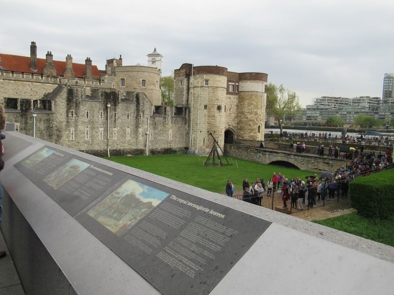
The royal menagrie leaves Marker
| 101 ► United Kingdom, England, Greater London, Tower Hamlets — The royal menagrie leaves — |
| Near Tower Hill at Trinity Square, on the left when traveling west. | |||
| 102 ► United Kingdom, England, Greater London, Tower Hamlets — The Tower in 1700 — |
| Near Tower Hill at Trinity Square, on the left when traveling west. | |||
| 103 ► United Kingdom, England, Greater London, Tower Hamlets — The Tower in flames — |
| Near Tower Hill at Trinity Square, on the left when traveling west. | |||
| 104 ► United Kingdom, England, Greater London, Tower Hamlets — The Tower of London foreshore — |
| Near Tower Hill at Trinity Square, on the left when traveling west. | |||
| 105 ► United Kingdom, England, Greater London, Tower Hamlets — The Tower Wharf — |
| Near Tower Hill at Trinity Square, on the left when traveling west. | |||
| 106 ► United Kingdom, England, Greater London, Tower Hamlets — The Waterloo Barracks — |
| Near Tower Hill close to Trinity Square, on the left when traveling west. | |||
| 107 ► United Kingdom, England, Greater London, Tower Hamlets — The White Tower and Roman City Wall — |
| On Tower Hill at Trinity Square, on the left when traveling west on Tower Hill. | |||
| 108 ► United Kingdom, England, Greater London, Tower Hamlets — The White Tower and Royal Armouries — |
| Near Tower Hill at Trinity Square, on the left when traveling west. | |||
| 109 ► United Kingdom, England, Greater London, Tower Hamlets — Tower Hill Execution Site — |
| Near Trinity Square just north of A100. | |||
| 110 ► United Kingdom, England, Greater London, Tower Hamlets — Western entrance — |
| Near Tower Hill at Trinity Square, on the left when traveling west. | |||
| 111 ► United Kingdom, England, Greater London, Tower Hamlets — Wharfinger Cottage — |
| Near Tower Hill at Trinity Square, on the left when traveling west. | |||
| 112 ► United Kingdom, England, Greater London, Tower Hamlets — White Tower and the Two Princes — |
| Near Tower Hill at Trinity Square, on the left when traveling west. | |||
| 113 ► United Kingdom, England, Hampshire, Winchester — The Fortification of Wolvesey — |
| Near East Links. | |||
| 114 ► United Kingdom, England, Hampshire, Winchester — The Home of Bishop Henry — |
| Near College Street. | |||
| 115 ► United Kingdom, England, Hampshire, Winchester — Welcome to Wolvesey Castle — |
| On College Street, on the left when traveling east. | |||
| 116 ► United Kingdom, England, Kent, Canterbury — Westgate — |
| On St Peter’s Place at Pound Lane, on the right when traveling north on St Peter’s Place. | |||
| 117 ► United Kingdom, England, Kent, Deal — Deal Castle — |
| On Victoria Road (England Route A258) at Deal Castle Road, on the right when traveling north on Victoria Road. | |||
| 118 ► United Kingdom, England, Kent, Dover — Arthur’s Hall — |
| Near Castle Hill Road at Canons Gate Road, on the left when traveling south. | |||
| 119 ► United Kingdom, England, Kent, Dover — Buildings of Dover Castle — |
| Near Castle Hill Road close to Canons Gate Road, on the left when traveling south. | |||
| 120 ► United Kingdom, England, Kent, Dover — Dover’s defences — |
| Near Castle Hill Road at Canons Gate Road, on the left when traveling south. | |||
| 121 ► United Kingdom, England, Kent, Dover — Dover’s early history — |
| Near Castle Hill Road close to Canons Gate Road, on the left when traveling south. | |||
| 122 ► United Kingdom, England, Kent, Dover — Medieval Dover — |
| Near Castle Hill Road at Canons Gate Road, on the left when traveling south. | |||
| 123 ► United Kingdom, England, Kent, Dover — Saluting Platform — |
| Near Castle Hill Road at Canons Gate Road, on the left when traveling south. | |||
| 124 ► United Kingdom, England, Kent, Maidstone — Aragon the Dragon — |
| Near Ashford Road at Route B2163, on the right when traveling east. | |||
| 125 ► United Kingdom, England, Kent, Maidstone — Leeds Castle — |
| Near Ashford Road at Route B2163, on the right when traveling east. | |||
| 126 ► United Kingdom, England, Kent, Maidstone — Leeds Castle — |
| Near Ashford Road at Route B2163, on the right when traveling east. | |||
| 127 ► United Kingdom, England, Kent, Maidstone — Leeds Castle Alterations — |
| Near Ashford Road at Route B2163, on the right when traveling east. | |||
| 128 ► United Kingdom, England, Kent, Maidstone — Main Castle Island — |
| Near Ashford Road at England Route B2163, on the right when traveling east. | |||
| 129 ► United Kingdom, England, Leicester — Castle Motte — Medieval Leicester — Story of Leicester — |
| Near Castle View. | |||
| 130 ► United Kingdom, England, Leicester — Leicester Castle — |
| Near Castle View. | |||
| 131 ► United Kingdom, England, Leicester — Newarke Gateway — |
| On Oxford Street close to Vaughan Way, on the left when traveling north. | |||
| 132 ► United Kingdom, England, Leicestershire, Leicester — The South Gate — |
| Near Vaughan Way at The Newarke, on the left when traveling north. | |||
| 133 ► United Kingdom, England, Medway, Rochester — Rochester Castle Moat — |
| On Boley Hill just east of St. Margaret's Street, on the left when traveling east. | |||
| 134 ► United Kingdom, England, Northumberland, Alnwick — Alnwick Quarters — |
| On The Peth (England Route B6341) at Bailiffgate, on the left when traveling south on The Peth. | |||
| 135 ► United Kingdom, England, Northumberland, Alnwick — Sir Henry Percy Hotspur — |
| Near The Peth (England Route B6341) at Bailiffgate, on the left when traveling south. | |||
| 136 ► United Kingdom, England, Northumberland, Bamburgh — 19th Century Iron Mortar — |
| Near Links Road at Front Street, on the right when traveling north. | |||
| 137 ► United Kingdom, England, Northumberland, Bamburgh — 24 Pounder Cannons — |
| Near Links Road at Front Street, on the right when traveling north. | |||
| 138 ► United Kingdom, England, Northumberland, Bamburgh — 32 Pounder Cannon — |
| Near Links Road at Front Street, on the right when traveling north. | |||
| 139 ► United Kingdom, England, Northumberland, Bamburgh — Bamburgh Castle Bell — |
| Near Links Road at Front Street, on the right when traveling north. | |||
| 140 ► United Kingdom, England, Northumberland, Bamburgh — Bamburgh Castle Coastguard Station — |
| Near Links Road at Front Street, on the right when traveling north. | |||
| 141 ► United Kingdom, England, Northumberland, Bamburgh — Bamburgh’s Recorded History — |
| Near Links Road at Front Street, on the right when traveling north. | |||
| 142 ► United Kingdom, England, Northumberland, Bamburgh — Chapel of St. Peter — |
| Near Links Road at Front Street, on the right when traveling north. | |||
| 143 ► United Kingdom, England, Northumberland, Bamburgh — Home of Kings — Bamburgh Castle — |
| Near Links Road at Front Street, on the right when traveling north. | |||
| 144 ► United Kingdom, England, Northumberland, Bamburgh — Mid-Tower Room — |
| Near Links Road at Front Street, on the right when traveling north. | |||
| 145 ► United Kingdom, England, Northumberland, Bamburgh — Northumbria’s Royal Throne — |
| Near Links Road at Front Street, on the right when traveling north. | |||
| 146 ► United Kingdom, England, Northumberland, Bamburgh — Stocks — |
| Near Links Road at Front Street, on the right when traveling north. | |||
| 147 ► United Kingdom, England, Northumberland, Bamburgh — The Armada Gun — |
| Near Links Road at Front Street, on the right when traveling north. | |||
| 148 ► United Kingdom, England, Northumberland, Bamburgh — The Farne Islands — Bamburgh Castle — |
| Near Links Road at Front Street, on the right when traveling north. | |||
| 149 ► United Kingdom, England, Northumberland, Bardon Mill — Hadrian's Wall — Frontiers of the Roman Empire World Heritage Site — |
| 150 ► United Kingdom, England, Northumberland, Bardon Mill — Steel Rigg — Welcome to Northumberland National Park — |
| Near 68. | |||
| 151 ► United Kingdom, England, Northumberland, Corbridge — Corbridge Roman Site — |
| Near Corchester Lane, 0.8 kilometers west of Stagshaw Road, on the left when traveling west. | |||
| 152 ► United Kingdom, England, Northumberland, Corbridge — The Courtyard Building — |
| Near Corchester Lane, 0.8 kilometers west of Stagshaw Road, on the left when traveling west. | |||
| 153 ► United Kingdom, England, Northumberland, Corbridge — The Early Forts — |
| Near Corchester Lane, 0.8 kilometers west of Stagshaw Road, on the left when traveling west. | |||
| 154 ► United Kingdom, England, Northumberland, Corbridge — The East Military Compound — |
| Near Corchester Lane, 0.8 kilometers west of Stagshaw Road, on the left when traveling west. | |||
| 155 ► United Kingdom, England, Northumberland, Corbridge — The Fountain House — |
| Near Corchester Lane, 0.8 kilometers west of Stagshaw Road, on the left when traveling west. | |||
| 156 ► United Kingdom, England, Northumberland, Corbridge — The Granaries — |
| On Corchester Lane, 0.8 kilometers west of Stagshaw Road, on the left when traveling west. | |||
| 157 ► United Kingdom, England, Northumberland, Corbridge — The Main Street — |
| Near Corchester Lane, 0.8 kilometers west of Stagshaw Road, on the left when traveling west. | |||
| 158 ► United Kingdom, England, Northumberland, Corbridge — The Side Street — |
| Near Corchester Lane at Stagshaw Road, on the left when traveling west. | |||
| 159 ► United Kingdom, England, Northumberland, Corbridge — The West Headquarters Building — |
| Near Corchester Lane, 0.8 kilometers west of Stagshaw Road, on the left when traveling west. | |||
| 160 ► United Kingdom, England, Northumberland, Corbridge — The West Military Compound — |
| Near Corchester Lane, 0.8 kilometers west of Stagshaw Road, on the left when traveling west. | |||
| 161 ► United Kingdom, England, Northumberland, Corbridge — Vicar’s Pele — |
| On Middle Street at Market Place, on the right when traveling north on Middle Street. | |||
| 162 ► United Kingdom, England, Northumberland, Hexham — 16th Century Bastle House — |
| Near England Route B6319, 2.9 kilometers west of North Road, on the right when traveling west. | |||
| 163 ► United Kingdom, England, Northumberland, Hexham — A Changing Fort — |
| Near England Route B6319, 4.7 kilometers west of North Road, on the right when traveling west. | |||
| 164 ► United Kingdom, England, Northumberland, Hexham — A military community — |
| Near road 68, 4 kilometers north of England Route A69, on the left when traveling north. | |||
| 165 ► United Kingdom, England, Northumberland, Hexham — Barracks: the Last Hundred Years at Housesteads — |
| Near Route B6319, 4.7 kilometers west of North Road, on the right when traveling west. | |||
| 166 ► United Kingdom, England, Northumberland, Hexham — Beneath the soil — |
| Near road 68, 4 kilometers north of England Route A69, on the left when traveling north. | |||
| 167 ► United Kingdom, England, Northumberland, Hexham — Chesterholm Museum — |
| Near road 68, 4 kilometers England Route A69, on the left when traveling north. | |||
| 168 ► United Kingdom, England, Northumberland, Hexham — Dolichenum — |
| Near road 68, 4 kilometers north of Route A69, on the left when traveling north. | |||
| 169 ► United Kingdom, England, Northumberland, Hexham — Mediterranean Style in Northern Climes — |
| Near Route B6319, 2.9 kilometers Route A69, on the right when traveling west. | |||
| 170 ► United Kingdom, England, Northumberland, Hexham — North West Quadrant Barracks — |
| Near road 68, 4 kilometers north of Route A69, on the left when traveling north. | |||
| 171 ► United Kingdom, England, Northumberland, Hexham — Roman Pottery Kiln — |
| Near road 68, 4 kilometers north of England Route A69, on the left when traveling north. | |||
| 172 ► United Kingdom, England, Northumberland, Hexham — S.P.Q.R. — |
| Near road 68, 4 kilometers north of Route A69, on the left when traveling north. | |||
| 173 ► United Kingdom, England, Northumberland, Hexham — Severan Circular Huts — |
| Near road 68, 4 kilometers north of Route A69, on the left when traveling north. | |||
| 174 ► United Kingdom, England, Northumberland, Hexham — The Comanding Officer and his House — |
| Near England Route B6319, 4.7 kilometers west of North Road, on the right when traveling west. | |||
| 175 ► United Kingdom, England, Northumberland, Hexham — The Fort and its Design — |
| Near England Route B6319, 4.7 kilometers west of North Road, on the right when traveling west. | |||
| 176 ► United Kingdom, England, Northumberland, Hexham — The Fort Food Supply — |
| Near Route B6319, 2.9 kilometers west of North Road, on the right when traveling west. | |||
| 177 ► United Kingdom, England, Northumberland, Hexham — The heart of the fort — |
| Near road 68, 2.5 kilometers north of England Route A69, on the left when traveling north. | |||
| 178 ► United Kingdom, England, Northumberland, Hexham — The Heart of the Fort — |
| Near England Route B6319, 2.9 kilometers west of North Road, on the right when traveling west. | |||
| 179 ► United Kingdom, England, Northumberland, Hexham — The Milestone — |
| Near road 68, 4 kilometers north of England Route A69, on the left when traveling north. | |||
| 180 ► United Kingdom, England, Northumberland, Hexham — The North Gate — |
| Near Route B6319, 4.7 kilometers west of North Road, on the right when traveling west. | |||
| 181 ► United Kingdom, England, Northumberland, Hexham — The Severan fort — |
| Near road 68, 4 kilometers north of Route A69, on the left when traveling north. | |||
| 182 ► United Kingdom, England, Northumberland, Hexham — The Vicus — |
| Near B6319, 4.7 kilometers west of North Road, on the right when traveling west. | |||
| 183 ► United Kingdom, England, Northumberland, Hexham — The village and fort — |
| Near road 68, 4 kilometers north of England Route A69, on the left when traveling north. | |||
| 184 ► United Kingdom, England, Northumberland, Hexham — The Wall Arrives — |
| Near England Route B6319, 2.9 kilometers west of North Road, on the right when traveling west. | |||
| 185 ► United Kingdom, England, Northumberland, Hexham — Vindolanda Inscriptions — |
| Near road 68, 4 kilometers north of Route A69, on the left when traveling north. | |||
| 186 ► United Kingdom, England, Northumberland, Hexham — Where the Soldiers Lived — |
| Near England Route B6319, 2.9 kilometers west of North Road, on the right when traveling west. | |||
| 187 ► United Kingdom, England, Northumberland, Hexham — Workshops — |
| Near road 68, 4 kilometers north of Route A69, on the left when traveling north. | |||
| 188 ► United Kingdom, England, Northumberland, Morpeth — The Chapel — Warkworth Castle — |
| Near Castle Street at Wellfield, on the left when traveling north. | |||
| 189 ► United Kingdom, England, Northumberland, Morpeth — The Great Hall — Warkworth Castle — |
| Near Castle Street at Wellfield, on the left when traveling north. | |||
| 190 ► United Kingdom, England, Nottinghamshire, Newark-on-Trent — Newark Castle — North Curtain Wall and Gatehouse — |
| 191 ► United Kingdom, England, Nottinghamshire, Newark-on-Trent — Newark Castle — The Halls Range and Riverside Curtain Wall — |
| 192 ► United Kingdom, England, Oxfordshire, Oxford — Archaeology, the Castle Ditch — |
| Near New Road at Oxford Castle, on the left when traveling west. | |||
| 193 ► United Kingdom, England, Oxfordshire, Oxford — New Road — |
| On New Road at Worcester Street, on the right when traveling west on New Road. | |||
| 194 ► United Kingdom, England, Oxfordshire, Oxford — Oxford Castle — |
| On New Road at Oxford Castle, on the left when traveling west on New Road. | |||
| 195 ► United Kingdom, England, Oxfordshire, Oxford — Oxford Castle Timeline — |
| On New Road close to Oxford Castle, on the left when traveling west. | |||
| 196 ► United Kingdom, England, Oxfordshire, Oxford — Prison D Wing — |
| Near New Road at Oxford Castle, on the left when traveling west. | |||
| 197 ► United Kingdom, England, Oxfordshire, Oxford — Prison Debtors’ Tower — |
| Near New Road at Oxford Castle, on the left when traveling west. | |||
| 198 ► United Kingdom, England, Oxfordshire, Oxford — Prison Governor’s House — |
| Near New Road at Oxford Castle, on the left when traveling west. | |||
| 199 ► United Kingdom, England, Oxfordshire, Oxford — The Motte and Bailey — |
| Near New Road at Oxford Castle, on the left when traveling west. | |||
| 200 ► United Kingdom, England, Oxfordshire, Oxford — The Perimeter Wall — |
| Near New Road at Oxford Castle, on the left when traveling west. | |||
257 entries matched your criteria. Entries 101 through 200 are listed above. ⊲ Previous 100 — The final 57 ⊳