On Roosevelt Boulevard at Golf Course Drive, on the right when traveling north on Roosevelt Boulevard.
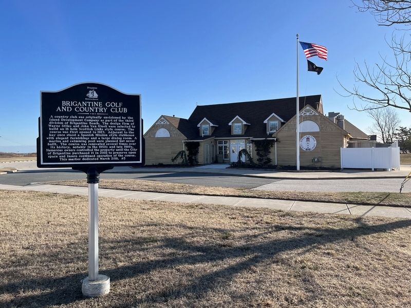
A country club was originally envisioned by the Island Development Company as part of the third division of Brigantine Beach. The design firm of Wayne Stiles and John Van Kleek were selected to build an 18 hole Scottish Links style course. The . . . — — Map (db m190902) HM
The Manor House was built n 1832 by Joseph West for his younger sister, Maria, and her husband, Daniel Estell, as a wedding present. Daniel Estell was the co-owner and operator of the Estellville Glassworks until his death in 1858.
The two and . . . — — Map (db m92368) HM
Built of NJ sandstone by Samuel Richards, Weymouth Ironmaster, the inn and tavern served courthouse and Weymouth Furnace workers, travelers, sea captains and crews. Entered on National Register of Historic Places in 1979. — — Map (db m92343) HM
On Cape May Avenue (New Jersey Route 50) just north of Main Street, on the left when traveling north.
The Presbyterian Church in Mays Landing was constructed between 1841 and 1844 in the Greek Revival Style. Samuel Richards, owner of the Weymouth Furnace, and his wife Anna donated a lot of ground, valued at $100 and centrally located in May's . . . — — Map (db m190886) HM
On Atlantic City Expressway, 7.6 miles east of 12th Street (New Jersey Route 54), in the median.
The original World Trade Center in March 2001. The tower on the left with antenna spire was 1 WTC. The tower on the right was 2 WTC. All seven buildings on the WTC complex are partially visible; refer . . . — — Map (db m153437) HM
Somers Mansion, thought to be the oldest house in Atlantic County, was built in the early 1720’s. The first record of the house is in the Meeting minutes of the Great Egg Harbor/Cape May Society of Friends in 1726 when the group met at the home . . . — — Map (db m64293) HM
On South Somerset Avenue just north of Boardwalk, on the right when traveling north.
Ventnor City Municipal Hall
The present city hall is part a memorial to the veterans of World War I, as dedicated on June 15, 1929, under the auspices of the James Harvey American Legion Post #144. This Tudor-style building, designed by . . . — — Map (db m153603) HM
On S. New Haven Ave. south of Atlantic Ave., on the left when traveling south.
This is the Keystone that was over the main entrance of the Oxford Avenue School. This was Ventnors first school building, built in 1909 and torn down in 1986. Second smaller keystone was over another entry. — — Map (db m190482) HM
On Piermont Road (Route 501), on the right when traveling north.
Built about 1786 by Daniel De Clark, the frame kitchen wing was added in the early 1800’s. De Clark operated a large cattle and dairy farm on 170 acres of land. In 1815 son William was the owner and he sold the house to his grandson, Jacob D.C. . . . — — Map (db m7916) HM
On Durie Avenue at Legion Place, on the right when traveling west on Durie Avenue.
To ease post-WWII housing shortages, the Lustron Corp. of Ohio made an unique house of all pre-fabricated steel parts on an assembly line basis and shipped them directly to owners lots. Harold Hess purchased a Westchester Deluxe model with attached . . . — — Map (db m174139) HM
On Piermont Road (County Route 501) at High Street, on the right when traveling north on Piermont Road.
In 1795 Walter Parcells, a mason, erected this house of local stone on 34 acres of land on what was then known as Closter New Road. Built in the Federal style, it is 1½ stories high with a gambrel style roof. The frame wing was added later and . . . — — Map (db m7915) HM
On County Road (County Route 501) at Westervelt Place, on the left when traveling north on County Road.
The main wing of this house was built in 1808 by Benjamin P. Westervelt who served in the local militia during the Revolution. The site of this house has been continuously owned by the Westervelt family since early colonial times. General Erskine’s . . . — — Map (db m7207) HM
On Park Street, on the right when traveling north.
Built 1872 at “Demarests Station” on the Northern Railroad of New Jersey. Designed by noted architect J. Cleveland Cady, it was considered the “handsomest on the line.” The depot was built of Palisades stone quarried on the . . . — — Map (db m7508) HM
On Grand Avenue (County Route 501) at Tracey Place, on the left when traveling north on Grand Avenue.
Built c. 1800 by John G. Benson, a farmer, and from 1794 to 1797, a captain in the militia. This house, an example of post-Revolutionary War Dutch Colonial architecture, was built on property confiscated by New Jersey from the Reverend Garret . . . — — Map (db m7009) HM
On Dunkerhook Road, on the left when traveling north.
This colonial home was built in the 18th century by a Naugle. He was said to have been a paymaster in Layayette’s Light Division. The house served as a landmark on many Revolutionary War maps. It is believed that Lafayette visited here in 1824. . . . — — Map (db m63050) HM
On Washington Place at Court St., on the left when traveling east on Washington Place.
Erected about 1831 by the Washington Banking Company. The first bank in present Bergen County, it opened in the nearby Mansion House in 1825-26. After the bank failed in 1833, it housed the offices of prominent lawyers and judges. Later the home of . . . — — Map (db m6817) HM
On Court Street at Moore Street, on the right when traveling east on Court Street.
[Bergen County Court House Side]:
James Riely Gordon (1863–1937), noted architect of public buildings used the Beaux Arts style to reflect the power and dignity of American institutions of government and justice. Ground was broken . . . — — Map (db m6869) HM
On Court Street at Moore Street, on the right when traveling east on Court Street.
The Bergen County Jail is an impressive and oppressive building. It has a cruciform plan with a castellated exterior, marked by a heavily corbelled battlement and a squat central octagonal tower. Its fortress style of architecture, a prototype of . . . — — Map (db m62941) HM
Built in 1818, by John I. Hopper in old “Polifly”, this Federal style house stands on land purchased in 1694 by his great-grandfather Hendrick. The farm remained in the Hopper family for seven generations. Slaves lived in the kitchen . . . — — Map (db m6864) HM
On Main Street at Washington Place, on the right when traveling north on Main Street.
Peter Zabriskie built a home here in 1751 which contained fine appointments including Dutch tile fireplaces depicting biblical scenes. Enlarged in 1776, the home was called Mansion House later Mansion Hotel. The structure was demolished in 1945. — — Map (db m62936) HM
On Lafayette Road, on the left when traveling north.
The house and the kitchen wing were built about 1801 by Abraham D. Blauvelt who farmed the land. It came into possession of his niece, Catherine Blauvelt, wife of Richard J. Blauvelt, and remained in the family until 1891. In 1904 Herman . . . — — Map (db m7921) HM
On Harriot Avenue at Lafayette Road, on the left when traveling east on Harriot Avenue.
Frederick Wortendyke owned this land in 1723. It was once part of a large grant called the Tappan Patent. His son Jacob, who owned the homestead during the Revolutionary War, was taken captive in one of many British raids made in the area. Later . . . — — Map (db m8683) HM
On Hillsdale Avenue, on the right when traveling east.
About 1756 Peter Westervelt built a small house, enlarged in 1785, on land of his wife Catlyntje Haring. During the Revolutionary War the farm was raided. Later it was owned by son Henry and his son Aaron, a Freeholder and State Assemblyman. . . . — — Map (db m43786) HM
Near North Franklin Turnpike (County Route 507), on the right when traveling south.
The Rosencrantz family, like other upper-middle class families, worked hard but could sometimes take time to sit on the front porch and visit with neighbors. Some of the stonework visible in this photograph (circa 1890) was original to the 18th . . . — — Map (db m43267) HM
On North Franklin Turnpike (County Route 507), on the right when traveling south.
The Hermitage is a Mid-Nineteenth Century Gothic Revival cottage style villa built on the site of an earlier house. The architect William Ranlett was commissioned in 1847 to renovate the original Colonial-style building by adding a new wing and . . . — — Map (db m43278) HM
Near North Franklin Turnpike (County Route 507), on the right when traveling south.
This area shown (circa 1890) is in the rear of the Hermitage and provided a convenient, covered area for household activities. To Victorians there was a strong connection between homes and children. “It is not for ourselves alone but for the sake . . . — — Map (db m43275) HM
Near North Franklin Turnpike (County Route 507), on the right when traveling south.
Mary Elizabeth Rosencrantz was born in the Hermitage and lived there until she died in 1970 at the age of 85. Unmarried and one of the last descendants of Elijah Rosencrantz who purchased the Hermitage in 1807, she knew the historical value of her . . . — — Map (db m43269) HM
Near North Franklin Turnpike (County Route 507), on the right when traveling south.
William Dayton Rosencrantz, his children William Dayton, Jr. and Mary Elizabeth, and second wife Bessie posed (circa 1890) in front of the well-house which provided water for the Rosencrantz family and for travelers on Franklin Turnpike. The . . . — — Map (db m43279) HM
On North Franklin Turnpike (County Route 507), on the right when traveling south.
has been designated a Registered National Historic Landmark Under the provisions of the Historic Sites Act of August 21, 1935 this site possesses exceptional value in commemorating and illustrating the history of the United States U.S. . . . — — Map (db m43142) HM
On Lakeview Drive, on the right when traveling west.
Located in old English Neighborhood on land purchased by Dirck Vreeland before the Revolution, the homestead stretched between the Hudson River and Overpeck Creek. The stone wing of this house was built about 1786 and later was remodeled. Son . . . — — Map (db m7131) HM
On Riverside Ave at Fern Ave, on the right when traveling north on Riverside Ave.
The first schoolhouse was built on this site in 1804. Located in what then was called New Barbadoes Neck, the land was donated by Jacob Van Winkle “for the sole purpose of erecting a School House”. In 1849 it was replaced by a two-story building. . . . — — Map (db m6733) HM
Near Ramapo Valley Road (U.S. 202) at Darlington Avenue.
In the 1800s, wealthy entrepreneurs from New York City established farm estates in the Ramapo Valley, employing so many people that the properties grew into small hamlets. As the number of children increased, estate owners Alfred B. Darling and . . . — — Map (db m150298) HM
On Ramapo Valley Road (U.S. 202), on the right when traveling south.
Located in “Ramapough” near the site of an Indian trading post, this Dutch Colonial house was built about 1750 by Jacobus Laroe. The small wing was added at a later date, the porch about 1840. Some later owners were Jacobus Bogert who . . . — — Map (db m43801) HM
On West Ramapo Avenue just west of Island Road, on the right when traveling west.
The Ramapo Reformed Church succeeded two German Lutheran meeting houses, ca. 1720-1739. The area was called the “Island". Dutch Calvinists came at mid-century and, in 1785, organized “The Dutch Reformed Congregation at Ramapough in Bergen County". . . . — — Map (db m232646) HM
On Wyckoff Avenue at Pulis Avenue, on the right when traveling north on Wyckoff Avenue.
This 19th-century farmhouse with Colonial Revival features was the home of Garret G. Ackerman (b. 1810 – d. 1870) until his accidental death when he was thrown from his horse-drawn wagon on present Fardale Avenue. The west section of the house . . . — — Map (db m27051) HM
On Forest Road west of Mac Intyre Lane, on the left when traveling east.
The first and largest 2½ story block of this house was constructed by the Valentines, carpenters, and house builders, c. 1820. It features a Greek-Revival doorway, two interior chimneys and a later wraparound porch with Tuscan-style columns. . . . — — Map (db m27054) HM
On Ramapo Valley Road (U.S. 202) at Farmstead Road, on the left when traveling south on Ramapo Valley Road.
Thomas Winter (b. 1820) built this home on family land c. 1844. The style is “vernacular” with some Greek Revival influences, common to the era. Winter married twice and had ten children from 1844 to 1874. This rare, 970 sq. ft. . . . — — Map (db m43896) HM
On Goffle Road, on the right when traveling north on Goffle Road.
This old Dutch sandstone
house, shown on Erskine's
1780 map, was built by
Cornelius Lozier before
the Revolution. South of
it was the grist mill,
known as Lozier's Mill.
Later, when the property
passed to Garret Lydecker,
the area was . . . — — Map (db m51171) HM
On West Grand Avenue at Railroad Avenue, on the left when traveling east on West Grand Avenue.
An example of the "Gravel Wall and Octagon Mode of Building" popularized by Orso S. Fowler in the 1850's, noted for its use of building material, plan of rooms and adaptability to light and ventilation. Built 1855-60 by John Blauvelt, Jr., an . . . — — Map (db m33647) HM
On Tappan Road at Broadway, on the right when traveling north on Tappan Road.
Built about 1890 in the High Victorian style of architecture when Norwood was part of old Harrington Township. Blauvelt was an undertaker and erected the building as a residence. In 1922 it became the home of Charles S. Gray who served as Mayor of . . . — — Map (db m8682) HM
On Franklin Avenue at Ramapo Valley Road (U.S. 202), on the right when traveling west on Franklin Avenue.
This Dutch Colonial house was built by Hendrick Van Allen before the Revolutionary War on a farm that consisted of over two-hundred acres. General George Washington used this house as his Headquarters on July 14-15, 1777, when he moved his troops . . . — — Map (db m12336) HM
On Dogwood Drive at Ramapo Valley Road (U.S. 202), on the right when traveling west on Dogwood Drive.
Built about 1789 by Jacobus S. Demarest, the frame wing was added later. Demarest served in the Revolutionary War. Over the years his farm grew to 180 acres. In 1835 his son, Daniel J. Demarest, inherited the farmhouse. In 1863 it passed to his . . . — — Map (db m12401) HM
On Westwood Avenue, on the right when traveling south.
Built about 1864 by Claudius with a kitchen wing, it has elements of Greek Revival and Italianate styles of architecture. He purchased a half interest in the farm and mill works owned by his brother Nicholas. Their firm was known as the Collignon . . . — — Map (db m7930) HM
This house was built about 1709 by Cosyn Haring, one of the sixteen Tappan patentees. It is an example of early Dutch Colonial architecture found in the Hackensack valley. This house has never been deeded to anyone, having been in the same family . . . — — Map (db m52943) HM
On Old Tappan Road at Leoson Pkwy, on the right when traveling west on Old Tappan Road.
Built about 1836 by John Haring, Jr., the house is an example of Greek Revival architecture and retains many original features. Haring’s homestead was on 14½ acres but he also owned adjacent lands which he farmed for decades. Daughter Sarah . . . — — Map (db m7932) HM
On Old Tappan Road at Orangeburgh Road, on the right when traveling west on Old Tappan Road.
Erected about 1810 on the site of an earlier house, the brick and sandstone center section is Dutch Colonial style, with wings added c. 1820-1875. It was the homestead of Teunis Haring, a farmer and Chosen Freeholder of Bergen County. Later owned . . . — — Map (db m43842) HM
On Kinderkamack Road, 0.1 miles south of Homestead Place, on the right when traveling south.
Built in 1896-1898, the carriage house and stables served the estate of Kimball Chase-Atwood, and later, the Elmer Blauvelt Family. Designed by the prominent architect, Fred W. Wentworth, the buildings, like the mansion, are shingle-style . . . — — Map (db m143637) HM
On Brookside Avenue at Kindermack Road, on the left when traveling east on Brookside Avenue.
Built about 1825 by Richard Teunis Cooper, a chairmaker, on land owned by the family since 1716. This Federal style house, once on a 22 acre farm, is in the Oradell locality formerly known as New Milford. Son John R. Cooper, a master blacksmith, . . . — — Map (db m7550) HM
On Kinderkamack Road (County Route 503), on the left when traveling north.
Small wing built by Abraham J. Van Buskirk about 1820 from earlier c. 1789 house. Federal style main wing built c. 1832-34 for Fanning T. Oakley and wife Hetty Van Buskirk. Later owned by son Abraham V. B. Oakley and wife Eliza Voorhis; their . . . — — Map (db m7551) HM
On Elm Street at New Milford Avenue, on the right when traveling north on Elm Street.
Welcome to the design process for the Van Buskirk Island County Park. On November 19, 2009, Oradell and New Milford residents provided input and imaginative ideas for the park's use at a Design Charrette. These ideas are guiding the Van Buskirk . . . — — Map (db m129876) HM
On Paramus Road, on the left when traveling north.
Built c. 1826, this house combines the Federal style of architecture with that of the earlier Dutch Colonial. Erected by Jacob J. Zabriskie on the site of an earlier home, the farmhouse remained in the Zabriskie family for 132 years. — — Map (db m8334) HM
On W. Midland Avenue, on the left when traveling east.
This sturdy old frame building is a landmark in the community, having served Paramus residents in various ways. Originally School No. 26 of Midland Township, it was converted into a borough hall when Paramus Borough was formed in 1922. In 1959 it . . . — — Map (db m8333) HM
On Paramus Road, on the left when traveling north.
Built by Jacobus Rutan, a farmer, on 32 acres of land about 1794-95. In 1800 his widow and son sold the house to Cornelius H. Zabriskie, a blacksmith and farmer. In 1856 he deeded the house to his grandson, Cornelius Zabriskie Terhune, also a . . . — — Map (db m8336) HM
On Pascack Road at Lakeview Avenue, on the left when traveling north on Pascack Road.
Built about 1800 by John Ackerson and son Garret, this stone house stands on land purchased in 1759. The property was developed during a century of family ownership. A general store was built opposite the house site in 1777 and successive . . . — — Map (db m29883) HM
On Pascack Road, on the right when traveling north.
This barn and the house across the road were at the center of Frederick Wortendyke’s farm. Frederick built them about 1770 on the eve of the American Revolution. He was a “Dutchman” who raised a large family here. He passed the farm on . . . — — Map (db m29933) HM
On Pascack Road, on the right when traveling north.
This pre-Revolutionary Dutch barn was built by the Wortendyke family. Once common in the Hudson River area, the barn is one of the few remaining in this country. Broader than deep, the structure is entirely supported by four H-frames tied with . . . — — Map (db m29886) HM
On Pascack Road at Lang Court, on the left when traveling north on Pascack Road.
Frederick Wortendyke, Jr. built the original sandstone section of this farmhouse in the 1750’s. Located at “Pascack” on land purchased by his father in 1735, the tract included nearly a third of present-day Park Ridge. The homestead was . . . — — Map (db m29885) HM
On Franklin Avenue at Cottage Place, on the right when traveling east on Franklin Avenue.
This building, constructed in 1894, housed all the school children of Ridgewood and vicinity. A petition by the mothers of the village altered the design from wood to brick and stone. One of New Jersey’s first kindergartens was housed here. The . . . — — Map (db m16494) HM
On W. Ridgewood Avenue near 305 W. Ridgewood Avenue, on the right when traveling west.
Built about 1869 in the late Italianate style of architecture, it was the summer home of Joseph H. Chapman who was a Wall St. insurance agent. In 1868 a group of investors laid out streets and house lots and named the development Ridgewood Park. . . . — — Map (db m24986) HM
On W. Ridgewood Avenue at Garber Square, on the left when traveling east on W. Ridgewood Avenue.
Ridgewood Station
Date: 1916
W. W. Drinker and Frank A. Howard, Engineers
Ridgewood Station is a fine, and possibly unique (for New Jersey) example of the Mission Revival style, first popularized in California during the 1890's. Distinctive . . . — — Map (db m108051) HM
On Grove Street at Arcadia Road, on the left when traveling east on Grove Street.
Located on property purchased by Garret Van Dien about 1713, this house was built by a descendant, and is a combination of 18th and 19th century architecture. It has been enlarged over the years and remained in the Van Dien family until 1900. — — Map (db m24987) HM
This Dutch Style sandstone house had stood in New Milford since the Revolution. Faced with demolition it was saved for our country’s heritage by moving it to this site on September 27, 1977. This preservation was accomplished through the combined . . . — — Map (db m7465) HM
On Rockleigh Road, on the left when traveling north.
Built about 1796 by Jacob Concklin, Jr., a “wheelwright”, the house is an example of Dutch Colonial architecture. Erected on the site of an earlier Concklin homestead, it stands on a 166½ acre farm purchased in 1748 by Jacob . . . — — Map (db m52946) HM
On Piermont Road (County Route 501), on the right when traveling south.
An early 19th century example of Dutch Colonial architecture erected by John A. Haring. Small wing added c. 1808; rear stone section built by a Haring about the time of the Revolutionary War. Inherited in 1854 by son Nicholas J. Haring, the . . . — — Map (db m8686) HM
On Rockleigh Road near 31 Rockleigh Road, on the left when traveling north.
Erected by Joseph Dubois in the locality once known as Rockland Neighborhood. South wing built in 1835, with materials from 18th century house of John Gesner. Center section built soon after with Victorian porch and north wing added at a later . . . — — Map (db m8680) HM
On Chestnut Ridge Road near Woodcliff Lake Road, on the right when traveling north.
Built circa 1802 by Abraham P. Ackerman who added stone kitchen wing soon after. Later, son William built frame unit. His son Abraham W., owner in 1875, remodeled house and added mansard roofs. The farmhouse remained in the Ackerman family until . . . — — Map (db m29878) HM
On W. Saddle River Road at E Allendale Road, on the right when traveling south on W. Saddle River Road.
Built around 1835 in the Greek Revival style, it incorporates parts of a late 18th c. home. John D. Ackerman was a miller and his son, David I., was a blacksmith who built a trip hammer forge on the Saddle River opposite the house. His grandson, . . . — — Map (db m29877) HM
Built about 1867 for the Charles J. Everett family, this house was designed by famous architect Richard Morris Hunt in the Swiss Chalet style. Everett was noted as an inventor. In 1919 it became the home of Harvey Dunn, a prominent artist whose . . . — — Map (db m7484) HM
On Westervelt Ave east of Tenafly Road, on the right when traveling east.
This house is a fine example of Dutch Colonial architecture. The south wing of the house was built by Roelof Westervelt in 1745. The land had been purchased by his grandfather, in 1695, from the Lord Proprietores of East Jersey. The central section . . . — — Map (db m7210) HM
On Jefferson Ave south of Newcomb Road, on the left when traveling north.
Stands on land purchased by William P. Christie for 500 pounds for 100 acres. In 1804 he built his home. Following his sudden death, in order to be fair to the many heirs, the house and the land were sold at auction to three buyers. In 1836 Samuel . . . — — Map (db m7209) HM
On Piermont Road, on the right when traveling south.
Built in 1872 when George Huyler donated the land and a third of the cost. Residents and the Northern Railroad of New Jersey shared equally in the balance. Designed in High Victorian Gothic by Architect Daniel T. Atwood, the station opened in 1874 . . . — — Map (db m7211) HM
On Ridgewood Road east of Pascack Road, on the left when traveling east.
Oldest house in Washington Township, built by Nicholas Zabriskie about 1750. Wings added after 1770 and second story frame raised above original native sandstone in 1812. Tradition says house was an Underground Railway depot for escaping slaves . . . — — Map (db m43780) HM
On Pascack Road at Edge Hill Court, on the left when traveling north on Pascack Road.
This sandstone and frame house was built about 1794 by Peter P. Post, a third generation miller from Pompton, who settled here in 1789 and operated a gristmill along nearby Bear Brook. Later owners included the Abraham J. Demarest family who were . . . — — Map (db m43841) HM
On Franklin Avenue at Maple Avenue, on the right when traveling west on Franklin Avenue.
Built in 1824 by Albert Van Voorhees, this Federal home replaced his earlier house. The land, owned by father William since 1720, was called “Wikehoff”. Albert, a veteran of the Revolution and a Justice, deeded the new home to grandson Albert J. . . . — — Map (db m12407) HM
On Wyckoff Avenue, on the right when traveling north.
Once known as the Reformed Dutch Church of Wyckoff, this was the first church to be erected in the Township. It was established by members of Ponds Church at Oakland who lived in this area. They constructed the building of local stone and timber on . . . — — Map (db m12403) HM
On Warren Street (County Road 543) just east of Wilmerton Street, on the left when traveling west.
Built in 1853 - 1855 through Philadelphia architects Frazer, Furness & Hewitt in the Gothic Revival Style, St. Stephen's Episcopal Church was the tallest structure in the area at that time, where it's 220-foot steeple served as a . . . — — Map (db m194819) HM
On West Park Street, 0.1 miles west of Prince Street, on the left when traveling west.
The land at the confluence of Crosswicks Creek and the Delaware River was once part of a vast estate created by Joseph Bonaparte, elder brother of Napoleon. During Napoleon's brief reign as Emperor of France, Joseph was appointed King of Naples . . . — — Map (db m160165) HM
On High Street south of West Pearl Street, on the right when traveling south.
Built by master bricklayer John Hoskins, Jr., the Federal-Style House is constructed of Flemish Bond brick. The facade focal point is the broken pediment entry with paneled pilasters, and round arched fanlight. Restored in 1983, it typifies 18th . . . — — Map (db m160102) HM
On Wood Street at Riverbank, on the right when traveling north on Wood Street.
25-yr. restoration 1983-2008
Home of Civil War "Boy General", Edward Burd Grubb
The Cottage 1872
General Edward Burd Grubb
November 13, 1841 - July 7, 1913
• Born, Burlington, NJ; Graduated Burlington College 1860
• Enlisted May . . . — — Map (db m35900) HM
On Conrow Road, on the right when traveling north.
The original section was built in 1733 by Darling Conrow. A larger section was added in 1751 when he married his wife Deliverance This home is the oldest structure in Delran Township. — — Map (db m102593) HM
On Main Street at 7th Avenue, on the right when traveling west on Main Street.
Built in 1915, entertainment in the auditorium included vaudeville shows, minstrels, boxing matches and movies. It was one of the first centrally air-conditioned buildings in the United States. — — Map (db m237170) HM
Thomas & Mary Even House has been placed on the National Register of Historic Places by the United States Department of the Interior. Built 1785. — — Map (db m79432) HM
Thomas Hollinshead House has been placed on the National Register of Historic Places by the United States Department of the Interior.
Built 1776 — — Map (db m79415) HM
On Branch Street east of Charles Street, on the left when traveling east.
This home was built by Albert and Belle Ballinger in 1911. All construction materials were shipped in two freight cars on the rail line that used to run through Mt. Holly to Medford. — — Map (db m44718) HM
On Taunton Blvd at Falls Road, on the left when traveling north on Taunton Blvd.
In 1920 Lake Pine was a cranberry bog and Taunton Blvd was a sand road. This log cabin, built in 1926, was converted from a summer cottage to year-round, c. 1950. — — Map (db m45022) HM
On N Main Street (County Route 541) at Cedar Street, on the right when traveling south on N Main Street.
Dr. Henry P. Ely built the house about 1844. The mansard roof was added after a fire in 1893. This 2 and ½ story home shows fine workmanship both inside and outside the building. — — Map (db m44717) HM
On Bank Street at Charles Street, on the right when traveling east on Bank Street.
Jacob Prickett built this home in 1827. Many windows have early glass. Original corner fireplaces in the living and dining rooms still operate efficiently. — — Map (db m44736) HM
On Christopher Mill Road, on the right when traveling west.
Now called Sandy Run. This typical colonial glazed brick front home was built in 1772. Restoration was faithfully accomplished in recent years.
1847-1997 — — Map (db m45023) HM
On S Main Street (County Route 541) south of Bank Street, on the right when traveling north.
Isaac Stokes built this brick house about 1813. Half of the two-story upper level is an early sun room addition. This historic building was restored in the year 2000. — — Map (db m44685) HM
On S Main Street (County Route 541) north of South Street, on the right when traveling north.
This classic 18th century Georgian house of Flemish Bond brick was built c. 1785. Note the belt coursing on the 2nd floor and the watertable brick details on the first floor. — — Map (db m44688) HM
On N Main Street (County Route 541) at Marlton Pike (New Jersey Route 70), on the right when traveling north on N Main Street.
This 1908 late Victorian was home to Albert and Anna Kirby, 1925-1952. He was Master of the Masons, Building and Loan President and a partner in Kirby Brothers until 1945. — — Map (db m44677) HM
On Branin Road at Chapel Avenue, on the right when traveling south on Branin Road.
This 1790’s farmhouse was built by John Peacock. The homestead has been continuously in use as an operating farm since that time. — — Map (db m44976) HM
On Union Street west of Allen Avenue, on the right when traveling west.
This home was built c. 1847. Small corner fireplaces heated the living room and the bedroom above. The 1961 addition blends well with the original architecture. — — Map (db m44773) HM
On Branch Street, on the left when traveling east.
Henry Stackhouse built this home of salt box design c. 1815. The front porch was added later. The cedar siding resists the elements without needing to be painted. — — Map (db m44726) HM
On Fostertown Road north of Church Road, on the right when traveling north.
This early simply detailed frame house was the home of the sawmill foreman at the mill complex. With the mill and the "Miller’s House" it is on the National Register. — — Map (db m44657) HM
On Branch Street at Broad Street, on the right when traveling east on Branch Street.
This Federal style brick home was built in 1830 for merchant Stacy Prickett. Legendary school mistress Bess Cowperthwaite, lived here in the early 1900's. — — Map (db m44720) HM
On S Main Stree (County Route 541) south of South Street, on the right when traveling south.
Isaac Stratton, son of Mark Stratton, in c. 1760 built this Flemish Bond brick home. It was probably built in two sections. In 1795 Robert Braddock purchased the property. — — Map (db m44772) HM
On Medford/Mt Holly Road (County Route 541) at Setter Club Road, on the right when traveling south on Medford/Mt Holly Road.
This, the second oldest home in Medford, was built in 1732. The Flemish Bond brick home remained in the Wilkins family until c. 1915, when it was sold to the English Setter Club. — — Map (db m45020) HM
287 entries matched your criteria. The first 100 are listed above. Next 100 ⊳