On Prospect Street Northwest at 34th Street Northwest, on the left when traveling west on Prospect Street Northwest. Reported damaged.
The early mansions of wealthy ship owners, merchants and land speculators in this part of Georgetown were built high above the Potomac River with fine views, or prospects, of the harbor filled with ships and the wilds of Virginia on the other . . . — — Map (db m113401) HM
On 30th Street Northwest just south of Dumbarton Street Northwest, on the right when traveling north.
Federal style brick house built for Col. Charles Beatty, prominent leader in the Revolutionary War and owner of ferry between Georgetown and Rosslyn; 1806-22 owned by Nicholas Hedges; also residence of merchant Thomas Hyde and son Anthony Hyde, . . . — — Map (db m248781) HM
On Prospect Street Northwest at 33rd Street Northwest, on the right when traveling west on Prospect Street Northwest.
Georgetown has been a performance hub for musicians in a wide range of popular genres — jazz, folk, blues, bluegrass, country, and rock.
During the 1960s and 1970s the Cellar Door, at the corner of 34th and M Streets, featured artists . . . — — Map (db m112123) HM
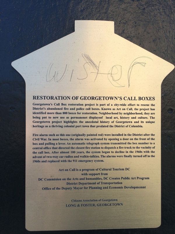
On Olive Street Northwest west of 27th Street Northwest, on the right when traveling east.
c. 1869 Erected by Edgar Murphy, prominent African-American carpenter.
1948 - 1961 Home of Julia Child, famous chef, author and television personality.
1970 Renovated by Hugh Newell Jacobson, renowned architect. . . . — — Map (db m241118) HM
On Dent Place Northwest just west of 33rd Street Northwest, on the right when traveling west.
Yarrow Mamout, born in 1736, arrived in Annapolis in 1752 on the Elijah and served the Beall family until 1796. His name indicates he was Fulani, an educated devout Muslim, he could read and write in Arabic. Freed at age 60, he used money . . . — — Map (db m187427) HM
On 36th Street Northwest south of P Street Northwest, on the right when traveling north.
In 1821, George MaHorney, a bricklayer, built this two room, two story frame "laborer's cottage." William W. Corcoran, a founder of the Corcoran and Riggs Bank and the Corcoran Gallery of Art, owned the property from 1853, through the Civil War, . . . — — Map (db m112144) HM
On O Street Northwest just east of Wisconsin Avenue Northwest.
Capable of housing over 300 horses in its stables in the rear, Montgomery Tavern, at 1363-1365 Wisconsin, catered to farmers looking to buy the enslaved at John Beattie's Auction. The enslaved were held in a pen on O Street that stretched from the . . . — — Map (db m234905) HM
On Thomas Jefferson Street Northwest south of M Street Northwest, on the left when traveling north.
Mules were the "engines" for the canal boats. Normally, a boat captain had four mules. Two worked while two rested in their stall in the front of the boat. Captains usually cared for their mules as if they were part of the family. In the canal's . . . — — Map (db m113416) HM
On M Street Northwest at Thomas Jefferson Street Northwest, on the right when traveling west on M Street Northwest. Reported permanently removed.
The Old Stone House, part of the Landmark District of Georgetown, is the only surviving pre-Revolutionary building in the capital. The house stands on its original site, lot #3, one of eighty lots surveyed in the port of Georgetown in 1751. . . . — — Map (db m61944) HM
Near R Street Northwest at Avon Place Northwest, on the left when traveling east.
Here the Richard Parrott Ropewalk manufactured rope and rigging used on sailing vessels that plied their trade in old Georgetown through the early 19th Century.
The ropewalk receives its name from the long path used for the laying out of . . . — — Map (db m68712) HM
On 30th Street Northwest north of M Street Northwest, on the right when traveling south.
Foundation for Preservation of Historic Georgetown Easement acquired October, 1975 Accepted, March, 1976, by National Trust for Historic Preservation Additional marker: 1210 30th Street, N.W. Andrew Ross Tenant House II Built by Andrew Ross . . . — — Map (db m97705) HM
On Library Walk just west of Tondorf Road, on the left when traveling west.
The Leo O'Donovan Dining Hall building achieved LEED Silver certification following renovations in 2017. The building features energy-efficient design such as motion-sensored lighting to save energy when rooms are unoccupied and daylight-sensing . . . — — Map (db m212204) HM
On 30th Street Northwest, 0.1 miles south of M Street Northwest, on the right when traveling south.
Built between 1856 and 1866 as a machine shop by William T. Duvall, the Foundry is typical of commercial structures of that period. Duvall purchased the land from Thomas Beall, a grandson of Ninian Beall who was one of Georgetown's first settlers . . . — — Map (db m230153) HM
On 31st Street Northwest at C&O Canal Towpath Northwest, on the left when traveling south on 31st Street Northwest. Reported permanently removed.
The Georgetown House is closely linked with the history of the Chesapeake & Ohio Canal. The building was constructed about 1830 by the Chesapeake & Ohio Canal Co. for use as a storage room. Later it became a tavern but shortly thereafter turned into . . . — — Map (db m111008) HM
On Chesapeake and Ohio Canal Towpath just east of 31st Street Northwest, on the right when traveling west.
The Georgetown House is closely linked with the history of the Chesapeake & Ohio Canal. The building was constructed about 1830 by the Chesapeake & Ohio Canal Co. for use as a storage room. Later it became a tavern, but shortly thereafter turned . . . — — Map (db m248769) HM
On 31st Street Northwest at Chesapeake and Ohio Canal Towpath, on the right when traveling north on 31st Street Northwest.
The Georgetown House is closely linked with the history of the Chesapeake & Ohio Canal. The building was constructed about 1830 by the Chesapeake & Ohio Canal Co. for use as a storage room. Later it became a tavern, but shortly thereafter turned . . . — — Map (db m248770) HM
On 31st Street Northwest south of M Street Northwest, on the left when traveling north.
Canal Square has seen more than century and a half of change in Georgetown. It is a typical brick and fieldstone industrial structure built to facilitate barge traffic on the Chesapeake and Ohio (C&O) Canal. Necessary for westward expansion, . . . — — Map (db m113418) HM
On M Street Northwest west of 31st Street Northwest, on the right when traveling east.
Canal Square has seen more than a century and a half of change in Georgetown. It is a typical brick and fieldstone industrial structure built to facilitate barge traffic on the Chesapeake & Ohio (C&O) Canal. Necessary for westward expansion, canals . . . — — Map (db m240113) HM
On M Street Northwest just west of Thomas Jefferson Street Northwest, on the right when traveling west.
The scene before, beside, and behind you has changed a lot over time. Part of the stone structure on your left faced quiet, residential Bridge Street in a busy port city in Maryland when built in 1766. By the late 1800s, Bridge Street became M . . . — — Map (db m186612) HM
Near Virginia Avenue Northwest just west of Rock Creek and Potomac Parkway Northwest, on the right when traveling west.
The 184.5-mile-long Chesapeake and Ohio Canal begins at the Tide Lock and ends at Cumberland, Maryland. Here canal boats entered the canal to bypass mountains, swift currents, and shallows. Boats exited the Tide Lock into the Potomac River to . . . — — Map (db m144180) HM
On P Street Northwest west of 23rd Street Northwest.
In 1608 Captain John Smith sailed up the Potomac, the first European to lay eyes on this site. At that time, ships could sail up to this point, and beautiful bluffs led down to the water. Algonquin Indians lived here in great numbers, drawn by . . . — — Map (db m110015) HM
On M Street Northwest at 34th Street Northwest, on the right when traveling east on M Street Northwest.
In 1805, Francis Scott key, his family, and their enslaved servants moved into a two-story brick house 200 feet from here. A rising lawyer, Key had a small addition next to his home that served as his law office. During the next 25 years, Key . . . — — Map (db m237632) HM
On Prospect Street Northwest just east of Bank Alley Northwest, on the right when traveling west.
James Wormley, born a free African American in 1819, worked in his family's Hackney carriage business and became a prominent businessman and advocate for education. Georgetown spent $70 on African American education in 1862. After the war, the . . . — — Map (db m234902) HM
On Beecher Street Northwest at Huidikoper Place Northwest on Beecher Street Northwest.
Dischord Records is a Washington, D.C. independent record label born right here on Beecher Street in 1980. The label focuses on the independent punk music scene in the Washington area and offers musicians an alternative to major labels. By . . . — — Map (db m113373) HM
On Constitution Avenue Northwest (Alternate U.S. 1) west of 4th Street Northwest, on the right when traveling west.
A bronze likeness of Chief Justice John Marshall, visible on your way to the next Heritage Trail sign, keeps watch over John Marshall Park to your right. Marshall is remembered for molding the U.S. Supreme Court into today's authoritative body. . . . — — Map (db m56495) HM
On 3rd Street Northwest at Florida Avenue Northwest, on the right when traveling north on 3rd Street Northwest.
Before there was a LeDroit Park, map engraver David McClelland owned a mansion on the property across Rhode Island Avenue. When the Civil War broke out in April 1861, McClelland possessed a detailed map of Washington that suddenly had great . . . — — Map (db m130844) HM
On 14th Street Northwest at Church Street Northwest, on the left when traveling north on 14th Street Northwest.
Etched into the corner of the building next to this sign are the names of cars and trucks sold here back when showrooms lined this stretch of 14th Street. Hurley Motor Company, which opened here in 1920, sold Milwaukee-made Nash cars and . . . — — Map (db m110913) HM
On 14th Street Northwest at Rhode Island Avenue Northwest when traveling south on 14th Street Northwest.
After the Civil Disturbances following the assassination of the Reverend Dr. Martin Luther King, Jr., in 1968, 14th Street appeared largely abandoned by day. By night, however, residents witnessed scenes of the “world's oldest . . . — — Map (db m130859) HM
On 14th Street Northwest at Thomas Circle Northwest when traveling south on 14th Street Northwest. Reported damaged.
Through The 1960s President Lyndon B. Johnson and his family worshipped across the street to your left at National City Christian Church. The First Family sat near the front in the pew deemed safest by their Secret Service agents. The church . . . — — Map (db m130858) HM
On 14th Street Northwest at P Street Northwest when traveling north on 14th Street Northwest.
The Studio Theatre, on the corner of 14th and P Streets since 1987, anchors the Logan Circle/14th Street artistic community. The theatre, founded by director and educator Joy Zinoman and set designer Russell Metheny in 1978, originally rented . . . — — Map (db m130860) HM
On 5th Street Northwest at Sheridan Street Northwest, on the left when traveling north on 5th Street Northwest.
The middle school across 5th Street is named in honor of civil rights leader Ida B. Wells, one of the founders of the NAACP in 1909. Before that, she was a respected investigative journalist, co-owning and writing for the Memphis Free Speech and . . . — — Map (db m197720) HM
On Wisconsin Avenue Northwest at Macomb Street Northwest, on the right when traveling south on Wisconsin Avenue Northwest.
As Washington expanded to the Northwest in the 1920s, modest homes were built on farmland in an area known first as Fairview Heights and then as Cathedral Heights, north of Fulton Street and west of Wisconsin Avenue. A Greek family recognized the . . . — — Map (db m120510) HM
On Pierce Mill Road Northwest at Park Road Northwest, on the right when traveling north on Pierce Mill Road Northwest.
Like the Latino immigrants of recent times, Europeans left the political and economic hardships of home for a better life in the United States. Following the 1948 communist coup of Czechoslovakia a "Czech Row" or "Prague Road" enclave . . . — — Map (db m152976) HM
On Mount Pleasant Street Northwest just north of Lamont Street Northwest, on the right when traveling south.
In 1903 a street car line arrived on Mt. Pleasant Street and so did new businesses. In this block were Sophia Weiss's notions shop, Domenico Pappalardo's shoe shop, and Lee Sing's laundry. The block's first commercial building (3215) was . . . — — Map (db m130880) HM
On Mount Pleasant Street Northwest at Kenyon Street Northwest, on the right when traveling south on Mount Pleasant Street Northwest.
During the second half of the 20th century, housing in Mount Pleasant was relatively affordable. Recent immigrants, students, young professionals, and families from diverse economic backgrounds populated the neighborhood. In 1986, residents . . . — — Map (db m130883) HM
On Mount Pleasant Street Northwest at Lamont Street Northwest, on the right when traveling south on Mount Pleasant Street Northwest.
Lamont Park, across from the number 42 bus stop, was once the turnaround for the numbers 40 and 42 streetcars. Back in the 1940s, "when the conductor called 'end of the line,' passengers stepped onto a yellow wooden platform," recalled former . . . — — Map (db m130881) HM
On Mount Pleasant Street Northwest south of Kilbourne Place Northwest.
The 1960s saw this neighborhood develop a Latino presence, and this became its Main Street. The storefront at 3161 Mt. Pleasant Street once housed Casa Diloné , the first bodega (grocery) here. From 1962 until 1998, Casa Diloné sold . . . — — Map (db m130882) HM
On 4th Street Northwest at New York Avenue Northwest (U.S. 50), on the right when traveling south on 4th Street Northwest.
The wooden chapel here was completed in 1857 as a mission of the McKendree Methodist Church. Known as Fletcher Chapel, it may have been a stop on the Underground Railroad.
Washington's Anti-Saloon League began meeting at Fletcher Chapel . . . — — Map (db m130898) HM
On L Street Northwest at 7th Street Northwest, on the right when traveling east on L Street Northwest.
When Northern Liberty Market opened on Mount Vernon Square in 1846, small businesses soon followed. By 1900 they catered to everyday needs and formed a bargain district in comparison to downtown's fancy department stores.
Many stores . . . — — Map (db m130900) HM
On L Street Northwest at 5th Street Northwest, on the right when traveling west on L Street Northwest.
After this neighborhood's original Northern Liberty Market on Mount Vernon Square was razed in 1872, a new Northern Liberty Market was built along Fifth between K and L streets. When owners decided that fresh farm products weren't drawing . . . — — Map (db m130899) HM
On Wisconsin Avenue Northwest at Warren Street Northwest, on the right when traveling west on Wisconsin Avenue Northwest.
Security and style came to Tenleytown in 1900, when Engine House No. 20 opened across from Wisconsin Avenue. No longer would fire fighters have to come all the way from Georgetown to extinguish blazes in Tenleytown's wood-frame houses. Opened . . . — — Map (db m147297) HM
On Van Ness Street Northwest west of Reno Road Northwest, on the left when traveling west.
Celebrated hotelier James Wormley (1819-1884) and his family owned at least two country houses (since razed) on ten acres here during the 1870s and 1880s. This plaque marks approximately the southeast corner of the property.
As a young man . . . — — Map (db m126974) HM
On Georgia Avenue Northwest (U.S. 29) at Kenyon Street Northwest, on the right when traveling south on Georgia Avenue Northwest. Reported missing.
"Innumerable colored Chinese lanterns ... shedding that dim uncertain light which is the delight of lovers and the poetry of beer drinking"
— Washington Post, June 1879
Back when this area was open . . . — — Map (db m99221) HM
On Georgia Avenue Northwest (U.S. 29) at Park Road Northwest, on the right when traveling south on Georgia Avenue Northwest.
Braving a blizzard in February 1936, eager customers lined up to experience a modern, self-service, cash-only supermarket. Nehemiah Cohen and Samuel Lehrman’s Giant Food here on Georgia Avenue was the chain’s first. Although the Memphis-born . . . — — Map (db m130768) HM
On E Street Northwest west of 7th Street Northwest, on the right when traveling west.
[The Great Seal of the United States]
In 1800, the building erected on this site by Samuel Blodget was the scene of the first theatrical performance given in Washington.
From 1812 to 1836 it sheltered the city post office and, for part of . . . — — Map (db m103077) HM
On F Street Northwest at 10th Street Northwest, on the right when traveling west on F Street Northwest. Reported permanently removed.
"Alvin, Washington, D.C., is the place for us."
So wrote Samuel Walter Woodward to his business partner, Alvin Lothrop, in 1879. The young entrepreneurs were looking for a new location for their innovative dry . . . — — Map (db m37223) HM
On F Street Northwest west of 10th Street Northwest, on the right when traveling west.
"Alvin, Washington, D.C., is the place for us."
So wrote Samuel Walter Woodward to his business partner, Alvin Lathrop, in 1879. The young Massachusetts entrepreneurs were looking for a new location for their . . . — — Map (db m211830) HM
On Pennsylvania Avenue Northwest west of 6th Street Northwest (U.S. 1), on the right when traveling west.
On this site in 1814, "The Star-Spangled Banner" was first sung in public. The most famous of several hotels on this block was Brown's Marble Hotel (1851-1935), an innovative Greek Revival landmark, where John Tyler and Abraham Lincoln were guests. . . . — — Map (db m66714) HM
On 13th Street Northwest at G Street Northwest, on the right when traveling north on 13th Street Northwest.
Welcome to downtown Washington, DC — an area rich in history, culture, and places to see. You will enjoy visiting the following sites located in the vicinity of this sign.
Clockwise from top left:
St. John's Church
Every . . . — — Map (db m113345) HM
On F Street Northwest west of 12th Street Northwest, on the right when traveling east.
Welcome to downtown Washington, DC — an area rich in history, culture, and places to see. You will enjoy visiting the following sites in the vicinity of this sign.
[Clockwise from top left:]
Old Post Office Pavilion
The . . . — — Map (db m114658) HM
On 6th Street Northwest at Indiana Avenue Northwest, on the right when traveling south on 6th Street Northwest.
To your right at the end of Indiana Avenue is Washington's first City Hall/Courthouse. Across Sixth Street is the H. Carl Moultrie I Courthouse, a successor to the original courthouse. The Old City Hall/Courthouse opened in 1822, with . . . — — Map (db m56124) HM
On F Street Northwest east of 8th Street Northwest, on the right when traveling east.
General Post Office has been designated a Registered National Historic Landmark under the provisions of the Historic Sites Act of August 21, 1935. This site possesses exceptional value in commemorating or illustrating the history of the . . . — — Map (db m28536) HM
On 11th Street Northwest near F Street Northwest, on the right when traveling south.
This Plaque is Dedicated to
John J. Donovan, Jr.
who was a leading figure in Washington, D.C. commercial real estate development for over three decades (mostly with Oliver Carr Companies) until his retirement in 2005. John directed the design . . . — — Map (db m40992) HM
Near 15th Street Northwest north of Pennsylvania Avenue Northwest, on the right when traveling north.
“All my life I have had a love affair with the City of Washington.”
In a time of racial strife he brought reconciliation and mutual respect.
In the struggle between management and labor he worked for reason and moderation. In a marketplace . . . — — Map (db m92230) HM
On 7th Street Northwest at G Street Northwest, on the left when traveling north on 7th Street Northwest.
Jonathan Borofsky's monumental silhouette of a man carrying a briefcase portrays an urban Everyman. The artist was inspired in 1979 by a newspaper advertisement for men's suits and subsequently made this archetypal office worker a recurring . . . — — Map (db m113217) HM
On G Street Northwest at 14th Street Northwest, on the right when traveling west on G Street Northwest.
The chasm between the principles upon which the government was founded, in which it still professes to believe, and those which are daily practiced under the protection of the flag, yawns wide and deep
Mary Church . . . — — Map (db m141277) HM
On 10th Street Northwest at Pennsylvania Avenue Northwest, on the right when traveling south on 10th Street Northwest.
"Main Street" for the city and the nation
Just a few steps ahead is Pennsylvania Avenue, the inaugural parade route for every president since Thomas Jefferson and "Main Street" for local Washington since the . . . — — Map (db m211829) HM
On F Street Northwest at 7th Street Northwest, on the right when traveling west on F Street Northwest.
This tree has seen many changes.
Planted around 1905 on the grounds of what was then the U.S. Patent Office Building, it has slowly grown as the city has developed and transformed around it.
A rare, large, local specimen of a . . . — — Map (db m202449) HM
On Pennsylvania Avenue Northwest, 0.1 miles 14th Street Northwest (U.S. 1), on the right when traveling west.
The United States Court of Claims held its first meeting in "Willard's Hotel" on this site on May 11, 1855. The court was established to allow citizens to sue the U.S. Government. In 1861, President Lincoln wrote of the court:
"It is as . . . — — Map (db m6587) HM
On Pennsylvania Avenue Northwest east of 14th Street Northwest, on the right when traveling west.
The Washington Post was published at this site for more than half a century, from October 1893 to December 1950–reporting then, as now, the events large and small that touch the lives of the citizens of the capital city, the nation and the . . . — — Map (db m155058) HM
On 10th Street Northwest south of G Street Northwest, on the right when traveling south.
Built in 1902, the original Woodward & Lothrop "Woodies" Department Store fronting on G Street was designed by nationally recognized architect Henry Ives Cobb and remains a striking example of the Gilded Age in Washington, DC. The first two . . . — — Map (db m131773) HM
On G Street Northwest at 10th Street Northwest, on the left when traveling west on G Street Northwest.
Built in 1902, the original Woodward & Lothrop "Woodies" Department Store fronting on G Street was designed by nationally recognized architect Henry Ives Cobb and remains a striking example of the Gilded Age in Washington, DC. The first two . . . — — Map (db m211833) HM
On G Street Northwest west of 10th Street Northwest, on the left when traveling west.
Built in 1902, the original Woodward & Lothrop "Woodies" Department Store fronting on G Street was designed by nationally recognized architect Henry Ives Cobb and remains a striking example of the Gilded Age in Washington, DC. The first two . . . — — Map (db m211834) HM
On G Street Northwest just east of 11th Street Northwest, on the right when traveling east.
Built in 1902, the original Woodward & Lothrop "Woodies" Department Store fronting on G Street was designed by nationally recognized architect Henry Ives Cobb and remains a striking example of the Gilded Age in Washington, DC. The first two . . . — — Map (db m211835) HM
On Georgia Avenue Northwest (U.S. 29) south of Randolph Street Northwest, on the right when traveling north.
Billy Simpson's provided DC's African American community with an upscale venue for dining and socializing in the period when segregation was ending and African Americans claimed a larger role in city affairs. The restaurant (open 1956-1978) . . . — — Map (db m66181) HM
On Georgia Avenue Northwest (U.S. 29) south of Girard Street Northwest, on the left when traveling north.
With its Afro-centric shops and connections to Howard University, this stretch of Georgia Avenue has been called the “Nile Valley.” Blue Nile Botanicals opened first at 2826 Georgia in 1977. Hodari Ali, a former editor of Howard’s . . . — — Map (db m130761) HM
On 6th Street Northwest south of Howard Place Northwest, on the right when traveling south.
Andrew F. Hilyer (1858-1925) fought racism and promoted the "moral, material, and financial interests" of African Americans through the Union League of the District of Columbia, which he co-founded in 1892. Hilyer's Union League Directory . . . — — Map (db m111803) HM
On Euclid Street Northwest west of Georgia Avenue Northwest (U.S. 29), on the left when traveling east.
During the Civil War, thousands of once-enslaved people crowded into DC, desperate for shelter, work, and protection. Most vulnerable were orphans and children separated from their families. In 1863 the National Association for the Relief of . . . — — Map (db m130762) HM
On Georgia Avenue Northwest (U.S. 29) at Barry Place Northwest, on the right when traveling south on Georgia Avenue Northwest.
The area west of this spot once was an Irish and German immigrant neighborhood known as “Cowtown.” That's because, before 1871, cows, pigs, and sheep roamed freely here, while those kept in Washington City, south of Boundary Street (today's . . . — — Map (db m130763) HM
On Georgia Avenue Northwest (U.S. 29) at Bryant Street Northwest, on the right when traveling south on Georgia Avenue Northwest.
Back in the '60s, everyone came to Murph's.
Ed Murphy's Supper Club, that is, located across Georgia Avenue from 1963 to 1975. In the beginning suits and ties were mandatory for the club's highpowered male patrons. But as the Black Power . . . — — Map (db m130773) HM
Adams Mill, a flour mill built by Benjamin Stoddert between 1795 and 1799, was one of eight large mills along Rock Creek Park. Originally it was named Columbian Mill in honor of the newly created District of Columbia. The brick mill was 50 × 54 . . . — — Map (db m210141) HM
On Beach Drive Northwest north of Broad Branch Road Northwest, on the left when traveling north. Reported damaged.
This is the site where Blagden and Argyle mills once stood, two of the twenty-six mills that once flourished along Rock Creek. If you look close, you can still see part of the millrace and the mill road. The exact date of the construction of these . . . — — Map (db m120438) HM
On Tilden Street Northwest west of Beach Drive Northwest, on the right when traveling west.
Peirce Mill Dam was completed in 1906 to create a scenic waterfall on Rock Creek. Since its construction, the dam has prevented spawning herring and other migratory and resident fish from swimming further upstream. A Denil fishway was installed . . . — — Map (db m70670) HM
On Klingle Road Northwest west of Porter Street Northwest.
Welcome to the Klingle Valley Trail, a place for peaceful public recreation. This 0.7-mile trail is a steady, moderate incline through a small wooded stream valley leading to the rugged and picturesque Rock Creek. This trail is built on the remains . . . — — Map (db m111879) HM
Near Tilden Street Northwest west of Beach Drive Northwest, on the right when traveling west.
Peirce Mill represents the beginnings of the Industrial Revolution in America. For centuries, small water-powered mills had ground grain into flour, using human labor in every step of the process. This 1829 mill, on the other hand, was a mechanized . . . — — Map (db m125275) HM
Near Tilden Street Northwest west of Beach Drive Northwest, on the right when traveling west.
Even in the mill's heyday, the Peirce family ran a diversified farm. They grew vegetables, tended bees, raised livestock for meat and dairy and cultivated fields of wheat, corn, rye, and oats. On this hillside they maintained a substantial . . . — — Map (db m99415) HM
On Spring of Freedom Street Northwest east of Shoemaker Street Northwest, on the left when traveling south.
Welcome to Peirce Mill, a National Park Service site within Rock Creek Park. This land was once part of a large complex of buildings and fields, marking the historical intersection of the agricultural and industrial ages. Explore and enjoy. . . . — — Map (db m114362) HM
Near Williamsburg Lane Northwest north of Porter Street Northwest, on the left when traveling south.
During the 19th century, the majority of the land now known as Rock Creek Park was owned by Isaac Peirce, one of Washington's most prominent land holders and mill owners. It was here that Isaac's son, Joshua Peirce, constructed his home in 1823 on . . . — — Map (db m97976) HM
Near Tilden Street Northwest west of Beach Drive Northwest, on the right when traveling west.
Pierce Plantation 1820-1840Cultivated fields and orchards spread out on the more than 1,200-acre tract above the creek. The spring house, family home, distillery, and flour mill remains as evidence of this large working estate along Rock Creek. . . . — — Map (db m99396) HM
Near Tilden Street Northwest west of Beach Drive Northwest, on the right when traveling west.
At one time, Rock Creek hosted a large number of flour mills, saw mills, and other industries. The force of the creek's waters, dropping more than 160 feet over 33 miles, gave the mills their power. The region's farms provided abundant raw . . . — — Map (db m80114) HM
On Tilden Street Northwest west of Beach Drive Northwest, on the right when traveling west.
The stone mill was an important part of the Peirce family's business. Like most farms of the 1800s, this was also a diversified and constantly evolving operation. The family managed hundreds of acres devoted to fields, pastures, and orchards. A . . . — — Map (db m79643) HM
On Rhode Island Avenue Northwest (U.S. 29) at 10th Street Northwest, on the right when traveling west on Rhode Island Avenue Northwest.
Benjamin Banneker was born to free parents on November 9, 1731, in Baltimore County, Maryland and spent his childhood on his family's farm. His grandmother taught him to read and write. He later attended a one-room school. Banneker worked a . . . — — Map (db m211190) HM
On Wiltberger Street Northwest at T Street Northwest, on the right when traveling north on Wiltberger Street Northwest.
Cecilia Penny Scott was a pioneering Shaw entrepreneur, community activist, philanthropist, and mentor.
In 1953, Scott opened Cecilia's at 2002 12th Street, NW. The restaurant featured Southern cuisine and attracted notables from social, . . . — — Map (db m234747) HM
On 7th Street Northwest at O Street Northwest, on the right when traveling north on 7th Street Northwest. Reported damaged.
Across the intersection stands the tower of O Street Market. When the market opened in 1881, and refrigerators had not been invented, people shopped here daily for everything from live chickens to fresh tomatoes. At first the vendors were . . . — — Map (db m130893) HM
On 7th Street Northwest at T Street Northwest, on the right when traveling north on 7th Street Northwest.
The Southern Aid Society, one of the nation's oldest black insurance companies, opened this building as its headquarters in 1921. At the street level it housed the Dunbar Theatre, a popular movie house owned by the Murray family. Offices occupied . . . — — Map (db m84762) HM
On 7th Street Northwest at S Street Northwest, on the right when traveling north on 7th Street Northwest.
Thursday Evening, April 4, 1968. The news that the Reverend Dr. Martin Luther King, Jr., has been assassinated in Memphis makes its way like lightning through the city. Nearby at 14th and U Streets — once the cultural heart of DC's African . . . — — Map (db m130774) HM
On 7th Street Northwest (U.S. 29) just north of T Street Northwest, on the right when traveling north.
Back in the day, Seventh and T was the place to go for a good time. Once the Howard Theatre opened at 620 T Street in 1910, restaurants, nightclubs, and businesses serving the diverse African American communities followed. As Marita Golden . . . — — Map (db m148751) HM
On Rhode Island Avenue Northwest (U.S. 29) at 10th Street Northwest, on the right when traveling west on Rhode Island Avenue Northwest.
The Evolution of a Neighborhood. The Shaw neighborhood was developed around streetcar lines during and after the Civil War. Businesses occupied the ground floors of row buildings along 7th, 9th and 11th Streets, with residences above and on . . . — — Map (db m211186) HM
On 11th Street Northwest at P Street Northwest, on the right when traveling north on 11th Street Northwest.
Ella Watson, the subject of photographer Gordon Parks's famous and pointed portrait "American Gothic, Washington, D.C.," rented rooms on this block at 1433 11th Street. Watson worked as a cleaning woman in the headquarters of the Farm . . . — — Map (db m130853) HM
On Decatur Place Northwest at 22nd Street Northwest, on the right when traveling east on Decatur Place Northwest.
The area known as Sheridan-Kalorama was patented to John Langsworth by King Charles II in 1668. It was later sold to Anthony Holmead who in turn willed it to his nephew. in 1791, as L'Enfant laid out his plans for the boundaries of the new . . . — — Map (db m112621) HM
Near Olmsted Walk, 0.4 miles east of Connecticut Avenue Northwest, on the right when traveling east.
After China banned commercial logging in 1998, tourism became the main source of income in the places where giant pandas live.
Today, visitors travel from around the world to tour panda breeding centers and see their bamboo forest . . . — — Map (db m184390) HM
Near Olmsted Walk, 0.1 miles east of Connecticut Avenue Northwest, on the right when traveling east.
Northern snakeheads are commonly caught for food in Asia. In 2002 they were discovered in Maryland and North Carolina—likely imported to U.S. fish markets, then unlawfully released. They have since been found along the East Coast, in parts of . . . — — Map (db m184407) HM
Near Olmsted Walk, 0.3 miles east of Connecticut Avenue Northwest, on the right when traveling east.
When the panda reserves were established, the Chinese government banned villagers from collecting wild mushrooms from the forest to sell at market.
So farmers built tented mushroom farms outside of the reserves as an alternative way to . . . — — Map (db m184410) HM
On Olmsted Walk west of Connecticut Avenue Northwest, on the right when traveling east.
Escape From Extinction
For centuries, the American alligator was hunted for its skin and had no legal protection. By the later 1950s, the species was in danger of disappearing. Today, it has recovered thanks to state management programs, . . . — — Map (db m201249) HM
Near Olmsted Walk, 0.3 miles east of Connecticut Avenue Northwest, on the right when traveling east.
Giant pandas are running out of wild places to call home.
Logging and development in China have destroyed nearly all suitable giant panda habitat. As a result, the government continues to set aside reserves, and in 1998, banned . . . — — Map (db m184386) HM
432 entries matched your criteria. Entries 201 through 300 are listed above. ⊲ Previous 100 — Next 100 ⊳