Near Jenkins Mountain Road west of New York State Route 30, on the left when traveling west. Reported missing.
Welcome to TR's Journal Walk - the Barnum Brook Trail.
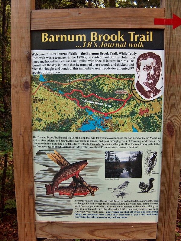
While Teddy Roosevelt was a teenager in the 1870's, he visited Paul Smiths Hotel four times and honed his skills as a naturalist, with special interest in birds. His Journals of the day . . . — — Map (db m174919) HM
On Bloomingdale Avenue (New York State Route 3) at Depot Street, on the right when traveling west on Bloomingdale Avenue.
Saranac Lake has been the “Gateway to the Wilderness” since the 1850s. With the arrival of the railroad came an eclectic assortment of travelers who made history in Saranac Lake. The early 1900s saw Saranac Lake become a fashionable . . . — — Map (db m147496) HM
Medals of Honor
Dedicated to those who gave above and beyond
the call of duty for their country
U.S.A.
Lang, George C. • Roosevelt, Theodore • Roosevelt, Theodore Jr. • Shea, Charles W. • Valente, Michael • Karopczyc, Stephen Jr. . . . — — Map (db m106304) WM
Near Sagamore Hill Road, on the right when traveling north.
In Theodore Roosevelt’s time this field was a three-acre garden of vegetables, fruit trees, and berries. It produced potatoes, lima beans, lettuce, and carrots, peach, plum, and pear trees, and multiple grape arbors. Despite its size the garden was . . . — — Map (db m90372) HM
Near Sagamore Hill Road, on the right when traveling north.
This land around you had always been a working farm. When Theodore Roosevelt bought the property in 1880 it already included an orchard, fields of corn, asparagus, and buckwheat as well as an old barn. After the purchase, Roosevelt had his own . . . — — Map (db m90406) HM
Near Sagamore Hill Road, on the right when traveling north.
It was on this piazza that Teddy Roosevelt was notified of his nomination for Governor of New York in 1898, for Vice President in 1900, and for President in 1904. He had the railing removed here to address more effectively groups gathered on the . . . — — Map (db m42967) HM
Near Sagamore Hill Road, on the right when traveling north.
Six Roosevelt children and nearly a dozen neighboring cousins could be a rambunctious group. Sometimes Edith Roosevelt needed a place for solitude. The Arbor was not too far from the house. She could enjoy the sun and scented roses, yet still be . . . — — Map (db m90399) HM
Near Sagamore Hill Road, on the right when traveling north.
The windmill to your left is a re-creation of two previous windmills Theodore Roosevelt had built. The first was constructed when the house was built. A second windmill, and a supplemental gas-powered pump, replaced that one in 1905. The mills . . . — — Map (db m90398) HM
Near Sagamore Hill Road, on the right when traveling north.
Theodore Roosevelt’s new home crowned a treeless hill that sloped down to the water on three sides. Across their lawn the family could watch ferryboats plying Long Island Sound. Roosevelt planted shade trees around the home, but cut down other trees . . . — — Map (db m43031) HM
On Shore Avenue at Audrey Avenue, on the right when traveling west on Shore Avenue.
The Hamlet changed drastically and quickly in the early 20th century, but things began to slow after Theodore Roosevelt’s presidency came to an end in 1909. His impact, however, would continue to shape Oyster Bay for years to come, even after his . . . — — Map (db m90409) HM
Near Sagamore Hill Road, on the right when traveling north.
Mealtimes were family times for the Roosevelt family. Breakfast might include peaches and cream, fried liver and bacon, grits, waffles, cereal, milk, and for Theodore Roosevelt, lots of coffee. Dinners often featured fried chicken covered with . . . — — Map (db m90369) HM
Near Sagamore Hill Road, on the right when traveling north.
Sagamore Hill may have been a working farm, but it was also a playground for Theodore Roosevelt. He cleared much of the land, but left these 35 acres as woodlands filled with chestnuts, elms, and cedars. It was home to wildlife and allowed . . . — — Map (db m90336) HM
Near Sagamore Hill Road, on the right when traveling north.
For 50 years, the look of Sagamore Hill changed little. Then in 1938, Theodore Roosevelt, Jr., the President’s eldest son, built this Georgian home here on four acres of the farm’s old apple orchard. The house is now open to visitors as a museum of . . . — — Map (db m42965) HM
On Sagamore Hill Road, on the right when traveling north.
In Roosevelt’s day, fields of timothy and corn ran downhill from here to an early 19th-century hay barn – the scene of childhood games. You could look left across a quarter mile of pasture to the old apple orchard and the woods. The crack of . . . — — Map (db m43053) HM
Home train station of Theodore Roosevelt President of the United States 1901 - 1909, July 2005 Placed on the National Register of Historic Places. Plaque sponsored by the Theodore Roosevelt Association and Oyster Bay Historical Society — — Map (db m62060) HM
On South Street (County Route 106) at Lexington Avenue / Berry Hill Road, on the left when traveling south on South Street.
To the memory of those from Oyster Bay who gave their lives in the service of their country in the World War 1917 – 1918 --------------- Let those who come after see that these men shall not be forgotten. Nicolas Abbati Frank Boday Fred H. . . . — — Map (db m42854) HM
On E Main Street near Church Street, on the right when traveling east.
Completed 1873, stick-style architecture. Boyhood church of Theodore Roosevelt, 26th President. Listed on National Register of Historic Places.
J. Cleveland Cady, Architect — — Map (db m42806) HM
Near Sagamore Hill Road, on the right when traveling east.
This stone is from the grave of Quentin Roosevelt Youngest son of Theodore and Edith Kermit Roosevelt who was killed in aerial combat in France on July 14, 1918 and was buried where he fell near Chamery. His body was moved in 1955 to the Normandy . . . — — Map (db m7974) HM
Near Railroad Avenue, on the left when traveling east.
To the sacred memory of Theodore Roosevelt The Great American President of the United States 1901 – 1908 Planted Palm Sunday 1919 A.D. by Paul Brorstrom — — Map (db m53687) HM
On Railroad Avenue, on the left when traveling east.
The Book of Theodore Roosevelt’s Life Written in Rocks Chapter 1 – Born Oct 27, 1858. Brick from 28 E 20 NYC where Roosevelt was born. Presented by Women’s Roosevelt Memorial Assn. Chapter 2 – Regaining his Health. Granite step from . . . — — Map (db m53686) HM
On Sagamore Hill Road, on the right when traveling north.
Tennis at Sagamore Hill had unique challenges and court rules. The ground wasn’t level and tree branches closed in the court. The Roosevelts allowed “that when a ball hit a branch and might have gone in it was a ‘let.’” For Theodore . . . — — Map (db m90338) HM
On Sagamore Hill Road, on the right when traveling north.
“The house stands right on the top of the hill, separated by fields and belts of woodland from all other houses, and looks out over the bay and the Sound. We see the sun go down beyond long reaches of land and water . . . We love all the . . . — — Map (db m42838) HM
Near Sagamore Hill Road, on the right when traveling north.
Sagamore Hill was the family home of our 26th President Theodore Roosevelt, his wife Edith and their six children. He built the Queen Anne Shingle style home on 155 acres between 1884 and 1886 and it became known as the “Summer White House” during . . . — — Map (db m42840) HM
Near Sagamore Hill Road, on the right when traveling north.
Sagamore Hill had been farmland before Theodore Roosevelt bought the property. He intended to live here and keep it a working farm. The farm would need animals and farm workers; both would need shelter. The first building Roosevelt had built . . . — — Map (db m90375) HM
Near Cove Road at Cove Neck Road, on the right when traveling east.
From this spot the cortege proceeded up the steps on your left to his final resting place on the hill overlooking the bay. “In the long fight for righteousness the watchword for all of us is spend and be spent.” . . . — — Map (db m42842) HM
Near Sagamore Hill Road, on the right when traveling east.
In honored memory of Theodore Roosevelt Scout Commissioner 1917-1919 Nassau County Council Boy Scouts of America Dedicated by The Scouts of Nassau County June 14, 1953 — — Map (db m42871) HM
On Audrey Avenue at Shore Avenue, on the left when traveling south on Audrey Avenue.
Citizen of Oyster Bay President of the United States * * * * * * * * * * “The way to be good citizens of this nation is to be good citizens of Oyster Bay” * July 4, 1906 * — — Map (db m65120) HM
On Railroad Avenue, on the left when traveling east.
This park, the gift of a grateful people is dedicated to the memory of Theodore Roosevelt twenty-sixth President of the United States Born New York City 1858 – Died Oyster Bay 1919 “We here in America hold in our hands the hope of . . . — — Map (db m53688) HM
On West End Avenue at Larrabee Avenue, on the left when traveling north on West End Avenue.
This park, the gift of a grateful people is dedicated to the memory of Theodore Roosevelt twenty-sixth President of the United States Born New York City 1858 – Died Oyster Bay 1919 “We here in America hold in our hands the hope of . . . — — Map (db m53689) HM
On South Street (County Route 106) at Lexington Avenue / Berry Hill Road, on the left when traveling south on South Street.
Cast from the original 1922 mold Created by sculptor Alexander Phimister Proctor 1860 – 1950 Dedicated October 29, 2005 as the Centennial Project of the Rotary Club of Oyster Bay Re-dedicated on this site by the T.R. Statue Fund October 30, . . . — — Map (db m42867) HM
On Sagamore Hill Road, on the right when traveling north.
While most families have a pet or two, the Roosevelt family nearly had a zoo. At various times they had dogs, cats, horses, guinea pigs, snakes, flying squirrels, kangaroo rats, birds, a bear cub, and a badger. The death of a pet meant a funeral . . . — — Map (db m90403) HM
On School Street at Jefferson Street, on the right when traveling north on School Street.
Children's Library
Robert Bacon Memorial
1924
One of the first libraries in the world
specifically dedicated as a children's library.
The building and art were privately endowed by
Martha Bacon in memory of her husband
Colonel Robert . . . — — Map (db m133532) HM
Near State Street south of Battery Place, on the right when traveling south.
Edison's Laboratory and Home
West Orange, New Jersey
This site features Thomas A. Edison's home, laboratories, and library. Edison developed the practical phonograph and the movie camera here.
Eleanor Roosevelt's . . . — — Map (db m207517) HM
On Cooper Square at East 8th Street, on the right when traveling north on Cooper Square.
The Cooper Union for the Advancement of Science and Art is America’s first free college. Founded by progressive thinker/abolitionist/inventor Peter Cooper, its doors were opened to all, regardless of race, religion, gender or social status.
Its . . . — — Map (db m136713) HM
On East 20th Street, on the right when traveling east.
Theodore Roosevelt was born here October 27, 1858 Birthplace reproduced by the Womans Roosevelt Memorial Association January 6, 1921 — — Map (db m146245) HM
On East 20th Street east of Broadway, on the right when traveling east.
President Theodore Roosevelt was born here on October 27, 1858, and lived here until he was 15. The house, a typical brownstone of the 1840s, was restored in 1923 and opened as a museum. — — Map (db m146246) HM
On Second Avenue south of East 20th Street, on the right when traveling north.
Augustus Saint-Gaudens was a sculptor born on March 1, 1848 in Dublin. Ireland was in the grip of the Great Potato Famine, and his family immigrated to New York, taking 6-month-old Augustus with them.
Saint-Gaudens’ father, Bernard, was a . . . — — Map (db m151069) HM
On Second Avenue south of East 20th Street, on the left when traveling south.
Augustus Saint-Gaudens (1848-1907) was the preeminent sculptor of the Gilded Age of American art. He not only created some of the country’s finest landmarks but also helped to foster arts education and the collaboration between artists that . . . — — Map (db m150948) HM
On Irving Place, on the right when traveling north.
Secretary of State in the Cabinet of
President Theodore Roosevelt, 1905-09
Secretary of War, 1899-1904
Senator from New York, 1909-1915
Lived in a house on this site from 1871 to 1878 — — Map (db m47296) HM
On Bowery at Broome Street, on the right when traveling south on Bowery.
Though it has undergone several renovations and name changes over the years, this is believed to be the oldest continuously operating hotel in New York City, welcoming guests since at least 1835.
According to the classic book, Old Bowery . . . — — Map (db m132652) HM
On Bowery near Prince Street, on the right when traveling south.
A designated New York City landmark, this Queen Anne-style building opened on October 15, 1885 as the Young Men’s Institute, a branch of the YMCA. Featuring a gymnasium, bowling alley, library, entertainment hall, and rooftop garden, the Institute . . . — — Map (db m133401) HM
On Kenmare Street near Cleveland Place, on the right when traveling west.
Left marker:
Joseph (Giuseppe) Petrosino (1860-1909) was the first Italian-American lieutenant and detective in the New York City Police Department. Petrosino formed the “Italian Branch”, an elite corps of Italian-American . . . — — Map (db m133619) HM
On Kenmare Street at Cleveland Place, on the right when traveling north on Kenmare Street. Reported permanently removed.
This small park is at the crossroads of several dynamic New York neighborhoods: Little Italy and the Bowery to the east, Chinatown to the south, and SoHo to the west and north. The site/area became parkland as a result of the City Charter of 1938, . . . — — Map (db m133620) HM
On Central Park West near 79th Street, on the right when traveling south.
This statue was unveiled to the public in 1940, as part of a larger New York State memorial to former N.Y. governor and U.S. President Theodore Roosevelt. Today, some see the statue as a heroic group; others, as a symbol of racial hierarchy. . . . — — Map (db m142889) HM
On West 81st Street east of Columbus Avenue, on the left when traveling west.
This Upper West Side park, home to the American Museum of Natural History, honors New York City Police Commissioner, Governor of New York State, Vice-President, and (following William McKinley's assassination) the youngest man to serve as . . . — — Map (db m226313) HM
On Morningside Avenue at Dr. Martin Luther King Jr. Boulevard, on the right when traveling south on Morningside Avenue.
Acquired and dedicated in 1941, this park is named for Franklin Delano Roosevelt (1882-1945), the 32nd President of the United States, who led the country through the Great Depression and World War II. Like his distant cousin Theodore Roosevelt . . . — — Map (db m241510) HM
On Washington Place west of 6th Avenue, on the left when traveling east.
The poet lived here at intervals from 1909 - 1912, while writing "The Town Down the River," a collection of poems including "Miniver Cheevy," dedicated to President Theodore Roosevelt, an admirer and supporter of Robinson. — — Map (db m98821) HM
In 1903, the people of New York voted to build the Barge Canal System. The new canal, unlike the old, utilized canalized natural water courses as well as artificial channels. The new concrete locks (57 in all) were electrically operated and could . . . — — Map (db m76934) HM
Constitution Island was purchased by Henry Whiting Warner, an attorney from New York City, who became interested in the island while visiting his brother, Thomas, who served as the Chaplain at West Point from 1823 until 1838. A thick stone . . . — — Map (db m89119) HM
On Northern Boulevard (New York State Route 25A) just east of Linden Place, on the right when traveling west.
This striking Romanesque Revival structure was built in 1862, and served as Flushing's town hall until 1898, when the Village of Flushing was incorporated into New York City.
For many years Town Hall was at the center of Flushing's social, . . . — — Map (db m193413) HM
On 118th Street just south of 85th Avenue, on the right when traveling north.
This religious organization was the first established in Richmond Hill in 1869. In 1874 a wooden Gothic Revival building designed by Henry Dudley was erected here on land donated by Albon Platt Man, the founder of Richmond Hill. The first rector was . . . — — Map (db m242739) HM
Noted naturalist-taxidermist John Graham Bell (1812-89) and his wife, Ann Briggs Bell (1820-94), lived here. Mr. Bell was a pioneer in taxidermy and friend and associate of leading naturalists and ornithologists of his day. In 1843 he traveled with . . . — — Map (db m122290) HM
It Began with a Boom Just over a century ago, more than a thousand cubic yards of the Palisades Cliffs were being blasted away every day for a growing New York in need of roads and foundations. The constant explosions could be felt and heard . . . — — Map (db m44589) HM
It Began with a Boom Just over a century ago, more than a thousand cubic yards of the Palisades Cliffs were being blasted away every day for a growing New York in need of roads and foundations. The constant explosions could be felt and heard . . . — — Map (db m53741) HM
The foundation at which you are now standing was probably built in the 1790's as the basis for a mansion owned by Henry Walton. We
have no pictures of the original building but can assume it looked somewhat like this picture from the late 1800's. . . . — — Map (db m134003) HM
By the 20th century, Saratoga's waters were celebrated throughout the nation. Tourists to Saratoga and the public at large were pursuing a healthy lifestyle that included a proper diet and exercise. Even Theodore Roosevelt was an ardent promoter . . . — — Map (db m130056) HM
On Main Street (County Route 77) at Ski Bowl Road, on the right when traveling north on Main Street.
Side One
Johnsburg
Rivers, Rails, Teddy, Treasures and Trails
Johnsburg lies at the heart of the
Adirondacks, where the rails came
to an end over a century ago. Teddy
Roosevelt rode through the wilderness to catch a train when . . . — — Map (db m147364) HM
The North Creek Railroad Station, the northernmost terminus of the Adirondack Railroad, is listed on the State and National Historic Registers as a fine example of a 19th Century rural station. The depot itself was built in 1871, and remains . . . — — Map (db m138521) HM
On Railroad Place, on the right when traveling west.
At this site early in the morning of September 14, 1901 Theodore Roosevelt received the message that President McKinley had died in Buffalo and that he had become President of the United States. — — Map (db m22535) HM
Near Railroad Place, on the right when traveling north.
Family Man
Roosevelt said his father was the greatest man he ever knew, and he was instrumental in building up young "Teedie" from a sickly child into the robust man. Roosevelt's devotion to his family was a sustaining force throughout his . . . — — Map (db m41402) HM
On Railroad PLace, 0.1 miles east of Main Street, on the left when traveling east.
While visiting the Pan-American Exposition in Buffalo on September 6, 1901, President McKinley was shot and wounded in an assassination attempt. Vice President Theodore Roosevelt arrived in western New York the next day. Four days later, with . . . — — Map (db m138517) HM
On Railroad Place, 0.1 miles east of Main Street, on the left when traveling east.
Citizen Soldier
“I waved my hat and went up the hill with a rush.” In 1898, Roosevelt resigned as Assistant Secretary of the Navy, volunteered for service in the Spanish-American War and became Lieutenant Colonel of the 1st United . . . — — Map (db m138518) HM
On State Highway 12, 4 miles south of Lifeboat Station Road, on the left when traveling south.
Panel 1
Welcome & Enjoy
Your National Wildlife Refuge
Pea Island
Established in 1938, Pea Island NWR included over 5,800 acres of typical barrier island habitat that has been carefully managed to better provide for the needs . . . — — Map (db m76739) HM
Near West Trade Street at South Polar Street. Reported missing.
Mary Anna Morrison Jackson, Mecklenburg native and widow of Confederate General T.J. "Stonewall" Jackson, lived many years on this site. Her home was a mecca for Confederate soldiers and dignitaries including Presidents Theodore Roosevelt and . . . — — Map (db m92880) HM
On 3rd Avenue at Main Street, on the right when traveling east on 3rd Avenue.
The American cowboy has become a mythical figure in the national consciousness. This would, no doubt, have surprised most of the common laborers who earned meager pay as cowboys. A number of them were indeed colorful characters. Some became outlaws . . . — — Map (db m88061) HM
On Pacific Avenue at 3rd Street, on the right when traveling east on Pacific Avenue.
The Little Missouri Badlands have always been ideal habitat for wildlife. American Indians hunted these lands for centuries. The first known white explorers, the La Verendrye brothers, ventured into the badlands in 1742. Trapper Jean Baptiste La . . . — — Map (db m87992) HM
On Easy River Road, on the left when traveling north.
Behind the visitor center is an old, rustic cabin. Architecturally insignificant, a person might wonder why it is here. To understand, step over the threshold and walk inside the building that housed a future president at a pivotal moment in . . . — — Map (db m87230) HM
On Main Street north of 3rd Avenue, on the right when traveling north.
Joe Ferris wore many hats in Medora. He was a hunting guide, a Medora postmaster and a successful merchant. Ferris opened his first general store in Little Missouri. In 1885 he began work in Medora on the current two-story, 25-foot by 75-foot . . . — — Map (db m88062) HM
On Pacific Avenue, on the right when traveling west.
The town of Little Missouri was founded in 1880 at the site of the Northern Pacific Railroad section house and depot, on the west bank of the river. In late 1880, Frank Moore, the Post Trader of the nearby military cantonment, opened the Pyramid . . . — — Map (db m87982) HM
On Broadway at 3rd Street, on the right when traveling east on Broadway.
Margaret Barr was born in Ireland on September 15, 1853, and immigrated to Iowa with her family about 1864. In April 1871, she married John Lloyd Roberts from Wales, and soon became a pioneer wife to a cattle dealer and butcher. The couple arrived . . . — — Map (db m88018) HM
On Pacific Avenue at 3rd Street, on the right when traveling east on Pacific Avenue.
The railroad reached the Little Missouri River in 1880. The Northern Pacific Railroad named the stop Pyramid Park. When the Marquis de Mores and Theodore Roosevelt arrived in 1883, the train depot was on the west side of the Little Missouri River. . . . — — Map (db m87986) HM
On 3rd Avenue near 3rd Street, on the right when traveling west.
George Fitzgerald’s success operating the Hotel de Mores was such that in November 1884 he began work on his own 35-feet by 80 feet two-story hotel. Brick veneer was planned but was never added. The Bad Lands Cow Boy described its interior . . . — — Map (db m87499) HM
On Main Street at 3rd Avenue, on the left when traveling north on Main Street.
At the age of 22, Arthur T. Packard started Medora’s first newspaper, The Bad Lands Cow Boy. The first issue came off the press on February 7, 1884. Marquis de Mores was the major advertiser in the paper. Editor Packard produced a paper . . . — — Map (db m88045) HM
On Broadway at 3rd Street, on the right when traveling west on Broadway.
Theodore Roosevelt first came to the badlands in September 1883 to hunt buffalo. “Old Four Eyes” loved the life of the badlands’ cowboys and participated in roundups, brandings and social events, earning the respect of those he so . . . — — Map (db m88009) HM
In the spring of 1886 thieves stole Theodore Roosevelt’s boat from his Elkhorn Ranch, 25 miles south of here. Roosevelt pursued the thieves past this point and captured them at the mouth of Cherry Creek about 24 miles downstream. He then . . . — — Map (db m87201) HM
Near Interstate I-94, on the right when traveling west.
Theodore Roosevelt, 24 years old, came to the North Dakota badlands from New York City to hunt his first buffalo. For a week there was nothing but rain – at last some fresh tracks. And after hard riding, and a lot of missed shots, Roosevelt . . . — — Map (db m87203) HM
Near Interstate 94, on the right when traveling west.
The National Park Service and its neighbors wage a costly campaign to contain the spread of noxious weeds by fighting back on several fronts. Mowing, prescribed fires, spraying chemicals, and new insect allies – all contribute to restore the . . . — — Map (db m88607) HM
Near Interstate 94, on the right when traveling west.
Painted Canyon . . . the name itself evokes an image of color and light playing across the face of a wild and broken land. Of the countless individuals who have stood transfixed at the canyon rim – Native Americans, fur traders, a cavalry . . . — — Map (db m87204) HM
On 3rd Street East just east of Sims Street, on the left when traveling east.
Theodore Roosevelt was 27 years old when he delivered his famous Independence Day speech in Dickinson in 1886. The New York assemblyman, writer, and informer first came to the Dakota Badlands in September 1883 to kill a bison. He got his buffalo . . . — — Map (db m238081) HM
On 3rd Street East just east of Sims Street, on the left when traveling east.
In April 1886 Roosevelt tracked down three desperadoes who had stolen his boat from the Elkhorn Ranch and marched them to justice in Dickinson. It was one of the greatest adventures of his life. His feet were so battered from his long overland trek . . . — — Map (db m238082) HM
On 3rd Street East just east of Sims Street, on the left when traveling east.
In July of 1886, a young Theodore Roosevelt gave his first major public speech right here in Dickinson, North Dakota. Roosevelt had been asked to give the Independence Day speech by Dr. Victor Stickney, the man who had patched up Roosevelt's feet . . . — — Map (db m238083) HM
Near East Burdick Expressway (Business U.S. 2) at 13th Street Southeast, on the right when traveling west.
Medal of Honor Citation Lt. Col. Roosevelt distinguished himself by acts of bravery on July 1, 1898 near Santiago de Cuba, Republic of Cuba, while leading a charge, accompanied by only four or five men up San Juan Hill. This action encouraged . . . — — Map (db m231684) HM
Susan Brownell Anthony
Woman Suffrage Leader
Visited October 19, 1878
"To secure both national and 'domestic tranquility,' to 'establish justice,' to carry out the spirit of our Constitution, put into the hands of all women....the . . . — — Map (db m53838) HM
On Belmont Street, 0.1 miles north of 34th Street, on the right when traveling south.
Side 1
Union Square and Its Uses
Labeled "Union Square" on the first village maps, block 12 of the City of Bellaire was formed by joining portions of the Harris and Rodefer Farms in 1857. Used for tent shows, circuses, political . . . — — Map (db m78494) HM
On East Mansfield Street (U.S. 30) at Penn Avenue, on the right when traveling west on East Mansfield Street.
This monument, erected by lodge members and friends, is affectionately dedicated
to the memory of John Edward Hopley, 1850 - 1927, pioneer in Lincoln Highway development. First state consul for Ohio of the Lincoln Highway Association. In 1887 he . . . — — Map (db m135375) HM
On Detroit Road (Ohio Route 254) just west of Walden Drive, on the right when traveling west.
Born in Jefferson, Ohio, Theodore E. Burton graduated from Oberlin
College and became a prominent Cleveland attorney. He was elected
to Congress in 1888 and served from 1889-91, 1895-1909, and
1921-28. He was elected U.S. Senator in 1908 and . . . — — Map (db m134265) HM
University Hall was completed in 1893. It is constructed of Amherst Sandstone. The bell tower rises to a height of 148 feet. The structure houses administrative offices, classrooms, and the legendary Gray Chapel. Among the celebrities who have . . . — — Map (db m12845) HM
Near High Street south of Broad Street (U.S. 40), on the right.
This tree (a Scarlett Oak) was placed here by the Roosevelt National Living Memorial Association, as a living tribute to the great lover and defender of Country and Flag, and our youngest President of the United States—Theodore Roosevelt.
. . . — — Map (db m9866) HM
On Auburn Avenue, on the left when traveling south.
William Howard Taft. Born here on September 15, 1857, William Howard Taft is the only American to have served as President and Chief Justice of the United States. His unique career of public service began after he graduated from Yale . . . — — Map (db m168978) HM
Piqua's public square, like in many mid-western communities, functions as the historical and cultural center of the city. Long after government buildings have moved to newer and larger sites, the public square maintains its status as the focal . . . — — Map (db m17367) HM
Near Route 125, 0.7 miles north of Mackletree Road, on the left when traveling north.
In the early 20th century Ohio’s deer, wild turkey, beaver, bobcat, and other wildlife populations were facing extinction due to the widespread loss of forests combined with uncontrolled hunting. Ohio’s first wildlife area, The Theodore Roosevelt . . . — — Map (db m225778) HM
On Main Street (Ohio Route 29/47), on the left when traveling north.
Theodore Roosevelt
Former President Theodore Roosevelt addressed a large crowd from these steps on May 16, 1912. He was introduced by C. B. De Weese.
William Howard Taft
President William Howard Taft was the first sitting . . . — — Map (db m28619) HM