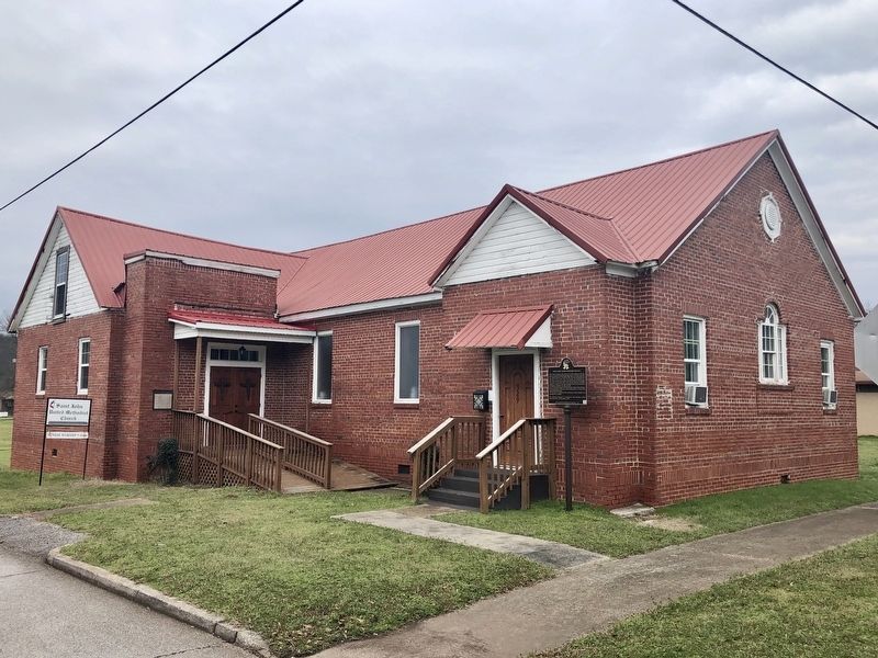
On East D Street at South Christine Avenue, on the left when traveling east on East D Street.
Saint John, founded at the turn of the 19th century, is the first
African-American Methodist Episcopal Church in South Anniston.
The original structure was built in 1922. The current building was
erected in 1951 on the corner of D Street and . . . — — Map (db m144905) HM
On Quintard Avenue (U.S. 431) at East 18th Street, on the right when traveling south on Quintard Avenue.
Built by John Ward Noble, one of Anniston’s founders. Consecrated on September 29, 1890. Widely acclaimed for unique and beautiful Norman Gothic architecture. The church dominated by imposing 95 foot bell tower.
Open Daily — — Map (db m36540) HM
On West 17th Street at Cooper Avenue, on the right when traveling west on West 17th Street.
Seventeenth Street Missionary Baptist Church served as the home of "mass meetings" for black Annistonians who planned and executed Anniston's part of the Civil Rights Movement. Reverends D.C. Washington (1937-1960) and Nimrod Q. Reynolds . . . — — Map (db m106651) HM
On West 4th Street east of Spruce Avenue, on the right when traveling east.
Local "Jim Crow" laws in the first half of the 20th century enforced racial segregation in public transportation facilities throughout the South. The U.S. Supreme Court decision in Boynton v. Virginia (1960) upheld that segregation in these . . . — — Map (db m106602) HM
On Gurnee Avenue south of 12th Street, on the right when traveling south.
In 1917, Block 148 appeared much as it did thirty years earlier. The only new addition was the Chero-Cola Bottling Company on West 12th Street. However, the surrounding blocks, which had been residential or had remained undeveloped, saw some major . . . — — Map (db m217673) HM
On Quintard Avenue (U.S. 431) at East 13th Street, on the right when traveling north on Quintard Avenue.
Temple Beth El is the oldest building continuously used for Jewish worship in Alabama. Anniston’s Reform Jewish congregation was established in 1888. Its women’s organization, the Ladies Hebrew Benevolent Society, directed the construction of the . . . — — Map (db m36543) HM
In April 1888, the founder of a newly established Reform Jewish congregation purchased twenty-three lots in Hillside Cemetery to bury their deceased members.
In 1987, the City of Anniston vacated right-of-way that allowed the Temple to expand the . . . — — Map (db m53163) HM
Near Gurnee Avenue south of West 11th Street, on the left when traveling south.
The Ambush: 12:54 p.m. - 1:10 p.m.
The silence didn't last long. Anniston Klansman William Chappell and a screaming mob of about 50 white men surrounded the bus. An 18-year-old Klansman, Roger Couch, lay on the pavement in front of the bus to . . . — — Map (db m217413) HM
On Choctaw Street north of Tomahawk Trail, on the right when traveling north.
Major John Pelham C.S.A.
Born September 14, 1838
at the home of his Grand Parents
William McGehee and Elizabeth Clay McGehee
Erected by Forney District U.D.C.
May 5, 1937 — — Map (db m36547) HM
Near Gurnee Avenue south of West 11th Street, on the left when traveling south.
While the Riders awaited rescue, the bus continued to burn. The Anniston Fire Department extinguished the flames and administered oxygen. A state trooper called an ambulance, but it took Cowling to force the driver to carry the injured black Riders . . . — — Map (db m217419) HM
Near Gurnee Avenue south of West 11th Street, on the left when traveling south.
The Rides began in May 1961 when the Congress of Racial Equality (CORE) decided to test a 1960 U. S. Supreme Court ruling that outlawed segregation in depot restaurants and restrooms serving interstate passengers.
Previously, CORE had organized a . . . — — Map (db m217406) HM
On Gurnee Avenue south of 12th Street, on the right when traveling south.
The Anniston City Commission, on May 16, 1963, established by resolution the Human Relations Council, consisting of five white men and four black men. The Council's purpose was to "make recommendations concerning human relations," and its members . . . — — Map (db m106627) HM
On Quintard Avenue at East 17th Street, on the right when traveling north on Quintard Avenue.
The Legacy of the Military
On the other side of Anniston, the Army constructed an Ordnance Depot on 15,000 acres west of the city during WWII. Over time, the depot evolved into the region's largest employer. The economic and community . . . — — Map (db m106619) HM
On West 11th Street at Gurnee Avenue, on the right when traveling west on West 11th Street.
Willie Brewster became the target of white extremists after words spoken at a National States Rights Party encouraged them to commit acts of violence against blacks. As Brewster drove home with co-workers from the night shift at Union Foundry, he . . . — — Map (db m106626) HM
Near Gurnee Avenue south of West 11th Street, on the left when traveling south.
The most famous photograph of the Freedom Rides and one of the most iconic of the Civil Rights movement was taken by a freelance photographer for The Anniston Star. Joe Postiglione, called “Little Joe” by his friends, was tipped off by the Greyhound . . . — — Map (db m217422) HM
Near Gurnee Avenue south of West 11th Street, on the left when traveling south.
The Alabama Knights of the Ku Klux Klan had known about the Freedom Ride since mid-April and had detailed information on the city-by-city itinerary, thanks to FBI memos forwarded to the Birmingham Police Department. In a series of secret meetings in . . . — — Map (db m217411) HM
Near Gurnee Avenue south of West 11th Street, on the left when traveling south.
CORE leadership solicited applicants for the Ride from outside the organization as well as CORE veterans. They tried to achieve a reasonably balanced mixture of black and white, young and old, religious and secular. The only deliberate imbalance was . . . — — Map (db m217410) HM
On Noble Street at East 9th Street, on the right when traveling north on Noble Street.
1st Panel
Two busloads of Freedom Riders arrived in Alabama on Sunday, May 14, 1961, bound for New Orleans. It was an organized effort by the Congress of Racial Equality (CORE) to challenge the South's continued defiance of U. S. . . . — — Map (db m106721) HM
On Noble Street at 9th Street, on the right when traveling north on Noble Street.
Throughout the first half of the 20th century, race relations in the South were dominated by local "Jim Crow" laws. Although in 1960 the Supreme Court ruled that racial segregation violated the Interstate Commerce Act, local laws persisted. . . . — — Map (db m106605) HM
Near Gurnee Avenue south of West 11th Street, on the left when traveling south.
But the Ride didn't end. The national newspaper and television coverage of what had happened galvanized the Nashville Student Movement, which already had experience successfully challenging segregationist practices through lunch counter sit-ins, . . . — — Map (db m217421) HM
On East 10th Street at Quintard Avenue, on the right when traveling west on East 10th Street.
In 1904, 18 year old Tyrus Raymond Cobb lived in a boarding house on this site while playing minor league baseball for the Anniston Steelers. From nearby Scarbrough Drug Store on Noble Street he wrote letters, using fictitious names, to sports . . . — — Map (db m106606) HM
On Noble Street at East 12th Street, on the right when traveling north on Noble Street.
This property
has been placed on the
National Register
of Historic Places
by the United States
Department of the Interior
United States Federal Building - Courthouse
Built 1906 — — Map (db m217266) HM
On West 15th Street west of Walnut Avenue, on the right when traveling west.
This district was once the economic and social hub of Anniston's African American community. In its heyday (1940-1950), the District was a "city within a city," with businesses that catered to the black community. Grocery stores, restaurants, . . . — — Map (db m106650) HM
Near Gurnee Avenue south of West 11th Street, on the left when traveling south.
In Atlanta, the Riders separated into two integrated groups to board two different buses; the seven who were on the Greyhound bus destined for Anniston included:
• Albert Bigelow, 55 white male from Connecticut (a retired naval officer, . . . — — Map (db m217409) HM
On Martin Luther King Drive east of Douglas Street, on the right when traveling east.
Front
Hobson City is Alabama's first incorporated black city. The area was first known as Mooree Quarter, a black settlement that was part of Oxford, Alabama. After a black man was elected Justice of the Peace in Oxford, one mayor . . . — — Map (db m106598) HM
On Pelham Road (Alabama Route 21) at 5th Street NE, on the right when traveling north on Pelham Road.
Dean of American College Presidents
President of Jacksonville State Normal-State Teachers College 1899-1942
During an Educational Renascence in the South he was in the forefront of the Alabama Educational System
President 1st National Bank . . . — — Map (db m29922) HM
On Public Square West (State Highway 21) south of Clinton Street Southwest, on the left when traveling south.
This regiment took part for four years in major battles of Virginia theater. It served with distinction for dash and courage, suffering heavy casualties.
Officers at regiment’s organization June 4, 1861 at Montgomery, Alabama;
Colonel John . . . — — Map (db m36465) HM
On Pelham Road (State Highway 21) at James Street SE, on the left when traveling north on Pelham Road.
This house, "Ten Oaks", was headquarters for Gen. P.G.T. Beauregard, Oct. 15-23, 1864, when he coordinated the movement of Gen. J.B. Hood's army, then marching across northeast Alabama enroute to Nashville. He and his retinue, including Gov. I.G. . . . — — Map (db m29919) HM
Near Mountain Street Northwest west of Woodward Avenue Northwest.
The Chief Ladiga Trail was named for a Creek Indian leader who signed the Cusseta Treaty in 1832. Under the terms of that agreement, the Creeks gave up claim to their remaining lands in northeast Alabama. Because he had signed the treaty, Ladiga was . . . — — Map (db m36438) HM
On Clinton Street Southeast, on the right when traveling west.
This Church was used for a
Confederate Hospital
During the War
Between The States
Erected by
General John H. Forney
Chapter U.D.C. Sept 27, 1937 — — Map (db m36539) HM
On Gayle Avenue SW at Clinton Street SW, on the left when traveling north on Gayle Avenue SW.
This general practitioner's office is the only remaining structure of its type in northeast Alabama. It was built on the court-house square about 1850 by Dr. J. C. Francis, a beloved family doctor who served Jacksonville for more than 50 years. He . . . — — Map (db m23350) HM
On Public Square East (State Highway 21) north of Ladiga Street Southeast, on the left when traveling north.
Selected as a landmark contributing to a deeper
understanding of our American Heritage.
Entered on
The National Register of Historic Places
by the
United States Department of the Interior
May 13, 1986
Centered around Jacksonville’s . . . — — Map (db m36479) HM
On Public Square West (State Highway 21) south of Clinton Street Southwest, on the left when traveling south.
Jacob Forney III lived and operated a thriving mercantile establishment at Jacksonville from 1835-56 on the south-east corner of the square. He and his wife Sabina Swope Hoke were the parents of nine children.
1. Daniel Peter - b. Feb. 24, 1819, . . . — — Map (db m36450) HM
On Ladiga Street Southeast, on the right when traveling east.
From 1836 to 1881 the head of the City Government
carried the title of Intendant. After that
that the office has been filled by the Mayor.
The following have served in this capacity:
William Harrison Fleming,
1836-49, 1859-61
John D. Hoke, . . . — — Map (db m36533) HM
On Pelham Road North (State Highway 21) at Mountain Street Northeast, on the right when traveling north on Pelham Road North.
Postoffice established July 20, 1833 as Drayton, Benton County, Alabama. Name changed to Jacksonville Aug. 6, 1834 and county changed to Calhoun Jan. 29, 1858. Office maintained by Confederate Government 1861-1865.
Postmasters and dates of . . . — — Map (db m36449) HM
On Public Square East (State Highway 21) west of Ladiga Street Southeast, on the left when traveling north.
Town first called Drayton.
Renamed in 1834 to honor
President Andrew Jackson.
Seat moved to Anniston in 1899.
Calhoun Co. originally was Benton Co.,
for Col. T. H. Benton, Creek War officer,
later U. S. Senator from Missouri.
. . . — — Map (db m36471) HM
On University Circle west of North Pelham Road (State Highway 21), on the right.
This Educational Center of
Northeast Alabama Traces its Origin to
Jacksonville Male Academy 1836
Jacksonville Female Academy 1837
Calhoun College 1871
Calhoun Grange College 1878
State Normal School 1883
State Teachers College 1929
. . . — — Map (db m36426) HM
On Mountain Street Northwest west of Woodward Avenue Northwest, on the left.
Life here has long centered on education beginning in 1834 when a one-acre plot of land was reserved for a schoolhouse. Through the years, various institutions of higher learning developed that culminated into present-day Jacksonville State . . . — — Map (db m36429) HM
On Public Square West (State Highway 21) near Clinton Street Southwest, on the left when traveling south.
Graduate of West Point,
resigned from U.S. Army
to volunteer services
to State of Alabama.
Ably led Confederate forces
at Manassas, Pensacola,
Vicksburg, Mobile, Texas. — — Map (db m36482) HM
On Public Square West (State Highway 21) east of Ladiga Street Southwest, on the left when traveling south.
Lawyer, Soldier, Senator
← Lived here in 1838
1862-63 Colonel of
51st Alabama Cavalry
Raised by him in this county
1863-65 Brigadier General C.S.A.
with Wheeler’s Cavalry
1876-1907 United States Senator
Distinguished . . . — — Map (db m36468) HM
On University Circle west of North Pelham Road (State Highway 21), on the right.
Lawyer, Industrialist, Patriot
Brigadier General, U.S.A.
Gen. Burke helped rebuild
Alabama’s mining & manufacturing
interests after the Civil War.
He helped establish the Catholic
Church at Jacksonville.
His home, . . . — — Map (db m36424) HM
On Pelham Road (State Highway 21) at James Street SE, on the right when traveling north on Pelham Road.
"The Gallant Pelham" as called by Robert E. Lee Commanded Artillery, Army of Northern Virginia. Cited for conspicuous valor many times. Killed in action in Virginia. — — Map (db m29920) HM
On Church Ave SE at James St SE, on the right when traveling north on Church Ave SE.
Front:
Maj. John Pelham
born in
Alexandria, Alabama
killed at the battle of Kelly's Ford
March 17, 1863
Front base: Pelham
North side:
Erected by the General John H. Forney Chapter U.D.C. Jacksonville, . . . — — Map (db m23588) HM
On University Circle west of North Pelham Road (State Highway 21), on the right.
James G. Ryals, Jr. 1883-1885
J. Harris Chappell 1885-1886
Carleton B. Gibson 1886-1892
J. B. Jarrett 1892-1893
Jacob Forney, IV 1893-1899
Clarence William Daugette 1899-1942
Houston Cole 1942-1971
Ernest Stone 1971-1981
Theron E. . . . — — Map (db m36427) HM
On A Street Southwest near H Avenue Southwest, on the right when traveling west.
In 1905, local businessman Henry P. Ide joined with out-of-state investors and built the Ide-Profile Cotton Mill. Along with the mill, the company established the Profile Mill Village, which originally began as 40 homes for workers. The company . . . — — Map (db m195730) HM
On A Street Southwest at G Avenue Southwest, on the left when traveling west on A Street Southwest.
Profile Cotton Mills Historic District has been placed on the National Register of Historic Places in 2006 by the United States Department of the Interior — — Map (db m195728) HM
On Ladiga Street Southeast at Church Avenue Southeast, on the right when traveling east on Ladiga Street Southeast.
John D. and Anna Maria Hoke founded the parish on June 30, 1844. Members of the Hoke, Forney, and Abernathy families joined over the years. The church design was based on Richard Upjohn's 1852 pattern book, Upjohn's Rural Architecture. Upjohn was . . . — — Map (db m199134) HM
Near Mountain Street Northwest west of Woodward Avenue Northwest.
The Depot was constructed in 1860 by the Selma, Rome and Dalton (GA) Railroad. It was used as a transfer and storage point for Confederate troops and materials during the War Between the States. — — Map (db m36443) HM
On Pelham Road North at Clinton Street Southwest, on the left when traveling north on Pelham Road North.
Since 1890 the financial interests of this area have been served by The First National Bank and its predecessor The Tredagar National Bank (an institution of the "Boom" days of Jacksonville)
Organizers were Peyton Rowan, President, Jos. . . . — — Map (db m29480) HM
On Pelham Road (State Highway 21) at 5th Street NE, on the right when traveling north on Pelham Road.
Prominent citizen of Jacksonville who served Alabama as Brigadier General, State Militia; member Legislature and Pres. of Senate; Circuit Court Judge; and Pres. Ala. and Tenn. Railroad
He owned extensive cotton plantations and mining interests . . . — — Map (db m29921) HM
On Public Square East (State Highway 21) south of Clinton Street Southeast, on the left when traveling north.
Brigadier General C.S.A.
With Army of Virginia 1861-1865.
Wounded in battle five times.
He was one of four distinguished sons
of Jacob Forney and Sabina Swope Hoke
of Jacksonville who held commissions
in the Confederate Army.
. . . — — Map (db m36480) HM
On Janney Road, 0.1 miles east of Spring Road, on the left when traveling east.
The furnace was constructed by Montgomery businessman Alfred A. Janney, reportedly using slaves brought from Tennessee by a "Dr. Smith." The furnace was completed and ready to produce pig iron when, on July 14, 1864, a Union cavalry raiding force of . . . — — Map (db m25544) HM
The Archaic period covers a vast expanse of time (8,250 years).
Many changes occurred during the Archaic period. For
example, the climate and vegetation that Early Archaic people
saw was much different than the climate and vegetation that
Late . . . — — Map (db m160554) HM
In 2007, the City of Oxford began planning what is today known as
Choccolocco Park. Discoveries at the site identified the presence of the
humans inhabiting this land as early as 10,000 years ago. Oxford undertook
an archaeological investigation . . . — — Map (db m144980) HM
Boiling Springs Road once provided a vital transportation link
across Choccolocco Creek for residents of the valley. The road
received its name from the Boiling Spring (pictured below and to
the right) located across the creek at this location. . . . — — Map (db m145023) HM
Choccolocco Park is located on land that was farmed by the Caver,
Christian and Davis families from 1840 until the late twentieth
century. During the Great Depression, the farm was documented
by the Historic American Building Survey. The subjects . . . — — Map (db m145025) HM
When workers began excavating the lake for Choccolocco Park, they
uncovered several large charcoal-filled ditches that formed circles.
Archaeologists investigated these features and determined that these
were the remains of 19th century charcoal . . . — — Map (db m144947) HM
Near Recreation Drive east of Mc Cullars Lane, on the left when traveling east.
was moved on August 17 , 1990 to Oxford Lake
Leon Smith, Mayor
City of Oxford Councilmembers
Johnny Austin • Johnny Bentley • Bruce Dempsey
Norma Martin • Marshall Shaddix
The bridge was donated to the City of Oxford
by the . . . — — Map (db m198533) HM
On Main Street at Mc Kibbon Street, on the right when traveling north on Main Street.
[Top plaque]
This property has been
placed on the
National Register
of Historic Places
by the United States
Department of the Interior
[Bottom plaque]
301 Main Street
has been placed on the
Alabama Register
of . . . — — Map (db m217258) HM
On Main Street south of East Oak Street, on the right when traveling north.
A Memorial to
Gen. Andrew Jackson,
the Tennessee Patriots,
the Alabama Patriots, and
pioneers who by their
courage and fortitude in
1813 - 1814, won five successful
battles in the Creek Indian
Campaign.
Side . . . — — Map (db m106593) HM
Near Recreation Drive east of Mc Cullars Lane, on the right when traveling east.
Seaman Second Class, United States Navy, George Washington Ingram was killed in action in the defense of Pearl Harbor on December 7, 1941.
For Seaman Ingram's bravery, an American destroyer was built and named in his honor. The U.S.S. George W. . . . — — Map (db m217252) HM WM
On Main Street at East Oak Street, on the right when traveling north on Main Street.
First incorporated as a town, February 7, 1852, in Benton County, Oxford's second incorporation was approved February 21, 1860 in Calhoun County. Long before this territory was “settled”, it was inhabited by Creek Indians. In the time . . . — — Map (db m106589) HM
Near Recreation Drive east of Mc Cullars Lane, on the right when traveling east.
Great citizen, eminent lawyer, valiant soldier, renowned statesman, diplomat, Christian gentleman. Near this spot, 1862, he mustered into service 51 Ala. Regt. Cavalry, Army Confederate States of America. Ala. U.S. Senator, 1877 until his death. . . . — — Map (db m217250) WM
The Mississippian inhabitants of Choccolocco were skilled
agriculturalists who grew corn, squash and beans in addition to
the many wild plants that they harvested. Archaeologists
working here have found the remains of many of these plants in
the . . . — — Map (db m144950) HM
During the Mississippi period earthen mound construction
resumed at Choccolocco. Mound building was a community
effort and these earthen constructions served as the center of
community life for large towns like the one depicted at right.
This . . . — — Map (db m144936) HM
Welcome! We are the Arbeka (Abihka). This is the ceremonial
ground of our ancestors who once called this valley their home.
When the Arbeka (Abihka) were forced to remove to Oklahoma
they carried the sacred fire from this place to their new home. . . . — — Map (db m144923) HM
The ancestral traditions of the Muscogee (Creek) Nation are still practiced
today. Among these is a game called “Little Brother of War" or "stickball”.
The game is used to settle disagreements, to toughen warriors and
sometimes for . . . — — Map (db m144938) HM
By AD 1730, the English, French and Spanish had all established colonies
in the region. It was also around this time that the people within the
Coosa, Tallapoosa and Chattahoochee Valleys, known to history as the
Arbekas (Abihkas), Tallapoosas, . . . — — Map (db m145022) HM
The people living during the Paleoindian period experienced a
world very different from that we know today. These people
lived during the last ice age when large mammals still roamed
North America. Archaeologists sometimes refer to these . . . — — Map (db m144948) HM
The stone mound here once sat on nearby Signal Mountain and is now
understood to be part of a much larger cultural landscape. Working with
the Muscogee (Creek) Nation and the people of the Arbeka (Abihka)
Ceremonial Ground, archaeologist Robert . . . — — Map (db m144927) HM
On Main Street south of East Oak Street, on the right when traveling north.
The town of Oxford was first incorporated by the Alabama legislature in 1852. The original boundaries included a one square mile area enlarged in 1860. Oxford became active as a cotton and trading center but during the Civil War growth slowed, and . . . — — Map (db m106591) HM
The arrival of European explorers and colonists in North
America disrupted the Mississippian world in ways that
researchers are still working to understand. Spanish
explorer Hernando de Soto arrived in the interior in AD
1540. He traveled . . . — — Map (db m144973) HM
Centered around Boiling Spring, the
Choccolocco Creek Archaeological
Complex once consisted of at least
three earthen mounds, a large stone
mound, and a large snake effigy
(representation) also made of stone.
The largest earthen mound once . . . — — Map (db m144926) HM
On McKibbon Street, 0.1 miles west of Ross Street, on the right when traveling west.
Located at the end of McKibbon Street is on a cedar covered hill with a beautiful view. The cemetery contains the remains of many of Oxford's early settlers. Some markers date in the 1850's. — — Map (db m195727) HM
Today, the people who once inhabited this region of Alabama are recognized
by the federal government as belonging to several tribes: the Muscogee
(Creek) Nation, Alabama-Quassarte Tribal Town, Kialegee Tribal Town, and
Thlopthlocco Tribal Town of . . . — — Map (db m144937) HM
{Timeline from 12,500 BC to AD 1979}
Creek Chiefs During the Removal Period
Selocta, Chinnabee, Soletawv Cetto Yupe, Horned Snake Soldier
Opothle Yahola
Menawa
William McIntosh — — Map (db m145089) HM
The interpretive trail winds through what was once the 19th century
Muscogee (Creek) Nation town of Choccolocco. Archaeologists have
found evidence that Native Americans began coming to this place about
8,000 BC and the establishment of long-term . . . — — Map (db m145097) HM
Woodland period people established permanent communities
within a climate and forest that was very similar to that
experienced by today's residents of the Choccolocco Valley. By
AD 100, the residents had started constructing the earthen
mound . . . — — Map (db m144977) HM
On East Ladiga Street east of North Center Avenue, on the right when traveling west.
Cross Plains citizens voted for incorporation March 10, 1871. A second vote was cast for reincorporation May 15, 1882. By the acts of the Alabama Legislature of 1888, Cross Plains became Piedmont September 30, 1888. Mayors for both Cross Plains and . . . — — Map (db m27992) HM
On East Ladiga Street, on the left when traveling west.
The First Presbyterian Church of Piedmont was organized March 18, 1890, with seventeen charter members, by Rev. B. F. Bedinger, Presbyterian evangelist. Rev. J. E. McLean was the first minister. First elders were C. W. McMahon and Stephen Ferguson; . . . — — Map (db m27993) HM
On North Main Street at Alabama Street on North Main Street.
Beginning as a Methodist mission in the 1850's, the Piedmont First United Methodist Church was organized in 1867 as the Cross Plains Methodist Episcopal Church, South, by Wilson Johnson and a small band of local Methodists. In 1868 a small church . . . — — Map (db m83261) HM
On North Center Avenue at Front Street East on North Center Avenue.
The Alabama Tennessee River Railroad was chartered by the Alabama legislature in the session of 1836-1837. Work was begun at Selma in 1851 and the rails reached Blue Mountain in 1861. Work was terminated during the War Between the States.
In . . . — — Map (db m27995) HM
Near Museum Drive north of Regar Circle, on the left when traveling north.
Dedicated Oct. 15, 1980 and given in memory of those members who gave their lives in World War I & II by the 27th. Division Association whose members trained on this ground 1940-1941 — — Map (db m53009) HM
On County Road 388 at County Road 267, on the right when traveling west on County Road 388.
Pat Garrett and Billy the Kid
As sheriff of Lincoln County, Pat Garrett was charged with tracking down and arresting Billy the Kid, a friend from Garrett's saloon keeping days in Fort Sumner, New Mexico. He was captured in December 1880 . . . — — Map (db m83262) HM
On U.S. 431 at County Route 222, on the left when traveling south on U.S. 431.
On a hill one-half mile east of U.S. Highway 431 stood the original Five Points High School. The imposing brick building had two floors above a full basement and a large auditorium that seated 400 people. Erected in 1916, it stood amidst an 18-acre . . . — — Map (db m195786) HM
On U.S. 431, 0.1 miles south of County Route 222, on the right when traveling south.
In 1885, Five Points was named because of five roads converging at a single point. Before this, the post office was known as Lystra, operated by Postmaster W.C. Smith. The town was incorporated in 1915, making the town Chambers County's oldest . . . — — Map (db m195788) HM
On 5 Points Fredonia Road (County Road 222) east of County Road 267, on the right when traveling east.
From its foundation, Fredonia was the educational and trade center for northeast section of Chambers County. "The Southern Military Academy" was established in the village by the state legislature and forced to close by the civil strife. Sixteen . . . — — Map (db m197957) HM
Near County Road 267, 0.8 miles north of County Road 216, on the left when traveling north.
The Rosenwald School program was a collaboration
between educator Booker T. Washington and Sears
CEO Julius Rosenwald to improve educational
opportunities for African American children in
the rural South during the early 1900's. The
Rosenwald . . . — — Map (db m238815) HM
On Lafayette Street North (U.S. 431) at 1st Avenue Southwest, on the right when traveling north on Lafayette Street North.
World Heavyweight Champion
1937-1949
Born May 13,1914
Chamber County, Alabama
Died April 12,1981
Buried Arlington National Cemetery
Arlington, Virginia
"The Brown Bomber"
"Joe Louis is a credit to his Race… The . . . — — Map (db m197976)
On Lafayette Street North (U.S. 431) just south of Alabama Avenue, on the right when traveling north.
Chambers County, created December 18, 1832 from Creek Indian cession. Named for Dr. Henry C. Chambers of Madison County, member of Constitutional Convention 1819, legislature of 1820, elected U.S. Senator 1825 but died enroute to Washington.
. . . — — Map (db m18162) HM
On 1st Street SE at 7th Street SE, on the left when traveling south on 1st Street SE.
On September 29, 1919, Chambers County Training School
opened its doors for African American students.
The year before, a local African American educator
and merchant, C. Neal Finley, wrote an appeal to the
"white citizens of LaFayette and . . . — — Map (db m238831) HM
On Lafayette Street (U.S. 431), on the right when traveling north.
In Memory of
Chambers Co. Veterans
Who Gave Their Lives
In Following Wars
World War II
Askew, Arthur L. Pvt. • Austin, George L. Jr. 1st Lt. • Baker, Edwin H. Sgt. • Bassett, Wilma M. Pvt. • Belcher, Guy E. PFC. • Bishop, Ulysses . . . — — Map (db m18163) WM
On B Street, 0.4 miles south of 2nd Street SW, on the right when traveling south.
Elisha and Essie Handy came to La Fayette in 1925. They were
educators and active in civic and religious activities. In 1940 their
oldest son, Ralph, died from tuberculosis and was buried in the
only cemetery in La Fayette for African-Americans . . . — — Map (db m151220) HM
On Southeast Avenue A (County Route 50) 0.1 miles east of Southeast 3rd Street, on the right when traveling east.
LaFayette Cemetery, also known as Westview, began in 1934 with the death of Miss Sarah Gipson. Many early pioneers and veterans of East Alabama are buried here including Revolutionary War Patriot Capt. Alexander Dunn, Col. Charles McLemore, . . . — — Map (db m83263) HM
On 1st Street Southeast at 2nd Avenue Southeast, on the right when traveling north on 1st Street Southeast.
This structure was built by early settlers from Virginia, Tennessee, and the Carolinas, and subsequently modified. The original building has stood since 1836.
Union Sunday School begun here in 1891. Many eminent ministers have filled the . . . — — Map (db m83264) HM
4005 entries matched your criteria. Entries 401 through 500 are listed above. ⊲ Previous 100 — Next 100 ⊳