By Kevin White, August 30, 2007
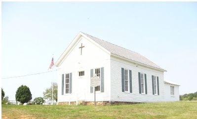
Asbury Church and Marker
| On Fleetwood Drive (County Route 611), on the right when traveling south. |
| Near Quantico Marine Corps Base. |
| On Aden Road (County Route 646) at Leeta Cornus Lane, on the left when traveling east on Aden Road. |
| On Deepwood Lane, 0.4 miles east of Fleetwood Drive, on the right when traveling east. |
| On Waterfall Road (Virginia Route 601), on the right when traveling east. |
| On Mine Road, 0.9 miles north of Victoria Falls Drive, on the left when traveling north. |
| On Mine Road, 0.9 miles north of Victoria Falls Drive, on the left when traveling north. |
| On Minnieville Road (Route 640) 0.1 miles west of Smoketown Road, on the right when traveling west. |
| On Potomac Mills Circle at Bidderford Way, on the left when traveling north on Potomac Mills Circle. |
| On Bristow Road (Virginia Route 619) 4.2 miles east of Nokesville Road (Virginia Route 28), on the right when traveling west. |
| On Bridwell Drive at Old Church Road, on the left when traveling east on Bridwell Drive. |
| On 10th Alabama Avenue at Iron Brigade Unit, on the left when traveling west on 10th Alabama Avenue. |
| On Chapel Springs Road at New Life Way, on the right when traveling north on Chapel Springs Road. |
| On James Madison Highway (U.S. 15) at Madison Ridge Place, on the right when traveling south on James Madison Highway. |
| On Lee Highway (U.S. 29) at Buckland Mill Road (County Route 684), on the right when traveling south on Lee Highway. |
| On Sudley Road (State Road 234), on the right when traveling north. |
| On Sudley Road (Virginia Route 234) 1.6 miles north of Lee Highway, formerly Warrenton Turnpike (U.S. 29), on the left when traveling north. |
| On Benita Fitzgerald Drive, 0.1 miles south of Dale Boulevard, on the right when traveling south. |
| On Minnieville Road (Local Route 640) north of Prince William Parkway (County Route 3000), on the right when traveling south. |
| On Neabsco Church Way near Bushey Drive, on the right when traveling west. |
| On Smoketown Road east of Minnieville Road (Local Route 640), on the right when traveling east. |
| Near Benita Fitzgerald Drive, 0.1 miles south of Broker Lane, on the right when traveling east. |
| On Frayley Boulevard (U.S. 1) north of Williamstown Drive, on the right when traveling north. |
| On Virginia Oaks Drive just south of Lee Highway (U.S. 29), on the right when traveling south. |
| On Washington Street (Virginia Route 55) at Fayette Street, on the left when traveling west on Washington Street. |
| On James Madison Highway (U.S. 15) 0.6 miles south of Sudley Road (Virginia Route 234), on the right when traveling south. |
| On Davis Ford Road (Virginia Route 694) at Bacon Race Road, on the left when traveling west on Davis Ford Road. |
| On Davis Ford Road (Virginia Route 694) at Bacon Race Road, on the right when traveling north on Davis Ford Road. |
| On Antietam Road, on the left when traveling north. |
| On Minnieville Road (Local Route 640) at Old Bridge Road (Local Route 641), on the right when traveling north on Minnieville Road. |
| On Wolf Run Shoals Road north of Observer Lane, on the right. |
| On Cape Cod Court just west of Cape Cod Court, on the right when traveling west. |
| On Daniel K. Ludwig Drive, in the median. |
| On Jefferson Davis Highway (U.S. 1) north of Neabsco Road, on the right when traveling south. Reported missing. |
| On Brentsville Road, 0.2 miles south of Dumfries Road (Virginia Route 234), on the right when traveling south. |
| On Bethlehem Road, on the right when traveling south. |
| On Centreville Road (Virginia Route 28), on the right when traveling south. |
| On Centreville Road (Virginia Route 28), on the right when traveling north. |
| On General Washington Drive, 0.5 miles north of Minnieville Road. |
| On Delaney Road (Virginia Route 610) 0.2 miles north of Minnieville Road, on the right when traveling south. |
| On Minnieville Road (County Route 640) at Cardinal Drive, on the right when traveling north on Minnieville Road. |
| Near Waterway Drive, 0.2 miles east of Olivia Way, on the right when traveling east. |
| On Kapel Drive at Hope Hill Avenue, on the right when traveling south on Kapel Drive. |
| On Dumfries Road (Virginia Route 234) 0.2 miles east of Country Club Drive, on the right. |
| On Vlint Hill Road (State Road 215) at Burwell Road (County Route 604), on the right when traveling south on Vlint Hill Road. |
| On Aden Road (Virginia Route 646) 0.2 miles west of Brookfield Road, on the left when traveling west. |
| On Mill Street, on the right when traveling west. |
| On Washington Street (Virginia Route 253) at Mill Street, on the right when traveling north on Washington Street. |
| On Sudley Manor Drive east of Sudley Road (Virginia Route 234), on the right when traveling east. |
| On John Marshall Highway (Virginia Route 55) west of Thoroughfare Road, on the left when traveling west. |
| On Fuller Road (County Route 619) 0.1 miles east of Jefferson Davis Highway (U.S. 1), on the right when traveling east. |
| On Jefferson Davis Highway (U.S. 1) at Annapolis Way, on the right when traveling south on Jefferson Davis Highway. Reported permanently removed. |
| On Jefferson Davis Highway (U.S. 1) 0.1 miles south of Dale Blvd and Rippon Blvd, on the right when traveling south. |
| On Blackburn Road at Admiral Black Drive, on the right when traveling south on Blackburn Road. |
| On West Longview Drive north of Longview Drive, on the right when traveling north. |