389 entries match your criteria. Entries 201 through 300 are listed.⊲ Previous 100 — The final 89 ⊳
Former U.S. Presidents: #26 Theodore Roosevelt Historical Markers
By Cosmos Mariner, July 1, 2004
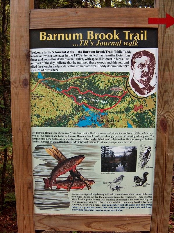
Teddy Roosevelt's Journal Walk Marker
| 201 ► New York, Franklin County, Paul Smiths — Teddy Roosevelt's Journal Walk — Barnum Brook Trail |
| Near Jenkins Mountain Road west of New York State Route 30, on the left when traveling west. Reported missing. | |||
| 202 ► New York, Franklin County, Saranac Lake — Making History in Saranac Lake — Heavyweights & Intellectuals — |
| On Bloomingdale Avenue (New York State Route 3) at Depot Street, on the right when traveling west on Bloomingdale Avenue. | |||
| 203 ► New York, Herkimer County, Jordanville — Public Library — |
| On Main Street (New York State Route 167) at Hyde-Bell Lane, on the left when traveling east on Main Street. | |||
| 204 ► New York, Nassau County, East Meadow — Medals of Honor Recipients Memorial — |
| Near Park Boulevard north of Route 24. | |||
| 205 ► New York, Nassau County, Oyster Bay — A Garden for Food and Color — Sagamore Hill National Historic Site — |
| Near Sagamore Hill Road, on the right when traveling north. | |||
| 206 ► New York, Nassau County, Oyster Bay — A Gentleman’s Farm, 1918 — Sagamore Hill National Historic Site — National Park Service, U.S. Department of the Interior — |
| Near Sagamore Hill Road, on the right when traveling north. | |||
| 207 ► New York, Nassau County, Oyster Bay — A Place in History — |
| Near Sagamore Hill Road, on the right when traveling north. | |||
| 208 ► New York, Nassau County, Oyster Bay — A Respite for Mrs. Roosevelt — Sagamore Hill National Historic Site — National Park Service, U.S. Department of the Interior — |
| Near Sagamore Hill Road, on the right when traveling north. | |||
| 209 ► New York, Nassau County, Oyster Bay — A Thoroughly Modern House — Sagamore Hill National Historic Site — National Park Service, U.S. Department of the Interior — |
| Near Sagamore Hill Road, on the right when traveling north. | |||
| 210 ► New York, Nassau County, Oyster Bay — Atop Sagamore Hill — |
| Near Sagamore Hill Road, on the right when traveling north. | |||
| 211 ► New York, Nassau County, Oyster Bay — Civil War Trophy Gun — |
| On Audrey Avenue at Shore Avenue, on the left when traveling north on Audrey Avenue. | |||
| 212 ► New York, Nassau County, Oyster Bay — End of An Era — |
| On Shore Avenue at Audrey Avenue, on the right when traveling west on Shore Avenue. | |||
| 213 ► New York, Nassau County, Oyster Bay — Helping Feed the Family — Sagamore Hill National Historic Site — National Park Service, U.S. Department of the Interior — |
| Near Sagamore Hill Road, on the right when traveling north. | |||
| 214 ► New York, Nassau County, Oyster Bay — Matinecock Lodge — |
| On W Main Street west of South Street, on the right when traveling west. | |||
| 215 ► New York, Nassau County, Oyster Bay — Nature Trail and Woodland — Sagamore Hill National Historic Site — National Park Service, U.S. Department of the Interior — |
| Near Sagamore Hill Road, on the right when traveling north. | |||
| 216 ► New York, Nassau County, Oyster Bay — Old Orchard Home — |
| Near Sagamore Hill Road, on the right when traveling north. | |||
| 217 ► New York, Nassau County, Oyster Bay — On the Farm — |
| On Sagamore Hill Road, on the right when traveling north. | |||
| 218 ► New York, Nassau County, Oyster Bay — Oyster Bay Railroad Station |
| On Audrey Avenue. Reported missing. | |||
| 219 ► New York, Nassau County, Oyster Bay — Oyster Bay WWI Memorial — |
| On South Street (County Route 106) at Lexington Avenue / Berry Hill Road, on the left when traveling south on South Street. | |||
| 220 ► New York, Nassau County, Oyster Bay — Presbyterian Church — |
| On E Main Street near Church Street, on the right when traveling east. | |||
| 221 ► New York, Nassau County, Oyster Bay — Quentin Roosevelt — |
| Near Sagamore Hill Road, on the right when traveling east. | |||
| 222 ► New York, Nassau County, Oyster Bay — Roosevelt Memorial Oak — |
| Near Railroad Avenue, on the left when traveling east. | |||
| 223 ► New York, Nassau County, Oyster Bay — Roosevelt Memorial Rocks — |
| On Railroad Avenue, on the left when traveling east. | |||
| 224 ► New York, Nassau County, Oyster Bay — Roosevelts at Play — Sagamore Hill National Historic Site — National Park Service, U.S. Department of the Interior — |
| On Sagamore Hill Road, on the right when traveling north. | |||
| 225 ► New York, Nassau County, Oyster Bay — Sagamore Hill — |
| On Sagamore Hill Road, on the right when traveling north. | |||
| 226 ► New York, Nassau County, Oyster Bay — Sagamore Hill National Historic Site — National Park Service — |
| On Sagamore Hill Road, on the right when traveling north. | |||
| 227 ► New York, Nassau County, Oyster Bay — Sagamore Hill National Historic Site — National Park Service — |
| Near Sagamore Hill Road, on the right when traveling north. | |||
| 228 ► New York, Nassau County, Oyster Bay — The First Building — Sagamore Hill National Historic Site — National Park Service, U.S. Department of the Interior — |
| Near Sagamore Hill Road, on the right when traveling north. | |||
| 229 ► New York, Nassau County, Oyster Bay — The Funeral of Theodore Roosevelt — January 8, 1919 — |
| Near Cove Road at Cove Neck Road, on the right when traveling east. | |||
| 230 ► New York, Nassau County, Oyster Bay — Theodore Roosevelt — |
| Near Sagamore Hill Road, on the right when traveling east. | |||
| 231 ► New York, Nassau County, Oyster Bay — Theodore Roosevelt — 1858 - 1919 — |
| On Audrey Avenue at Shore Avenue, on the left when traveling south on Audrey Avenue. | |||
| 232 ► New York, Nassau County, Oyster Bay — 636 — Theodore Roosevelt — |
| On Cove Road, 1.7 miles north of New York State Route 25A, on the right when traveling east. | |||
| 233 ► New York, Nassau County, Oyster Bay — Theodore Roosevelt Memorial Park — |
| On Railroad Avenue, on the left when traveling east. | |||
| 234 ► New York, Nassau County, Oyster Bay — Theodore Roosevelt Memorial Park — |
| On West End Avenue at Larrabee Avenue, on the left when traveling north on West End Avenue. | |||
| 235 ► New York, Nassau County, Oyster Bay — Theodore Roosevelt Rough Rider Statue — |
| On South Street (County Route 106) at Lexington Avenue / Berry Hill Road, on the left when traveling south on South Street. | |||
| 236 ► New York, Nassau County, Oyster Bay — Valued Family Friends — Sagamore Hill National Historic Site — National Park Service, U.S. Department of the Interior — |
| On Sagamore Hill Road, on the right when traveling north. | |||
| 237 ► New York, Nassau County, Westbury — Robert Bacon Memorial Children's Library — |
| On School Street at Jefferson Street, on the right when traveling north on School Street. | |||
| 238 ► New York, New York County, Manhattan, Battery Park — National Park Service Sites — |
| Near State Street south of Battery Place, on the right when traveling south. | |||
| 239 ► New York, New York County, Manhattan, East Village — The Cooper Union — 7 E(ast) 7(th Street) — Built 1852-1859 — |
| On Cooper Square at East 8th Street, on the right when traveling north on Cooper Square. | |||
| 240 ► New York, New York County, Manhattan, Financial District — June 18, 1910 — ★ — |
| On Broadway just north of Stone Street, on the right when traveling north. | |||
| 241 ► New York, New York County, Manhattan, Flatiron District — Theodore Roosevelt — |
| On East 20th Street, on the right when traveling east. | |||
| 242 ► New York, New York County, Manhattan, Flatiron District — Theodore Roosevelt Birthplace — |
| On East 20th Street east of Broadway, on the right when traveling east. | |||
| 243 ► New York, New York County, Manhattan, Gramercy Park — Augustus Saint-Gaudens — |
| On Second Avenue south of East 20th Street, on the right when traveling north. | |||
| 244 ► New York, New York County, Manhattan, Gramercy Park — Augustus Saint-Gaudens Playground — .643 acre — |
| On Second Avenue south of East 20th Street, on the left when traveling south. | |||
| 245 ► New York, New York County, Manhattan, Gramercy Park — Elihu Root — New York, Home of Distinguished Americans — February 15, 1845 - February 7, 1937 — |
| On Irving Place, on the right when traveling north. | |||
| 246 ► New York, New York County, Manhattan, Lenox Hill — Theodore Roosevelt Lived Here — 30 East 62nd Street — |
| On East 62nd Street at Madison Avenue, on the right when traveling west on East 62nd Street. | |||
| 247 ► New York, New York County, Manhattan, Little Italy — NYC's Oldest Operating Hotel — 146-8 Bowery — |
| On Bowery at Broome Street, on the right when traveling south on Bowery. | |||
| 248 ► New York, New York County, Manhattan, Nolita — Incubator For Art — YMCA Building — 222 Bowery — |
| On Bowery near Prince Street, on the right when traveling south. | |||
| 249 ► New York, New York County, Manhattan, Nolita — Lieutenant Joseph Petrosino — |
| On Kenmare Street near Cleveland Place, on the right when traveling west. | |||
| 250 ► New York, New York County, Manhattan, Nolita — Lieutenant Joseph Petrosino Park — .03 acre |
| On Kenmare Street at Cleveland Place, on the right when traveling north on Kenmare Street. Reported permanently removed. | |||
| 251 ► New York, New York County, Manhattan, Upper West Side — Addressing the Statue — |
| On Central Park West near 79th Street, on the right when traveling south. | |||
| 252 ► New York, New York County, Manhattan, Upper West Side — Theodore Roosevelt Park — 17.574 Acres — NYC Parks — |
| On West 81st Street east of Columbus Avenue, on the left when traveling west. | |||
| 253 ► New York, New York County, Manhattan, West Harlem — Roosevelt Triangle — 0.0035 acre — |
| On Morningside Avenue at Dr. Martin Luther King Jr. Boulevard, on the right when traveling south on Morningside Avenue. | |||
| 254 ► New York, New York County, Manhattan, West Village — Edwin Arlington Robinson — 1869 - 1935 — |
| On Washington Place west of 6th Avenue, on the left when traveling east. | |||
| 255 ► New York, Niagara County, Lockport — 10 — Lower Lock Construction — |
| On Canal Street near Pine Street. | |||
| 256 ► New York, Niagara County, North Tonawanda — 857 — Theodore Roosevelt — |
| On Webster Street at Main Street, on the left when traveling north on Webster Street. | |||
| 257 ► New York, Putnam County, Philipstown, Constitution Island — The Warner House — |
| 258 ► New York, Queens County, Queens, Flushing — Flushing Town Hall — Flushing Freedom Mile — |
| On Northern Boulevard (New York State Route 25A) just east of Linden Place, on the right when traveling west. | |||
| 259 ► New York, Queens County, Queens, Richmond Hill — Church of the Resurrection — |
| On 118th Street just south of 85th Avenue, on the right when traveling north. | |||
| 260 ► New York, Rockland County, Orangeburg — John G. Bell — |
| On Kings Highway. | |||
| 261 ► New York, Rockland County, Stony Point — The Palisades Interstate Parkway Scenic Byway Corridor — |
| On Palisades Interstate Parkway, in the median. | |||
| 262 ► New York, Rockland County, Tappan — The Palisades Interstate Parkway Scenic Byway Corridor — |
| On Palisades Interstate Pkwy, in the median. | |||
| 263 ► New York, Saratoga County, Ballston — Hawkwood Mansion — The Early Years — |
| Near Middle Line Road. | |||
| 264 ► New York, Saratoga County, Saratoga Springs — Saratoga State Seal Waters — A Quest for Good Health — |
| Near Avenue of the Pines. | |||
| 265 ► New York, Warren County, North Creek — Johnsburg — |
| On Main Street (County Route 77) at Ski Bowl Road, on the right when traveling north on Main Street. | |||
| 266 ► New York, Warren County, North Creek — North Creek Depot — |
| 267 ► New York, Warren County, North Creek — North Creek Railway Station — |
| On Railroad Place, on the right when traveling west. | |||
| 268 ► New York, Warren County, North Creek — Theodore Roosevelt — Family Man - Conservationist — |
| Near Railroad Place, on the right when traveling north. | |||
| 269 ► New York, Warren County, North Creek — Theodore Roosevelt — Theodore Roosevelt in the Adirondacks — |
| On Railroad PLace, 0.1 miles east of Main Street, on the left when traveling east. | |||
| 270 ► New York, Warren County, North Creek — Theodore Roosevelt — Citizen Soldier, Steward to the Nation — |
| On Railroad Place, 0.1 miles east of Main Street, on the left when traveling east. | |||
| 271 ► North Carolina, Dare County, Rodanthe — Charles Kuralt Trail — Pea Island National Wildlife Refuge — |
| On State Highway 12, 4 miles south of Lifeboat Station Road, on the left when traveling south. | |||
| 272 ► North Carolina, Mecklenburg County, Charlotte, Charlotte center city — Mrs. "Stonewall Jackson" 1831-1915 — Charlotte Mecklenburg Historic Site |
| Near West Trade Street at South Polar Street. Reported missing. | |||
| 273 ► North Dakota, Billings County, Medora — 6 — Cowboys — |
| On 3rd Avenue at Main Street, on the right when traveling east on 3rd Avenue. | |||
| 274 ► North Dakota, Billings County, Medora — 9 — Hunting and Trapping — |
| On Pacific Avenue at 3rd Street, on the right when traveling east on Pacific Avenue. | |||
| 275 ► North Dakota, Billings County, Medora — In honor of a President . . . and His Conservation Legacy — |
| On Easy River Road, on the left when traveling north. | |||
| 276 ► North Dakota, Billings County, Medora — 10 — Joe Ferris General Store — |
| On Main Street north of 3rd Avenue, on the right when traveling north. | |||
| 277 ► North Dakota, Billings County, Medora — 12 — Little Missouri: The Town — |
| On Pacific Avenue, on the right when traveling west. | |||
| 278 ► North Dakota, Billings County, Medora — 14 — Margaret Roberts — |
| On Broadway at 3rd Street, on the right when traveling east on Broadway. | |||
| 279 ► North Dakota, Billings County, Medora — 17 — Medora Depot & Railroad — |
| On Pacific Avenue at 3rd Street, on the right when traveling east on Pacific Avenue. | |||
| 280 ► North Dakota, Billings County, Medora — 24 — Rough Riders Hotel — |
| On 3rd Avenue near 3rd Street, on the right when traveling west. | |||
| 281 ► North Dakota, Billings County, Medora — 28 — The Bad Lands Cow Boy — |
| On Main Street at 3rd Avenue, on the left when traveling north on Main Street. | |||
| 282 ► North Dakota, Billings County, Medora — 29 — The President Returns — |
| On Broadway at 3rd Street, on the right when traveling west on Broadway. | |||
| 283 ► North Dakota, McKenzie County, Watford City — Roosevelt and the Boat Thieves — |
| On Scenic Drive. | |||
| 284 ► North Dakota, Stark County, Belfield — Dude on the Frontier — |
| Near Interstate I-94, on the right when traveling west. | |||
| 285 ► North Dakota, Stark County, Belfield — Invasion Confronted — Theodore Roosevelt National Park — National Park Service, U.S. Department of the Interior — |
| Near Interstate 94, on the right when traveling west. | |||
| 286 ► North Dakota, Stark County, Belfield — Welcome to Painted Canyon – A View into Theodore Roosevelt National Park — |
| Near Interstate 94, on the right when traveling west. | |||
| 287 ► North Dakota, Stark County, Dickinson — The Man — |
| On 3rd Street East just east of Sims Street, on the left when traveling east. | |||
| 288 ► North Dakota, Stark County, Dickinson — The Place — |
| On 3rd Street East just east of Sims Street, on the left when traveling east. | |||
| 289 ► North Dakota, Stark County, Dickinson — The Speech — |
| On 3rd Street East just east of Sims Street, on the left when traveling east. | |||
| 290 ► North Dakota, Ward County, Minot — Lt. Colonel Theodore Roosevelt — 1st United States Volunteer Cavalry, U.S. Army — |
| Near East Burdick Expressway (Business U.S. 2) at 13th Street Southeast, on the right when traveling west. | |||
| 291 ► Ohio, Athens County, Athens — Ohio University's Distinguished Visitors — |
| 292 ► Ohio, Belmont County, Bellaire — 15-7 — Union Square and its Uses / The Question of Ownership — |
| On Belmont Street, 0.1 miles north of 34th Street, on the right when traveling south. | |||
| 293 ► Ohio, Crawford County, Bucyrus — John Edward Hopley — |
| On East Mansfield Street (U.S. 30) at Penn Avenue, on the right when traveling west on East Mansfield Street. | |||
| 294 ► Ohio, Cuyahoga County, Westlake — 31-18 — Theodore Elijah Burton / Dover Farm — 1851–1929 / — |
| On Detroit Road (Ohio Route 254) just west of Walden Drive, on the right when traveling west. | |||
| 295 ► Ohio, Delaware County, Delaware — University Hall and Gray Chapel — |
| 296 ► Ohio, Franklin County, Columbus, Uptown District — Theodore Roosevelt Memorial Oak — Born October 27th, 1858 • Died January 6th, 1919 — |
| Near High Street south of Broad Street (U.S. 40), on the right. | |||
| 297 ► Ohio, Hamilton County, Cincinnati, Mount Auburn — 43-31 — William Howard Taft / Robert Alphonso Taft — |
| On Auburn Avenue, on the left when traveling south. | |||
| 298 ► Ohio, Miami County, Piqua — Public Square — Sign of the Past — |
| Near Main Street. | |||
| 299 ► Ohio, Scioto County, West Portsmouth, Washington Township — 11-73 — Theodore Roosevelt Game Preserve — Celebrating 100 Years of Conservation — |
| Near Route 125, 0.7 miles north of Mackletree Road, on the left when traveling north. | |||
| 300 ► Ohio, Shelby County, Sidney — Theodore Roosevelt / William Howard Taft — |
| On Main Street (Ohio Route 29/47), on the left when traveling north. | |||
389 entries matched your criteria. Entries 201 through 300 are listed above. ⊲ Previous 100 — The final 89 ⊳