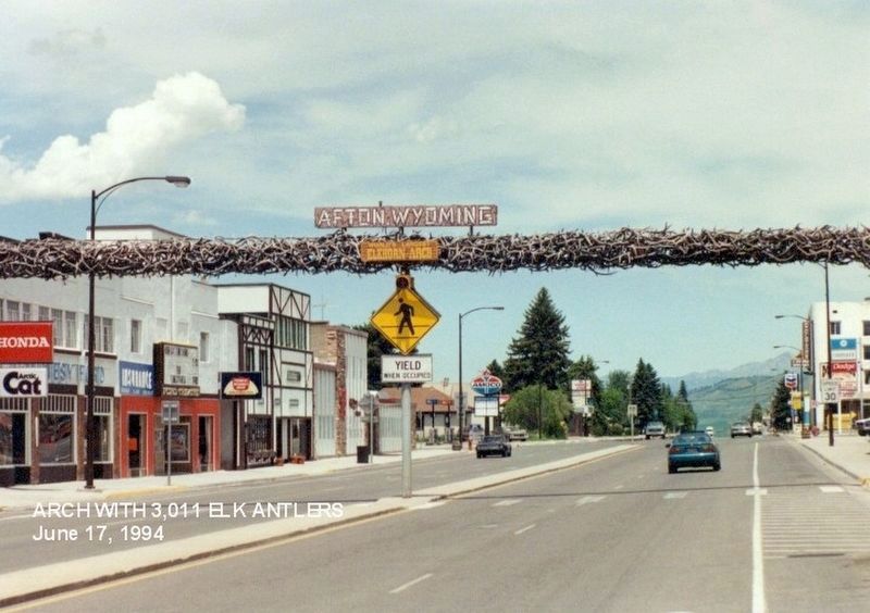
By Don Morfe, July 17, 1994
Afton Wyoming Marker
GEOGRAPHIC SORT Title Sort Marker Number Sort Marker Number Sort for Trails Publication Order Sort Publication Order Sort A Erected Year Sort Most Viewed Sort Most Recent-Interest Sort Most Recently Changed Sort SEE FAQ #33 FOR DESCRIPTIONS
On South Washington Street (US89).
On East 2nd Avenue, on the right when traveling east.
On Jefferson Street near East 3rd Avenue, on the left when traveling south.
On State Highway 241 near Dry Creek Road (County Route 146), on the right when traveling north.
On Jefferson Street near East 3rd Avenue, on the left when traveling south.
On U.S. 89 near River Circle, on the right when traveling north.
On Stump Creek Road, on the right when traveling west.
On U.S. 30 at milepost 11 near East Main Street (Wyoming Highway 232), on the right when traveling north.
On Dempsey Road 1 mile west of Farm Field Road, on the left when traveling west.
On U.S. 30 near Wyoming Highway 89, on the right when traveling west.
On U.S. 30 near East Main Street (Wyoming Highway 232), on the right when traveling north.
On U.S. 30 near Wyoming Highway 89, on the right when traveling west.
On East Main Street at Park Street, on the left when traveling west on East Main Street.
On U.S. 89 near Etna-Forest County Road 112 (County Route 169), on the left when traveling north.
On Farm Field Road 2 miles east of Dempsey Road, on the right when traveling east.
Paid Advertisement
On U.S. 30 5.3 miles west of U.S. 189, on the right when traveling west.
On J.C. Penney Drive at Lignite Street, on the right when traveling west on J.C. Penney Drive.
On South Main Street at Pine Avenue, on the right when traveling east on South Main Street.
On Farm Field Road 1 mile east of Dempsey Road, on the right when traveling east.
On J C Penney Drive at Pine Avenue (U.S. 189), on the right when traveling east on J C Penney Drive.
On Pine Avenue (U.S. 189), on the right when traveling north.
On U.S. 189 5.6 miles south of State Highway 235, on the right when traveling south.
On U.S. 189 5.6 miles south of State Highway 235, on the right when traveling south.
On U.S. 189 near Bondurant Road, on the right when traveling south.
On U.S. 189 12.8 miles north of State Highway 372, on the right when traveling north.
On U.S. 89 near Forest Road 100072, on the right when traveling north.
On U.S. 89 near Gomm's Pond Lane, on the right when traveling north.
On U.S. 89, on the right when traveling north.
On U.S. 89 near Salt River Ranch Lane, on the right when traveling north.
Paid Advertisement
On North Main Street (U.S. 89) near Wright Street, on the left when traveling north.
On Dana Street, on the right when traveling west.
On U.S. 89 0.2 miles north of Strawberry Creek Road (County Route 126), on the right when traveling north.
On Belfry Highway (State Highway 120) near State Highway 292, on the right when traveling south.
On State Highway 120 near State Highway 292.
On Belfry Highway (State Highway 120) near State Highway 292, on the right when traveling south.
On State Highway 120 near State Highway 292, on the left when traveling south.
On Powell Highway (Alternate U.S. 14) near Happy Trails Road, on the left when traveling north.
Near W Yellowstone Avenue (U.S. 20), on the right when traveling west.
On North Fork Hwy (U.S. 14) 1.2 miles east of Verner Road, on the right when traveling east.
On North Fork Hwy (U.S. 14) 1.2 miles east of Verner Road, on the right when traveling east.
Near Demaris Drive near West Yellowstone Avenue (U.S. 14).
On North Fork Hwy (U.S. 14) 1.3 miles east of Verner Road, on the right when traveling east.
On North Fork Hwy (U.S. 14) 0.5 miles east of Verner Road, on the right when traveling east.
On Southfork Road (State Highway 291) near Davis Draw Road, on the right when traveling south.
Near W Yellowstone Avenue (U.S. 20), on the right when traveling west.
Paid Advertisement
On W Yellowstone Avenue (U.S. 20), on the right when traveling west.
On W Yellowstone Avenue (U.S. 20) west of Demaris Drive, on the right when traveling west.
On Dead Indian Hill Road (aka Crandall Road) (State Highway 296) near County Highway 103, on the right when traveling west.
On Dead Indian Hill Road (aka Crandall Road) (State Highway 296) near County Highway 103, on the right when traveling west.
On Sheridan Avenue at 8th Street, on the right when traveling west on Sheridan Avenue.
On Powell Highway (Alternate U.S. 14) near Happy Trails Road, on the left when traveling north.
On Rumsey Avenue, on the left when traveling west.
On W Yellowstone Avenue (U.S. 20) 0.1 miles west of Demaris Drive, on the right when traveling west.
Near Demaris Drive near West Yellowstone Avenue (U.S. 14).
Near Demaris Drive near West Yellowstone Avenue (U.S. 14).
Near W Yellowstone Avenue (U.S. 20), on the right when traveling west.
On W Yellowstone Avenue (U.S. 20) 0.1 miles west of Demaris Drive, on the right when traveling west.
On Demaris Drive near West Yellowstone Avenue (U.S. 14).
On Dead Indian Hill Road (aka Crandall Road) (State Highway 296) near County Road 103, on the right when traveling west.
On Greybull Highway at Lt. Childers St., on the right when traveling west on Greybull Highway.
Near Demaris Drive near West Yellowstone Avenue (U.S. 14).
Paid Advertisement
On Sheridan Avenue, on the left when traveling west.
On Greybull Highway at Lt. Childers Street, on the right when traveling west on Greybull Highway.
On Greybull Highway at Lt. Childers Street, on the right when traveling west on Greybull Highway.
On Greybull Highway at Lt. Childers Street, on the right when traveling west on Greybull Highway.
Near Demaris Drive near West Yellowstone Avenue (U.S. 14).
On Greybull Highway at Lt. Childers Street, on the right when traveling west on Greybull Highway.
On W Yellowstone Avenue (U.S. 20), on the right when traveling west.
On N Fork Hwy (U.S. 20) 0.2 miles west of Spirit Mountain Road, on the right when traveling west.
On Sheridan Avenue at 11th Street, on the left when traveling west on Sheridan Avenue.
On Greybull Hwy./U.S. 85 at Lt. Childers Street, on the right when traveling west on Greybull Hwy./U.S. 85.
Near W Yellowstone Avenue (U.S. 20), on the right when traveling west.
Near Demaris Drive near West Yellowstone Avenue.
On Dead Indian Hill Road (aka Crandall Road) (State Highway 296) near County Road 103, on the right when traveling west.
On W Yellowstone Avenue (U.S. 20) 0.1 miles west of Demaris Drive, on the right when traveling west.
Near Sheridan Avenue near 8th Street, on the left when traveling west.
On Greybull Highway near Lt. Childers Street, on the right when traveling west.
Paid Advertisement
On Greybull Hwy. at Lt. Childers Street, on the right when traveling west on Greybull Hwy..
Near W Yellowstone Avenue (U.S. 20), on the right when traveling west.
On North Fork Hwy (U.S. 14) 1.2 miles east of Verner Road, on the right when traveling east.
Near Demaris Drive near West Yellowstone Avenue (U.S. 14).
Near W Yellowstone Avenue (U.S. 20) 0.1 miles Demaris Drive, on the right when traveling west.
Near Greybull Highway, on the left when traveling east.
On Greybull Highway at Lt. Childers Street, on the right when traveling west on Greybull Highway.
On Greybull Hwy at Lt. Childers Street, on the right when traveling west on Greybull Hwy.
On Sheridan Avenue, on the left when traveling west.
On Beartooth Highway (U.S. 212) 9 miles west of Crandall Road (State Highway 296), on the right when traveling west.
On NE Entrance Road (U.S. 212), on the right when traveling east.
On Unnamed Road 0.1 miles south of North Entrance Road and upper Grand Loop Road, on the left when traveling south. Reported permanently removed.
On Officer's Row 0.2 miles south of North Entrance Road - eastbound lanes, on the right when traveling north. Reported permanently removed.
On Grand Loop Road - Upper Loop 0.2 miles south of Grand Loop Road - Lower Loop & North Entrance Road, on the left when traveling south. Reported permanently removed.
On Officer's Row 0.1 miles Mammoth Street, on the left when traveling south. Reported permanently removed.
On Unnamed Road 0.2 miles south of North Entrance Road and upper Grand Loop Road, on the left when traveling south. Reported permanently removed.
Paid Advertisement
On Officer's Row 0 miles south of Mammoth Street, on the left when traveling south. Reported permanently removed.
On North Entrance Road 0 miles east of Grand Loop Road, on the right when traveling west. Reported permanently removed.
On Unnamed Road at North Entrance Road and upper Grand Loop Road, on the right when traveling south on Unnamed Road. Reported permanently removed.
On North Entrance Road at Grand Loop Road - upper loop, on the left when traveling south on North Entrance Road. Reported permanently removed.
On State Highway 120 at Mary Avenue, on the left when traveling south on State Highway 120.
︽
384 entries matched your criteria. The first 100 are listed above.
Next 100 ⊳