80 entries match your criteria.
Communal and Utopian Societies Historical Markers
The US Library of Congress notes that although "the word 'utopia' is often associated with science fiction, utopian communities were a common fixture in nineteenth century America. Incorporating unique religious and social ideals, these communities grew rapidly during the nineteenth century before declining in the early twentieth century." This series includes markers highlighting communal and utopian societies throughout the world, whether they were religiously focused or secular.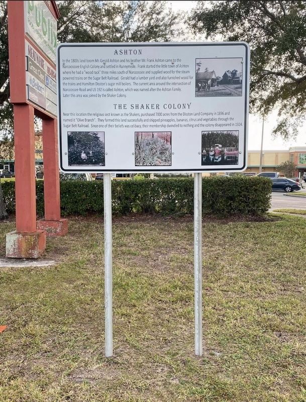
By Diane Murphy, February 2023
Ashton Marker
| 1 ► Florida, Osceola County, St. Cloud — Ashton — |
| On Narcoossee Road (County Route 15) 0.1 miles north of E Irlo Bronson Memorial Highway (U.S. 192), on the right when traveling north. | |||
| 2 ► Indiana, Knox County, Oaktown — Shakertown — |
| On U.S. 41 at East Gauger Road, on the right when traveling south on U.S. 41. | |||
| 3 ► Indiana, Posey County, New Harmony — In Perfect Harmony — Ohio River Scenic Byway • Posey County, Indiana — |
| On Arthur Street north of Church Street, on the left when traveling north. | |||
| 4 ► Indiana, Posey County, New Harmony — New Harmony — |
| On Church Street (State Road 66) at Main Street, on the right when traveling west on Church Street. | |||
| 5 ► Indiana, Posey County, New Harmony — 65.1966.1 — New Harmony — |
| On Church Street (State Road 66) east of Main Street, on the right when traveling east. | |||
| 6 ► Indiana, Posey County, New Harmony — 65.2001.1 — New Harmony Workingmen's Institute — |
| On Tavern Street west of Main Street, on the left when traveling west. | |||
| 7 ► Indiana, Posey County, New Harmony — New Harmony, Indiana (1814-1827) — |
| On Church Street (State Road 66) at Main Street, on the right when traveling west on Church Street. | |||
| 8 ► Indiana, Posey County, New Harmony — Rappite Community House No. 2 — Erected 1816 - 1822 — |
| On Main Street north of Church Street (State Road 66), on the right when traveling north. | |||
| 9 ► Kentucky, Henry County, Pleasureville — 852 — Dutch Colony Here — |
| On Castle Highway (U.S. 421) south of Main Street (Route 241), on the left when traveling south. | |||
| 10 ► Kentucky, Logan County, Auburn — Site of 1818 Meeting House — |
| On Shaker Museum Road west of Shakertown Road, on the left when traveling west. | |||
| 11 ► Kentucky, Logan County, South Union — 1869 Shaker Tavern — |
| On South Union Road (Kentucky Route 73) 0.1 miles south of C Duncan Road, on the left when traveling south. | |||
| 12 ► Kentucky, Logan County, South Union — 1917 Store and Post Office — |
| On South Union Road (Kentucky Route 73) 0.1 miles south of C Duncan Road, on the right when traveling south. | |||
| 13 ► Kentucky, Logan County, South Union — 1455 — Shaker Colony — |
| On Shaker Museum Road west of Shakertown Road (Kentucky Route 1466), on the right when traveling west. | |||
| 14 ► Kentucky, Logan County, South Union — Site of 1834 North House — |
| On Shakertown Road (Kentucky Route 1466) 0.3 miles north of Shaker Museum Road, on the right when traveling north. | |||
| 15 ► Kentucky, Logan County, South Union — Site of Ca. 1840 Brethern’s Shop — |
| On Shakertown Road (Kentucky Route 1466), on the right when traveling north. | |||
| 16 ► Kentucky, Logan County, South Union — South Union Cemetery — |
| On Shakertown Road (Kentucky Route 1466) 0.4 miles south of Bowling Green Road (U.S. 68), on the right when traveling south. | |||
| 17 ► Kentucky, Logan County, South Union — 716 — The Shaker Tavern — |
| On South Union Road (Kentucky Route 73) south of C Duncan Road, on the left when traveling south. | |||
| 18 ► Kentucky, Mercer County, Harrodsburg — 42 — Honeysuckle Hill / Fair Oaks — |
| On Beaumont Avenue just south of Runyon Road, on the left when traveling north. | |||
| 19 ► Kentucky, Mercer County, Harrodsburg, Shakertown — 627 — "Morgan's Men" Here — Confederate Raids and Invasions and a Federal Retreat, in Kentucky. — |
| On West Lot Road west of Shakertown Road, on the right when traveling west. | |||
| 20 ► Kentucky, Mercer County, Harrodsburg, Shakertown — 1816 — Old Mail Stage Route — |
| Near West Lot Road west of Shakertown Road, on the right when traveling west. | |||
| 21 ► Kentucky, Mercer County, Harrodsburg, Shakertown — 1817 — Shaker Landing / Shaker Landing Road — |
| On Shakers Ferry Road east of Lexington Road (U.S. 68). | |||
| 22 ► Kentucky, Mercer County, Harrodsburg, Shakertown — 1481 — Shakertown at Pleasant Hill — |
| On West Lot Road north of Shakertown Road, on the right when traveling west. | |||
| 23 ► Maine, York County, Saco — Jacob Cochran, 1782-1836 — Saco Main Street Museum Walk — |
| On Beach Street (Maine Route 9) at Main Street, on the right when traveling east on Beach Street. | |||
| 24 ► Massachusetts, Berkshire County, Pittsfield — Hancock Shaker Village — |
| 25 ► Massachusetts, Berkshire County, Pittsfield — Hancock Shaker Village: Powered by the Sun for Over 200 Years — |
| 26 ► Massachusetts, Berkshire County, Pittsfield — Shaker Color — |
| 27 ► New Hampshire, Grafton County, Enfield — Downtown Enfield Village — |
| On Main Street at Blacksmith Alley, on the right when traveling east on Main Street. | |||
| 28 ► New Hampshire, Grafton County, Enfield — The Enfield Shakers — |
| On New Hampshire Route 4A at Caleb Dyer Lane, on the right when traveling south on State Route 4A. | |||
| 29 ► New Hampshire, Merrimack County, Loudon — Shaker Village — |
| On Rocky Pond Road (New Hampshire Route 106) at Shaker Road, on the right when traveling north on Rocky Pond Road. | |||
| 30 ► New York, Albany County, Albany — 1816 Dwelling House — |
| Near Meeting House Rd east of Heritage Ln (Local Route 151). | |||
| 31 ► New York, Albany County, Albany — America's First Shaker Settlement — |
| On Heritage Lane (New York State Route 151) at Meeting House Road, on the left when traveling south on Heritage Lane. | |||
| 32 ► New York, Albany County, Albany — Brethren's Workshop (1822) — |
| On Meeting House Road, on the left when traveling north. | |||
| 33 ► New York, Albany County, Albany — Creamery (1856) — |
| 34 ► New York, Albany County, Albany — Ministry Shop (1825) — |
| 35 ► New York, Albany County, Albany — Mother Ann Lee — 1736 - 1784 — |
| On Meeting House Road, on the left when traveling north. | |||
| 36 ► New York, Albany County, Albany — Shaker Garage (1920) — |
| 37 ► New York, Albany County, Albany — Shaker Heritage Society Garden — Come in. — |
| 38 ► New York, Albany County, Albany — Shaker Meeting House — |
| On Meeting House Road, on the right when traveling north. | |||
| 39 ► New York, Albany County, Albany — Sisters' Workshop (1840) — |
| 40 ► New York, Albany County, Albany — Wash House & Cannery (c.1858) — |
| On Meeting House Road, on the left when traveling east. | |||
| 41 ► New York, Albany County, Colonie — Fox Preserve — |
| On River Road, 0.2 miles west of Forts Ferry Road, on the right when traveling east. | |||
| 42 ► New York, Albany County, Colonie — Shaker Cemetery — |
| On Heritage Lane, 0.1 miles east of Airline Drive, on the right when traveling west. | |||
| 43 ► New York, Albany County, Colonie — Shaker Church Family Barn — |
| On Heritage Lane (County Route 151) at Meeting House Road, on the right when traveling north on Heritage Lane. | |||
| 44 ► New York, Livingston County, Mt. Morris — Genesee Valley Greenway — A Transportation Corridor for Generations — |
| Near East State Street (New York State Route 408) at Genesee Street. | |||
| 45 ► New York, Livingston County, Sonyea — Site of the Groveland Shaker Community — Historic New York — |
| On Moyer Road at Brill Drive, on the left when traveling south on Moyer Road. | |||
| 46 ► New York, Livingston County, Sonyea — Sonyea Shaker Community — |
| On Sonyea Road (New York State Route 36) 0.2 miles east of Ridge Road, on the right when traveling south. | |||
| 47 ► Ohio, Cuyahoga County, Cleveland, Buckeye - Shaker — Shaker Gate Post — Period 1830 — |
| On South Moreland Boulevard at Shaker Square, in the median on South Moreland Boulevard. | |||
| 48 ► Ohio, Cuyahoga County, Cleveland, Buckeye - Shaker — Shaker Gristmill Site — |
| On Fairhill Road near East 127th Street, on the right when traveling west. | |||
| 49 ► Ohio, Cuyahoga County, Cleveland, Buckeye - Shaker — Shaker Mill Stone — Period 1837 — |
| On North Moreland Boulevard near Shaker Boulevard (Ohio Route 87), in the median. | |||
| 50 ► Ohio, Cuyahoga County, Shaker Heights — East Family — North Union Society of Shakers — December 3, 1837 - September 23, 1872 — |
| On Fontenay Road, 0.2 miles south of Shaker Boulevard (Ohio Route 87), in the median. | |||
| 51 ► Ohio, Cuyahoga County, Shaker Heights — 67-18 — Horseshoe Lake — |
| On South Park Boulevard, 0.2 miles east of Lee Road, on the right when traveling east. | |||
| 52 ► Ohio, Cuyahoga County, Shaker Heights — Shaker Gate Posts — Period 1830 — |
| On Lee Road at Shaker Boulevard (Ohio Route 87), on the right when traveling south on Lee Road. | |||
| 53 ► Ohio, Cuyahoga County, Shaker Heights — Site of Center Family — North Union Society of Shakers — |
| On Lee Road at Chagrin Road (Ohio Route 87), on the right when traveling east on Lee Road. | |||
| 54 ► Ohio, Cuyahoga County, Shaker Heights — This Tablet Marks the Final Resting Place of the Shakers of the North Union Society — |
| Near Lee Road north of Chagrin Road (U.S. 422), on the right when traveling north. | |||
| 55 ► Ohio, Cuyahoga County, Shaker Heights — Warrensville West Cemetery — First Burial 1811 — |
| On Lee Road north of Chagrin Boulevard (U.S. 422), on the right when traveling north. | |||
| 56 ► Ohio, Montgomery County, Dayton, University Park — Watervliet Shaker Building — |
| Near Carillon Boulevard, 0.2 miles west of South Patterson Boulevard, on the left when traveling west. | |||
| 57 ► Ohio, Montgomery County, Kettering — 6-57 — Watervliet Shaker Community — |
| On Research Boulevard/County Line Road (Ohio Route 835) 0.1 miles north of Shakertown Road, on the left when traveling north. | |||
| 58 ► Ohio, Warren County, Lebanon — The First And Largest Western Shaker Village — |
| On S. Broadway Street, on the right when traveling north. | |||
| 59 ► Ohio, Warren County, Lebanon — 2-83 — Union Village — (1805 - 1912) — |
| On Ohio Route 741 at Shaker Drive, on the right when traveling north on State Route 741. | |||
| 60 ► Pennsylvania, Beaver County, Ambridge — Blacksmith and Wagonmaker Shops — |
| On 15th Street at Merchant Street, on the right when traveling west on 15th Street. | |||
| 61 ► Pennsylvania, Beaver County, Ambridge — Carriage House and Summer Kitchen — |
| On Church Street at Creese Street, on the right when traveling north on Church Street. | |||
| 62 ► Pennsylvania, Beaver County, Ambridge — Distillery, Cider Press, and Laundry — |
| On 15th Street at Merchant Street, on the right when traveling west on 15th Street. | |||
| 63 ► Pennsylvania, Beaver County, Ambridge — Economy Hotel — |
| On Merchant Street at 14th Street, on the right when traveling south on Merchant Street. | |||
| 64 ► Pennsylvania, Beaver County, Ambridge — First Harmonist Church and Fire Department — |
| On 15th Street east of Church Street, on the right when traveling west. | |||
| 65 ► Pennsylvania, Beaver County, Ambridge — Greenhouse and Bakery — |
| On 13th Street at Church Street, on the right when traveling east on 13th Street. | |||
| 66 ► Pennsylvania, Beaver County, Ambridge — Harmonist Church / St. John's Lutheran Church — |
| On Church Street at Creese Street, on the right when traveling south on Church Street. | |||
| 67 ► Pennsylvania, Beaver County, Ambridge — Harmony Society Cemetery — 1824-1951 — |
| Near Church Street. | |||
| 68 ► Pennsylvania, Beaver County, Ambridge — Harmony Society Church — |
| On Church Street at Creese Street, on the right when traveling north on Church Street. | |||
| 69 ► Pennsylvania, Beaver County, Ambridge — Old Economy — |
| On Church Street, on the left when traveling north. | |||
| 70 ► Pennsylvania, Beaver County, Ambridge — Old Economy Memorial — |
| On Ohio River Boulevard (Pennsylvania Route 65) 0.1 miles south of 15th Street, on the right when traveling south. | |||
| 71 ► Pennsylvania, Beaver County, Ambridge — Schools — |
| Near Church Street at Laughlin Street. | |||
| 72 ► Pennsylvania, Beaver County, Ambridge — The Harmonist Wool Block — |
| On Church Street south of 13th Street, on the right when traveling north. | |||
| 73 ► Pennsylvania, Beaver County, Ambridge — Water Pump, Bank, Restaurant, Croatian Club — |
| On Merchant Street at 14th Street, on the right when traveling north on Merchant Street. | |||
| 74 ► Pennsylvania, Butler County, Harmony — Harmonist - Ziegler Barn — 1805 — |
| Near Mercer Road at Seneca Drive. | |||
| 75 ► Pennsylvania, Butler County, Harmony — Harmonist Cemetery — |
| On Evans City Road (Pennsylvania Route 68) 0.3 miles west of Raymond P. Shafer Highway (Interstate 79), on the right when traveling east. | |||
| 76 ► Pennsylvania, Butler County, Harmony — Harmony — |
| On Main Street at Mercer Street, on the right when traveling north on Main Street. | |||
| 77 ► Pennsylvania, Butler County, Harmony — Harmony Mennonites — |
| On Wise Road, on the right when traveling east. | |||
| 78 ► Pennsylvania, Butler County, Harmony — Rapp's Seat Vineyard Hill — |
| On Evergreen Mill Road, on the left when traveling east. | |||
| 79 ► Vermont, Chittenden County, Shelburne — Round Barn — 1901 • Fred Quimby • East Passumpsic, Vermont — Moved to Museum: 1985-1986 — |
| 80 ► Vermont, Chittenden County, Shelburne — Shaker Shed — 1840 • Canterbury, New Hampshire — Moved to Museum: 1951 — |