64 entries match your criteria.
Entries Containing All of the Phrases «travis county» AND «texas»
By James Hulse, August 29, 2022
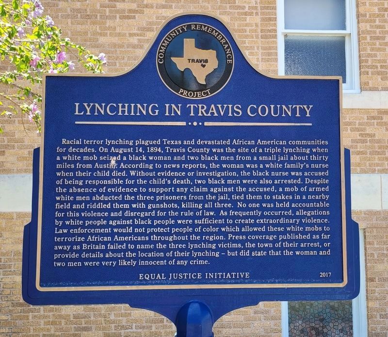
Lynching in Travis County side of the Marker
RANKED BY RELEVANCE
1 ► Texas, Travis County, Austin, Central East Austin — Lynching in America / Lynching in Travis County — Community Remembrance Project —  |
| On San Bernard Street at Hackberry Street, on the right when traveling south on San Bernard Street. | |||
| 2 ► Texas, Travis County, Webberville, Webberwood — 14131 — James Euwin Edmiston — (1820-1892) — |
| Near Webberwood Way at Sandy Brown Lane. | |||
| 3 ► Texas, Travis County, Garfield — 14127 — Haynie Chapel Methodist Church — |
| On Greenwood Drive at Houston Road, on the right when traveling east on Greenwood Drive. | |||
| 4 ► Texas, Travis County, Austin, Downtown Austin — Heman Marion Sweatt — 1912-1982 — |
| On Guadalupe Street south of West 11th Street, on the right when traveling south. | |||
| 5 ► Texas, Travis County, Austin, Hyde Park — 15042 — Elvira T. Manor Davis House — |
| Near Avenue B north of West 41st Street, on the right when traveling north. | |||
| 6 ► Texas, San Saba County, San Saba — 18403 — James Louis & Eleanor Austin Baker — |
| Near State Highway 16 0.1 miles East Lewis Street. | |||
| 7 ► Texas, Travis County, Austin, Downtown Austin — 18370 — Sparks House — |
| On West Avenue at West 16th Street, on the left when traveling north on West Avenue. | |||
| 8 ► Texas, Travis County, Austin, Downtown Austin — 15026 — The Woman Suffrage Movement in Texas — |
| On Congress Avenue at W 11th Street, on the right when traveling north on Congress Avenue. | |||
| 9 ► Texas, Travis County, Austin, Mount Bonnell Terrace — 6473 — Mount Bonnell — |
| On Mount Bonnell Road 0.2 miles south of Mount Bonnell Drive, on the right when traveling south. | |||
| 10 ► Texas, Travis County, Austin, Pecan Springs-Springdale — The Texas Centennial Historic Marker & Fort Colorado — |
| Near East Martin Luther King Junior Boulevard. | |||
| 11 ► Texas, Travis County, Austin, Montopolis — Burditt Prairie Cemetery — Historic Cemetery — 1850 — |
| On Valdez Street at Felix Avenue, on the right when traveling north on Valdez Street. | |||
| 12 ► Texas, Travis County, Austin, Downtown Austin — Offices Of The War Department And The Adjutant General — The Republic of Texas — |
| On Congress Avenue near East 7th Street, on the right when traveling north. | |||
| 13 ► Texas, Bell County, Salado — 4348 — Major Archibald Johnson Rose — 1830 - 1903 — |
| On Rose Way Circle, on the right when traveling north. | |||
| 14 ► Texas, Brown County, Brownwood — 12549 — The Rev. Noah Turner Byars — |
| On Center Avenue at Austin Avenue, on the right when traveling north on Center Avenue. | |||
| 15 ► Texas, Hays County, Driftwood — William B. Travis Heritage Trail — |
| On Farm to Market Road 150 at Elder Hill Road, on the left when traveling south on Highway 150. | |||
| 16 ► Texas, Tarrant County, Fort Worth, Sylvan Heights West — 17068 — Tim Cole — 175 Years of Texas Independence • 1836 - 2011 — |
| Near Mount Olivet Cemetery 0.3 miles east of Morris Drive (County Road 1220), on the left when traveling east. | |||
| 17 ► Texas, Travis County, Austin, Central East Austin — 15675 — Swante Palm — (January 31, 1815 - June 22, 1899) — |
| Near Navasota Street north of East 14th Street, on the right when traveling north. | |||
| 18 ► Texas, Travis County, Austin, Downtown Austin — 15101 — Governor Andrew Jackson Hamilton — The First Republican Governor of Texas — |
| Near East 11th Street at Congress Avenue, on the right when traveling west. | |||
| 19 ► Texas, Travis County, Austin, Downtown Austin — 6426 — Third Site For Travis County Government — |
| On West 11th Street at Guadalupe Street, on the right when traveling south on West 11th Street. | |||
| 20 ► Texas, Wood County, Golden — 15501 — Reuben Leon and Fairess (Clark) Simmons — |
| On Farm to Market Road 779 at Farm to Market Road 1799, on the right when traveling east on Road 779. | |||
| 21 ► Texas, Matagorda County, Matagorda — 1357 — Early Texas Freighting — |
| On Fisher Street at Laurel Street, on the left when traveling west on Fisher Street. | |||
| 22 ► Texas, Travis County, Austin, Downtown Austin — 14770 — Gethsemane Church — |
| Near Congress Avenue at East 16th Street, on the right when traveling south. | |||
| 23 ► Texas, Travis County, Austin, East MLK — 14229 — Site of Fort Colorado — (Also called Coleman’s Fort) — |
| Near East Martin Luther King Jr Boulevard, on the right when traveling east. | |||
| 24 ► Texas, Blanco County, Johnson City — 16864 — Lyndon B. Johnson and Hill Country Electrification — |
| On South Avenue F south of East Elm Street, on the right when traveling north. | |||
| 25 ► Texas, Travis County, Austin, Downtown Austin — 14150 — Texas State Capitol — |
| On West 11th Street at Congress Avenue, on the right when traveling west on West 11th Street. | |||
| 26 ► Texas, Travis County, Austin, Comanche Canyon Ranch — 23385 — Comanche Peak — |
| On Comanche Trail at Monte Castillo Parkway, on the right when traveling west on Comanche Trail. | |||
| 27 ► Texas, Travis County, Austin, Downtown Austin — Pat Crow Memorial Plaza — |
| On Congress Avenue at W 10th St, on the left when traveling north on Congress Avenue. | |||
| 28 ► Texas, Travis County, Cedar Park, Twin Creeks — 14429 — John M. King Log House |
| Near Farm to Market Road 2769 west of Anderson Mill Road, on the right when traveling west. Reported missing. | |||
| 29 ► Texas, Travis County, Manor — 16578 — Littig Cemetery — |
| On Bitting School Road south of Littig Road, on the right when traveling south. | |||
| 30 ► Texas, Williamson County, Beyersville — 12371 — Mager Cemetery — |
| On FM-1466. | |||
| 31 ► Texas, Gillespie County, Fredericksburg — 10012 — Heinrich Bierschwale House — |
| On West Austin Street 0.1 miles west of North Crockett Street, on the left when traveling west. | |||
| 32 ► Texas, Bastrop County, Bastrop — 16095 — Josiah Pugh Wilbarger — In Memoriam — |
| Near State Hwy 95. | |||
| 33 ► Texas, Chambers County, Anahuac — 9135 — William Barret Travis — (August 9, 1809 - March 6, 1836) — |
| On Unnamed roads within the park at Unnamed roads within the park, on the right when traveling east on Unnamed roads within the park. | |||
| 34 ► Texas, Travis County, Austin — 18940 — Collins Cemetery — |
| On Cottonmouth School Road south of Dee Gabriel Collins Road, on the right when traveling south. | |||
| 35 ► Texas, Travis County, Austin, Barton Hills — 14956 — Esperanza School Building — |
| Near Barton Springs Road 0.2 miles east of South Mo-Pac Expressway (Texas Highway 1), on the left when traveling east. | |||
| 36 ► Texas, Travis County, Austin, Downtown Austin — 15416 — Brackenridge Hospital — |
| Near East 15th Street at Red River Street, on the right when traveling east. | |||
| 37 ► Texas, Travis County, Austin, Robinson Ranch — 16037 — Merrilltown Cemetery — |
| On Farm to Market 1325 north of Merrilltown Drive, on the right when traveling north. | |||
| 38 ► Texas, San Saba County, San Saba — 20018 — A.J. Rose Mill — |
| On Farm to Market Road 2732 10 miles south of U.S. 190, on the left when traveling south. | |||
| 39 ► Texas, Travis County, Austin — 23967 — Richard Overton — (1906-2018) — |
| On Hamilton Avenue east of Lincoln Street, on the right when traveling east. | |||
| 40 ► Texas, Travis County, Austin, Downtown Austin — 14090 — Southwestern Telegraph & Telephone Building — |
| On Congress Avenue near West 5th Street, on the right when traveling south. | |||
| 41 ► Texas, Travis County, Austin, Downtown Austin — 14150 — Texas State Capitol |
| Near 11th Street east of Congress Avenue, on the left when traveling east. Reported permanently removed. | |||
| 42 ► Texas, Travis County, Austin, Old West Austin — 17636 — Splitrock — (Burns-Klein House) — |
| On Wooldridge Drive north of Northwood Road, on the right when traveling north. | |||
| 43 ► Texas, Travis County, Leander — 14580 — Site of Community of Nameless — |
| Near Nameless Road south of Nameless Ranch Road, on the right when traveling south. | |||
| 44 ► Texas, Travis County, Westlake Hills — 6470 — Eanes Cemetery — |
| Near Eanes School Road 0.1 miles west of Camp Craft Road. | |||
| 45 ► Texas, Llano County, Kingsland — The Antlers Caboose Rooms — |
| On King Court at East FM Road 1431, on the right when traveling west on King Court. | |||
| 46 ► Texas, Red River County, Clarksville — 10871 — Members of Confederate Congresses — Texas in the Civil War — |
| Near Locust Street at Main Street (Business U.S. 82). | |||
| 47 ► Texas, Travis County, Austin, Barton Creek West — 16200 — Roberts-Teague Cemetery — |
| Near Creeks Edge Parkway north of Cliffs Edge Drive, on the right when traveling north. | |||
| 48 ► Texas, Travis County, Austin, Bouldin Creek — 15037 — Robert S. Stanley House — |
| On Newton Street at West Annie Street, on the right when traveling north on Newton Street. | |||
| 49 ► Texas, Travis County, Manor — 12252 — Site of Willow Ranch School — |
| On Wells Lane just west of Wells School Road, on the right when traveling west. | |||
| 50 ► Texas, Jefferson County, Port Arthur — 14022 — Harry Henry Choates — |
| On Ninth Avenue at 25th Street, on the right when traveling west on Ninth Avenue. | |||
| 51 ► Texas, Sabine County, Hemphill — 14533 — William F. and Bertha Sutor Goodrich House — |
| On Market Street at North Oak Street, on the right when traveling west on Market Street. | |||
| 52 ► Texas, Travis County, Austin, Clarksville — 15110 — Las Ventanas — |
| On Harthan Street north of West 6th Street, on the left when traveling north. | |||
| 53 ► Texas, Travis County, Austin, Congress Avenue Historic District — 14389 — Congress Avenue — |
| On Congress Avenue at West Cesar Chavez Street (Route 343), on the right when traveling south on Congress Avenue. | |||
| 54 ► Texas, Travis County, Pflugerville — 13542 — Bohls House — |
| On Heritage Loop Trail north of Firebush Drive, on the right when traveling north. | |||
| 55 ► Texas, Uvalde County, Concan — 600 — Saltpetre Mine, C.S.A. — (6 Mi. SW) — |
| On State Highway 127 at U.S. 83 on State Highway 127. | |||
| 56 ► Texas, Ellis County, Waxahachie — 23618 — Sweatt Family Legacy — |
| On Martin Luther King Junior Boulevard at Wyatt Street, on the right when traveling east on Martin Luther King Junior Boulevard. | |||
| 57 ► Texas, Travis County, Austin — Daily Grind / Molienda diaria — |
| Near Park Road west of McKinney Falls Pkwy. | |||
| 58 ► Texas, Travis County, Pflugerville — 17188 — Pflugerville Schools — |
| On West Pecan Street west of 5th Street South, on the right when traveling west. | |||
| 59 ► Texas, Travis County, Pflugerville — 18479 — Richland School — |
| On Cameron Road south of Jesse Bohls Drive, on the left when traveling south. | |||
| 60 ► Texas, Williamson County, Taylor — 17362 — First Baptist Church — |
| On North Robinson Street at East 3rd Street, on the right when traveling north on North Robinson Street. | |||
| 61 ► Texas, Hays County, San Marcos — 10279 — Hays County — |
| On Interstate 35 Frontage Road, on the right when traveling south. | |||
| 62 ► Texas, Travis County, Austin, Tech Ridge — 17855 — Oertli Dairy — |
| On Pearl Retreat Drive west of Lucida Lane, on the right when traveling west. | |||
| 63 ► Texas, Travis County, Leander — 23949 — Round Mountain School — |
| On Round Mountain Road 0.1 miles north of Big Sandy Drive, on the left when traveling north. | |||
| 64 ► Texas, Travis County, Austin, Pioneer Hill — 16199 — Methodist Episcopal Church of Mount Salem Cemetery — |
| Near Criswell Road north of Bettylou Lane. | |||
Thin black lines indicate changes in relevance. Between each pair of lines entries are ordered geographically but all have the same relevance.
* Inflectional forms of words are their plurals, singulars, and possessives as well as gramatical tenses and similar variations.
Nov. 13, 2026