By Charles T. Harrell, July 4, 2011
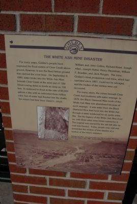
The White Ash Mine Disaster Marker
RANKED BY RELEVANCE, THEN GEOGRAPHICALLY
On 12th Street, 0.1 miles west of Maple Street, on the left when traveling west.
On Main Street (State Highway 89), on the right when traveling south.
On West Cherry Street west of South Plum Street, in the median.
On East Division Street / Johnson Road (Illinois Route 113) 1 mile west of Interstate 55, on the right when traveling west.
On West Cherry Street west of South Plum Street, in the median.
Near Main Street (Highway 80) at Dryhill Road (State Highway 257), on the right when traveling west.
On Wendover-Hurricane Creek Road, 1.4 miles south of Kentucky Highway 80, on the right when traveling south.
On U.S. 119, 2.1 miles west of Kentucky Highway 806, on the left when traveling west.
On State Highway 308, 0.1 miles west of Scotch Coulee Road, on the right when traveling west.
On U.S. 501 at Walter Bright Road, on the right when traveling south on U.S. 501.
On Millfield-Jacksonville Road (County Route 27), on the right when traveling east.
On Atwater Road (Ohio Route 183) south of Waterloo Road (U.S. 224), on the right when traveling south.
On Pennsylvania Route 56 at Lincoln Street, on the right when traveling south on State Route 56.
On Bridge Street at West Railroad Street, on the right when traveling north on Bridge Street.
Paid Advertisement
On Washburn Street at Morris Avenue, on the left when traveling west on Washburn Street.
On Sanderson Street at Charles Street, on the right when traveling south on Sanderson Street.
On West Main Street (U.S. 11) 1 miles north of South Cross Valley Expressway (Pennsylvania Route 29), on the right when traveling north. Reported damaged.
On Schoolhouse Road, 0.2 miles north of Pennsylvania Route 924.
On Union Street (Pennsylvania Route 88) 0.2 miles south of Mingo Church Road, on the right when traveling north.
On Pennsylvania Route 981 at Van Meter Road, on the right when traveling east on State Route 981.
On U.S. 6, 0.5 miles north of U.S. 191, on the right when traveling north.
On Midlothian Turnpike (U.S. 60) at Coalfield Road (Virginia Route 754), on the right when traveling east on Midlothian Turnpike.
On Coal River Road (West Virginia Route 3) just north of Bridge Avenue, on the right when traveling north.
On Stanaford Road (West Virginia Route 41) 3.8 miles Meadow Bridge Road (County Route 41), on the left when traveling south.
On West Virginia Route 16 at West Virginia Route 211, on the right when traveling west on State Route 16.
On St. Barbaras Road (County Road 19/10) south of Freedom Highway (U.S. 19), on the left when traveling south.
On Marshall Street, 0.2 miles north of 13th Street, on the right when traveling south.
On West Virginia Route 83 at Bartley Hollow Road (Local Route 83/01), on the right when traveling west on State Route 83.
Paid Advertisement
On River Road (County Route 45) at Fairmont Road (U.S. 19) on River Road.
On Morgantown Avenue (County Route 33) at East Railroad Street, on the left when traveling south on Morgantown Avenue.
On Appalachian Highway (West Virginia Route 32), in the median.
On State Highway 308, 1 mile east of South 6th Street, on the left when traveling west.
On Bonnie Street, 0.2 miles south of E. Ayer St.,.
On Maple Street at Mine Access Road, on the right when traveling north on Maple Street.
On Bridge Street (County Route 56) at Main Avenue, on the left when traveling south on Bridge Street.
On Briceville Highway (Tennessee Route 116) at Andy's Ridge Road, on the left when traveling north on Briceville Highway.
On Utica Lane north of Sam's Way, on the right when traveling north.
On Jefferson Street at Shoal Creek Avenue, on the right when traveling west on Jefferson Street.
On State Highway 308, 0.1 miles west of Scotch Coulee Road, on the right when traveling west.
On Main Street at West 8th Street when traveling south on Main Street.
On Highway 41 at Ridge Road, on the left when traveling north on Highway 41.
On West Daly Street west of A Street, on the right when traveling east.
Paid Advertisement
On West Granite Street near North Montana Street, on the right when traveling west.
On West Granite Street near North Crystal Street, on the right when traveling west.
On East Quartz Street near North Wyoming Street, on the right when traveling west.
On 2nd Street near Walnut Street, on the right when traveling west.
On West Main Street near North 2nd Street, on the right when traveling west.
On Barbour County Highway (U.S. 119) at North Main Street, on the right when traveling north on Barbour County Highway.
On East Front Street (State Highway 6 / 210) at Maple Road, on the right when traveling east on East Front Street.
On Interstate 79, on the right when traveling north.
On Bridge Street (County Route 56) at Main Avenue, on the left when traveling south on Bridge Street.
Near Allen Avenue at Philip Street.
On 7th Avenue west of 10th Street, on the left when traveling west.
On Main Street (West Virginia Route 211) 0.2 miles west of Route 16, on the left when traveling west.
On State Highway 49 (California Route 49), on the right when traveling south.
On Bridge Street (County Route 56) at Main Avenue, on the left when traveling south on Bridge Street.
Paid Advertisement
On Main Street (Kentucky Route 132) south of Hearin Street, on the right when traveling south.
On Appalachian Highway (West Virginia Route 32), in the median.
On South Beachview Drive, 2.3 miles south of Jekyll Island Causeway (Route 520), on the right when traveling south.
On East Main Street (County Route 640) at Tacoma Avenue SE on East Main Street.
On U.S. 40 at milepost 114.5 at County Highway 52, on the right when traveling east on U.S. 40.
On Coal River Road (West Virginia Route 3) just west of Bridge Avenue, on the right when traveling east.
On Main Street (U.S. 11) at Carolina Street, on the right when traveling east on Main Street.
* Inflectional forms of words are their plurals, singulars, and possessives as well as gramatical tenses and similar variations.