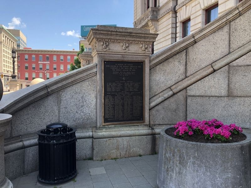
In honor of those
who served in the Spanish-American War
Company H, 2nd Mass. Inf., U. S. V.
The Wellington Rifles
Mustered into the United States
Service May 3, 1898
Mustered out Nov. 3, 1898. . . . — — Map (db m151818) WM
A few rods east stood the house and mill of John Wing built in 1684. This was the only house left standing after the breaking of the second settlement of Worcester. — — Map (db m48044) HM
On June 12, 1880, the first perfect game in professional baseball history was pitched on this site (the former Worcester Agricultural Fairgrounds) by J. Lee Richmond of Worcester against Cleveland in a National League game. — — Map (db m70961) HM
Inspired by Korean War veteran Ronald K. Johnson, the Korean War Veterans Association of Central Massachusetts was chartered in 1990 with Mr. Johnson selected as its first Commander. Under his strong leadership a small, dedicated committee was . . . — — Map (db m151842) HM
Through this place passed General Henry Knox in the winter of 1775 – 1776 to deliver to General George Washington at Cambridge the train of artillery from Fort Ticonderoga used to force the British Army to evacuate Boston. Erected by the . . . — — Map (db m17932) HM
Born in Concord August 29, 1826
Died in Worcester September 30, 1904
Lawyer • Scholar • Orator • Statesman
Citizen of Worcester
for more than half a century
member of Massachusetts House of Representatives 1852
Member of . . . — — Map (db m151815) HM
General Washington passed this spot July 2, 1775 on his journey from Philadelphia to Cambridge to take command of the Continental Army — — Map (db m187442) HM
The Blackstone River Canal generally followed the Mill Brook through Worcester, but between Kelly Square and Brosnihan Square it separated from the brook, creating a bell-shaped island that later became known as Green Island. The Blackstone River . . . — — Map (db m151753) HM
One-half mile up Malvern Road is the Indian spring and the site of the Indian village Pakachoag, clear spring, one of the three Indian villages on Worcester
ground. John Eliot preached here in 1674. — — Map (db m88496) HM
Prep. 1904-06, College 1906-08. Captain Holy Cross Baseball 1908. All-Time, All-Star, Holy Cross Shortstop. Philadelphia Athletics 1908-15. Member Connie Mack’s million dollar infield. Red Sox 1915-18. Manager Red Sox 1917. World Series . . . — — Map (db m122513) HM
On the slope of the hill one-half mile west stood the house of Jonas Rice, the first permanent dwelling in Worcester, built in 1713. He served as schoolmaster and his son, Adonijah, was the first white child born in Worcester. — — Map (db m48790) HM
On This Site
In 1713,
Major Jonas Rice
Made the First
Permanent Settlement
In Worcester.
Placed by
The Worcester Society of Antiquity — — Map (db m162465) HM
"Besides the great duty of erecting a memorial of our fallen heroes...the erection of this monument will add an ornament to the city which will make it conspicuous among the cities of the continent for its possession of such a noble work . . . — — Map (db m151776) HM
This marks the Northeast Corner of the cemetery which served the Town of Worcester from 1728 to 1824 about 225 graves with their monuments laid flat still remain within this area. — — Map (db m151778) HM
At the end of Hamilton Street is the site of the Leonardson house from which in 1695 Samuel, aged twelve, was taken captive. Two years later he was with his Indian master at the burning of Haverhill and helped Hannah Dustin to make her escape. — — Map (db m48791) HM
This marks the Southeast Corner of the cemetery which served the Town of Worcester from 1728 to 1824. About 225 graves with their monuments laid flat still remain within this area. — — Map (db m151782) HM
Honor and Fidelity
The 65th Infantry Regiment, one of the largest and best-trained in the U.S. Eighth Army, arrived in Korea on 23 September 1950. Its first mission took place on September 28, when it assaulted a strongly-defended . . . — — Map (db m151868) HM
End of an Era
Opened in 1828 to connect Worcester and Providence, the Blackstone Canal transported goods throughout the Blackstone Valley. The canal system was replaced by the faster and more efficient railroad by the 1840s. When the canal . . . — — Map (db m151752) HM
Erected by Veterans and a grateful community to honor the men and women of Worcester County who faithfully served in the Armed Forces during the Korean War
1950 - 1953
In reverence to those who hath answered our country's call, your . . . — — Map (db m151836) WM
In front of this tablet stood the first school-house in Worcester where John Adams second president of the United States taught 1755-1758
Placed by the Colonel Timothy Bigalow Chapter 1903 — — Map (db m178658) HM
As World War II began, President Franklin Delano Roosevelt described the United States as "the arsenal of democracy." Even before the attack on Pearl Harbor and the German declaration of war on the United States, the nation had been providing . . . — — Map (db m151794) HM
Born in Worcester on November 22, 1919
South High School - 1938
College of the Holy Cross - 1942
Boston College Law School - 1948
United States Marine Corps - First Lieutenant
World War II - 1942 - 1946
Korean War - 1950 - 1952 . . . — — Map (db m151811) HM WM
To the
men and women
who answered the
call and especially
those who gave
their lives
Commonwealth of Massachusetts
Honor Roll
Auger, Allen R., Corporal, USMC •
Burt, Paul L., Sergeant, USA • . . . — — Map (db m151783) WM
"We were alerted for Korea and I remember it very clearly. We would be gone a couple of weeks at the most to make a show of force, a parade in Korea, then back to Japan." — U.S. Soldier of the 34th Infantry . . . — — Map (db m151872) HM
April 1865... the Civil War was over. The war had been a life-changing event. It obliterated the normal patterns of life as men were swept into training camps and battle units. Families struggled to survive, businesses tried to cope with the loss . . . — — Map (db m151763) HM
To honor those brave sons and daughters who served and those who gave their lives for their nation under God in the struggle for peace in Vietnam
The American people acknowledge their duty and sacrifice with gratitude and pride — — Map (db m151784) WM
Formal warfare began in Europe on September 1st, 1939 with the German invasion of Poland, but there had already been fighting in Spain's civil war and in Ethiopia when Italy invaded North Africa in 1936. Furthermore, in a process called . . . — — Map (db m151806) HM
The Japanese Empire, like its European ally Germany, was determined to expand its control in East Asia by "annexing" territory and asserting control over the region. Japan took advantage of the European war to invade and seize French, Dutch, and . . . — — Map (db m151791) HM
The first settlement of this lonely region called Quinsigamond was attempted in 1673, but abandoned during King Philip's War. A second settlement, attempted in 1684, soon named Worcester, was also temporarily abandoned because of Indian hostility. . . . — — Map (db m48046) HM
The first settlement of this lonely region called Quinsigamond was attempted in 1673, but abandoned during King Philip's War. A second settlement, attempted in 1684, soon named Worcester, was also temporarily abandoned because of Indian hostility. . . . — — Map (db m48047) HM
The first settlement of this lonely region called Quinsigamond was attempted in 1673, but abandoned during King Philip's War. A second settlement, attempted in 1684, soon named Worcester, was also temporarily abandoned because of Indian hostility. . . . — — Map (db m48048) HM
On this spot stood Worcester's First City Hall where was held July 20 1854 the first convention of delegates founding the Republican Party in Massachusetts — — Map (db m151814) HM
The Second World War began when the German army, led by Nazi Führer Adolf Hitler, invaded Poland on September 1st, 1939. Germany already controlled Austria and parts of Czechoslovakia through a process called "Appeasement." In Asia, the conflict . . . — — Map (db m151809) HM
In honor of the courageous men and women of Worcester who served our country in the spirit of securing freedom, democracy, and peace for our nation and the world. May the memory of their bravery endure through the annal of time.
Presented by . . . — — Map (db m151789) WM
The President of the United states takes pride in presenting the Medal of Honor posthumously to
Lieutenant John V. Power
United States Marine Corps Reserve
for service as set forth in the following . . . — — Map (db m151822) WM
One mile north on Wigwam Hill was one of the three Indian villages on Worcester ground. The heirs of Sagamore Pennasanet sold their rights to Captains Gookin, Henchman and Prentice on December 6, 1677. — — Map (db m48045) HM
The Albion Dam on the Blackstone River has been a key feature since 1822. Originally built to harness the river's power for textile production, it now generates hydroelectric power. It is recognized as a contributing resource to the Albion . . . — — Map (db m311584) HM
Arches Everywhere
At the mill complex which once filled this park, arched openings in buildings crossed raceways and defined the [unreadable] of windows and doors. Some of the arches are intact, but many are not. The two in front of you are . . . — — Map (db m251520) HM
pre-1800's
Prehistoric and historic Indian peoples, and English colonists, fished at Valley Falls leaving few traces.
1812 - 1820
Twin brothers Abraham and Isaac Wilkinson bought land and water rights on both sides of the river . . . — — Map (db m313314) HM
This bell was cast by George Holbrook in East Medway MA in 1840, and was installed at 22 Broad St. It remained there until 1977 when it was dismantled by the Knights of Columbus and brought to the Hayden Library and dedicated to the departed . . . — — Map (db m55663) HM
Na honrosa visita de sua excelência o Presidente da Republica Portuguesa Dr. Mario Soares, o Clube J. Lusitana Agredecido 24-5-87
[English translation:]
Commemorating the visit of His Excellency Dr. Mario Soares, . . . — — Map (db m251526) HM
A Cultural Context
The Valley Falls mill was once once of several industrial centers in the community. The mill here ran for over a hundred years until 1834, and [unreadable] Valley Falls the political center of Cumberland. The distinctive . . . — — Map (db m251501) HM
The house of Samuel B. Chase and Elizabeth Buffum Chase, once located across the street, played an important role in the antislavery movement of the 1840s and 1850s. As a secret refuge for fleeing slaves, this home was a stop on the "underground . . . — — Map (db m251489) HM
Hydraulic turbines are water motors that turn at great speed. The metal turbines at this site used the pressure of water (created by the [unreadable] dam) to generate power. They [unreadable], more efficient, and more durable than wooden water . . . — — Map (db m251522) HM
Dedicated by a grateful community in memory of all veterans who have championed the cause of freedom through service in the United States Armed Forces — — Map (db m251491) WM
Dedicated to the Glory of Almighty God in memory of Cumberland men and women who by their unselfish patriotism have advanced the American ideals of liberty and the universal brotherhood of man.
Servant of God well done.
Well . . . — — Map (db m251494) WM
The force of falling water can turn wheels and other devices to power machinery. Capturing that force requires a dam to divert water's natural path, artificial channels or raceways to lead water through a power-creating wheel, and a tailrace . . . — — Map (db m251519) HM
Your Key to the Past
On this Spot
The site of the brick storehouse, mentioned on the sign at the Broad Street park entrance is immediately to your left. There was a small addition to the storehouse right behind you. The bridge in front . . . — — Map (db m251517) HM
The Mercantile Center
The two brick and stone buildings in front of you played an important role in the planned mill village of Slatersville. Known as the Commercial Blocks they were built by the Slater Company for the use of their workers. . . . — — Map (db m197767) HM
James Slater Memorial Park In Honor of James S. Slater Born Apr.23, 1841 Died Nov. 11, 1915 Town Clerk No Smithfield 1903-1914 General Assembly 1914-1915
To whom the State of Rhode Island and Providence Plantations owes recognition for the . . . — — Map (db m197766) HM
Dedicated in Honor of
The patriotic Men and Women of the
Town of North Smithfield
Who Served Their Country in Time of War
Vietnam Era
★Leon Atterbridge · ★Rene Bois · ★Frederick Carter · ★Robert Labrecque · . . . — — Map (db m197769) WM
Vietnam War Memorial
From the people of
The town of North Smithfield
In recognition of those who defended
Freedom during the Vietnam War
and to those Men and Women
who sacrificed their lives that we may
live in Freedom and . . . — — Map (db m192605) WM
For about one hundred and fifty years, workers crossed this church common most mornings on their way to the mill. Six days a week, they returned to their homes throughout Slatersville at dusk, likely weary from hours of repetitive work. . . . — — Map (db m311589) HM
Just six years after building Slater Mill, Samuel Slater's partners, William Almy and Obadiah Brown, bought another mill on their own. They even copied some of Slater's machine designs for their mill.
This annoyed Slater so much that he . . . — — Map (db m151663) HM
Tradition holds that Ebenezer Jenks built the house in front of you in the mid-1700s. He was the grandson of Pawtucket's first settler, Joseph Jenks, Jr.
By the end of the 1700s, Sylvanus Brown, a mechanic owned the place. He welcomed Samuel . . . — — Map (db m151660) HM
Samuel Slater came here from England in 1789. He had just finished a seven-year apprenticeship at an English cotton mill, which gave him great knowledge of the water-powered spinning process developed over the previous two decades.
With the . . . — — Map (db m151668) HM
Built in 1685, this is the oldest standing house in Pawtucket and is on the National Register of Historic Places. It is now operated by the Pawtucket Chapter of the Daughters of the American Revolution.
For tour Hours Contact the Park Office — — Map (db m45087) HM
In commemoration of the 150th anniversary of the first successful cotton mill in America this tablet was presented to the Old Slater Mill Association, present owners of this historic building in honor of the textile pioneer whose name they . . . — — Map (db m1613) HM
Control of waterpower meant control of economic, political, and social power.
A mill developer's first "power grab" was to build a walled dam. This created a pond that stored water to power the mill.
Other villagers didn't willingly . . . — — Map (db m151665) HM
First Rhode Island woman to make the supreme sacrifice as an Army Nurse with the Armed Forces of the United States in France during the World War
"She laid him with the dead as she turned to soothe the living and bind the wounds . . . — — Map (db m151678) WM
1885-1918
During his flying career, Jack McGee, one of Pawtucket's most famous sons and a pioneer in this country's aviation history, used this general area of Darlington to make many of his historic flights.
On June 11th 1918 he was killed . . . — — Map (db m45089) HM
This is the oldest stander carousel in the world it was built by pioneer craftsman Charles I. D. Looff in 1895, and was installed in Slater park in 1910.
Open weekends April, May, June, September, October and daily in July and August. Available . . . — — Map (db m45091) HM
David Wilkinson and his father built this mill together, finishing it in 1811. It made sense to build it next to Slater Mill. When Slater married Wilkinson's sister, Hannah, the families grew even closer and shared several ventures.
At . . . — — Map (db m151661) HM
Samuel Slater (1768-1835) opened this water-powered cotton spinning factory in 1793. Slater had left England in 1789 with working knowledge of mechanical yarn-making, and in Pawtucket he discovered artisans with the skills necessary for starting . . . — — Map (db m118316) HM
The American Industrial Revolution began right here. In 1793, Samuel Slater teamed up with investors and local artisans. Together, they built a first for the United States—a successful cotton spinning mill that was run by water power. . . . — — Map (db m151657) HM
This building is a contributing structure of the
Downtown Pawtucket
Historic District
in the
National Register of Historic Places
United States Department of the Interior
The Deborah Cook Sayles . . . — — Map (db m151674) HM
This building is a contributing structure of the
Downtown Pawtucket
Historic District
in the
National Register of Historic Places
United States Department of the Interior
[Top plaque:]
The . . . — — Map (db m151672) HM
Honor to our gallant men and women
who served their nation
in the military during times of peril
They gave their yesterdays
in order to insure our tomorrows
Lest we forget
A grateful community
wishes to acknowledge all . . . — — Map (db m151653) WM
In 1900 the Redmond family moved to Pawtucket from Fall River. Lawrence soon found employment with the Western Union Telegraph Company. Later he worked for the postal telegraph system. He enlisted in the Rhode Island National Guard, Coast . . . — — Map (db m251488) HM WM
Slater Mill was America's first successful water-powered cotton spinning mill. For a small fee, tour the mill and learn how Samuel Slater and local craftsmen created machines that spun cotton into thread. Explore the Wilkinson machine shop and see a . . . — — Map (db m151659) HM
The American Industrial Revolution began at Slater Mill. Here, in 1793, Samuel Slater, with Providence investors and Pawtucket artisans, built the first water-powered, cotton spinning factory in the United States. Beginning with this wooden mill, . . . — — Map (db m118324) HM
To perpetuate the memory of all who with unfailing loyalty defended on land and sea the nation's honor in the War with Spain, Phillipine Insurrection and China Relief Expedition. — — Map (db m151652) WM
Sylvanus Brown lived in this cottage from 1784 to 1824. Brown's proven pattern-making and carpentry skills earned him a place at Samuel Slater's side. Brown had also built water-powered mills and visited European mill sites. Between 1789 and . . . — — Map (db m118327) HM
At this corner once stood the Leroy Theatre. Named after the son of the first owner Charles T. Payne's who died in World War I, this Art Deco theatre opened in 1923, and it operated as a cinema, concert venue, and later a live boxing and . . . — — Map (db m251462) HM
The birthplace of the cotton manufacturing industry in America. Here in 1793 Samuel Slater, Moses Brown, and William Almy established the first successful cotton factory in the United States. — — Map (db m1612) HM
When Samuel Slater first came here, the village had everything he needed to succeed. Pawtucket Falls provided ample waterpower. That energy was already powering local machine shops. Those shops were run by skilled mechanics who could assist with . . . — — Map (db m151670) HM
David Wilkinson (1771-1852), a blacksmith from Smithfield, Rhode Island, moved to Pawtucket in the early 1780s. Wilkinson invented new machines, including a steamboat, which he demonstrated in Pawtucket in 1792 (15 years before Robert Fulton's . . . — — Map (db m118248) HM
Why Is The Sculpture Here?
This sculpture, titled "Tolerance," is an artistic resemblance of the Reverend William Blackstone, an English minister who made a home several miles from here. His name is now attached to many . . . — — Map (db m251479) HM
Dedicated to
the memory of all
the members of the
Major
Walter G.
Gatchell
VFW Post 306
and its Auxiliary
Past Present & Future
Founded
1920
Auxiliary
1921
[Left side of the memorial:] . . . — — Map (db m151651) WM
The water flowing through the millrace below you was brought here to do work. It was diverted from the Blackstone River on your right and will flow back into it downstream. Wilkinson Mill, the stone building on your left, shared this raceway with . . . — — Map (db m151667) HM
Controlling water power during the early years of the Industrial Revolution also meant gaining control of political, economic, and social power. Re-engineering water courses in this area often brought lawsuits and anger. In August 1792, four . . . — — Map (db m118317) HM
Morris Brown House
has been placed on the
National Register
of Historic Places
by the United States
Department of the Interior
Built 1793 — — Map (db m151679) HM
The Brown Bear was introduced in 1904 as the athletic mascot and symbol of the College. Throughout the decades, the Bear has been represented in verse, song, and image, as well as by live bears named Bruno, costumed students, and campus statuary. . . . — — Map (db m151684) HM
Has been designated a Registered National Historic Landmark
Under the provisions of the Historic Sites Act of August 21, 1935
This site possesses exceptional value in commemorating and illustrating the history of the United States
US . . . — — Map (db m56155) HM
This edifice of which the older portion was begun in the year of Our Lord 1760 and first occupied in 1762 was used as Court and State House by the Colony and State of Rhode Island and Providence Plantations until the year 1900 — — Map (db m56158) HM
Fleur-De-Lys Studio
Has been designated a National Historic Landmark
This building possesses National Significance in Commemorating the History of the United States of America
1992
National Park Services
United States Department of the . . . — — Map (db m57749) HM
Beginning as a free mission in 1795, members met in the African Meeting House before purchasing this lot in 1820. The services were held in the homes of the members for over 40 years. In 1866, the church was built on Meeting Street and served for . . . — — Map (db m30314) HM