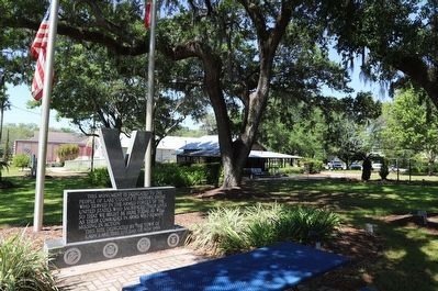
This monument is dedicated to the people of Lake County. It honors those who served in the Armed Forces of the United States who sacrificed their lives so that we might be here today. As well as their comrades in arms, who remain missing in . . . — — Map (db m219525) WM
Near Paige Place 0.1 miles west of Main Street, on the right when traveling west.
(top)
Dedicated to the recipients of this nations oldest military decoration “The Purple Heart"
(front)
Combat Wounded Veterans
My stone is red for
the blood they shed
The medal I bear
is ny country’s way
to . . . — — Map (db m248017) WM
On Paige Place 0.1 miles west of Main Street, on the right when traveling west.
Veterans’ Memorial Park
Dedicated to Veterans - Past and Present
The Veterans’ Memorial Park in the Villages was designed to pay tribute to the many men and women who have served their country and provided us with the most precious . . . — — Map (db m248072) WM
Near West Meadow Street at North 6th Street, on the left when traveling east.
Battlefield Cross
When a serviceman or woman is lost
in the battlefield, it has become customary
to arrange their boots, rifle and helmet
and the surviving members of their squad
will gather around and memorialize their . . . — — Map (db m246707) WM
Near West Meadow Street at North 6th Street, on the left.
F. Brown Gregg
Captain in the U.S. Army Air Corps in World War II
Pilot in the 9th Air Force, 387 Bomb Group & 558 Bomb Squadron
Awarded the Silver Star and Air Medal with 6 Oak Leaf Clusters
for his 37 successful . . . — — Map (db m246855) HM WM
Near Orange Avenue at West Line Street, on the right when traveling north.
Korea
“The Forgotten War”
June 25, 1950 — July 27, 1953
Killed in Action 36,574
Wounded in Action 103,284
Missing in Action 8,025
In honor and remembrance of
those who served and sacrificed to
promote freedom for all. . . . — — Map (db m257893) WM
Near Orange Avenue at West Line Street, on the right when traveling north.
Captain Albert D. Wright
Eustis
Captain Wright entered the Union Army on August 15, 1862, where he was mustered in as a sergeant in Company A, 149th Pennsylvania Volunteer Infantry. On April 20, 1864 he was transferred to the 43rd United . . . — — Map (db m247085) HM WM
On Orange Avenue at West Line Street, on the right when traveling north on Orange Avenue.
Army Nurses
On December 7, 1941 there were fewer than 1000 Army nurses and of those 82 were in Hawaii. They were serving at the three hospitals and they were overwhelmed with hundreds of causalities suffering from severe burns and shock. . . . — — Map (db m246704) HM WM
On Orange Avenue at West Line Street, on the right when traveling north on Orange Avenue.
In Honor & Memory Of Those
Who Served In The
Vietnam War
KIA 58,209 - WIA 153,303
Welcome Home
Veterans
Duty ★ Honor ★ Country
Duane I Haverstock • James M Fierce • Michael T McCourt • Charles R Harold • Paul . . . — — Map (db m253668) WM
On Orange Avenue at West Line Street, on the right when traveling north on Orange Avenue.
WAVES
Women Accepted for Volunteer Emergency Service
The woman’s branch of the United States Navy was established on 30 July 1942 by President Roosevelt this authorized the U.S. Navy to accept women into . . . — — Map (db m246677) HM WM
On Orange Avenue at West Line Street, on the right when traveling north on Orange Avenue.
Women Marines
United States Marine Corps Women’s Reserve
The qualifications for women who wished to become members of the “WR” (Women’s Reserve) were quite rigid. United States citizenship: not married to a Marine: either single or . . . — — Map (db m247083) WM
Near Orange Avenue at West Meadow Street, on the right when traveling north.
(Panel 1)
December 7, 1941 - Japan Attacks Pearl Harbor, Hawaii
2,403 Died - 1,176 Wounded
The Battle of Pearl Harbor began on December 7, 1941 when the Imperial Japanese Navy Air Service led a surprise military strike on Pearl . . . — — Map (db m256226) HM WM
On East Porter Avenue at 2nd Street, on the right when traveling east on East Porter Avenue.
Built in the late 1870s, this house is the oldest building in Montverde. Pioneer merchant and citrus grower Reuben Wyatt Harper purchased it in 1891 after moving to Lake County from Alabama. At first, Harper ran a store and the town's first post . . . — — Map (db m136021) HM
On 7th Street (County Road 455) south of Porter Avenue, on the right when traveling south.
Montverde Academy was founded by Hermon Palestine Carpenter in 1912 as the Montverde Industrial School for students of limited means. A native of Boyle County, Kentucky, Carpenter (1877-1958) came to Florida in 1912 and decided to found a school at . . . — — Map (db m93362) HM
Near 6th Street north of Porter Avenue, on the right when traveling north.
Dedicated to those who served our Nation.
(emblems) United State Army • United States Navy • United States Air Force • United States Marine Corps • United States Coast Guard — — Map (db m212339) WM
Near North Donnelly Street at East 5th Avenue, on the right when traveling north.
In the fall of 1924, J. P. Donnelly, persuaded by the Mount Dora Woman's Club, agreed to sell to the City what is now Annie Donnelly Park for the sum of $45,000. On October 12 of that year, the City accepted the property and authorized the issuance . . . — — Map (db m261164) HM
On Alexander Street south of West 4th Avenue, on the right when traveling south.
The first railway line was opened in Mount Dora in 1887 by the Jacksonville, Tampa and Key West
Railway (JT&KW) The 29.5 mile branch ran from Sanford to Tavares with a morning and evening stop at the Mount Dora Depot. In 1902, the Atlantic Coast . . . — — Map (db m80600) HM
On North Donnelly Street north of East 4th Avenue, on the right when traveling north.
This building was constructed for the Bank of Mount Dora in 1925 after it was given a separate charter and authority to operate as a bank. Originally, it was a branch of the Citizens Bank of Eustis and was founded on September 5, 1913. The bank . . . — — Map (db m287515) HM
On West 4th Avenue at North Donnelly Street, on the right when traveling west on West 4th Avenue.
J.P. Donnelly
John Phillip was born in Allegheny, Pennsylvania on February 5, 1850. J.P moved to Mount Dora in 1879 where he invested heavily in the community and established several citrus groves.
Shortly thereafter, J.P. Donnelly . . . — — Map (db m287658) HM
On North Donnelly Street 0.1 miles south of East 5th Avenue, on the right when traveling south.
As one of the oldest buildings in downtown Mount Dora, this two-story, molded block building was constructed in 1909 and is one of the least altered buildings. Dr. T.N. Lewis' drugstore was located in the two-story section and the post office . . . — — Map (db m287445) HM
On Royellou 0.1 miles south of Royellou Lane, on the left when traveling south.
Mount Dora's first firehouse was built in 1923 on property donated by John P. Donnelly. Soon after, five single jail cells were added to the East side of the building. In 1941, the fire department moved to a larger location, but the jail stayed and . . . — — Map (db m287725) HM
On West 5th Avenue at North Donnelly Street, on the right when traveling west on West 5th Avenue.
James Simpson built the Mount Dora Bank building in 1926 and was its first president. In 1927, the bank converted to a national bank and became known as the First National Bank of Mount Dora. The interior of the Georgian-style bank building featured . . . — — Map (db m287520) HM
On North Donnelly Street north of East Fifth Avenue, on the left when traveling north.
John P. Donnelly, a native of Pittsburg, came to Mount Dora in 1879. In 1881, he married Annie McDonald Stone, a prominent landholder in the community. Successful in a number of real estate and business ventures, Donnelly built this imposing Queen . . . — — Map (db m72779) HM
On North Donnelly Street south of East 5th Avenue, on the right when traveling south.
Although remodeled to appear as one building today, originally this structure was two separate buildings. The one-story structure on the north was the temporary building for the Mount Dora Bank & Trust Co. The two-story building was a garage built . . . — — Map (db m287574) HM
On East 5th Avenue at North Donnelly Street, on the right when traveling east on East 5th Avenue.
This Mediterranean Revival style building was constructed in 1925. It is particularly notable for its unique architecture. The building's first known occupant was the Lakes on Hills Realty Company, operated by Samuel Sadler and Jack Simpson. Mount . . . — — Map (db m287702) HM
On North Donnelly Street just north of East 6th Avenue, on the right when traveling north.
Built in 1925, this bungalow was the home of Margaret Lewis, one of the first teachers at Educational Hall. She was a civic leader who was involved with the Woman's Club, the International Order of King's Daughters and the Congregational Church. . . . — — Map (db m311976) HM
On Alexander Street just south of West 4th Avenue, on the left when traveling north.
This courageous journalist exposed rampant corruption and racism among Lake County's leading law enforcement and judicial officials during the Jim Crow era of the 1950s. Her groundbreaking coverage revealed widespread cases of planted evidence, . . . — — Map (db m261097) HM
On North Highland Street at East Jackson Avenue on North Highland Street.
Milner-Rosenwald Academy served African-American school children from 1926 to 1962. When fire destroyed the old school in 1922, parents and community leaders, led by Mamie Lee Gilbert (1886-1976) and Lula Butler, raised money for a new one. Seed . . . — — Map (db m72753) HM
On North Donnelly Street at East 5th Avenue, on the right when traveling north on North Donnelly Street.
This building was constructed circa 1919 by Monroe V. and Martha Simpson for their grocery business. It is one of the downtown districts oldest buildings. Monroe managed the grocery store while Martha managed the dry goods store next door, and they . . . — — Map (db m288065) HM
On North Donnelly Street north of East 4th Avenue, on the left when traveling north.
Monroe Patterson, who operated a pottery and china business in East Liverpool, Ohio, built the Mount Dora Hotel in 1924. The building was constructed by local builder A.J. Waltz, who used hollow terracotta Egyptian block to construct the hotel. The . . . — — Map (db m287420) HM
On West 4th Avenue at North Donnelly Street, on the right when traveling west on West 4th Avenue.
Dora Ann Drawdy
Dora Ann Fletcher was born on May 12, 1826 in Irwin, Georgia. Dora married her husband James Drawdy in 1843 and had three children. Tragically, James died shortly after the birth of their last child Martha Ann in 1848. A . . . — — Map (db m288064) HM
On North Donnelly Street north of East 4th Avenue, on the right when traveling north.
John P. Donnelly constructed this building following the fire of 1922. The Mount Dora Topic & Publishing Company occupied this building for nearly 40 years with multiple owners. The most notable was Mabel Norris Reese, owner, editor, and . . . — — Map (db m287439) HM
On West 5th Avenue at North Donnelly Avenue, on the right when traveling east on West 5th Avenue.
James Simpson constructed this building in 1922 for the town theatre. Prior to this time, movies were shown in the Town Hall located on Donnelly Street. At the time of its construction, the building had a simpler facade. In the late 1920s, the . . . — — Map (db m287705) HM
On Royellou Lane at East 5th Avenue, on the left when traveling south on Royellou Lane.
Al Rehbaum and Fletcher Crane built this warehouse circa 1920s to store hardware, coffins, and furniture for the Rehbaum Hardware store, Rehbaum funeral parlor, and the Rehbaum & Crane Furniture store. This warehouse was used by Rehbaum Hardware, . . . — — Map (db m287452) HM
On North Donnelly Street at East 4th Avenue, on the right when traveling north on North Donnelly Street.
Alfred Rehbaum, Sr. arrived in Mount Dora in 1915 from Ancona, Florida. He managed the Mount Dora Hardware store, which later became known as Rehbaum Hardware, in the north half of the building, and the M.O. Williams drugstore and pharmacy occupied . . . — — Map (db m287447) HM
On 4th Avenue at Alexander Street, on the left when traveling west on 4th Avenue.
This Sears, Roebuck & Co. "kit home" was built by Charles Edgerton in 1922 in keeping with his obligation to the Mount Dora Improvement Society. From 1908 to 1940, Sears sold around 75,000 kit homes to middle-class families hoping to realize their . . . — — Map (db m288012) HM
On East 9th Avenue at North Tremain Street, on the left when traveling east on East 9th Avenue.
For many years, until removed in November of 1991, this corner in Mount Dora was the site of the city water tower. The fire department had a large whistle on the tower to advise volunteers of fires. The number of times it sounded indicated where . . . — — Map (db m312248) HM
On West 5th Avenue at North Donnelly Street, on the left when traveling west on West 5th Avenue.
In 1925, James Simpson built the Simpson Hotel as Mount Dora's first fireproof hotel. As part of the fireproofing, concrete, steel, and red brick were used in the building's construction. The electrical wiring was encased in water pipes with a . . . — — Map (db m287564) HM
On Charles Avenue at South Terminal Street, on the right when traveling east on Charles Avenue.
In 1948, The Icehouse Players came into being when a handful of determined folks volunteered six months of sweat equity to renovate the former Mount Dora Ice Company at 120 Charles Avenue into a community theater. The original footprint was . . . — — Map (db m155859) HM
On West 4th Avenue at Dora Drawdy Way, on the right when traveling west on West 4th Avenue.
In the wood-framed portion of this building, Charles Stowe, who arrived in Mount Dora in 1884, operated a general store until the Great Freeze of 1894-95, when he became discouraged and sold it to his employee, Russell True. It changed hands many . . . — — Map (db m287919) HM
On West 4th Avenue at Alexander Street, on the right when traveling east on West 4th Avenue.
Stanton McClellan Child was born in Wisconsin in 1863 and moved to New York at the age of 17 to work as a pattern maker (iron casting) with his father and brother. By 1901, he had worked his way up to become a wealthy New York industrial engineer . . . — — Map (db m261098) HM
On North Donnelly Street at East 4th Avenue, on the right when traveling north on North Donnelly Street.
As automobiles became more prevalent in Mount Dora. J.M. Smith opened a service station in the mid-1920s. In 1945, Harold Larson, Shelby Caudel and Robert Caudel relocated their Texaco Service Station and Florida Motor Line Bus Station to this . . . — — Map (db m287641) HM
On North Donnelly Street at East 7th Avenue, on the right when traveling north on North Donnelly Street.
The First Congregational Church of Mount Dora was established in 1883, and Ross Tremain was its first deacon. The land on which the church was built was donated by John and Annie Donnelly, and the building was occupied in 1886. At that time it . . . — — Map (db m311995) HM
On North Baker Street at East 3rd Avenue, on the right when traveling north on North Baker Street.
Alfred Rehbaum, Sr., came to Mount Dora in 1915 from Cincinnati, Ohio. Rehbaum was 20 in 1915 when he was hired by J.P. Donnelly to mange Donnelly's hardware store. Rehbaum later bought the business and renamed it Rehbaum's Hardware from the Mount . . . — — Map (db m182171) HM
On North Donnelly Street at West 4th Avenue, on the right when traveling south on North Donnelly Street.
This circa 1938 building is one of the younger buildings in the downtown district and is significant for its modern architectural styling. The Drugg Variety Store, owned by Henry and son Proctor Drugg, was the first business located here. By 1943, . . . — — Map (db m287927) HM
On County Road 19A at Dodson Cutoff, on the right when traveling south on County Road 19A.
This memorial is dedicated to all veterans
Let us not forget the sacrifices they
and their families made to protect
and defend our freedoms — — Map (db m221118) WM
On East 5th Avenue at North Baker Street, on the right when traveling west on East 5th Avenue.
Dedicated to Walter D. Patton Department Commander of Florida United Spanish War Veterans 1942 • 1943 by Department Auxiliary U.S.W.V. May 9, 1943 — — Map (db m261170) WM
On North Donnelly Street at West 4th Avenue, on the right when traveling south on North Donnelly Street.
This brick house (on the left) was built by Warren C. Butts as an advertisement for his brick and cement business. The original home, with an addition and modifications, is still visible both inside and outside. Mr. Butts also built an unusual house . . . — — Map (db m287926) HM
On North Clayton Street at Grant Avenue on North Clayton Street.
The Witherspoon Lodge of Free and Accepted Masons, No. 111, is one of Florida’s oldest functioning African American lodges. Established in 1898, it followed the tradition of Prince Hall (1735-1807), who opposed racial oppression in Colonial New . . . — — Map (db m72772) HM
Lakeside Inn Est. 1883
was placed on the
National Register
of Historic Places
by the United States
Department of the Interior
on March 19, 1987 — — Map (db m145381) HM
On Lake Dora, at the turn of the 19th century, an alligator named Old Joe could be seen cruising these waters. Captains of the paddle wheel boats would point out Old Joe, the largest, fiercest and most respected alligator on the lake. It was said . . . — — Map (db m145521) HM
On Alexander Street south of West 5th Street, on the left when traveling south.
The area received its first post office in 1880. Ross C. Tremarin was appointed as the first postmaster and named the lakeside outpost “Royellou” after his three children, Roy, Ella and Louis. Two years later, the town’s official name . . . — — Map (db m145363) HM
On Edgerton Court south of Charles Avenue, on the left when traveling south.
The Mount Dora Lawn Bowling Club was envisioned in 1925 by Willard Bryant and Fred Thompson, two winter visitors from Hartford, Connecticut. They approached Charles Edgerton, owner of the historic Lakeside Inn and member of the City’s Park . . . — — Map (db m145383) HM
On North Baker Street at East 5th Street, on the left when traveling north on North Baker Street.
In reverent memory of
the men of Mount Dora
who gave their lives in
The World War
Erected by
Mount Dora Post
American Legion
July 4, 1931 — — Map (db m143759) WM
On North Baker Street at East 6th Avenue, on the left when traveling south on North Baker Street.
After a fire destroyed the community’s Town Hall in 1922, Mount Dora was in need of an auditorium for public assemblies. Despite the hard economic times, construction of the Mount Dora Community Building began in 1929 with funds raised by the . . . — — Map (db m145589) HM
On Virgil Hawkins Circle at County Road 470 on Virgil Hawkins Circle.
Attorney Virgil Darnell Hawkins
1906-1988
Florida and Okahumpka’s
Civil Rights Pioneer
May his personal sacrifices
which desegregated
Florida's universities
and provided legal assistance
to those in need,
inspire future . . . — — Map (db m81480) HM
On 27908 Virgil Hawkins Circle 0.1 miles south of North Quarters Raod, on the right when traveling south.
Julius Rosenwald was the chairman of Sears Roebuck and Co. in 1908. As a Jewish American, he believed the most serious problem of the United Stats was the plight of Black Americans. Rosenwald was a close friend of Booker T. Washington. . . . — — Map (db m185785) HM
Near Forest Road 536 0.1 miles north of Lake King Road (Road 42), on the right when traveling north.
On October 29, 1966, Jim Kern, founder of the Florida Trail Association, and like-minded hiking enthusiasts began building the Florida Trail at the entrance to Clearwater Lake Recreation Area in the Ocala National Forest. The first 26-mile section, . . . — — Map (db m101445) HM
Near County Road 42 2 miles east of County Road 439, on the left when traveling east.
Charles and Henrietta Call were the grandparents of Walt Disney. The Call and Disney family moved to Florida in 1884 from Kansas. The families settled on land about a mile north of Paisley. Charles and Henrietta's daughter, Flora married Elias . . . — — Map (db m290977) HM
Near State Highway 19 3.3 miles north of County Road 42, on the left when traveling north.
This structure was built by the Civilian Conservation Corps (CCC) in 1938. It originally served as a home for the State Game Officer for the Ocala National Forest. It has been used by the Forest Service as an office and laboratory. The interior of . . . — — Map (db m167892) HM
On Wekiva River Road 0.1 miles south of Chipola Trail, on the left when traveling south.
The first settlers in Florida were Paleo-Indians who arrived about 14,000 years ago. These hunters and gatherers built their settlements near springs. At least a dozen campsites have been documented along the Wekiva River and Rock Springs Run.
. . . — — Map (db m265284) HM
On Wekiva River Road 0.1 miles south of Chipola Trail, on the left when traveling south.
The single room schoolhouse sat close to Ethel Road and the railway line. It also served as the church where services were held every other Sunday. The earliest mention of the school is in a deed granting half an acre of land to the School Board of . . . — — Map (db m265302) HM
Near Wekiva River Road 0.1 miles south of Chipola Trail, on the left when traveling south.
The first settlers were the Moore family: William, Charlotte, and their three sons, who came from Georgia in the late 1860s. They had 360 acres of land, but life was hard, and their three sons, who came from Georgia in the late 1860s. They had 360 . . . — — Map (db m265255) HM
On Wekiva River Road 0.1 miles south of Chipola Trail, on the left when traveling south.
Settlers would often fashion their own furniture from wood and as families grew, cabins would be extended or replaced with a bigger structure. Cooking was done outside, as indoor cast-iron stoves were too expensive for most families to afford. . . . — — Map (db m265386) HM
Near Wekiva River Road 0.1 miles Chipola Trail, on the left when traveling south.
Most cabins had one bed for the parents and two youngest children, while the rest of the family often slept on a rug on the floor. Mattresses and pillows were stuffed with grass and Spanish moss.
The mother would have a 'good' dress for church . . . — — Map (db m265345) HM
On Wekiva River Road 0.1 miles south of Chipola Trail, on the left when traveling south.
The early settler's diet consisted largely of pork, beef, fish, game, grits, sweet potatoes, butter, a little milk, and syrup. Flour could be bought at the local store, but ground, dried acorns were added to make it go further. Sweet potatoes would . . . — — Map (db m265352) HM
On Wekiva River Road 0.1 miles south of Chipola Trail, on the right when traveling south.
William S. Delk was the largest plantation owner in the area and grew cotton, rice, sugar cane and corn around Rock Springs. His first home, a log cabin, burned down when he tried to smoke out fleas with fire. The next house was built on the . . . — — Map (db m265278) HM
Near Wekiva River Road 0.1 miles south of Chipola Trail, on the left when traveling south.
In 1880, Frazier, Delk and James Madison were appointed Orange County Special Road Commissioners. They were tasked with building a public road from Orlando to Rock Springs, and another from Rock Springs to Hawkinsville, a cypress timber settlement . . . — — Map (db m265401) HM
Near Wekiva River Road 0.1 miles Chipola Trail, on the left when traveling south.
Anthony Frazier was born in Georgia in the mid-1820's and spent most of his early life as a slave on the Delk Plantation at Rock Springs. After being freed by Delk, Frazier and Robards made their way to South Carolina and enlisted in the Union Army, . . . — — Map (db m265315) HM WM
The railway transformed Ethel and other communities in the area. Before, travel was a slow and tedious experience. There were no paved roads; instead, narrow, sandy, pot-holed tracks caused ox-drawn carts to get stuck or lose a wheel. With the new . . . — — Map (db m265305) HM
Near Wekiva River Road 0.1 miles south of Chipola Trail, on the left when traveling south.
While hiking at Rock Springs in 2008, Tony Moore, a retired land surveyor and park volunteer, noticed something in the corner of a field of waist-high grass. Imagine his surprise when he discovered a tombstone with the same last name as his. He . . . — — Map (db m265310) HM
On Wekiva River Road 0.1 miles south of Chipola Trail, on the left when traveling south.
Establishing Ethel
The first settler at Rock Springs was William S. Delk, descended from English colonists who landed at Jamestown in 1623. Aged 38, he purchased 3,000 acres of land in 1854 and built a home close to the springs at what is . . . — — Map (db m265292) HM WM
On North Joanna Avenue at West Alfred Street (Old County Route 441), on the left when traveling north on North Joanna Avenue.
Built in 1923, this church on North Joanna Avenue has served Tavares as a
sanctuary for over a century. Early Methodist services in Tavares were
held in St. Clair-Abrams Hall, built in 1882 by Major Alexander St. Clair-Abrams,
the city founder. . . . — — Map (db m304175) HM
On West Main Street just east of South Sinclair Avenue, on the right when traveling east.
In July 1949, Walter Irvin, Samuel Shepherd, Charles Greenlee and Ernest Thomas — known collectively as the "Groveland Four" — were accused of crimes in Lake County. Eyewitness accounts, records, and subsequent investigations revealed that these men . . . — — Map (db m145768) HM
On South Central Avenue (State Road 19) at Golden Gem Drive, on the right when traveling north on South Central Avenue.
During the Second Seminole War (1835-1842), troops under the command of Brig. Gen. Abraham Eustis left Volusia County headed toward the Withlacoochee River as part of a military action in response to the December 28, 1835 massacre of Major Francis . . . — — Map (db m56224) HM
On Northwest 144th Avenue at Northwest 178th Avenue, on the left when traveling west on Northwest 144th Avenue.
Basinger, on the Okeechobee side of the Kissimmee River, was the beginning of present-day Okeechobee County. The first non-native settlers moved to the Basinger area after the Civil War. Many of the pioneers who moved to the area during the 1870s . . . — — Map (db m145854) HM
Near NW Park Street at SW 6th Avenue, on the right when traveling east.
The Legacy of the
Altobello Family
To Okeechobee County
Frank Altobello was born in New York City and grew up in the Bronx. At the age of 19 he enlisted in the U.S. Army during World War II. He was deployed to the South Pacific where he . . . — — Map (db m268732) HM
On Southeast 38th Avenue 0.2 miles north of U.S. 98/441, on the right when traveling north.
In these woods on Christmas Day 1837, was fought the Battle of Okeechobee, in which a large band of Seminole Indians, under Chief Wild Cat, Alligator, and Sam Jones was routed by a brigade led by Colonel Zachary Taylor, consisting of the First, . . . — — Map (db m97075) HM WM
Near SW Park Street at SW 6th Avenue, on the right when traveling east.
Branding livestock, especially cattle, has been a tradition for thousands of years. It is a technique for marking livestock so as to identify the owner. Before the widespread use of fences in large cattle ranches, cattle from neighboring ranches . . . — — Map (db m268654) HM
Near SW Park Street at SW 6th Avenue, on the right when traveling east.
A cutting horse is a stock horse, typically an American Quarter Horse, bred and trained for cutting.The term "cutting" in ranch terminology is the ability of a horse and rider to separate a single cow from a herd of cattle and prevent it from a herd . . . — — Map (db m268662) HM
On Northwest 2nd Street at Northwest 2nd Avenue, on the right when traveling west on Northwest 2nd Street.
In May 1915, Reverend William Troutman and seven founders established the First United Methodist Church (Methodist Episcopal Church South). The first church building was completed in 1916 on land donated by the Okeechobee Company, a Henry Flagler . . . — — Map (db m128659) HM
On NW Park Street at SW 6th Avenue, on the right when traveling east on NW Park Street.
Florida cattle producers care deeply about their animals and their land, and it's not just because the livestock and fields are tied to their livelihoods. Many ranches in the Sunshine State are family owned, and ranchers live on the land with their . . . — — Map (db m268658) HM
Near 5SW Park Street at SW 6th Avenue, on the right when traveling east.
In 1521, Juan Ponce De Leon brought a small herd of Andalusian cattle and horses with him on his second expedition to the New World. These were the first cattle and horses to ever set foot (or hoof) on what is now the continental United States. The . . . — — Map (db m268586) HM
Near SW Park Street at SW 6th Avenue, on the right when traveling east.
For centuries, the Seminole Tribe in Florida have been experp cattlemen and an important part of the Florida cattle ranching history and industry.
The first recorded participation in organized cattle ranching by the Seminole Tribe occurred in . . . — — Map (db m268611) HM
Near SW Park Street at SW 6th Avenue, on the right when traveling east.
A century ago, the prominent ranch gate became an important and needed part of a ranch.
Before the gate, the ranch house stood alone amid a vast unfenced
range. Since there were no well-defined roads, the owner built his house to face the . . . — — Map (db m268824) HM
"We Descendants of the Heroes of the American Revolution who by their sacrifices made The United States of America" dedicate this Liberty Tree in their Honor. — — Map (db m219946) WM
On Northwest 2nd St west of Northwest 3rd Avenue, on the right when traveling west.
Okeechobee County was formed Aug. 7, 1917, from St. Lucie, Osceola and Palm Beach Counties. Long a haunt of the Seminoles, the area saw almost no white penetration until the 2nd Seminole War, 1835-42. Much fighting occurred in the county during . . . — — Map (db m72601) HM
Near NW Park Street at South Parrott Avenue (Florida Route 15), on the left when traveling east.
(center panel)
“To the memory of those who
gave their lives in World
War I & II”
Korea
Clarence Alderman • Donald G. Barber • Henry T. Bass Jr. • Albert Berka Jr. • William Goodwin • Vernon M King • Claude Leitner • Durward . . . — — Map (db m272956) WM
On Southwest 3rd Avenue just south of Southwest 10th Street, on the left when traveling south.
The Okeechobee Primitive Baptist Church was established on May 24, 1919. Elder Dan Wilkerson served as the first pastor for the 11 founding members. Services were originally held on Conner's Highway (US 441 South). In 1923, Barney Blum built this . . . — — Map (db m250736) HM
Near NE 39th Boulevard (Cemetery Road) (County Road 61) 1 mile east of U.S. 441, on the right when traveling east.
Peter Raulerson was born September 1, 1857, in Bartow, Florida. His family moved to Basinger in 1874 and, in 1877, Peter married Louisiana Chandler. In October 1896, Peter and Louisiana moved southeast to a region three miles north of Lake . . . — — Map (db m96036) HM
On Southwest 2nd Avenue at Southwest 9th Street, on the right when traveling north on Southwest 2nd Avenue.
This is the homesite of the first Euro-American settlers in this area, Peter and Louisiana Raulerson. The couple moved southeast from Basinger to "The Bend," a region along Onoshohatchee River (Taylor Creek) and a few miles north of Lake Okeechobee, . . . — — Map (db m135955) HM
Near SW Park Street at SW 6th Avenue, on the right when traveling east.
The Prescott Family Ranch started in the late 1920's when 3 brothers, Lemmie, Henry and Jimmie received a 40 acre homestead in Long Hammock.
Jimmie married Beatrice in the late 1930's and raised Seller, Gail, Juanette and Faye.
In . . . — — Map (db m268829) HM
Near SW Park Street at SW 6th Avenue, on the right when traveling east.
The Rollins family's connection to cattle ranching in Florida began when O. Wayne Rollins founded Rollins Ranches in the 1950's.
Over the following decades, Rollins Ranches grew to one of the largest cow-calf operations in the U.S., but their . . . — — Map (db m268827) HM
On U.S. 98 at Northwest 18th Street, on the left when traveling north on U.S. 98.
The first school in the region north of Lake Okeechobee, known as “The Bend,” was a thatched-roof structure built around 1897. Homesteader Peter Raulerson and family did not have enough children old enough to support a school, and were . . . — — Map (db m128661) HM
960 entries matched your criteria. Entries 101 through 200 are listed above. ⊲ Previous 100 — Next 100 ⊳