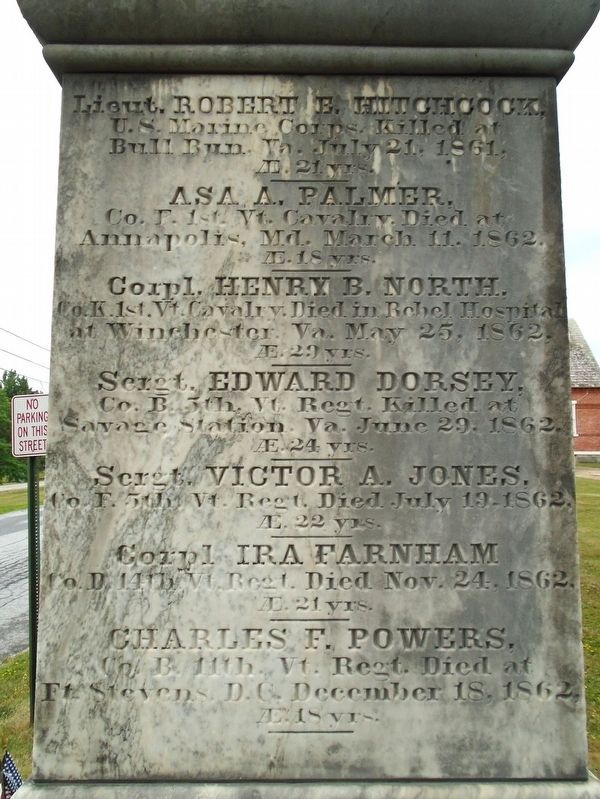
Erected by the Town of Shoreham
in honor of her patriotic dead,
who fell during the Rebellion of 1861.
Her offering on a country's altar:
a sacrifice to liberty and union.
Lieut. ROBERT E. HITCHCOCK,
U.S. Marine Corps. Killed at . . . — — Map (db m281334) WM
The most active man in procuring Charter for Shoreham in 1761, and in effecting its early settlement; engaged upon Military Road in 1759; and an officer in French and Revolutionary Wars; who came with others from Worcester, Mass. and cleared the . . . — — Map (db m281335) HM WM
From Hands Cove northwest from this spot
Ethan Allen with eighty-three Green Mountain Boys
embarked for the capture of Fort Ticonderoga May 10 1775
To commemorate
one of the most heroic adventures of the Revolution
this tablet has been . . . — — Map (db m118290) HM
John Larrabee established the first regular ferry here under a grant from the Vermont Legislature when the only business at the site was his tavern. In 1823, the year that the Champlain Canal opened, Larrabee and Samuel Holley built a store and a . . . — — Map (db m15580) HM
Levi Parsons Morton, son of a minister, was born on this site, May 16, 1824, and for 8 years lived in Shoreham. He became a New York City banker, Member of Congress, Minister to France, Vice-President under President Harrison, and Governor of New . . . — — Map (db m95458) HM
Born at Shoreham, Vermont
May 16, 1824
Died at Rhinecliff[,] New York
May 16, 1920
Member of Congress
Minister to France
Governor of New York
Vice President of the
United States of America — — Map (db m281338) HM
This Howe truss Railroad Bridge is one of only two covered railroad bridges left in Vermont. It was built in 1897 on the 15.6 mile Addison Branch connecting the Rutland Railroad at Leicester Junction with the Delaware and Hudson at Ticonderoga, New . . . — — Map (db m85416) HM
One of the oldest ferry crossing in North America
Established in 1759 by Lord Jeffery Amherst to
connect the forts on Lake Champlain with those
on the Connecticut River — — Map (db m281403) HM
In Memory Of Those Who
Served In World War II
Robert Post ★ • Harold DeLong ★
Elizabeth Baldwin • Beatrice Cook • Evangeline Sabourin
Raymond Aunchman • Howard Austin • William Birchard • Charles Bridges
Robert Brisson . . . — — Map (db m281289) WM
In honor of
our Boys of the Town of Shoreham
who served the American Colors in
the Great World War
★Arthur F. Aunchman • ★Archie Austin
Harry G. Baldwin • Ashley M. Belden • Albert Bourdeau • William A. Brileya
Wilfred . . . — — Map (db m281307) WM
Intersection of Rivers and Roads
Imagine traveling hundreds of miles in an ox-drawn wagon along muddy, rock-strewn, deeply rutted roads through the wilderness. In search of new homesteads, early settlers followed the same routes you took to . . . — — Map (db m89157) HM
Victorious commander
of the American Fleet
in the naval battle of
Plattsburg
September 11, 1814
A Gallant Officer
An Exemplary Citizen
A National Hero
Memorial
erected to commemorate
the building by
Commodore Macdonough
of . . . — — Map (db m109195) HM
The Wilderness
Shhh. Imagine Otter Creek 300 years ago when it was pristine wilderness. The river teems with fish, herons, ducks and other waterfowl. Deer and moose tracks dot the river's edge. Downed trees, trampled shrubs, and mounds of . . . — — Map (db m89155) HM
In Remembrance of
our departed Sisters
and Brothers
Dedicated to our Brothers
[Armed Services and POW/MIA
and First Responder Emblems] — — Map (db m281287) WM
Below the Otter Creek Falls was the site of Thomas Macdonough's shipyard, where the U.S.S. Saratoga was built in 40 days and other ships launched that defeated the British at the Battle of Plattsburgh, 1814. — — Map (db m75977) HM WM
Stephen Bates (1842-1907) was born enslaved on the Shirley Plantation in Virginia. He escaped in 1862 and after the Civil War came north to Vergennes with U.S. Congressman Frederick E. Woodbridge. Bates was first elected Sheriff in 1879 and served . . . — — Map (db m195671) HM
In Need of Water
Fire was the scourge of downtowns all across America in the nineteenth century. Buildings were destroyed by fire time and time again. Water often had to be transported from nearby rivers. Firefighting efforts were frequently . . . — — Map (db m89159) HM
Honor Roll
[Died in service]
Philip E. Goodere • Edward L. Mercure
Frederick C. Morris • Hobart P. Preston
[Veterans Honor Roll not transcribed] — — Map (db m109197) HM
Charity Bryant (1777-1851) and Sylvia Drake (1784-
1868) met in 1807 in Weybridge, where they lived
and were accepted as a couple. They had a
cottage on Hagar farm. joined the local
church and charities, and ran a tailoring business.
Charity's . . . — — Map (db m305701) HM
(south side) Weybridge was chartered by N.H. in 1761 and settled in 1775 by Thomas Sandford, David Stow, Justus Sturdevant & Claudius Britell.
Nov. 8, 1778, a party of British Torries & Indians destroyed their houses and effects & . . . — — Map (db m262501) HM WM
Born at Amherst, Mass., Silas Wright came to Weybridge as an infant and grew up here. Graduated from Middlebury College in 1815, he studied Law at Sandy Hill, N.Y.; began Law practice at Canton, N.Y. in 1819, and entered politics there. A Brigadier . . . — — Map (db m77967) HM
The U.S. Government established a Morgan horse breeding program in 1905 at the University of Vermont to study and refine the Morgan horse as a superior cavalry mount. That program moved here in 1907 when Joseph Battell donated this farm to the U.S. . . . — — Map (db m77965) HM
He lies buried in this cemetery. He walked 64 miles to recruit men to aid Ethan Allen in the capture of Fort Ticonderoga, May 10, 1775. — — Map (db m136470) HM
This renowned American painter and illustrator lived in Arlington from 1939 to 1953. Moving into this house in 1943, Rockwell employed neighbors as models to create memorable images for calendars, advertisements, and magazines. Iconic pictures like . . . — — Map (db m97290) HM
This ancient tree was already a monarch of the forest in 1778. Visible then from the Arlington home of Thomas Chittenden, first Governor of Vermont, it is believed to have inspired Ira Allen in designing Vermont's Great Seal. Note a similarity . . . — — Map (db m90228) HM
Oldest frame building one block east, built by Jehiel Hawley, 1764, was home of Thomas Chittenden, Vermont’s first Governor. Legend says the western vista, with its great pine, became the State Seal in 1779. Ethan and Ira Allen lived nearby. — — Map (db m78249) HM
Known for her depiction of rural life in Vermont, Fisher was a popular novelist and proponent of education. She introduced the Montessori teaching method to American readers and helped found the Adult Education Association in the U.S. Born in . . . — — Map (db m78248) HM
Prior to Vermont becoming a state, settlers holding land titles from New Hampshire conflicted with New York authorities who claimed the same lands. Remember Baker was one such settler, building a grist mill and homestead in East Arlington in 1764. . . . — — Map (db m285974) HM
On the morning of September 11, 2001, two hijacked jetliners were flown into the twin towers of New York's Trace Center, a third jetliner dove into the Pentagon, and after passengers attempted to wrest control from the terrorists on board, a . . . — — Map (db m303947) HM
Artists & Craftspeople
Numerous jewelry and fiber designs, metal work, pottery, sculpture, photographing, painters, and furniture have setup shop in Bennington over the years. It's a beautiful environment to expand creativity, business, . . . — — Map (db m303959) HM
Bennington County is comprised of 17 towns and is the only Vermont county with two shire towns (county seats): Manchester in the Northshire (nine towns) and Bennington in the Southshire (eight towns). The two shire towns are linked by the scenic . . . — — Map (db m303935) HM
Air Force
Cumm, Timothy C. •
Gulley, Sr. James A. •
Vesper Richard Richard J.
Army
Becker Franklin •
Becker Jr. Ralph W. •
Mahoney Robert J. •
Merrow Jr. James A. •
Moore Patrick M. •
Moore Jr. Thomas F. • . . . — — Map (db m305812) WM
At My Quarters,
Derryfield, 31st July, 1809.
My Friends and Fellow Soldiers:—I received yours of the 22nd, instant, containing your fervent expressions of friendship, and your very polite invitation to meet with you, to celebrate the . . . — — Map (db m303942) HM WM
Why Is It Called The Battle of Bennington?
It would be better to say it was the Battle for Bennington, because the target of the British raid was a Continental supply depot where the Bennington Monument now stands. The raiders never . . . — — Map (db m303954) HM
Italianate home of the father of Trenor W. Park, who built the Park-McCullogh House in North Bennington, with some of the fortune he made in California.
State Register of Historic Places — — Map (db m303897) HM
Built to sell & service the expanding number of private motor cars
Subsequent manufacturing uses
National Register Historic District — — Map (db m303944) HM
Built for Luman Norton and his son-in-law Christopher Fenton. The family's various pottery firms manufactured ceramics from 1785 to 1893.
State Register of Historic Places — — Map (db m303896) HM
Post office 1913-1967. US federal building 1967-1996. Acquired by the town of Bennington in 1997 from the federal government through the General Services Administration under the Historic Surplus Property Program, a program of the National Park . . . — — Map (db m198075) HM
Recreation for All Seasons
Bennington is located at the southern end of the Valley of Vermont and is drained by the Walloomsac River, a tributary of the Hoosic that flows into the Hudson. The Green Mountains rise to the east and the . . . — — Map (db m303957) HM
Shaffe’s
c.1850/1963
Store throughout
its history. 1963 front retained
in restoration after
1992 fire.
State Register of Historic Places — — Map (db m141048) HM
Built for Bottom and Torrance adjoining an 1836/1892 mill. Later, Thomson Mill office until 1985. Moved here in 1987 from West Main Street.
National Register Historic Districts — — Map (db m303963) HM
Constructed by Luther R. Graves to serve Bennington's growing commercial downtown in the post-Civil War years. Restored in 1996.
National Register Historic District — — Map (db m303962) HM
This ornate Victorian fountain graced the entrance to the Bennington Graded School from 1875 until the building was razed in 1954. It symbolized the essence of a school system considered the best in the State and a building of "elegance of . . . — — Map (db m303945) HM
Henry G. Root homestead transferred to the Town by his descendants for municipal purposes in 1920
National Register Historic District — — Map (db m197554) HM
“I could not look upon the peaks of Ascutney, Eillington, Mansfield, and Equinox without being moved in a way that no other scene could move me. It was here that I first saw the light of day; here i received my bride; here my dead lie . . . — — Map (db m77057) HM
Site of
Dimick Tavern
where
John Stark
and his New Hampshire Volnteers
camped before the engagement at
Walloomsac Heights
where they led in the winning of a decisive victory . . . — — Map (db m105506) HM
Senator James Merrill Jeffords
Described by his colleagues as fiercely independent, courageous, low-key and down-to-earth, Senator Jeffords was an exemplary Vermont leader. He served in state offices for six years before . . . — — Map (db m280349) HM
Vermont Does Its Full Duty
On April 12, 1861, President Lincoln sent a telegram asking
Governor Erastus Fairbanks, "What can we expect of Vermont?"
"Vermont will do its full duty" was his reply.
Vermont continued to do . . . — — Map (db m280352) WM
Named in honor and in memory of all WWII Veterans
and their families. You saved the world for all of us.
Vermont thanks you for your service.
You will never be forgotten!
Erected August 15, 2015 — — Map (db m280381) WM
Dedicated to the honor and sacrifice of our men and women who served our country in war and peace
Gifted by Abe Noveck
Charter Member
1892 - 1991 — — Map (db m303971) HM WM
Near this site
stood the homestead of
Lieut. James Breakenridge
after years of peaceable possession his farm was claimed by New York land speculators - A sheriff and over three hundred men came from Albany to evict him from his home - . . . — — Map (db m77019) HM
This quiet spot was once a major river crossing. Traffic between southwestern Vermont and New York State crossed here, until the railroad was built in 1852, troops marched from Manchester, Vermont to the Battle of Bennington in 1777, and teams and . . . — — Map (db m77062) HM
A Bridge from Past to Present
You are standing at a hub of Vermont history. The Green Mountain Boys were born here. General John Stark and Colonel Seth Warner marched on to victory at the nearby 1777 Battle of Bennington through here. This . . . — — Map (db m193190) HM
A Brief History
The Village of North Bennington established McWaters Park in 2007. The Park is named in honor of Rob and Jean McWaters in recognition of local community involvement. Residents are
creating a perma forest consisting of berry . . . — — Map (db m193197) HM
Paper Mill History The former Vermont Tissue plant is located in Bennington in "Paper Mill Village” on the north side of the island on the Walloomsac River. The plant is a listed Brownfields site. The site is privately owned by AOE, Inc. who . . . — — Map (db m193206) HM
Built as a summer cottage in 1865 for lawyer-entrepreneur-philanthropist Trenor Park and his wife Laura, the mansion was financed with a fortune amassed in California in the aftermath of the California Gold Rush. It was designed by the New York . . . — — Map (db m94423) HM
The North Bennington Railroad Station was constructed in 1880, replacing an earlier wood frame station located on the same site.
For over half a century, the depot served as the gateway to the village.
Beginning in the 1930’s, with the gradual . . . — — Map (db m116755) HM
Forty feet west of this spot
stood the home of
Seth Warner
Colonel of the Green Mountain Boys,
during his residence in Bennington.
Hero of Hubbardton and Bennington
Battles, 1777.
The house was destroyed by fire
in 1858.
Erected . . . — — Map (db m193183) HM
A Bridge From An Industrial Past to a Green Future
In New England, the industrial revolution was driven by water power.
With its many rivers, this made Bennington an early leader in manufacturing of many types. Many of these dams now lie . . . — — Map (db m193203) HM
Editor and publisher the Vermont Gazette
Bennington
Uncompromising in defense of freedom of the press
Imprisoned in 1800 for opposition to Alien and Sedition Laws as threats to the newborn democracy
Erected in 1912
On site of first . . . — — Map (db m77021) HM
The expedition led by Lieut. Col. Baum sent to seize military stores here, was defeated by volunteer American militia forces from New Hampshire, Massachusetts and Vermont, commanded by General John Stark, aided By Colonels Warner and Herrick, of . . . — — Map (db m13649) HM
was built there was no circular road on this hill top. The original road from Williamstown, Mass. came through Pownal, Vt. to Bennington, and continued straight through the village, over this hill north towards Shaftsbury.
All of the buildings . . . — — Map (db m77051) HM
On August 16, 1777, British forces sent by Gen'l Burgoyne to seize supplies at Bennington were turned back by New Englanders under Gen'l John Stark and Vermont's Col. Seth Warner. This 306 foot commemorative shaft planned 100 years later, was . . . — — Map (db m13600) HM
To the memory of the men from Bennington whose patriotism helped to maintain and perpetuate the Union 1861 – 1865 A tribute by Bennington Post no. 13, American Legion Dedicated at the Department Convention of the Legion, the first held in . . . — — Map (db m105774) WM
Near this spot in 1761
Captain Samuel Robinson
the pioneer settler of Bennington, the first magistrate in what is now Vermont, and during his lifetime, the acknowledged leader of the settlers of the town built his first log cabin. . . . — — Map (db m77052) HM
The Warner monument has text on the four sides of the base Born in
Roxbury (then Woodbury) C.T. May 17, 1743
Resided in
Bennington VT. 1765-1784
Died Dec. 26, 1784 at Roxbury CT
Where he was buried with Honors of War
Age 41 . . . — — Map (db m77023) HM
On this site
stood the
Continental Storehouse
Object of
the British attack
that was repulsed
by the Colonial Forces
at the
Battle of Bennington
August 16, 1777 — — Map (db m14828) HM
Brigadier General John Stark 1728 – 1822 Victor of the Battle at Bennington 1777 “There they are boys! We beat them today Or Molly Stark sleeps A widow tonight!” Design by John Rogers – 1889 Sculpture by Robert Shure Gift of John Brooks Threlfall . . . — — Map (db m105507) HM
Erected in honor of Brigadier General John Stark and the 1400 New Hampshire men who came to the defense of Vermont in August 1777. Assembling at Fort Number Four in Charleston, New Hampshire, Stark and his troops crossed the Green Mountains to . . . — — Map (db m77022) HM
This marker commemorates the men and women who achieved American independence. These Patriots, believing in the noble cause of liberty, fought valiantly to found a new nation.
1775 - 1783
Presented by Vermont State Society, . . . — — Map (db m303967) WM
Seth Warner came to Bennington in 1763, followed later by his cousins Ethan Allen and Remember Baker in an area known as the New Hampshire grants. In 1770, as the leaders of the Green Mountain Boys, the men joined forces against the threat of New . . . — — Map (db m303968) HM
The Catamount Tavern, which was built in 1767, was originally named the Green Mountain Tavern. The Council of Safety and the “Green Mountain Boys” met here from 1767 to 1775. On May 9, 1775, Ethan Allen and 270 men, 40 whom were “Green Mountain . . . — — Map (db m77053) HM
When wealthy North Bennington resident Trenor Park purchased the Bennington-Rutland Railroad, he found that the railroad "barons" of the Troy and Boston Railroad refused him access to the New York lines. Rather than fight this monopoly, Park built a . . . — — Map (db m36902) HM
State Highway 9 traverses scenic Hogback Mt. to the Connecticut River Valley. Old Bennington, site of the Battle Monument and Historical Museum, was the meeting place of the Green Mountain Boys. It was the first town chartered by Governor Benning . . . — — Map (db m94427) HM
Whereas, the Old First Church of Bennington was
organized December 3, 1762, and is the Oldest Church
within the present limits of Vermont; and
Whereas, our forefathers met in Prayer in the First
Meeting House for assistance against the . . . — — Map (db m28223) HM
View of the hill top where the Battle Monument stands today, painted in 1798 by Ralph Earl. It shows the State Arms Inn (brick) on the left and in the middle the first Court House, which burned on May 17, 1809. The second Court House built on the . . . — — Map (db m161886) HM
Fifty feet west of this spot William Lloyd Garrison edited the Journal of the Times October 3, 1828 – March 27, 1829 Hither came Benjamin Lundy December 6, 1828 to enlist him in the cause of the slave. Garrison departed hence to lift up in . . . — — Map (db m90235) HM
Vermont veterans dedicate this monument to our Gold Star Mothers whose sons and daughters made the ultimate sacrifice while serving in the Armed Forces of the United States. — — Map (db m304158) WM
Bates, Norman F. •
Benedict, George G. •
Blair, Robert M. •
Breault, Henry •
Bresnahan, Patrick Francis •
Butterfield, Frank G. •
Churchill, Samuel J. •
Coffey, Robert J. •
Davidson, Andrew •
Davis, George E. •
Downs, Henry W. . . . — — Map (db m304162) WM
The price of a silver rose is not free
"They gave their tomorrows for your todays"
In memory of the men and women who served, in the Vietnam War and later died as a result of Agent Orange dioxins
We honor an remember their . . . — — Map (db m304164) WM
In 1884, the State General Assembly authorized an initial $10,000 appropriation to establish a soldiers’ home to care for disabled veterans of the Civil War. The former country estate of Seth B. Hunt, erected in 1860, was chosen. The Soldiers’ . . . — — Map (db m108851) HM
The board of trustees of the Vermont Veterans' Home dedicates this monument to those men and women who served in the Armed Forces of the United States — — Map (db m304163) HM
Vermont Society of Colonial Dames
Historic Marker
Site of
Cephas Kent's dwelling
adjacent the
Cephas Kent Inn
where
the First Convention of the New Hampshire
Grants was held in 1776
The Dorset Conventions
July 24, 1775
Seth . . . — — Map (db m159535) HM
Jonathon Fenton established a pottery and kiln near this site in 1801. He first made redware from clay found along the banks of the Mettowee River. He then became the first potter in Vermont to make salt-glazed stoneware. In 1810 he moved his . . . — — Map (db m78224) HM
Here, near Mt. Aeolus, Isaac Underhill opened the first marble quarry in 1785. Dorset quarries were most active in early 1800's when small slabs were used for hearths, doorsills and headstones. With better transportation and saws, larger blocks . . . — — Map (db m78226) HM
1115 entries matched your criteria. Entries 101 through 200 are listed above. ⊲ Previous 100 — Next 100 ⊳