On Main Street (U.S. 287) near North 2nd Street, on the right when traveling west.
The Lander Hotel was one of the first businesses on Lander’s dusty Main Street. It began as an eating place and stopover for bull-team freighters on their way to Fort Washakie. It was a one-story, four-room log building built by Ben Decora. Later . . . — — Map (db m95961) HM
On East Main Street (U.S. 287) near North 1st Street, on the right when traveling west.
Scouts and Trappers visited this area by 1811 and rendezvous were held in 1829, in 1830, and in 1836.
Camp Magraw, 1857, site 2.1 miles north.
Fort Thompson, 1857-1858, was located 4.4 miles north of here.
Camp Augur, 1869-1870, . . . — — Map (db m95785) HM
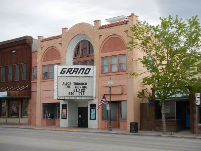
On Main Street (U.S. 287) near South First Street, on the left when traveling west.
By 1887-88 the farmers were pushing for a local flour mill and went as far as putting up some of their own money to entice someone to take on the project. At that time, wheat was grown in abundance but little was sold except as chicken feed. J. D. . . . — — Map (db m95967) HM
On Main Street (U.S. 287) near North 3rd Street, on the right when traveling west.
Major Noyes Baldwin and his wife, Josephine Wright Baldwin, were some of the earliest settlers in the Lander Valley. Before establishing the dry good store in Lander, he had a trading post near Hudson, Wyoming, a log trading post on Baldwin Creek, . . . — — Map (db m95946) HM
On Main Street (U.S. 287) near South 2nd Street, on the left when traveling west.
J.K. Moore, post trader at Fort Washakie, built the large store shown in mid-photo in the early 1880s. It was later to be one of the most elaborate saloons in the entire west, fitted out with glassware and furniture cut in the shape of diamonds. . . . — — Map (db m95868) HM
On Main Street (U.S. 287) near North 3rd Street, on the right when traveling west.
The Noble Hotel has been a landmark in downtown Lander since it was built in 1918. The grand hotel was built to serve visitors from the East on their way to Yellowstone. Harold Del Monte bought the hotel in 1929 and set out to recreate the Noble as . . . — — Map (db m95947) HM
On Main Street (U.S. 287) near North 3rd Street, on the right when traveling west.
This building was the second home to the Noble and Lane Mercantile Business. The face of the mercantile building has changed. It was originally built by Worden P. Noble and Albert D. Lane in 1891. The stone building next to it is where their . . . — — Map (db m95944) HM
On Oregon Buttes Road at Emigrant Trail, on the left when traveling south on Oregon Buttes Road.
To the south stand the Oregon Buttes, a major trail landmark. The name is significant because the Buttes were roughly the beginning of the Oregon Territory and also helped keep emigrants encouraged, even though there were still hundreds of miles of . . . — — Map (db m80499) HM
On Main Street (U.S. 287) near South 2nd Street, on the left when traveling west.
In 1891, Eugene Amoretti, successful businessman and one of the “town fathers,” financed the construction of this building. It was the original home of the Palace Pharmacy. The building was large enough to house many different . . . — — Map (db m95970) HM
Near Sinks Canyon Road (State Highway 131), on the right when traveling west.
In 1919 the Sinks Canyon Hydro Electric Company built a power plant in the canyon to provide electricity for Lander. A dam was built upstream of the Sinks. The dam diverted part of the Popo Agie River into a pipeline which carried the water to the . . . — — Map (db m95820) HM
On Dickinson Avenue (State Highway 28) at Red Canyon Road, on the right when traveling west on Dickinson Avenue.
Red Canyon is cooperatively managed by the Wyoming Game and Fish Department, the State of Wyoming, the Bureau of Land Management and private landowners.
The spectacular orange and red sandstone formations you see here have been exposed through . . . — — Map (db m80132) HM
On Dickinson Avenue (State Highway 28) near Red Canyon Road, on the right when traveling west.
The Red Canyon Wildlife Habitat Management Area (WHMA) before you is a crucial part of the entire winter range complex along the Southern Wind River Mountains in the Lander Area. The 1785 acres of the Red Canyon WHMA were purchased in 1958 primarily . . . — — Map (db m96368) HM
On Dickinson Avenue near Skyline Road, on the right when traveling west.
In 1842, gold was first found in the Wind River Mountains of Wyoming by a fur trapper, Georgia Tom Mckeever of the American Fur Company. Mckeever passed before he could get his gold to an assayer, leaving location unknown. Given the hostile . . . — — Map (db m152989) HM
On Oregon Trail, on the right when traveling west.
At 7000 feet above sea level, Rocky Ridge is the highest point on the Mormon and Oregon Trails. This elevation, lack of water, and rugged landscape presented a challenge to early pioneers. The trail over Rocky Ridge is approximately two miles long . . . — — Map (db m96621) HM
On Sinks Canyon Road (State Highway 131), on the right when traveling west.
From the time the glaciers of the last Ice Age retreated about 16,000 years ago, people have journeyed into Sinks Canyon. The canyon is a natural pathway into and over the southern Wind River Mountains. For thousands of years people, and wildlife, . . . — — Map (db m95818) HM
On Sinks Canyon Road (State Highway 131), on the left when traveling west.
The heavily timbered slope before you provides excellent habitat for many species of wildlife. Douglas Fir trees with Oregon Grape, Mountain Lover, Snowberry, Wild Rose and many other shrubs in the under story, cover the slope. Vegetation is thicker . . . — — Map (db m95825) HM
On State Highway 789 near Chittim Road, on the left when traveling north.
In 1856 the United States Congress appropriated money to build the central division of the Fort Kearney-South Pass-Honey Lake Wagon Road from Nebraska to California. W.M.F. Magraw was appointed superintendent by the Secretary of the Interior. He was . . . — — Map (db m96164) HM
Near State Highway 28, 0.8 miles north of Lander Cutoff Road.
The South Pass, in which you are now located, is perhaps the most significant transportation-gateway through the Rocky Mountains. Indians, mountain men, Oregon Trail emigrants, Pony Express riders, and miners all recognized the value of this . . . — — Map (db m67016) HM
Near State Highway 28, 0.7 miles south of Lander-Pinedale Stage Road.
From where you're standing South Pass doesn't look all that remarkable. But compared to the rugged Wind River Mountains, it can easily be recognized as a type of gateway.
Nevertheless, crossing the Continental Divide into "Oregon Country" was a . . . — — Map (db m67020) HM
Near State Highway 28, 0.7 miles south of Lander-Pinedale Stage Road.
Even after the discovery of South Pass in 1824, it was years before the route was used extensively. Fur trapper/trader William Sublette brought a small caravan of wagons to South Pass in 1828. While his party did not take wagons over the pass, they . . . — — Map (db m67021) HM
South Pass was discovered in 1812 by a small band of Astorians led by Robert Stuart as they traveled east with dispatches for John Jacob Astor. It was “rediscovered” in 1824 by a party led by Jedediah Smith as they searched for a winter . . . — — Map (db m80501) HM
On State Highway 28, 1.1 miles north of Louis Lake Road, on the right when traveling south.
The hills of the Sweetwater Mining District hold various minerals, and beginning in the 1960s, iron ore mining provided an economic boom for the area. In 1960 the U.S. Steel Corporation broke ground on the nation's highest open pit iron ore mine at . . . — — Map (db m67014) HM
Near State Highway 28, 0.7 miles south of Lander-Pinedale Stage Road.
The trail over South Pass is a transportation corridor which served many purposes. In addition to being the route to Oregon and California, it was used by Mormon pioneers and by the Pony Express.
A great exodus to the Salt Lake Valley in 1847 . . . — — Map (db m67019) HM
Near State Highway 28, 0.7 miles south of Lander-Pinedale Stage Road.
The demand for beaver pelts in the early 1800s led to the exploration and eventual settlement of the American West. South Pass was part of a major thoroughfare through the Rockies and its discovery is significant to the era known as the fur trade. . . . — — Map (db m67022) HM
The Oregon Trail
In memory of those who passed this way to win and hold the West
Plaque placed by the Historical Landmark Commission of Wyoming
1950 — — Map (db m80504) HM
On Sinks Canyon Road (State Highway 131), on the right when traveling west.
The Rise of the Sinks is a large spring where the water of the middle fork of the Popo Agie River reappears after flowing into a limestone cavern called the Sinks, located a quarter of a mile upstream.
The water flows underground following an . . . — — Map (db m95819) HM
Near State Highway 28, 0.7 miles south of Lander-Pinedale Stage Road.
With South Pass behind them, Oregon and California-bound travelers faced the second half of their journey. The roughest travel was yet to come. From Missouri to South Pass, emigrants were able to follow rivers. But from South Pass to Oregon and . . . — — Map (db m67018) HM
On Wyoming Route 28, on the right when traveling north.
The Twin Mounds are a minor landmark along the Trail. These low hills on either side of the Trail helped keep emigrants headed in the right direction on the final climb to South Pass.
After the wagons passed between the Mounds, they fanned out . . . — — Map (db m237435) HM
On Oregon Trail, on the right when traveling west.
The James G. Willie Handcart Company was rescued on October 21, 1856 by a rescue party sent by Brigham Young. 21 members of the Willie Company perished in this valley due to a severe winter storm and lack of clothing and food. Captain Willie left in . . . — — Map (db m96622) HM
On North Federal Boulvard (State Highway 789) at East Fremont Avenue on North Federal Boulvard.
In memory
of the Trappers, Traders
and Explorers, who
established the Rendezvous
at the Junction of the
Little and Big Wind Rivers — — Map (db m80127) HM
On U.S. 20, 0.4 miles north of Brannon Road, on the right when traveling south.
Rocky Mountain bighorn sheep once roamed much of the western United States. Now, these magnificent animals are found in only a fraction of their historic range. Human expansion, disease, market hunting and fire suppression all contributed to the . . . — — Map (db m88979) HM
In 1952, dignitaries dedicated a new dam built by the Bureau of Reclamation, one and half miles upstream from Asmus Boysen’s historic dam. Construction began with blasting of a tunnel to divert the river and included relocation of both the highway . . . — — Map (db m88138) HM
In the early 1900s, Asmus Boysen, a Danish immigrant and successful businessman, dreamt to building a dam that would provide water and power to Central Wyoming. The dam was to be an engineering achievement, spanning 180 feet high and 124 feet long, . . . — — Map (db m167191) HM
The Wind River Canyon provides a unique slice through geologic time. While driving through the canyon, you can see rocks that were deposited when life was beginning and when Wyoming was covered by a sea with a tropical climate similar to the . . . — — Map (db m88141) HM
On U.S. 20 at Lower Wind River Road, on the right when traveling south on U.S. 20.
Mule teams hauled the materials for the original Boysen Dam, built here in the early 1900s by Asmus Boysen to provide power for his gold and copper mining interests in this area. A few years later when the Burlington Railroad built through . . . — — Map (db m88147) HM
On U.S. 20, 0.4 miles north of Brannon Road, on the left when traveling north.
Boysen Dam, completed in 1951, marks the southern margin of the east-west trending Owl Creek Mountains and the Wind River Canyon. Drained by the north flowing Wind River, the canyon is 14 miles long, 1.3-2 miles wide and 2,400 feet deep where it . . . — — Map (db m70611) HM
An arrastra is a type of primitive mill used to crush ore and extract gold and silver. Water diverted from Willow Creek turned the large water wheel to provide power. A drive shaft connected to the wheel rotated a series of cogwheels that in turn . . . — — Map (db m154156) HM
On South Pass Main Street near South Pass City Road / B Street, on the right when traveling east.
Two related, side-by-side markers pay tribute to Esther Hobart Morris.
Home & office site of
Esther Hobart Morris
First woman Justice
of the Peace
in the World
Feb. 14, 1870 . . . — — Map (db m80149) HM
On South Pass Main Street near South Pass City Road / B Street, on the right when traveling west.
1869 - 1925
Site of
First Masonic Lodge in Wyoming
No. 28
under jurisdiction of Nebraska
Now
Wyoming Lodge No. Two
Lander, Wyoming — — Map (db m80150) HM
As early as 300 BC, the Greeks use the primary components of a stamp mill - drive wheel, cams, and stamps - for pounding and hauling grain. The concept was adapted to crushing ore and became widely used in America as a gold recovery process.
. . . — — Map (db m154146) HM
On Dickinson Avenue (State Highway 28) near Lander Cut-Off Road, on the left when traveling south.
In 1858, this ancient path, which had been used by Indians, explorers and mountain men as a short cut to the Snake River country was developed by Frederick Lander in to an alternate route on the Oregon Trail. What is commonly called the Lander Trail . . . — — Map (db m80161) HM
On Dickinson Avenue (State Highway 28), on the right when traveling south.
With spring, the meadow grasses and broad-leafed plants, called forbs, emerge green and succulent. Antelope, mule deer, and elk wintering south and west of here return each spring to the green grass and forb meadows found in the sagebrush desert and . . . — — Map (db m96700) HM
On Emigrant Trail near Lander Pinedale Stage Road, on the left when traveling north.
For many emigrants, the first tangible evidence that the had crossed South Pass was Pacific Springs, "the fountain source of the Pacific streams," according to pioneer Joseph Goldsborough Bruff. The broad expanse of the pass from Pacific Springs . . . — — Map (db m96660) HM
On Dickinson Avenue (State Highway 28) near South Pass City Road / B Street, on the right when traveling west.
A region rich in history. A city rich in gold. From 1812 to 1868 this open country at the end of the Wind River Mountains provided a passage - the only passage - through the Rocky Mountain barrier of the Continental Divide for some 500,000 westering . . . — — Map (db m80160) HM
On South Pass Main Street near Price Street, on the left when traveling east.
Founded 1868
A Great Gold Camp
Part of Wyoming’s historical heritage. Acquired for preservation May 18, 1966, with funds raised by Wyoming;s 75th Anniversary Commission Inc., its advisers, county committees and people of . . . — — Map (db m80162) HM
On South Pass City Road near South Pass Road, on the left when traveling south.
Emigrant travelers on their way west likely discovered small amounts of gold in the 1840’s, but it took until 1868 for the first mining claims to be staked. Word of the new gold rush spread and the summer of 1868 brought an influx of people from . . . — — Map (db m80148) HM
On South Pass City Road near South Pass Road, on the left when traveling south.
Thousands rushed to the South Pass area following the find of substantial gold deposits at the Carissa Mine in 1867. As the boom gained steam, the Carissa sat at the center of mining development, serving as the primary economic force for South Pass . . . — — Map (db m80146) HM
Near Lewiston Road near Oregon Trail, on the left when traveling east.
Captain James G. Willie’s Handcart Company of Mormon emigrants on the way to Utah, greatly exhausted by the deep snow of an early winter and suffering form lack of food and clothing, had assembled here for reorganization by relief parties from Utah, . . . — — Map (db m80154) HM
On Wyoming 789 (U.S. 287) near Wyoming Highway 135, on the left when traveling west.
Oregon-Mormon Trail
and Sixth Crossing
of Sweetwater River
Willie Handcart Company rescue site, 21 October 1856 and burial site of John Winford and eight others from that company
John Linford
Born 28 August 1808 England
Died . . . — — Map (db m95742) HM
On Wyoming 789 (U.S. 287) at Wyoming Highway 135 on Wyoming 789.
The modern burg of Sweetwater Station is at the intersection of U.S. Highway 287 and State Route 135 in central Wyoming along the Sweetwater River. It is a place of scenic beauty and historic significance. Prehistoric groups camped along the . . . — — Map (db m95745) HM
On Wyoming 789 (U.S. 287) at Wyoming Highway 135, on the right when traveling west on Wyoming 789.
In summer, the trilling “Kroo-oo-oo” of the sandhill crane is heard along the Sweetwater River. The endangered whooping crane has been seen in the marshy meadows immediately south of this spot. The Sweetwater’s wide floodplain, enhanced . . . — — Map (db m95747) HM
Near Wyoming 789 (U.S. 287) at Sand Draw Road (Wyoming Highway 135), on the right when traveling west.
The Sweetwater Valley is the mid-section of the 2000 mile-long Oregon Trail. West of Casper, Wyoming, branches of that trail, meld into a single transportation corridor and here, paralleling the serpentine Sweetwater River, the trail approaches the . . . — — Map (db m95776) HM
Near Wyoming 789 (U.S. 287) near Wyoming Highway 135, on the left when traveling west.
Late in the year of 1856, the Willie and Martin Handcart Companies and the Hunt and Hodgetts Wagon Companies left Iowa City for their journey westward. Near this spot, these companies crossed the Sweetwater River for the sixth time, thus the name . . . — — Map (db m95743) HM
Near State Highway 160, on the left when traveling west.
It is one of the most commonly asked questions here – and with good reason. Those who grew up watching western movies expect to see a fort with a large wooden stockade. Like many other aspects of Hollywood westerns, the walled military fort . . . — — Map (db m87076) HM
Near State Highway 160, on the left when traveling west.
This 1889 winter scene shows buildings along the west side of the Parade Ground which housed Fort Laramie’s officer complement – hence, “Officers Row”. RIGHT TO LEFT, the “Burt” House, the “Surgeon’s” . . . — — Map (db m87031) HM
Near State Highway 160, on the left when traveling west.
Some days since I received a messenger from [Sinte Gleska], head chief of the Brule Sioux, saying that his daughter had died on the way here and had begged her Father to have her grave made with the whites . . . Wishing to do him honor . . . . — — Map (db m87041) HM
Near State Highway 160, on the left when traveling west.
The large structure built on this site in 1885 – pictured shortly after completion – was put to many uses. The section on the far right was used as a schoolroom for officers’ children. The central portion housed the Headquarters . . . — — Map (db m87005) HM
Near State Highway 160, on the left when traveling west.
“French, Spanish and Indian and mixed are very common here and all languages are being jabbered in promiscuous interchange.”Charles B. Darwin, Fort Laramie, June 28, 1849 Métis (ma-tes’) – of mixed race, particularly, . . . — — Map (db m87012) HM
Near State Highway 160, on the left when traveling west.
High ranking officers commonly kept chickens for their own use. The consumption of chickens and eggs provided a welcome change from meals of wild game and tough army beef. Individual soldiers and cooks utilizing company funds could purchase . . . — — Map (db m87024) HM
Near State Highway 160, on the left when traveling west.
Originally intended as housing for the commanding officer, this building was divided into a duplex when the C.O. chose to remain in another new dwelling. As such, the quarters was completed in 1870 at which time high-ranking officers and . . . — — Map (db m87009) HM
The building before you is the only surviving enlisted men's barracks at Fort Laramie. The building proper was completed in late 1874 and was designed to provide quarters and other needed support facilities for two companies of soldiers, The . . . — — Map (db m71018) HM WM
This building was completed in 1884. It was built as a commissary storage facility. As such it would have been primarily divided into two large storerooms: one for meat and one for flour, rice, and beans. Three or four smaller rooms would have been . . . — — Map (db m71017) WM
Near State Highway 160, on the left when traveling west.
Crossed the Laramie ford this morning and passed through the fort registering our names and found that . . . 16,913 men, Women 235, Children 242, Wagons 4,672, Horses 14,974, Mules, 4,641, Oxen 7,427, Cows 465, passed, besides nearly as many . . . — — Map (db m86975) HM
As the main outpost of the U.S. Government on the Northern Plains, Fort Laramie served as an official meeting ground between the United States of America and the sovereign tribes of the Northern Plains. The first great treaty negotiation, the . . . — — Map (db m86984) HM
Near State Highway 160, on the left when traveling west.
. . . the articles of trade consist, on the one side, almost entirely of buffalo robes; and, on the other, of blankets, calicoes, guns, powder, and lead, [and] . . . cheap ornaments such as glass beads, looking-glasses, rings, vermillion for . . . — — Map (db m86968) HM
A military post on the Oregon Trail June 16, 1849-March 2, 1890. This monument is erected by the State of Wyoming and a few interested residents — — Map (db m100065) HM
Fort Laramie was perhaps the single most important location in America’s expansion into the west. Founded in 1834 as a trading post, it became a military fort in 1849. Until it closed in 1890, Fort Laramie influenced major events in the history of . . . — — Map (db m71016) HM
On U.S. 26 near Otis Street, on the left when traveling north.
The epic story of America’s western expansion played out on a grand scale at Fort Laramie, where the North Platte and Laramie Rivers meet.
Fort Laramie was first established in 1834 as a private fur trading post. By the 1840’s, it served as an . . . — — Map (db m79778) HM
Near State Highway 160, on the left when traveling west.
In 1834, Robert Campbell and William Sublette established the first fort at the confluence of the North Platte and Laramie Rivers. Christened Fort William, the post was rectangular, measuring only 100 by 80 feet. Hewn cottonwood logs 15 feet high . . . — — Map (db m86958) HM
Near State Highway 160, on the left when traveling west.
In the 1880’s the Surgeon General determined that the privy vault - - “That most objectionable and dangerous nuisance” - - was a threat to the soldier’s health. His concern had been prompted by the accumulated reports from disgusted . . . — — Map (db m86996) HM
Near State Highway 160, on the left when traveling west.
The remains of the first guardhouse constructed in 1850, at Fort Laramie were discovered by workmen in 1960 during restoration of the “new” guardhouse. This site is a good example of the structural changes that occurred during the forts . . . — — Map (db m87001) HM
Near State Highway 160, on the left when traveling west.
We cannot afford to purchase wagons and teams as in times past. I am consequently thrown back upon my old plan – to make hand-carts, and let the emigration foot it . . . Brigham Young, 1855 Between 1856 and . . . — — Map (db m86981) HM
Near State Highway 160, on the left when traveling west.
In answer to the perpetual need for housing, construction of an enlisted men’s barracks commenced at the opposite end of these foundation ruins. The barracks were extended in this direction as more men were assigned. Kitchens, mess halls, . . . — — Map (db m87030) HM
Here on December 25, 1866
John (Portugee) Phillips
finished his 236 mile ride to obtain troops for the relief of Fort Phil Kearny after the Fetterman Massacre. — — Map (db m79773) HM
Near State Highway 160, on the left when traveling west.
Restored here to the 1850-1862 period, the magazine is among the oldest surviving structures at Fort Laramie. It was during this early period that George Balch, 1st Lieutenant, Ordnance Corps, sent the following report to the Assistant Adjutant . . . — — Map (db m168269) HM
Near Road 92 (County Route 50) near Gray Rocks Road, on the right when traveling west.
Mary Elizabeth Homsley was born near Lexington, Kentucky, July 20, 1824. She move with her parents, Jacob and Sarah Oden, to Truxton, Missouri, where she was married to Benjamin Franklin Homsley in 1841. In April 1852, accompanied by Mary's parents . . . — — Map (db m98361) HM
Near State Highway 160, on the left when traveling west.
As long as you behaved yourself and performed your duty as a soldier, you got along alright.Sergeant Perley S. Eaton, 3rd Cavalry Few soldiers completed their enlistments without experiencing the military justice system. Minor . . . — — Map (db m87003) HM
On East Merriam Street (U.S. 26) at Lawton Avernue on East Merriam Street.
Between the years 1847 and 1868, most of the approximate 80,000 Mormon Pioneers passed through Fort Laramie. This was the first stop for the vanguard company after leaving Winter Quarters, (near Omaha) Nebraska.
In June, 1847, after following a . . . — — Map (db m79776) HM
Near State Highway 160, on the left when traveling west.
Before you stand the remains of a six-unit apartment building constructed in 1884. Built for the fort’s senior noncommissioned officers and their families, this new structure provided the best housing available for married enlisted men on post. . . . — — Map (db m168233) HM
Near State Highway 160, on the left when traveling west.
This 1885 photograph shows the buildings constructed on this site in 1881. Previous adobe structures, built in 1855, were left standing as rear wings. On the far left was the Commanding Officer’s residence. Between 1881 and 1890 it was successively . . . — — Map (db m87026) HM
This graceful old structure, built in 1849, is the oldest standing building in Wyoming. It was nicknamed “Old Bedlam” because of boisterous sounds supposedly heard while it was occupied by bachelor officiers.
Shown in an 1889 . . . — — Map (db m79774) HM
Near State Highway 160, on the left when traveling west.
The parade ground was the center around which a variety of utilitarian buildings were constructed between 1849 and 1885. Though intended as a center of activities for the post with its parades and drills, Fort Laramie’s parade ground was not in . . . — — Map (db m87002) HM
Near State Highway 160, on the left when traveling west.
The job of building, maintaining, and supplying military posts belonged to the Quartermaster’s Department. The QMD was responsible for quarters, barracks, construction, infrastructure, transportation of personnel and supplies, and the procurement . . . — — Map (db m87105) HM
Near State Highway 160, on the left when traveling west.
I knew little about reading, spelling and arithmetic, while I was well versed in lightning, thunder, vapor and geography. Guy V. Henry Jr. on growing up at frontier military posts Wyoming’s first public school opened at Fort . . . — — Map (db m168463) HM
Near State Highway 160, on the left when traveling west.
Fort Laramie began as a dusty, drab frontier outpost as pictured above in the 1868 photograph. However, by the 1880’s, the Army had embarked upon a major cleanup and improvement campaign. The delightful results are evident in the 1887 view – . . . — — Map (db m87020) HM
Near State Highway 160, on the left when traveling west.
Through a succession of accidental fires, Fort Laramie’s sawmills gained a reputation of being oll-fated. The lime-grout building erected upon this site in 1887 was the last of several such structures that sheltered stream engines used for sawing . . . — — Map (db m87044) HM
Near State Highway 160, on the left when traveling west.
The Laramie River was unpredictable and unchecked by dams. High water during the spring of the year often damaged or washed away existing bridges; therefore, from 1853 to post abandonment in 1890 the river was spanned by several successive bridges . . . — — Map (db m86986) HM
On State Highway 160 near County Route 59, on the left when traveling west.
Once broad and turbulent, the North Platte River posed a formidable obstacle to 19th century travelers. High water made it nearly impossible to cross the river for several months each year. The crossing became less dangerous by 1850 when ferry . . . — — Map (db m79743) HM
On State Highway 160, on the left when traveling west.
“I am beginning to think the soldiers … know better how to handle pick and shovel than they do a gun …”Private George W. McAnulty, Fort Laramie, W.T., 1878 “ … nothing worries a soldier more than doing the dirty [work] . . . — — Map (db m87018) HM
Near State Highway 160, on the left when traveling west.
The “new” guardhouse, built in 1876 and shown in this 1887 view, was the last and most comfortable of three such structures at Fort Laramie. It was constructed upon the ruins of the original guardhouse, built in 1849-1850. The . . . — — Map (db m86998) HM
Near State Highway 160, on the left when traveling west.
Most of the four generations of cavalry stables constructed at Fort Laramie were located here, just below the rise you are standing on. Measuring as large as 310 by 28 feet, the stables were made of log or board and batten construction. Typically . . . — — Map (db m87051) HM
passed near this point between 1876 and 1887. Built to supply the Dakota gold camps, the road was constructed in violation of the Ft. Laramie treaty of 1868 which reserved the Black Hills for Sioux Indians. Stagecoaches and wagons carrying . . . — — Map (db m79780) HM
On State Highway 160 near County Route 52, on the right when traveling west.
In memory of the Thoroughbred horse
ridden by
John “Portugee” Phillips
from Fort Phil Kearny Wyoming to Fort Laramie Wyoming December 24, and 25, 1866, when he's sought aid for the garrison at Fort Phil Kearny, which was . . . — — Map (db m79746) HM
1364 entries matched your criteria. Entries 301 through 400 are listed above. ⊲ Previous 100 — Next 100 ⊳