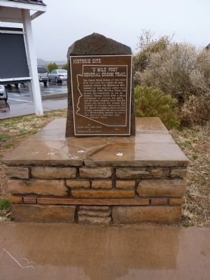
The Crook Road begins at this point
with the first in a series of mile markers
across the Mogollon Rim segment of the
military supply trail connecting Forts
Whipple, Verde and Apache. Reconnoitered
in 1871 by General George Crook with a . . . — — Map (db m28561) HM
It is no coincidence that this diorama made its debut at the same time ladders were removed and access to the cliff dwelling ended.
Before the official end of guided tours of the cliff dwelling on October 1, 1951, park rangers had . . . — — Map (db m251673) HM
The abundant alcoves and rock shelters found in cliffs throughout the Verde Valley served as homes, storage units, and spiritual sites.
Wind and water have sculpted countless alcoves, holes, and crannies in the soft layers of the . . . — — Map (db m251679) HM
Water, shelter, building materials, arable land, and other environmental conditions made the Verde Valley an ideal place to live.
Montezuma Castle is the most obvious structure here, but it was part of a larger community that . . . — — Map (db m251684) HM
The bachelor officers lived a somewhat spartan lifestyle, not altogether unexpected considering the low pay, slow promotion, frequent moves, and the amount of time spent in the field. Although these quarters were designed to have three bedrooms, . . . — — Map (db m250262) HM
The oldest settlement in the Verde Valley. Site of historic Fort Verde. The first settlers came into the valley in February, 1865, followed by the military in August, 1865. Original military and historic buildings still stand. — — Map (db m40814) HM
All of the buildings at Fort Verde were built in the typical architectural style once found at nearly every 1870s military post in the United States. There are probably fewer than a dozen such buildings left west of the Mississippi River.
This . . . — — Map (db m250261) HM
To construct their cliff home, residents made use of a naturally eroded alcove and fit 20 rooms into the shape of its contours.
Why build a home in a cliff face? There are many possibilities: proximity to water and farmland, to stay . . . — — Map (db m251687) HM
Between approximately 1100 and 1400, the Castle neighborhood also included a larger pueblo and numerous small alcove homes in the cliff face along Beaver Creek.
Nestled in a limestone cliff overlooking the creek, Montezuma Castle . . . — — Map (db m251691) HM
Around the year 1400, people began leaving their homes here. Five hundred years later, its walls were still largely intact.
The builders chose their home site wisely, taking advantage of the shelter that a natural alcove provided. . . . — — Map (db m251685) HM
Fort Verde’s flagpole was designed like a ship’s mast, just like many other military fort flagpoles that were built in the 19th century. This design supports an upper and lower timber, which allows for the use of shorter logs. Often a single tree . . . — — Map (db m159103) HM
The Mythology of a Western Fort
Fort Verde is typical of western forts built in the 1870's and 1880's but our vision of forts comes from movies. Log stockades with towers and John Wayne fearlessly firing his rifle at attacking Indians. The . . . — — Map (db m40815) HM
While many details of life in this settlement will never be fully known, it is clear that farming, craft, and trade thrived here.
The space where you have been walking was a small part
of the farmland cultivated by the people of . . . — — Map (db m251677) HM
Memories, stories, and traditions continue to bind people today to this cultural heritage site.
The community surrounding Montezuma Castle was one of related households both familial and social units. The Hopi Parrot, Bear, Water, . . . — — Map (db m251657) HM
The Civil War has ended, the country opens up for expansion in the West, and conflicts of a different nature face the L.L.S. Military. The Indian Wars of the 1870s-1880s brought soldiers to Arizona to protect the settlers and brought challenges to . . . — — Map (db m159088) HM
Around 1400, after centuries of settlement here, families began leaving their Verde Valley homes.
The archeological record suggests that from 1350 to 1400, people began to leave the valley and join larger pueblos to the north and . . . — — Map (db m251675) HM
Pecan Lane Rural Historic Landscape was added to the National Register of Historic Places on May 2, 2000.
Pecan Lane played a significant part in the agricultural history of Camp Verde. During
the late 19th century and early twentieth . . . — — Map (db m27855) HM
This cliff may seem a featureless stone face with a few holes and broken walls, but look closely and the rocks reveal the outline of a once large and vibrant neighbor to Montezuma Castle.
Because Montezuma Castle suffered extensive . . . — — Map (db m251682) HM
One of three made in Ames Iowa in 1920. Powered by a 90 HP 4 cylinder Hercules gas engine, LPX patent. Bucket capacity 1 cubic ft. This link belt excavator power shovel was used in the Camp Verde Salt Mine in 1928. — — Map (db m251643) HM
There were two married officers’ quarters built at Fort Verde in 1871, both designed in the Mansard style. The style “disguises” the second floor by extending the line of the roof down. It was a popular style from the 1850s through the . . . — — Map (db m159091) HM
The foundation before you is from one of two Married Officers Quarters. This two-story building was architecturally identical to the Commanding Officers Quarters, but with a reversed floor plan.
After the U.S. Army abandoned the fort, the . . . — — Map (db m159101) HM
Each permanent military command was required to have a physician. The Post Surgeon was allowed these rather spacious accommodations because patients were treated and surgery was performed here.
The Post Hospital was located at the northeast . . . — — Map (db m159092) HM
The following named individuals were assigned, either permanently or temporarily, to Camp Verde, Arizona Territory. While stationed here their personal action in combat was above and beyond the call of duty, earning them the nation's highest . . . — — Map (db m28593) HM
Montezuma Castle invites us to pause in wonder at the ingenuity of the people who began building it over 700 years ago.
Ancestors of today's Puebloan peoples built and occupied the Castle. We can only speculate why they chose to . . . — — Map (db m251692) HM
In memory of Wales Arnold.
Co. E, 5th Cal. Vol. Inft.: Scout in
Apache Wars: Post trader at Camp
Verde: Pioneer farmer in Verde
Valley: and of his wife, the
beloved ”Aunty Arnold” of
all the Verde. — — Map (db m100022) HM
From a few rooms on the hilltop to a 110-room pueblo, this dwelling transformed over centuries as increasing numbers of people came together to form a community.
The pueblo you see today was not built all at once or with a plan, but . . . — — Map (db m250272) HM
Since excavation exposed them to erosion, floors and wall segments have required ongoing preservation treatments.
A building held together with mud mortar requires regular upkeep. After the original residents moved on, the mortar eroded, . . . — — Map (db m250276) HM
Clarkdale was planned, owned and developed by William A. Clark of Montana, owner of the United Verde Copper Company on Cleopatra Hill in Jerome. In 1911 Clark decided to change from the extraction process of mining to an "open pit" method. Because . . . — — Map (db m33200) HM
We can learn a lot of information about the people who lived in the pueblo from what they left behind.
The hillside below you was a refuse site that yielded clues about the diet and daily life of the people of the village. We know they . . . — — Map (db m250274) HM
Although they shared similar lifestyles and cultures, the people living here held some traditions that differed from their Puebloan neighbors to the north.
In this room, excavators discovered a partial wall underneath the floor - people . . . — — Map (db m250273) HM
An exploration of Tuzigoot pueblo inspires questions, answering some while provoking others. The story along this trail recounts people both ancient and modern.
Along this 1⁄3-mile (0.5 km) loop trail, you will find the remains . . . — — Map (db m250267) HM
After calling Tuzigoot home for centuries, shifting circumstances heralded change for the people of the Verde Valley.
Tuzigoot and other pueblos throughout the Verde Valley were occupied for hundreds of years-longer than the United . . . — — Map (db m250281) HM
People have long been drawn to settle in the Verde Valley for its plentiful food sources, water, and natural shelters.
The earliest people to arrive here left behind fluted spear points that date to 13,000 years ago. About 1,500 years . . . — — Map (db m250270) HM
The mineral deposits hidden in this landscape sustained life in the Verde Valley in the past and today.
Just as minerals in the land sustained this prehistoric hilltop village, the copper beneath the earth provided the basis for founding . . . — — Map (db m250278) HM
At varying times in the past, local economies and people's cultural practices depended on the Verde Valley's mineral resources.
For the people of Tuzigoot, rocks were the source of material for paints, adornments, and stone carvings that . . . — — Map (db m250277) HM
On Thursday June 21st, 1928,
Clarkdale was robbed.
At 11:00 A.M., Willard Forrester and Earl Nelson stopped in front of Clarkdale's
Bank of Arizona.
Forrester stepped into the bank and emerged shortly carrying $50,000 dollars. As . . . — — Map (db m307467) HM
If Tuzigoot's plaza served a role like those of pueblos today, this flat, open area between rooms would have been the hub of social and ceremonial activities.
In modern Hopi society, plazas are central to the pueblo community. The plaza . . . — — Map (db m250280) HM
The U.V.C.C. Clarkdale smelter was built through the vision of William A. Clark, owner of the United Verde Mine in Jerome. The Smelter was constructed between 1912-1915 to replace the outdated Jerome smelter.
On May 26, 1915 the first furnace . . . — — Map (db m33199) HM
In 1932, Charles Bell constructed this trail through the rugged canyon of Wet Beater Creek. It was, and still is, used to move cattle up and down the Mogollon Rim. Bell Trail is six miles to the edge of the Rim and climbs a rocky 1200 feet in the . . . — — Map (db m187583) HM
Lifeline
Beaver Creek has always been a major focus of life in the Verde Valley. Prehistoric Sinagua farmers constructed Montezuma Castle and other structures near the creek. They dug ditches to carry creek water to irrigate the fields of . . . — — Map (db m40868) HM
Could This Stone Be The Opening to a Macaw Pen?
Where Did This Stone Come From?
Who Used It?
Why Is This Stone at Montezuma Castle?
Did the Ancient Sinaguans Possibly
Raise Macaws Here?
In the 15th century, near modern-day Casa . . . — — Map (db m40895) HM
A farming community of perhaps 200 people prospered here for more than three centuries. The Castle was home to 35 or so of these people. Archeologists suggest they may have fled what is today the Flagstaff area due to overpopulation around A.D. . . . — — Map (db m40840) HM
The Neighborhood
You can see Montezuma Castle and Castle A from here. If you look closely at the Cliffside, you might spot other ledges and caves used by the Sinagua.
The Sinagua people who made their homes here may have been a . . . — — Map (db m40869) HM
Here’s another “castle” – this one called “A” by the archeologists who excavated it in the 1930s.
Like neighboring Montezuma Castle, Castle A was occupied by Sinagua farmers between A.D. 1200 and 1450. However, with 45 rooms and an estimated . . . — — Map (db m40863) HM
The Way Up
How in the world do you build a structure large enough to house 35 people high up on a steep canyon wall? Sound impossible? Here’s how Montezuma Castle’s ingenious Sinagua farmers managed it.
Pause a few moments to enjoy this view of Montezuma Castle. Don't you suppose it must have stopped the settlers and soldiers who first saw the cliff-dwelling over a century ago?
The odd name came from a mistaken belief that the cliff-dwelling . . . — — Map (db m40819) HM
The Historic Chaves Trail passed near this location. The Chaves Trail is named for Lt. Col. J. Francisco Chaves, First Cavalry, New Mexico Volunteers who traveled north of here April 16-21, 1864 with two officers, thirty-five enlisted men, and . . . — — Map (db m132627) HM