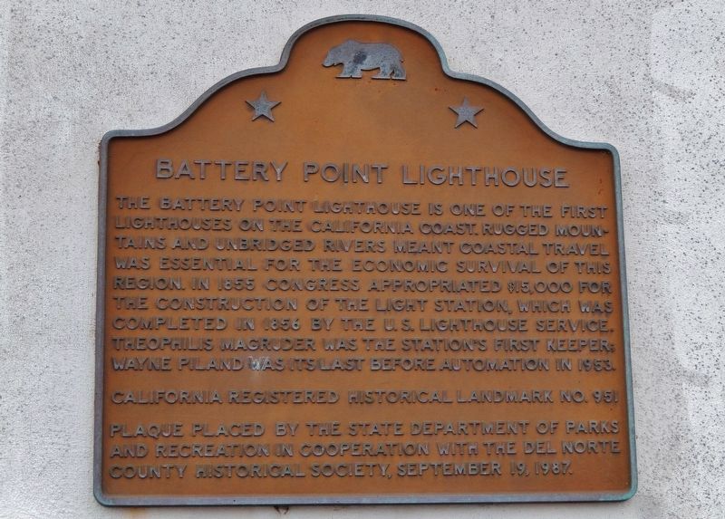
The Battery Point Lighthouse is one of the first lighthouses on the California Coast.
Rugged mountains and unbridged rivers meant coastal travel was essential for the economic survival of this region.
In 1855 Congress appropriated $15,000 for . . . — — Map (db m101692) HM
A United States military post was established here September 12, 1862 by the men of Company G, 2nd Regiment, Infantry, California Volunteers, to keep peace between the Indians and the miners and settlers of northwestern California. It was abandoned . . . — — Map (db m176820) HM
During the evening of March 27, 1964 a massive earthquake shook Alaska’s Kenai Peninsula heavily damaging Anchorage, located more than 60 miles away, and sending a tsunami racing across the Pacific Ocean. About four hours later, on March 28, the . . . — — Map (db m114260) HM
1.76 Acres of this parkland have been donated by the
family of Henry Sause, Jr. Who, with his brothers,
Curt and Paul, pioneered the transportation of forest
products by tug and barge. From 1949 to 1962, Sause
Bros. Ocean Towing Company moved in . . . — — Map (db m92063) HM
This Unit of 500 Acres in the
National Tribute Grove
is preserved through the
National Society
Daughters of the American Revolution
to honor those who served in the armed forces
of the United States in World War II
and to . . . — — Map (db m241927) WM
Constructed in 1858, this was the route of the Crescent City Turnpike. Following the present Elk Valley Road to Old Camp Lincoln, it then crossed the ridge, forded Smith River to low divide, and continued to Jacksonville, Oregon, by way of various . . . — — Map (db m176819) HM
Through the collective recognition of the Community of Nations
expressed within the Principles of the
Convention concerning Protection of the World
Cultural and Natural Heritage, Redwood National Park
has been designated a
World Heritage . . . — — Map (db m182011) HM
The monument you are looking at is dedicated to Billy Boone. But who was Billy Boone? Former newspaper publisher Wally Griffin, remembers him as a "promoter" of Del Norte County, but most people who remember him recall that he was instrumental in . . . — — Map (db m92062) HM
Nearby are portions of the hull of the General Petroleum Corporation tanker S.S. Emidio, which on December 20, 1941 became the first casualty of the Imperial Japanese Navy's submarine force action on California's Pacific Coast. The ship was attacked . . . — — Map (db m143397) HM WM
Discovery the unique features of an old-growth redwood forest. Welcome to the Simpson-Reed Discovery Trail!
You are in the midst of an ancient redwood forest. Here, you will see trees of many ages that create a multi-layered forest ceiling or . . . — — Map (db m87814)
Simpson-Reed Grove for the perpetual enjoyment of all--This grove was presented to the State of California by the Simpson Timber Company in memory of Mark E. Reed, its president from 1914 to 1955. — — Map (db m87815) HM
These giant jacks are used to protect harbors from damaging current. As waves hit the tetrapods, the force of the water is dissipated by the curve of the legs. There are 1630 tetrapods on the ocean side of the Crescent City breakwater. There are . . . — — Map (db m181238) HM
This grove is given to the State of California for the preservation of these ancient trees by Mr. and Mrs. Jesse H. Metcalf of Rhode Island. — — Map (db m1510) HM
At the time of white contact the principal villages of the native Tolowa Indians of northern Del Norte County were located at Battery Point in Crescent City (Ta'atun), Pebble Beach (Meslteltun), south of Point St. George (Tatintun), and north of . . . — — Map (db m164583) HM
The townspeople of Crescent City slumbered peacefully in the late-night hours
of March 28, 1964 - tragically unaware of a catastrophe at their doorstep.
Earlier whipped into fury by a devastating Alaskan earthquake, seismic waves
raced . . . — — Map (db m183645) HM
Thirty-seven tsunamis have been observed or recorded on the North Coast since
the first tide gauge was installed in Crescent City in 1933. All but five were tele-tsunamis (the source was far away). Crescent City, known as "Tsunami Central,” has . . . — — Map (db m183655) HM
This memorial is dedicated to those who lost their lives in the wreck of the Pacific Mail Steamer, Brother Jonathan, at point St. George's Reef, July 30, 1865. — — Map (db m76459) HM
The heroic voyage of this crossbreed steer; floating downriver from Klamath Glen and up the coast into Crescent City Harbor, was an inspiration to the flood victims of Klamath. He embodied their courage, stamina, and indomitable spirit. A living . . . — — Map (db m91941) HM
Disguised to Protect
After the bombing of Pearl Harbor during World War II, the possibility of enemy attack on the U.S. mainland became very real. At one point, Japanese submarines operated in offshore waters and
actually shelled some . . . — — Map (db m285203) HM
Site of Fort Terwer, United States military
post established October 12, 1857, by First
Lieutenant George Crook and men of
Company D to keep peace between the Indians
and whites. The fort was destroyed by a flood.
in December, 1861, and . . . — — Map (db m240409) HM
During Christmas week in 1964, this area) was hit with the heaviest rain ever recorded in the region, Torrential storms dumped as much as 21 inches of warm rain over the mountains, melting the snow pack. Swollen creeks and rivers raged through . . . — — Map (db m285204) HM
James Earle Fraser and his End of the Trail
What you see here is a copy of the famous "End of the Trail" statue. You have probably seen this image in many forms from small statues to bookends to belt buckles all across the United . . . — — Map (db m183669) HM
In Memory of
Co. E & I 2nd. California Volunteer Infantry 1862 - 1863
Co. B 1st. Battalion Mountaineers California Volunteers 1863 - 1864
Co. A. 1st Battalion Native California Volunteer Calvary 1864
and
Marie Brizard Todd, . . . — — Map (db m32567) HM
On this site
the Rev. Asa White
formed the first Methodist Society
on Humboldt Bay, July 4, 1850
Arcata United Methodist Church
June 24, 2000 — — Map (db m98180) HM
The basement and first story of the building,
at 8th and H streets (opposite), was constructed
in 1857 for Augustus Jacoby. For many years
it was a principal supply point for the Klamath
Trinity mining camp trade. From 1858 through
1864 it . . . — — Map (db m143579) HM
In 1857, pioneer merchant Augustus Jacoby built
his two-story "Fireproof Storehouse" here of stone.
Partial walls of that original structure still support this building
in the N.W. corner of the 1st and 2nd floors and are . . . — — Map (db m182937) HM
Originally built in 1857 by Augustus Jacoby, this building was constructed of locally quarried stone and brick. This was the first fire proof building in Humboldt County. Jacoby left Arcata in 1862 and mercantile firms continued to occupy the . . . — — Map (db m94513) HM
The nation's oldest theatre built for feature films was opened on December 3, 1914, by Isaac Minor with a silent film based on Charles Dickens' "The Chimes" directed by Herbert Blaché starring Tom Terriss.
Arcata Historic Landmark #28
This . . . — — Map (db m60930) HM
This site, 645 10th Street, has long been a travel
hub beginning with a Stage Depot that served those
traveling by horse and buggy through the
introduction of the automobile. The Arcata Bus
Depot building replaced the Stage Depot and . . . — — Map (db m208622) HM
Dedicated to the
Gregg-Wood Party
and
Members of the Union Company
Founders of the
Town of Union
Now known as the City of Arcata
April 30, 1850
Members of the Gregg-Wood Party
Dr Josiah Gregg · Thomas Sebring ·
David A. . . . — — Map (db m143253) HM
Be it known that at this site in Dec. 1854 work began on the Union Plank Walk Railtrack and Wharf Co. The railroad, in use by Jan. 1855, was the earliest operating state authorized railroad in California. The wharf, completed in May 1855, was 1.5 . . . — — Map (db m248874) HM
Incorporated December 15, 1854, as the Union Plank Walk, Rail Track, and Wharf Company, the Arcata and Mad River Rail Road is the oldest line on the north coast. Originally using a horse-drawn car, the railroad served as a link between Humboldt Bay . . . — — Map (db m113364) HM
Recognized by the American Forestry Association as the National Champion Coast Redwood, Sequoia sempervirens, November 1991. Height • 363 feet Circumference • 53.2 feet Average crown spread • 62 feet — — Map (db m165464) HM
Striking sawmill workers gather in a mass picket at a redwood mill due west of Fort Humboldt on June 21,1935, trying to convince local redwood mill owners to bargain with their union.
Police ordered the strikers to disperse. As they were . . . — — Map (db m190781) HM
Richard Sweasey originally financed the construction of this theater which displays his name. Mr. Sweasey was a businessman in the early days of Eureka. Sweasey served as a member of the California State Legislature and several terms as a Humboldt . . . — — Map (db m71971) HM
Single-story, wood commercial building, designed and built by E.C. Mowry. Original superb ornamental cornice. The three shopfronts had been altered, but were restored by Bob Imperiale in 1980s. — — Map (db m233387) HM
Built for Captain H.H. Buhne; Humboldt County Bank, other businesses, residences, public hall, rooftop signal service station.
This program made possible through a partnership with property owners Kelly and Kala Martin, Eureka Main Street, and . . . — — Map (db m61275) HM
—c 1858—
Buhne General Store
Greek Revival Architecture
Eureka’s Oldest Commercial Building
Captain H.H. Buhne, Proprietor
Eureka Historical Landmark
This program possible through a partnership with property owners Globe . . . — — Map (db m60214) HM
Richardsonian Romanesque architecture
Samuel Newsom, Oakland architect; Built for
William Carson; Randall Banking; A. Crocker
Brothers Department Store; First Professional
Offices; Ingomar Theatre and Opera House.
Eureka Historic . . . — — Map (db m176802) HM
Dedicated to the memory of my parents
Joseph H. & Annie F. Clarke
and other pioneers of Northwestern California
by Cecile Clarke
Dedicated August 21, 1960 by the Native Sons of the Golden West — — Map (db m1505) HM
Built for Annie M. Wallace; first concrete commercial building in Eureka; contractor materials sold until 1960.
This program possible through a partnership with property owner Dolores Vellutini, Eureka Main Street, and the Eureka Heritage . . . — — Map (db m61221) HM
Janssen's General Merchandise, first elevator and first fireproof building in Eureka
This program made possible through a partnership with property owner Dolores Vellutini, Eureka Main Street, and the Eureka Heritage Society — — Map (db m60513) HM
Served passengers traveling by steamers docking at nearby wharves.
This program possible through a partnership with property owners Lee & Kwang Cho, Eureka Main Street and the Eureka Heritage Society. — — Map (db m61129) HM
Eureka was founded as a town in 1850 and incorporated as a city in 1874. Located on the remote northwestern coast of California, Eureka was the region's major port of entry by water in the 19th century before the construction of good access by land, . . . — — Map (db m113509) HM
Built for Josiah Bell; college upstairs; steamship ticket agency, bicycle shop, and grocery store downstairs; stable; 1893, second building attached.
This program possible through a partnership with the estate of Robert Imperiale, Eureka Main . . . — — Map (db m61170) HM
Architect J.W. Rowell designed the masonry building which featured a classical entry portico, an elegant cupola with skylights, and street facades of granite blocks, buff-colored bricks, and sandstone detailing.
Built by the Lyon-Wilson . . . — — Map (db m60275) HM
This property
The Eureka Inn
has been placed on the
National Register of Historic Places
by the United States Department of the Interior — — Map (db m71977) HM
Streamline Moderne Architecture
Built for George Mann; William B. David,
architect; striking neon blade sign,
curved-edge canopy, and Moderne interior
Eureka Historic Landmark — — Map (db m176787) HM
Here, on the block of land bounded by E, F, 4th, and 5th streets, over 300 Chinese people once lived in a bustling Chinatown. But high unemployment, economic uncertainty, and a perceived competition for jobs served as excuses for anti-Chinese hate. . . . — — Map (db m233370) HM
This former sausage factory was purchased in 1919 by Angelo Fanucchi and his wife, Teresa Ceccorelli, immigrants from Tassignano, Italy. They opened a cigar shop with a hidden speakeasy. In 1924 the building also became the home of the Fanucchis and . . . — — Map (db m233389) HM
By the early 1850's, newly arrived white settlers had moved into the Humboldt Bay area, causing conflict with the native inhabitants. To protect both Indians and settlers, Fort Humboldt was established in 1853 and operated until 1866. It became a . . . — — Map (db m19936) HM
Hal, a native of San Diego, was graduated from San Diego State College with a degree in Civil Engineering, and subsequently started work with the California Division of Highways in that area.
As a person dedicated to serving the needs of . . . — — Map (db m1556) HM
Built by Knowles Evans for John and Peter Healy for their tinware and harness business. Tenants have included hardware store, Dreamland Dance Hall, a roller rink and the Old Town Bar and Grill. Damaged by multiple earthquakes it was red tagged in . . . — — Map (db m233360) HM
Built in 1884, this building became home of “Columbia Hose Company Number 4”, chartered April 2, 1894. It is the oldest surviving structure of the 7 volunteer companies organized in Eureka between 1873 and 1908. Original building had 2 . . . — — Map (db m91922) HM
Captain Jonathan Winship made the first recorded entry into Humboldt Bay by sea in June 1806. Encountered in 1849 by Josiah Gregg’s party. New word of its existence reached San Francisco. By 1850 the Laura Virginia Association had founded Humboldt . . . — — Map (db m1555) HM
National Historic Landmark
This site possesses national significance in commerating the history of the United States of America.
1964
National Park Service
United States Department of the Interior — — Map (db m32570) HM
Built for J. McLauchlan, restaurant, saloons downstairs; alpine rooms upstairs; one of the longest operating bordellos
Eureka Historic Landmark
This program possible through a partnership with property owner Dr. Marybeth Wolford, Eureka . . . — — Map (db m1507) HM
Iron front cast by Eureka Foundry; men's clothier and furnishings, Louvre Cafe, saloons
Eureka Historic Landmark
This program possible through a partnership with property owner Wes & Nedra Kausen, Eureka Main Street, and the Eureka . . . — — Map (db m1508) HM
This property
is listed in the
National Register
of Historic Places
by the United States
Department of the Interior
John A. Cottrell House
c. 1902 — — Map (db m176767) HM
Queen Anne Architecture
Built for Zipporah Russ & Sons Co.
Redwood Land & Investment Co.
Belcher & Crane Abstract Co.
Humboldt Club — Gentleman's Social Club
Eureka Historic Landmark — — Map (db m176808) HM
Built for Bessie P. Lindsay; Connick & Cousins/G.M. Connick & Co. Grocery Store Downstairs, Offices Upstairs; Later State Department of Employment Downstairs — — Map (db m233400) HM
Fishermen’s Terminal
Before the railroads reached Eureka in 1914, the ocean was the highway. The large green-roofed building to your right is the Fishermen’s Terminal built in the early 2000s. It sits upon the site of the Nelson Steamship Co. . . . — — Map (db m233409) HM
F.T. Georgeson, Architect; Meeting Site for Humbolt Lodge No. 79 and other lodges upstairs, department and furniture stores downstairs — — Map (db m233367) HM
Built for A.R. Abrahamson; furnished rooms upstairs; businesses and Abe's Chop House downstairs.
This program possible through a partnership with property owners Evo & Catherine Fannucchi, Eureka Main Street, and the Eureka Heritage Society. — — Map (db m61533) HM
This historic building was erected in 1887 by L.T. Kinsey and sold to the Society of Humboldt County Pioneers in 1890. On June 15, 1897 it was purchased by Humboldt Parlor No. 14 N.S.G.W. — — Map (db m71970) HM
Needs Lodging; meeting hall; jewelers, tailors, other retail; offices; L.H. Hess businesses; Monterey Hotel.
This program made possible through a partnership with property owner Williams Family, Eureka Main Street, and the Eureka Heritage . . . — — Map (db m61383) HM
Dry goods, saloons, Cafes Royal and Oberon (Site 1910 Jack London fight), used furnishings
This program possible through a partnership with property owners Roy and Susan Kohl, Eureka Main Street, and the Eureka Heritage Society — — Map (db m60277) HM
Built by B.C Mowry and Knights of Pythians
Members for Lodge # 34
Alterations by Barbara Groom,
Owner: Lost Coast Brewery, Apartment, and Theatre
Eureka Historic Landmark
This program possible through a partnership with
property owner . . . — — Map (db m142819) HM
Single Story Masonry With Cast-Iron Storefronts. Built For C.S. Ricks by Clark (Brickwork) and Dauphiny (Carpentry) following fire of a Wooden Structure. “Modernized” 1916; Stuccoed 1927; Restored 1977 by Mark Carter. — — Map (db m233402) HM
The Ritz and Star Cigar Store, Proprietors A. J. Batini and Dolindo Massei; The Ritz Club, restoration by Daniel and Jayne Ollivier, 1978; The Ritz Apartments
This program possible through a partnership with property owners Daniel & Jayne . . . — — Map (db m60897) HM
-John Innocent Veniaminov (1797-1879)
- First Pastor of Alaska and the Northwest (1824)
- Sails outside Humboldt to Fort Ross (1836)
- First bishop of the Church (1840)
- Defender of the Native peoples and cultures — — Map (db m142808) HM
EFD Chief: Oscar Paul
Sequoia Company No. 6 Foreman Walter S. Selvage
Mustered into service by Ordinance #357 on July 12, 1904
On July 3, 1904 the property at 1766 J Street was purchased from C. G. Taylor for $550. Construction began on the . . . — — Map (db m159665) HM
Sequoia Park Zoo has been an integral part of Eureka's community since 1907. Founded on land acquired from the Glatt family to be used as a city park, the zoo has provided a home for many cherished animals and fond family memories. For more than a . . . — — Map (db m219657) HM
904 G Street, Eureka
has been placed on the
National Register
of Historic Places
by the United States
Department of the Interior
1892 — — Map (db m176777) HM
Was consecrated by Bishop Manogue on June 6, 1886 - built by local architect James Simpson under the direction of the pastor, Father John S. Sheridan. It is the second church constructed at this location.
Dedicated by the Grand Parlor . . . — — Map (db m108024) HM
This home, also known as the “Pink Lady,” is a classic Queen Anne/Eastlake Victorian residence designed by the prestigious architectural firm of Newsom Brothers of San Francisco. It was completed in 1889 for William Carson, a pioneer lumber baron . . . — — Map (db m1498) HM
built in 1888 by
William S. Clark
has been placed on the
National Register
of Historic Places
by the Unites States
Department of the Interior — — Map (db m176735) HM
In 1895 3 buildings existed:
412 - Long's Saloon;
414 - W.S. Clifton, optician;
418 - C.W. Richardson, barber.
This program made possible through a partnership with property owners Nedra & Wes Kausen, Eureka Main Street, and the Eureka . . . — — Map (db m61187) HM
Saloons, Kitty Farris' Joy Emporium, and Fairwind and New Fairwind Cafe.
This program possible through a partnership with owners Ferguson-Winsted, Eureka Main Street, and the Eureka Heritage Society. — — Map (db m61155) HM
After finding Humboldt Bay from the sand dunes near Fairhaven on December 20, 1849, the Dr. Josiah Gregg exploring party reached the present site of Eureka. December 26, passing an open area near this point, to camp by an Indian village close to . . . — — Map (db m91923) HM
On Nov. 10, 1908, a deed from George and Edith Connick to Sunset Telephone and Telegraph Company, Block 56, Parcel 5, corner of 6th and “F” Streets was recorded. When Pacific Telephone and Telegraph took over the Sunset Telephone and Telegraph . . . — — Map (db m233368) HM
The six Victorian era houses “905-935” Third Steet were developed by Samuel McFarland from 1884 to 1904. Mr. McFarland came to Humboldt County from New Brunswick, Canada in 1866 at the invitation of his brother-in-law, William Carson
Mr. . . . — — Map (db m71972) HM
The Hotel Vance was built in 1872 by Eureka pioneer & lumberman,
John Vance. It was the area's grandest hotel & the first building in
Eureka with electricity. It was originally designed & built in the
"Modern Italianate style”, which included a . . . — — Map (db m135459) HM
Romano Gabriel spent nearly three decades making the hundreds of brilliant objects filling the front yard of his Eureka home. Gabriel fashioned his brightly painted trees and flowers out of vegetable crates, adding droll faces and figures. Some of . . . — — Map (db m176791) HM
This was the first building expressly constructed for the Eureka Post
Office Postmaster Frederick Aze, (served as Eureka postmaster for 17
years.) motivated by cramped and ill suited facilities at 612
Second St. had this building constructed at . . . — — Map (db m135482) HM
-1874/1902-
Vance Hotel
Second Empire/Italianate Architecture
Built for lumber pioneer John Vance; A first
class hotel to 1950's; First commercial building
with electric lights
Eureka Historic Landmark
This program possible . . . — — Map (db m233429) HM
663 entries matched your criteria. The first 100 are listed above. Next 100 ⊳